- Föhr
Infobox Islands
name = Föhr
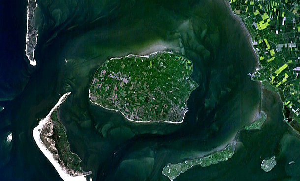
image caption = Satellite map
image size =
locator
map_custom = no
native name = Feer, Før
native name link =
nickname =
location =Wadden Sea
coordinates = coord|54|43|N|8|30|E|region:DE_type:isle
archipelago =North Frisian Islands
total islands =
major islands =Sylt ,Föhr ,Amrum
area = 82.82 km²
length = 12 km
width = 6.8 km
coastline =
highest mount =
elevation = 13 m
country = Germany
country admin divisions title = State
country admin divisions = flag|Schleswig-Holstein
country admin divisions title 1 = District
country admin divisions 1 =Nordfriesland
country admin divisions title 2 =
country admin divisions 2 =
country capital =
country largest city =
country largest city population =
country leader title =
country leader name =
country 1 =
country 1 admin divisions title =
country 1 admin divisions =
country 1 capital city =
country 1 largest city =
country 1 largest city population =
country 1 leader title =
country 1 leader name =
country 2 =
country 2 admin divisions title =
country 2 admin divisions =
country 2 capital city =
country 2 largest city =
country 2 largest city population =
country 2 leader title =
country 2 leader name =
population = 8,593
population as of = 17 Jul 2008
density = 104
ethnic groups =Germans, Frisians, Danes
additional info =
website = [http://www.foehr.de www.foehr.de]Föhr ("Fering" North Frisian: "Feer"; _da. Før) is one of the
North Frisian Islands on the German coast of theNorth Sea . It is part of theNordfriesland district in the federal state ofSchleswig-Holstein . Föhr is the second-largest North Sea island of Germany.Geography
Föhr is situated southeast of
Sylt , it is the second-largest German North Sea island. Among those German island which are only accessible by ship or airplane Föhr is the most populous one and has the largest surface.Föhr is called "The Green Island" due to being sheltered from the storms of the North Sea by its neighbouring islands Sylt and
Amrum , so that Föhr's vegetation is thriving compared to other islands. It is 6.8 kilometres wide and 12 km long, the surface measures 82.82 km². While the northern parts aremarshland , the south consists of highergeestland . The highest elevation measures 13 m above mean sea level and is located on the geestland ridge between the villages ofNieblum andMidlum . The geest makes up about two fifth of Föhr's total area and most villages are located there. In the marshlands, a number of solitary farmsteads can be found, which were moved out of the villages during the 1960s.Until the "
Grote Mandrenke " flooding, Föhr had not been an island but was part of the mainland, being connected to the sea by deep tidal creeks.Föhr, like its neighbour islands, is a popular tourist resort. From the ferry terminal a sandy beach of about 15 km length extends all along Föhr's southern shore and halfways up the western coast. North and northwest of Föhr the Reserved Area I of the Schleswig-Holstein Wadden Sea National Park is located.
Föhr's population counts 8593 (as of 17 July 2008). [cite web|url=http://www.amt-foehr-amrum.de/f_portr.htm|title=Zahlen, Daten, Fakten|publisher=Amt Föhr-Amrum|language=German|date=2008-07-17] The only town on the island is Wyk on its south eastern coast which is a popular seaside resort. In addition there are sixteen tiny hamlets on Föhr which are distributed among eleven municipalities. They adhere to the "Amt"
Föhr-Amrum :*
Alkersum (Fering: "Aalkersem")
*Borgsum ("Borigsem")
*Dunsum ("Dunsem"), comprised of Lesser and Greater Dunsum
*Midlum ("Madlem")
* "Nordseebad"Nieblum ("Njiblem") with its neighbourhood Goting ("Guating")
*Oevenum ("Ööwnem")
*Oldsum ("Olersem") the districts of Toftum ("Taftem") and Klintum ("Klantem")
*Süderende ("Söleraanj")
*"Nordseebad"Utersum ("Ödersem") with the neighbourhood of Hedehusum ("Hedehüsem")
*Witsum ("Wiisem")
*Wrixum ("Wraksem")A local peculiarity is that almost all place names end with the suffix -um, which means "settlement".
History
The higher geestland cores of the North Frisian islands, scattered between ample marshlands, attracted settlers when the sea level rose at the end of the
Neolithicum . Gravesites and several minor artifacts found on Föhr bear witness to this.When the
Frisians colonised the area of modern Nordfriesland during the 7th century, their first settlements were erected on Föhr, according to archaeological findings. The formerly sparsely inhabited island witnessed a steep rise of population. A rather large amount of jewellery originating fromScandinavia that was found in graves of the time points out a vivid connection to northern Europe. [cite book|last=Bantelmann|first=Albert|title=Landschaft und Besiedlung Nordfrieslands in vorgeschichtlicher Zeit (Landscape and Colonisation of Nordfriesland in prehistorical Times)|language=German|series="Geschichte Nordfrieslands" (History of North Frisia)|isbn=3-8042-0759-6|pages=15-56, 46] From the age of theVikings several ring walls, the "Lembecksburg" among them, are preserved. [ [http://www.jswis.de/Foehr/Lembecksburg.htm Lembecksburg] (in German).]The "Earth Book" of King
Valdemar II of Denmark tells of two "Harden" on Föhr, territorial subdivisions of the time. The Westerharde Föhr was at times the refuge of apirate serving the Danish. [cite book|last=Panten|first= Albert|title=Die Nordfriesen im Mittelalter (The North Frisians in the Middle Ages)|series="Geschichte Nordfrieslands|isbn=3-8042-0759-6|pages=57-102, 71] In 1368 the Westerharde, which also included Amrum, was transferred to the Counts ofHolstein by supervision of knight Klaus Lembeck,bailiff ofRibe . In 1400 the Harde surrendered to QueenMargaret I of Denmark and remained within Ribe County. Until 1864 the western part of Föhr, together with Amrum, belonged to the Danish Enclaves in North Frisia while Osterland and Wyk belonged to the Duchy ofSchleswig since it had seceded from the Danish Kingdom in the 1420s. Together with theWiedingharde , theBökingharde , the isle of Strand and Sylt, Osterland in 1426 signed the "Compact of the Seven Hundreds" (German: "Siebenhardenbeliebung") with Duke Henry IV of Schleswig, which stated that the Hundreds intended to keep their judicial autonomy.In 1523 the northern marshlands of Föhr were shut off against the sea by dikes and 22
hectacre s of new farming land were won. [cite book|last=Kunz|first=Harry|coauthors=Albert Panten|title=Die Köge Nordfrieslands (The North FrisianPolder s)|isbn=3-88007-251-5]Beginning in 1526, the
Protestant Reformation began to introduce theLutheran confession on Föhr which was completed in 1530.Whaling brought about a Golden Age for Föhr. During the 17th and 18th century most Dutch and English whaling ships would have a crew of Frisians from the islands. In the late 18th century a thousand sailors, 150 Commanders among them, were living on Föhr. Still today the preciously decorated houses of the Commanders can be seen in Nieblum and Süderende. The so-called "talking tombstones" in the cemeteries of the three churches on Föhr account for their vitae. Yet with the decline of the whale populations ever less men would go sailing and the people of Föhr focused on agriculture again.
After 1842, when King
Christian VIII of Denmark chose Föhr as his summer residence, the island became popular as a tourist resort.The three hamlets of Utersum, Witsum and Hedehusum were the only ones to vote for Denmark in Zone II of the
Schleswig Plebiscites in 1920; yet as they were not located directly at the border they remained with Germany.Language
A major part of the population in the west of the island speaks, besides German, a local idiom of the
North Frisian language known as "Fering " or "Föhring". Fering is again divided into the two dialects of Westerland Föhr and Osterland Föhr, being the western and eastern halves of the island respectively. In OsterlandLow German is more popular than Fering and especially in Wyk the traditional language isStandard German .The name Föhr is in parts a derivation from the term "feer" which means "Frisian" as well as "green". Today it is thought that the name derives from German "fahren", to travel, to navigate.
Traffic
The island is accessible by a car ferry connecting the mainland port of
Dagebüll and the town of Wyk (approximately 10-12 sailings a day, crossing time approx. 45 minutes). The ferry port in Dagebüll is connected to the German road and railway networks. There are also frequent car ferry services from Föhr to the neighbouring island ofAmrum (approx. 1 hour crossing time) as well as seasonal pedestrian ferries toSylt and theHalligen .A bus service connects Wyk to all of the island's villages. Föhr can also be reached by small airplanes via an
airstrip .Attractions
Wyk
Sights include a
bell tower (raised in 1886) as well as the "Sandwall"esplanade .Frisian customs and the history of Föhr are displayed at the Dr. Carl Haeberlin Frisian Museum, whose entrance is made up of two whale jaw bones.
Church buildings
The island features three medieval churches from the 12th and 13th century. These are St. Nicolas' church in Wyk-Boldixum, St. John's in Nieblum and St. Lawrence's church in Süderende. The adjacent graveyards contain unusual tombstones which display entire vitae and may show pictures.
Windmills
On Föhr five
windmill s can be found, two of them in Wyk (a Dutch mill called "Venti Amica" from 1879 in the old town and a buck mill from HalligLangeneß at the museum), as well as one in Wrixum (an octogonal Dutch mill), one in Borgsum (Octogonal Dutch mill, rebuilt in 1992 after the previous building was ruined by fire) and one in Oldsum (octogonal Dutch mill from 1901). Save for the buck mill and the mill at Wrixum all those are privately owned.Archaelogy
Several
dolmen s account for a colonisation of the island during theBronze Age . Today 17 of them can be visited, most of which are located in the southwest of Föhr.Near Borgsum the "Lembecksburg" can be seen, a ring wall from the Viking Age with a diameter of more than 100 metres and eight metres of height. A tale goes that Klaus Lembeck resided here as Steward of the Danish King in the Middle Ages.
Decoy ponds
In the marshlands six
decoy ponds can be visited.Wadden Sea
The entire sea surrounding Föhr may also be designated an attraction. Mainly the foreland north of the sea dike, but also the
mud flat s provide ample space for all kinds ofseabird s. Oystercatchers,common eider s,shelduck s, snipes andpeewit s are only a few of them. Moreover, during the season vast swarms ofmigratory bird s will rest at Föhr and the neighbouring islands. Occasionally, especially after severe winter storms,harbour seal s may be encountered on the beaches.The beach along the southern shore is popular for swimming. Also, during low tide it is possible to hike from Amrum to Föhr.
ee also
*
Leew Eilun Feer , insular anthem.
*Schleswig-Holstein
*Islands of Germany
*North Frisian Islands
*North Frisian language
*Mudflat hiking References
*reflist
External links
* [http://www.foehr.de/ Föhr, die grüne Insel] - Information on Föhr
* [http://www.foehr-archidee.de/img/logo/foehr_luft2.jpgAerial photo]
Wikimedia Foundation. 2010.