- Rodriguez, Rizal
-
Rodriguez
Bayan ng Rodriguez— Municipality — 
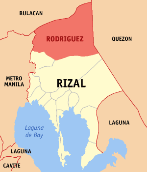
SealNickname(s): Montalban Map of Rizal showing the location of Rodriguez Location in the Philippines
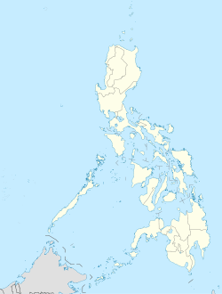
 Rodriguez
Coordinates: 14°43′N 121°7′E / 14.717°N 121.117°ECoordinates: 14°43′N 121°7′E / 14.717°N 121.117°E Country Philippines Region CALABARZON (Region IV-A) Province Rizal District 2nd District of Rizal Founded 1909 Barangays 11 Government - Mayor Cecilio C. Hernandez Area - Municipality 312.70 km2 (120.7 sq mi) Population (2007) - Municipality 223,594 - Density 715/km2 (1,852/sq mi) - Metro Manila Time zone PST (UTC+8) ZIP code 1860 Income class 1st Website montalban.rj25.com/about.htm Population Census of Rodriguez Census Pop. Rate 1995 79,668 — 2000 115,167 8.23% 2007 223,594 9.58% Rodriguez, Rizal is a first-class, urban municipality in the province of Rizal, Philippines. It is the northernmost town in the province and comes after San Mateo, Rizal, and Quezon City coming from Metro Manila. The town is located on the slopes of the Sierra Madre mountain range and features many resorts; it is also the largest town in Rizal province with 312.70 km².
The town's old name, Montalban, refers to its mountainous topography. It was also the town's official name from 1909, until Batas Pambansa Blg. 275 was passed in September 1982, which officially renamed the town. The town's official name is taken from the family name of Eulogio Rodriguez, Sr., one of the most prominent Montalbeños.
According to the latest census, it has a population of 223,594 inhabitants in 24,524 households.
With its fast urbanization and economic growth, the municipality currently ranks as the eighth-richest municipality in the Philippines, with an annual income of Php 310 million (2007).
The legend of Bernardo Carpio is said to have happened in the mountains of the town.
Contents
Built-up Area
With the continuous expansion of Metro Manila, the municipality is now included in Manila built up area which reaches Cardona in its Westernmost part.
Geography
Rodriguez is a town of mountains. From its north to south, a series of sloping ridges, hills and mountains ranges adorn the town. In fact, around 27% or the town is occupied by mountains and slopes. The town's highest peak is Mt. Irid, towering 1,469 meters above mean and sea level.
The province of Rizal spans for 130,383 hectares. Rodriguez makes up 26.8% on the entire province of Rizal, housing 11 barangays. The land mass of Rodriguez is big enough to be an ideal place for many purposes, such as agriculture, commerce such as the Avilon Zoo, and hiking and climbing spots of Wawa Gorge, relocation of communities (having a strategic position east of Rizal, and a lot of areas where lowcost housing projects can be put up), subdivision areas for either low-,mid-,high-cost housing, and also for special uses (such as the landfill).
Elevation and Slope
The Municipality of Rodriguez is generally very rough in topography, with eighty three percent (83%) of its total land area composed of upland areas, hills and mountain ranges. The remaining twenty seven percent (27%) lowlying terrain and rolling lands are found at the southwestern portion of the municipality, along with the northern portions of the Municipality of San Mateo.
This gently rolling to rolling slopes comprises the Marikina River Valley, where water from higher elevations drain towards the Marikina River and its tributaries at the southwestern portion of the municipality. Elevations at these western lowlands range from 10 to 30 meter above sea level. The western portion of the flatlands gently rises towards the west, which is part of Quezon City.
The mountainous regions of the Municipality of Rodriguez are found at the central and eastern areas, with sleepy sloping ridges and mountain ranges, traversing north to south. The terrain in these mountain ranges has slopes ranging from 30-50 percent. Very steep hills and mountains have slopes greater than 50%. Rolling to hilly areas 18-30 percent in slope can also be found. These high elevations are drained by several major rivers, namely the Tanay, Puray, and Rodriguez Rivers.
Transportation
The main transportation used in the municipality were jeepneys, tricycles, SUVs, and buses. There are jeepneys that ply through the towns of San Mateo and Marikina (via Marcos Highway) to Cubao in Quezon City, some ply the route that leads to Philcoa in Quezon City via Batasan Road in San Mateo, others connect Rodriguez to Litex Road in Quezon City. Buses regularly travel to farther places like Makati and Manila. SUVs ply the routes to Cubao in Quezon City and Sta. Lucia Grand Mall in Cainta.
Municipal mayors
- 1909–1916 Municipal President Eulogio Rodriguez
- 1916–1919 Municipal President Eusebio Manuel
- 1919–1928 Municipal President Gregorio Bautista
- 1928–1932 Municipal President Jose Rodriguez
- 1932–1936 Municipal President Roman Reyes
- 1936–1940 Municipal Mayor Jacinto Bautista
- 1941–1943 Municipal Mayor Francisco Rodriguez
- 1943–1944 Municipal Mayor Federico San Juan
- 1945 Municipal Mayor Gavino Cruz
- 1946–1947 Municipal Mayor Catalino Bautista
- 1947 Municipal Mayor Macario Bautista
- 1948–1959 Municipal Mayor Benigno Liamzon
- 1950 Municipal Mayor Guillermo Cruz Sr.
- 1960–1984 Municipal Mayor Teodoro Rodriguez
- 1984–1987 Municipal Mayor Pablo Adriano
- 1988–1993 Municipal Mayor Angelito Manuel
- 1993–1995 Municipal Mayor Ernesto Villanueva
- 1995–1998 Municipal Mayor Pedro Cuerpo
- 1998–2001 Municipal Mayor Rafaelito San Diego
- 2001–2010 Municipal Mayor Pedro Cuerpo
- 2010–present Municipal Mayor Cecilio Hernandez
The town
Rodriguez is politically subdivided into 11 barangays (7 urban, 4 rural):
- San José
- Burgos
- Geronimo
- Macabud
- Mascap
- San Isidro
- San Rafael
- Balite
- Manggahan
- Rosario
- Puray
Tourist attractions
- Avilon Zoo (Montalban Zoological Park)
- Wawa Dam
- Pamitinan Cave
- Puray Falls
- Noah's Park
Malls & Department Stores
- Montalban Town Center Mall
- Puregold Montalban
- Metro Star Department Store
- Robinsons Montalban
- Uno Department Store
- National Book Store
Hospitals
- HVill Hospital
- St. Mark Hospital
- San Jose Maternity and Lying-in Hospital
- Montalban Infirmary
Educational Institutions
There are numerous colleges and universities in the town that offers graduate and undergraduate programs.
Tertiary
- University of Rizal System (URS)
- University of Montalban (Pamantasan ng Montalban)
- Roosevelt College Rodriguez
- St. Joseph's College of Quezon City (Montalban Campus)
- Asian Institute of Computer Studies (AICS)
- Froebellian College of Science and Techonology
Secondary
- Burgos National High School
- Divine Saviour Montessori School
- Eastern Valley School
- Gen. Licerio Geronimo Memorial National High School
- Holy Family Montessori
- Kasiglahan Village National High School
- Macabud National High School
- Macaingalan National High School
- Maranatha Christian School
- Mascap National High School
- Montalban Heights National High School
- Puray National High School
- Roosevelt College High School
- San Jose National High School
- St. Joseph's Colleges' Center for Positive Futures
- Tagumpay National High school
- Valley High Academy
- Virgen del Pilar School
- Wawa National High School
- St. Mary Magdalene Academy
- Manggahan National High School
- San isidro national highschool
Elementary
- Amityville Elementary School
- Burgos Elementary School
- Eastbridge School
- Eulogio Rodriguez Elementary School
- Geronimo Elementary School
- Infant Jesus Learning Academy
- Kasiglahan Village Elementary School
- Living Epistle Christian Academy
- Macabud Elementary School
- Manggahan Elementary School
- Mascap Elementary School
- Montalban Heights Elementary School
- Puray Elementary School
- Roosevelt College Elementary School
- San Jose Elementary School
- San Rafael Elementary School
- St. Anne Child Study Center
- St. Joseph College Grade School
- Tagumpay Elementary School
- Wawa Elementary School
- Lord Most High Christian School
Banking
There are Eight Banks that are located at the heart of the town, they are:
- BPI Family Bank
- Banco De Oro
- RCBC Savings Bank
- Allied Bank
- Premiere Bank
- Builder's Bank
- Rural Bank on Montalban (Main)
- Rural Bank of Montalban (San Jose)
Houses of charities
There are houses of charities located in the town.
- Cottolengo Filipino [1] – A non-stock, non-profit and non-government organizations licensed and accredited by the Department of Social Welfare and Development (DSWD). Its aim is to serve the most poor, abandoned, neglected, surrendered persons with disabilities.
- Anawim [2] – Home for the abandoned elderly, orphans, and physically and mentally handicapped persons.
See also

San Jose Del Monte City, Bulacan Norzagaray, Bulacan Norzagaray, Bulacan
Gen. Nakar, QuezonQuezon City 
Gen. Nakar, Quezon  Rodriguez, Rizal

San Mateo, Rizal Antipolo City
San Mateo, RizalAntipolo City External links
- Philippine Standard Geographic Code
- 1995 Philippine Census Information
- 2000 Philippine Census Information
- 2007 Philippine Census Information
- 2007 Philippine Census Information
- Batang Montalban
References
Municipalities Component city AntipoloLargest municipalities in the Philippines Rank Municipalities Province Population (2007) Rank Municipality Province Population (2007) 1 Bacoor Cavite 441,197 11 Mabalacat Pampanga 203,307 2 Cainta Rizal 304,478 12 Silang Cavite 199,285 3 San Pedro Laguna 281,808 13 San Mateo Rizal 184,860 4 Taytay Rizal 262,485 14 Tanza Cavite 171,795 5 Imus Cavite 253,158 15 Marilao Bulacan 160,452 6 Binangonan Rizal 238,931 16 Lubao Pampanga 143,058 7 Rodriguez Rizal 223,594 17 Mexico Pampanga 141,298 8 General Trias Cavite 218,387 18 Jolo Sulu 140,307 9 Cabuyao Laguna 205,376 19 San Miguel Bulacan 138,839 10 Santa Maria Bulacan 205,258 20 Baliuag Bulacan 136,982 Philippines 2007 Census Categories:- Municipalities of Rizal


Wikimedia Foundation. 2010.