- Kōtō, Tokyo
Japanese city
Name=Kōtō
JapaneseName=江東区
Prefecture=Tokyo
Region=Kantō
Area_km2=39.48
Population=442,271
PopDate=2008
Density_km2=11070
Coords=
LatitudeDegrees= 35
LatitudeMinutes= 40
LatitudeSeconds=
LongtitudeDegrees= 139
LongtitudeMinutes= 49
LongtitudeSeconds=
Postal code=
Area code=
Mayor =
Tree =
Flower =
Bird =
Symbol
CityHallAddress=
CityHallPhone=
CityHallLink = [http://www.city.koto.lg.jp/ Kōtō] | City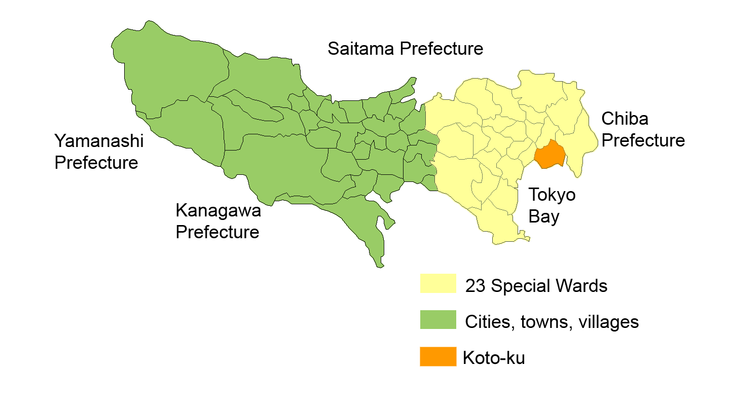
Elevation=
nihongo|Kōtō|江東区|Kōtō-ku is one of the 23 special wards ofTokyo ,Japan . As of 2008, the ward has an estimatedpopulation of 442,271 and a density of 11,070 persons per km². The total area is 39.48 km². The ward refers to itself as Kōtō City in English.Kōtō is located east of the Tokyo metropolitan center, bounded by the
Sumidagawa to the west and the Arakawa to the east. Its major districts include Kameido, Kiba, Kiyosumi, Monzen-nakachō, and Shirakawa. The newly developed waterfront area of Ariake is in Kōtō, as is part ofOdaiba (including the popular Palette Town shopping complex).Geography
Kōtō occupies a position on the waterfront of
Tokyo Bay sandwiched between the wards of Chūō and Edogawa. Its inland boundary is with Sumida. Much of the land is reclaimed, so there are few old temples or shrines.Noteworthy places in Kōtō include
*In the former ward of Fukagawa: Kiba, Fukagawa, Edagawa
*In the former ward of Jōtō: Kameido, Ōjima, Sunamachi
*On recently reclaimed land: Ariake, Yumenoshima, Tokyo Rinkai FukutoshinHistory
The western part of the ward was formerly part of Fukagawa Ward of
Tokyo City . It suffered severe damage in the Great Kantō Earthquake and was heavily bombed duringWorld War II .The special ward was founded on
March 15 ,1947 by the merger of the wards of Fukagawa and Jōtō.Transportation
Rail
* JR East
**Chūō-Sōbu Line :Kameido Station
**Keiyō Line :Etchu-jima Station ,Shiomi Station ,Shin-kiba Station
* JR Freight
**Etchu-jima Branch Line :Etchu-jima Station
*Tokyo Metro
** Tozai Line:Monzen-nakacho Station ,Kiba Station ,Toyocho Station ,Minami-sunamachi Station
** Yurakucho Line:Toyosu Station ,Tatsumi Station ,Shin-kiba Station
** Hanzōmon Line:Sumiyoshi Station ,Kiyosumi-shirakawa Station
*Tokyo Metropolitan Bureau of Transportation
**Toei Shinjuku Line :Morishita Station ,Sumiyoshi Station ,Nishi-ojima Station ,Ojima Station ,Higashi-ojima Station
**Toei Oedo Line :Morishita Station ,Kiyosumi-shirakawa Station ,Monzen-nakacho Station
*Tobu Railway
** Kameido Line:Kameido Station ,Kameido-suijin Station
*Tokyo Waterfront Area Rapid Transit
**Rinkai Line :Shin-kiba Station ,Shinonome Station ,Kokusai-tenjijo Station ,Tokyo Teleport Station
*Tokyo Waterfront New Transit Corporation
**Yurikamome :Fune-no-kagakukan Station ,Telecom Center Station ,Aomi Station ,Kokusai-tenjijo-seimon Station , Ariake Station,Ariake-tennis-no-mori Station ,Shijō-mae Station ,Shin-toyosu Station ,Toyosu Station Highway
*
Shuto Expressway
**C2 Central Loop (Itabashi JCT - Kasai JCT)
**No.7 Komatsugawa Route (Ryogoku JCT - Yagochi)
**No.9 Fukagawa Route (Hakozaki JCT - Tatsumi JCT)
**B Bayshore Route (Kawasaki-ukishima JCT - Koya)Air
*
Tokyo Heliport is in Shin-Kiba.Famous places
*
ageHa nightclub
*Kameido Tenjin Shinto Shrine
*Tomioka Hachiman Shrine
*Fukagawa Fudo-son
*Kiyosumi Garden
*Museum of Contemporary Art Tokyo
*Tokyo Big Sight (Tokyo International Exhibition Center)
*Ariake Coliseum , site ofJapan Open Tennis Championships ,All Japan Tennis Championships and so on
*Ariake Tennis Forest Park , which hasAriake Coliseum and 48 tennis courts
*Suzaki Baseball Field , site ofJapanese Baseball League games in 1930s
*Kiba Metropolitan Park
*Yumenoshima Tropical Greenhouse Dome
*Shin-Kiba 1st Ring Education
Colleges and universities
*
Tokyo University of Marine Science and Technology (Tokyo Kaiyo Daigaku, part of the national university system)Primary and secondary schools
Public elementary and middle schools are operated by the
Koto City Board of Education . Public high schools are operated by theTokyo Metropolitan Government Board of Education .
*Daisan Commercial High School [http://www.daisanshogyo-h.metro.tokyo.jp/]
*Fukagawa High School [http://www.fukagawa-h.metro.tokyo.jp/]
*Higashi High School [http://www.higashi-h.metro.tokyo.jp/]
*High School of Science and Technology [http://www.st-h.metro.tokyo.jp/]
*Johtoh High School [http://www.joto-h.metro.tokyo.jp/index.html]
*Koto Commercial High School [http://www.kotoshogyo-h.metro.tokyo.jp/]
*Oedo High School [http://www.oedo-h.metro.tokyo.jp/]
*Sumida Technical High School [http://www.sumida-th.metro.tokyo.jp/]International schools
International schools are independently owned and operated.
*K. International School Tokyo [http://www.kist.ed.jp/]Famous people
*
Shintaro Katsu , actor
*Yoshimi Iwasaki , singer
*Kaori Mochida , singer, former child actress
*Genki Sudo ,K-1 competitor
*Kaishoryu Kuniaki ,sumo wrestler
*Daisuke Matsuzaka , baseball player (competed in EdogawaLittle League )
*Miyuki Miyabe , author
*Suihō Tagawa , artist
*Ken Kutaragi ,videogame executiveister cities
As of
April 20 ,1989 , Kōtō became theSister City of Surrey,British Columbia ,Canada .ee also
References
External links
* [http://www.city.koto.lg.jp/language/lang-eng/index.html Kōtō official website] in English
Wikimedia Foundation. 2010.