- Maryland Route 193
-
Maryland Route 193
University Boulevard, Greenbelt Road 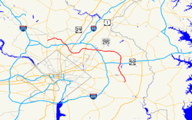
Maryland Route 193 highlighted in redRoute information Maintained by MDSHA Length: 26.07 mi[1][2] (41.96 km) Major junctions West end:  MD 185 in Kensington
 MD 97 in Wheaton
 US 29 in Silver Spring
 I-495 in Silver Spring
 MD 650 in Langley Park
 US 1 in College Park
 MD 201 in Greenbelt
 MD 295 in Greenbelt
 MD 450 in Glenn Dale
 MD 214 in Kettering
East end:  MD 202 in Greater Upper Marlboro
Highway system Maryland highway system
Interstate • US • State • Minor • Former • Turnpikes←  MD 192
MD 194  →
→Maryland Route 193 (MD 193) is a state highway in the U.S. state of Maryland. Known for most of its length as University Boulevard and Greenbelt Road, the state highway runs 26.07 mi (41.96 km) from MD 185 in Kensington east to MD 202 in Greater Upper Marlboro. MD 193 serves as a major east-west commuter route in eastern Montgomery County and northern Prince George's County, connecting Wheaton, Silver Spring, Langley Park, College Park, and Greenbelt. The state highway also provides the primary access to the University of Maryland and Goddard Space Flight Center. In central Prince George's County, MD 193 is the main north-south highway connecting Glenn Dale and Greater Upper Marlboro with the affluent suburbs of Woodmore and Kettering.
MD 193 originally consisted of Connecticut Avenue between Chevy Chase and Kensington and University Lane between Kensington and College Park. While MD 185 replaced MD 193 on the Connecticut Avenue portion in the 1970s, MD 193 grew on its eastern end by taking over the routing of MD 430 between College Park and Greenbelt and MD 199 in Glenn Dale in the early 1960s. MD 193 reached its final extent by taking over MD 556 between Glenn Dale and Greater Upper Marlboro in the late 1980s. The state highway's expansion from a two-lane road to a divided highway with four to six lanes began in the 1950s and continued through the 1990s.
Contents
Route description
Montgomery County
MD 193 begins at an acute intersection with MD 185 (Connecticut Avenue) in Kensington.[3] There is no access between southbound MD 185 and eastbound MD 193, as well as between westbound MD 193 and northbound MD 185; those movements use Perry Avenue.[3] The state highway, named University Boulevard, heads northeast as a six-lane divided highway with a speed limit of 30 mph (48 km/h) through a commercial area.[1] After leaving the town limits of Kensington, the speed limit increases to 40 mph (64 km/h) and MD 193 passes through a mix of apartment complexes and single family homes.[1] The state highway enters the commercial district of Wheaton, where the road passes the Wheaton Plaza shopping mall and intersects MD 586 (Veirs Mill Road).[3] MD 586 south is used to access the Wheaton station of the Washington Metro. MD 193 continues east through the commercial area to meet MD 97 (Georgia Avenue). There are no left turns allowed from MD 193 to MD 97; instead, the eastbound and westbound directions use Grandview Avenue and Amherst Avenue, respectively, to complete the missing movements.[3]
After passing the WTOP-FM radio transmitter, MD 193 heads southeast through suburban residential areas.[3] The state highway descends into the valley of Sligo Creek, where the highway meets the northern end of Sligo Creek Parkway and crosses the Sligo Creek Trail. MD 193 passes a cluster of high-rise apartment buildings and Northwood High School around the intersection with Arcola Avenue and turns south, passing Dennis Avenue.[3] MD 193 splits into a one-way pair upon entering the Four Corners commercial area, where the highway intersects U.S. Route 29 (US 29) and passes Montgomery Blair High School.[3] The state highway then meets the Capital Beltway at a partial cloverleaf interchange that is missing the movements between I-495 west and MD 193 west.[3] The missing movements are completed by using US 29 south of Four Corners. After crossing the Capital Beltway, MD 193 continues south through residential suburban areas of Silver Spring, intersecting Franklin Avenue. After meeting MD 320 and passing Quebec Terrace Park, the state highway turns southeast and enters an area of garden apartments and duplexes.[3] After crossing MD 195 at an oblique angle, the speed limit falls to 35 mph (56 km/h) and MD 193 enters Prince George's County.[1][3]
Prince George's County

MD 193 continues east into Langley Park, an area with multiple shopping centers, garden apartments, and heavy pedestrian cross-traffic.[3] MD 193 meets MD 650 at Takoma-Langley Crossroads, an intersection with a shopping center on all four corners.[3] The state highway continues straight southeast toward its junction with MD 212, where MD 193 turns east. After passing Lane Manor Recreation Center, the state highway leaves the commercial area and crosses Northwest Branch.[3] Here the highway reduces to four lanes and the speed limit increases to 45 mph (72 km/h).[2] MD 193 continues east through a forested area toward College Park.[3] Campus Drive continues straight toward the University of Maryland campus as well as University of Maryland University College, while MD 193 veers left and intersects Adelphi Road.[3] Movements between MD 193 east and Adelphi Road south are made via Campus Drive. After passing Adelphi Road, the state highway heads northeast past the intersection with Stadium Drive, which is used to access Byrd Stadium and the Clarice Smith Performing Arts Center. After turning east again, MD 193 intersects Paint Branch Drive, which serves the Comcast Center. The state highway passes Paint Branch Golf Course and crosses Paint Branch, after which the speed limit drops to 40 mph (64 km/h) and the highway intersects US 1 at a partial interchange.[2][3] The missing movements are made via a right-in/right-out interchange on the eastbound side just to the east of the partial interchange, and through Greenbelt Road (unsigned MD 430) just to the east of Rhode Island Avenue, which has a westbound at-grade exit and eastbound entrance.[2][3]
After passing Greenbelt Road, MD 193 expands to six lanes and its name changes to Greenbelt Road.[2] The state highway crosses CSX's Capital Subdivision, MARC's Camden Line, and the Green Line (Washington Metro) of the Washington Metro and Indian Creek, then enters a commercial area as the highway straddles the northern boundary of Berwyn Heights.[2][3] After passing Cherrywood Drive, which leads to the Greenbelt (Washington Metro) Metro station, MD 193 passes Beltway Plaza shopping mall.[3] The state highway then meets MD 201 (Kenilworth Avenue) at a diamond interchange.[3] MD 193 continues east into Greenbelt as an eight-lane divided highway with a speed limit of 45 mph (72 km/h) past Greenbelt Park until right before passing under the Capital Beltway, where the right lane eastbound exits for the southbound Baltimore-Washington Parkway.[2][3] Both directions of MD 193 access the southbound parkway via Southway, which heads north into the Greenbelt Historic District.[3] After crossing the parkway, MD 193 has an intersection with the northbound ramps to the parkway, after which the speed limit drops to 35 mph (56 km/h).[2] After passing Eleanor Roosevelt High School, the speed limit returns to 45 mph (72 km/h), the road reduces to four lanes, and the state highway passes a series of apartment complexes on the south and the campus of Goddard Space Flight Center on the north.[2][3] Beyond Goddard, MD 193 passes Good Luck Road and some more apartments and shopping centers in Glenn Dale before meeting MD 564 (Lanham Severn Road).[3]
MD 193 heads southeast from MD 564 as Glenn Dale Boulevard, a four-lane divided highway with a wide median through scattered residential subdivisions.[3] The state highway immediately crosses the Amtrak Northeast Corridor and MARC's Penn Line as well as Folly Branch.[2] MD 193 passes Marietta, a historic home and museum, before its intersection with MD 450 (Annapolis Road), where the name of the highway changes to Enterprise Road.[2] Beyond MD 450, the state highway slims down to two lanes and passes through residential subdivisions.[3] After an intersection with the old alignment, MD 953 (Glenn Dale Road), MD 193 temporarily becomes a divided highway as it passes under the US 50 freeway. The state highway enters the affluent suburb of Woodmore, where it passes the Country Club at Woodmore and Enterprise Golf Course, which features the Newton White Mansion, before intersecting Lottsford Road and Woodmore Road.[3] MD 193 continues south and temporarily expands to a four-lane divided highway with a speed limit of 30 mph (48 km/h) prior to crossing the Northeast Branch of the Western Branch of the Patuxent River and meeting MD 214 (Central Avenue) in Kettering.[2] Beyond MD 214, the state highway becomes a two-lane road with a speed limit of 35 mph (56 km/h) and changes its name to Watkins Park Drive.[2] MD 193 passes Watkins Regional Park and First Baptist Church of Glenarden before encountering Oak Grove Drive at a roundabout.[3] From there, the state highway turns southwest and meets its eastern terminus at MD 202 (Largo Road) in Greater Upper Marlboro.
History
MD 193 originally consisted of two named portions, Connecticut Avenue from Chevy Chase to Kensington and University Lane from Kensington to College Park.[4] The Connecticut Avenue segment is now MD 185; that portion's history is covered in more detail in the Maryland Route 185 article. University Lane was paved from Kensington to Wheaton and from Four Corners to MD 320 in Silver Spring by 1927.[5] The pavement extended from MD 320 to MD 212 in 1930; the segment of road on the University of Maryland campus was also paved.[6] By 1933, MD 193 was fully paved from Kensington to US 1 in College Park when the portion between MD 212 and the university was completed on a new alignment.[7]
The roads over which MD 193 would later be extended east consisted of three state highways:
- MD 430 (Greenbelt Road) was completed on a new alignment in 1942 between US 1 in College Park and MD 205 (now MD 201) in Greenbelt.[8] Greenbelt Road continued east as a county-maintained highway towards Glenn Dale.[9]
- MD 199 (Glenn Dale Road) was paved from US 50 (now MD 450) north to the Penn Line in 1927.[5] The MD 199 designation was extended north to MD 564 in 1950, then removed from the entire road in 1954.[10][11]
- MD 556 (Enterprise Road) was paved from MD 214 north to near Woodmore Road in 1933.[7] A second segment of MD 556 was signed from US 50 south to the present intersection of MD 193 and MD 953 by 1939.[4] The two segments were connected by a county-maintained segment that was brought under state control by 1946.[9] MD 556 was extended south along Enterprise Road to MD 202 in 1955.[12]
The four-lane divided bypass of the University of Maryland was started by 1955 and completed in 1956.[8][13] At that time, MD 193 turned south at the right-in/right-out ramps just east of the US 1 overpass to a right angle intersection with MD 430.[13] The four-lane divided highway was extended west from College Park in stages, reaching MD 650 in 1957, Franklin Avenue (then MD 516) in 1959, US 29 in Four Corners in 1960, and Kensington in the early 1960s.[8][14][15][16][17] MD 193's western terminus was moved from Chevy Chase to Kensington in the 1970s.[18] MD 193 was expanded to six lanes between Kensington and Langley Park beginning in 1972.[8]
Between 1962 and 1964, MD 193 was extended east as a four-lane divided highway from College Park along MD 430 and the remainder of Greenbelt Road to Glenn Dale.[8][17] The state highway then headed south along Glenn Dale Road (former MD 199) to MD 450, then south along the part of Glenn Dale Road that had never been state-maintained to an intersection with MD 556 just north of the US 50 freeway.[17] MD 193 was expanded to six lanes between MD 430 and just east of MD 201 in 1988, when the MD 201 interchange was completed.[8] The six lane section was extended to the east edge of Greenbelt in 1994.[8]
Glenn Dale Boulevard, a four-lane divided highway, was finished in 1986 when its bridge over the Penn Line was completed, replacing a grade crossing at Glenn Dale Road.[8][19] Glenn Dale Boulevard extended south to the intersection of MD 450 and MD 556. MD 193 was extended south on Glenn Dale Boulevard then replaced MD 556 on Enterprise Road south to MD 214.[19] Finally, Watkins Park Drive was built in 1988 on a new alignment, replacing Enterprise Road south of MD 214.[8] MD 193 was extended along Watkins Park Drive and replaced the remaining segment of MD 556.[20]
Junction list
County Location Mile
[1][2]Destinations Notes Montgomery 6.70 miles (10.78 km)
Kensington 0.00 MD 185 (Connecticut Avenue) – Chevy Chase, Aspen HillWestern terminus Wheaton 1.24  MD 586 (Veirs Mill Road) – Rockville
1.46 MD 97 (Georgia Avenue) – Silver Spring, Glenmont2.74 Sligo Creek Parkway – Silver Spring Silver Spring 4.32 US 29 (Colesville Road) to I-495 west – Downtown Silver Spring, Columbia4.91 I-495 (Capital Beltway) – College Park, Baltimore, Northern VirginiaI-495 Interchange 29 5.17 Franklin Avenue – Silver Spring Former MD 516 6.15  MD 320 (Piney Branch Road) – Takoma Park, Adelphi
Takoma Park 6.58  MD 195 (Carroll Avenue) – Takoma Park
Prince George's County 19.37 miles (31.17 km)
Langley Park 7.03 MD 650 (New Hampshire Avenue) – Takoma Park, White Oak7.61  MD 212 (Riggs Road) – Hyattsville, Adelphi
College Park 8.81 Campus Drive east – University of Maryland Eastbound exit, westbound entrance 8.92 Adelphi Road – Adelphi, University Park 10.79 US 1 (Baltimore Avenue) – College Park, LaurelPartial cloverleaf interchange 10.87 To US 1 north (Baltimore Avenue) – LaurelEastbound right-in, right-out interchange 11.32 Greenbelt Road to US 1 south – College ParkUnsigned MD 430; Westbound exit, eastbound entrance Greenbelt 12.53 MD 201 (Kenilworth Avenue) to I-95 / I-495 – Bladensburg, Greenbelt, BaltimoreDiamond interchange 13.01 MD 295 south (Baltimore–Washington Parkway) – WashingtonEastbound exit only 13.52 Southway north to MD 295 south (Baltimore–Washington Parkway) – Greenbelt, Washington13.85 MD 295 north (Baltimore–Washington Parkway) – BaltimoreGlenn Dale 17.10  MD 564 (Lanham Severn Road) – Lanham, Bowie
19.44 MD 450 (Annapolis Road) – Lanham, Bowie20.27  MD 953 (Glenn Dale Road) – Glenn Dale
Kettering 24.01 MD 214 (Central Avenue) – Largo, BowieGreater Upper Marlboro 25.77 Oak Grove Road Roundabout 26.07 MD 202 (Largo Road) – Largo, Upper MarlboroEastern terminus References
- ^ a b c d e "Highway Location Reference: Montgomery County" (PDF). Maryland State Highway Administration. 2008. http://apps.roads.maryland.gov/KeepingCurrent/performTrafficStudies/dataAndStats/hwyLocationRef/2008_hlr_all/co15.pdf. Retrieved 2010-02-09.
- ^ a b c d e f g h i j k l m n "Highway Location Reference: Prince George's County" (PDF). Maryland State Highway Administration. 2008. http://apps.roads.maryland.gov/KeepingCurrent/performTrafficStudies/dataAndStats/hwyLocationRef/2008_hlr_all/co16.pdf. Retrieved 2010-02-09.
- ^ a b c d e f g h i j k l m n o p q r s t u v w x y z aa ab Google, Inc. Google Maps – Maryland Route 193 (Map). Cartography by Google, Inc. http://maps.google.com/maps?f=d&source=s_d&saddr=md-193+and+connecticut+ave+north+kensington,+md&daddr=university+blvd+w+and+sligo+creek+parkway+silver+spring,+md+to:md-193+and+us+29+silver+spring,+md+to:md-193+and+adelphi+rd+college+park,+md+to:md-193+and+good+luck+rd+glenn+dale,+md+to:md-193+and+md-202+upper+marlboro,+md&hl=en&geocode=FYCSUwIdyu1n-ylPM8uewc63iTHtWWkmjt1yoQ%3BFVumUwIdnZto-yndxKKqbc-3iTHeYJvyohRFvw%3BFUpMUwIdIwRp-ymjMsIw-sW3iTFGs9tnzBWaTQ%3BFdriUgIddb9p-ykLfu37jsa3iTG1QYKEyBkdKg%3BFbDzUgIdtpNr-ylvdOFnA8K3iTGqfG6fOkCYqA%3BFeAqUQIdS11s-ymvNNG-HpW3iTFfKG09LWkt3Q&mra=ls&sll=38.911339,-76.824303&sspn=0.122085,0.308647&ie=UTF8&t=h&z=11. Retrieved 2010-02-10.
- ^ a b Maryland State Roads Commission (PDF). Map of Maryland (Map) (1939 ed.). http://commons.wikimedia.org/wiki/File:Maryland_State_Highway_Map_-_1939.pdf. Retrieved 2010-02-10.
- ^ a b Maryland State Highway Administration (JPG). Map of Maryland (Map) (1927 ed.). http://www.mdhighwaycentennial.com/images/template/gallery/maps/1927SIDE1.jpg. Retrieved 2010-02-10.
- ^ Maryland State Roads Commission (JPG). Map of Maryland (Map) (1930 ed.). http://commons.wikimedia.org/wiki/File:Maryland_State_Highway_Map_-_1930.jpg. Retrieved 2010-02-10.
- ^ a b Maryland State Roads Commission (PDF). Map of Maryland (Map) (1933 ed.). http://commons.wikimedia.org/wiki/File:Maryland_State_Highway_Map_-_1933.pdf. Retrieved 2010-02-10.
- ^ a b c d e f g h i Svirsky, Alexander. "National Bridge Inventory Database". http://nationalbridges.com/. Retrieved 2010-02-10.
- ^ a b Maryland State Roads Commission (PDF). Map of Maryland (Map) (1946 ed.). http://commons.wikimedia.org/wiki/File:Maryland_State_Highway_Map_-_1946.pdf. Retrieved 2010-02-10.
- ^ Maryland State Roads Commission (PDF). Map of Maryland (Map) (1950 ed.). http://commons.wikimedia.org/wiki/File:Maryland_State_Highway_Map_-_1950.pdf. Retrieved 2010-02-10.
- ^ Maryland State Roads Commission (PDF). Map of Maryland (Map) (1954 ed.). http://commons.wikimedia.org/wiki/File:Maryland_State_Highway_Map_-_1954.pdf. Retrieved 2010-02-10.
- ^ Maryland State Roads Commission (PDF). Map of Maryland (Map) (1955 ed.). http://commons.wikimedia.org/wiki/File:Maryland_State_Highway_Map_-_1955.pdf. Retrieved 2010-02-10.
- ^ a b Maryland State Roads Commission (PDF). Map of Maryland (Map) (1956 ed.). http://commons.wikimedia.org/wiki/File:Maryland_State_Highway_Map_-_1956.pdf. Retrieved 2010-02-10.
- ^ Maryland State Roads Commission (PDF). Map of Maryland (Map) (1957 ed.). http://commons.wikimedia.org/wiki/File:Maryland_State_Highway_Map_-_1957.pdf. Retrieved 2010-02-10.
- ^ Maryland State Roads Commission (PDF). Map of Maryland (Map) (1959 ed.). http://commons.wikimedia.org/wiki/File:Maryland_State_Highway_Map_-_1959.pdf. Retrieved 2010-02-10.
- ^ Maryland State Roads Commission (PDF). Map of Maryland (Map) (1960 ed.). http://commons.wikimedia.org/wiki/File:Maryland_State_Highway_Map_-_1960.pdf. Retrieved 2010-02-10.
- ^ a b c Maryland State Roads Commission (PDF). Map of Maryland (Map) (1970 ed.). http://commons.wikimedia.org/wiki/File:Maryland_State_Highway_Map_-_1970.pdf. Retrieved 2010-02-10.
- ^ Maryland State Roads Commission (PDF). Map of Maryland (Map) (1980 ed.). http://commons.wikimedia.org/wiki/File:Maryland_State_Highway_Map_-_1980.pdf. Retrieved 2010-02-10.
- ^ a b "Traffic Volume Map" (PDF). Maryland State Highway Administration. 1986. http://www.marylandroads.com/Traffic_Volume_Maps/86_Traffic_Volume_Maps.pdf. Retrieved 2010-02-20.
- ^ "Traffic Volume Map" (PDF). Maryland State Highway Administration. 1988. http://www.marylandroads.com/Traffic_Volume_Maps/88_Traffic_Volume_Maps.pdf. Retrieved 2010-02-10.
External links
Roads in Montgomery County, Maryland Maryland State Highways 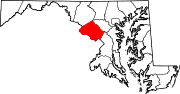
U.S. Routes Interstate Highways Roads by name Cabin John Parkway · Clara Barton Parkway · Cherry Hill Road · Connecticut Avenue · Georgia Avenue · Montrose Road · New Hampshire Avenue · Randolph Road · Sligo Creek Parkway · Wisconsin Avenue · 16th StreetRoads in Prince George's County, Maryland Maryland State Highways 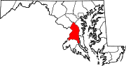
U.S. Routes Interstate Highways Roads by name Categories:- State highways in Maryland
- Roads in Montgomery County, Maryland
- Roads in Prince George's County, Maryland


Wikimedia Foundation. 2010.