- Humberside
-
For other uses, see Humberside Collegiate Institute.
Humberside Motto: United we Flourish 
Humberside within England in 1991Geography Status Non-metropolitan county 1974 area 867,755 acres (3,511.68 km2)[1] HQ Beverley ONS code 27 History Origin Humber estuary and environs Created 1974 Abolished 1996 Succeeded by East Riding of Yorkshire
Hull
North Lincolnshire
North East LincolnshireDemography 1973 population 847,230[2] 1981 population 843,280 1991 population 858,040 Politics Governance Humberside County Council 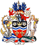
Coat of arms of the county councilHumberside (
 /ˈhʌmbərsaɪd/) was a non-metropolitan and ceremonial county in Northern England from 1 April 1974 until 1 April 1996. It was composed of land from either side of the Humber Estuary, created from portions of the East and West ridings of Yorkshire and parts of Lindsey, Lincolnshire. The county council's headquarters were County Hall at Beverley, inherited from the East Riding, and its largest settlement and only city was Kingston upon Hull. The county stretched from Wold Newton in its northern tip, to a different Wold Newton at its most southern point.
It bordered North Yorkshire to the north and west, South Yorkshire and Nottinghamshire to the south-west, and Lincolnshire to the south. It faced east towards the North Sea. It was abolished on 1 April 1996, with four unitary authorities being formed: North Lincolnshire, North East Lincolnshire, Kingston upon Hull and East Riding of Yorkshire.[3] The name has continued in use as a geographic term and in the names of institutions such as Humberside Police and Humberside Fire Service.
Contents
Name
The name "Humberside" was used as an informal name and geographical term for the area surrounding the Humber prior to the creation of the county.[4] By the twentieth century the industrial development of both sides of the Humber Estuary was becoming increasingly integrated and "Humberside" was being widely applied to the ports of Hull, Grimsby and Goole and their hinterland.[5] The use of the term to unify the two sides of the river was also driven by the desire of the local authorities of the area to promote the construction of a suspension bridge.[6]
It was first adopted as an official term in 1964 when the planning region of Yorkshire and Humberside was created consisting of the East, West Ridings of Yorkshire and Parts of Lindsey from Lincolnshire.[7] From that time on the Humberside name was actively used to market the area.[8] In 1971 the newly-launched local BBC radio station was named Radio Humberside.
Formation
It was created by the Local Government Act 1972 on 1 April 1974. It covered the former county boroughs of Grimsby and Kingston upon Hull. From Lindsey it incorporated the boroughs of Cleethorpes, Scunthorpe the urban districts of Barton-upon-Humber and Brigg, and the rural districts of Glanford Brigg, Grimsby and Isle of Axholme. From the East Riding it took the boroughs of Beverley, Bridlington, Hedon the urban districts of Driffield, Haltemprice, Hornsea and Withernsea, and the rural districts of Beverley, Bridlington (part), Driffield, Holderness, Howden, Pocklington. From the West Riding it took both the borough of Goole and the rural district of Goole.[9]
In the Redcliffe-Maud Report no directly-analogous area had been proposed, with the part north of the Humber consisting of one unitary authority, and the part south of it constituting another. The White Paper as proposed did not include a cross-Humber authority, either, with the northern part forming an "East Yorkshire" area and the southern area forming a Lincolnshire area. Humberside finally emerged in the Local Government Bill as introduced to Parliament, which also gave it its name for the first time.[10]
Paul Bryan, the MP for Howden moved an amendment to the Bill that would have created a county of East Yorkshire, covering the rural area of northern Humberside along with Selby and York (and also Flaxton Rural District), leaving a Humberside including Haltemprice, Hull, Grimsby, Scunthorpe and Goole, whilst Cleethorpes and Grimsby Rural District would have been kept in Lincolnshire. The amendment was rejected by the House.[11]
At this time, there was very little connecting its two parts, aside from ferries and a circuitous journey via Goole (a road journey from Grimsby to Beverley, the headquarters, being something just under 100 miles). It was promised by the government that the Humber Bridge would make it a more viable unit. By 1975 the bridge was planned to open in 1977.[12] It finally opened on 24 June 1981, providing a permanent link between North and South (and cutting the journey from Grimsby to Beverley to a mere 30 or so miles), but did not secure Humberside's future.
Districts
The county was divided into nine non-metropolitan districts:

- North Wolds renamed East Yorkshire in 1981
- Holderness
- Kingston upon Hull
- Beverley: renamed East Yorkshire Borough of Beverley in 1981
- Boothferry
- Scunthorpe
- Glanford
- Grimsby renamed Great Grimsby in 1979
- Cleethorpes
Coat of arms
Humberside County Council held a competition to design a coat of arms for the new county. The winning design was by a Mr E H Cook from Thorngumbald and letters patent granting the arms were issued by the College of Arms on 28 July 1976.
The shield was an heraldic map of the county: at the top was a gold ducal coronet from the arms of the city of Hull between two white Yorkshire roses, while at the bottom of the shield were two gold fleurs-de-lis representing Lincolnshire. Across the centre of the shield was a blue and silver wave for the River Humber.
The crest was a blue eagle taken from the East Riding County Council arms rising phoenix-like from flames, suggesting a new authority emerging from the ashes of the old. The eagle's wings bore gold droplets standing for North Sea Oil and held a sword in the beak for the Scunthorpe steel industry.
The supporters on either side were: a silver dolphin bearing a terrestrial globe and supporting an anchor for worldwide trade; and Ceres goddess of harvest, for the county's agriculture. They stood upon a compartment depicting the countryside and coastline of Humberside.
The blazon or technical description of the arms was:
Per fess Sable and Gules on a Fess wavy Argent between in chief a Coronet Or between two Roses Argent barbed and seeded proper and in base two Fleurs de Lis Or a Bar wavy Azure and for a Crest on a Wreath Or and Gules rising from Flames proper a demi-Eagle Azure Goutté d'Or armed also Gold holding in the beak a Sword point downwards proper hilt and pommel Or.
And for Supporters on the dexter a Dolphin Argent finned Or charged on the shoulder with a Terrestrial Globe Azure the land masses Or supporting an Anchor proper and on the sinister a Female Figure habited representing Ceres with Cornucopia all proper upon a Compartment per pale Water barry wavy Azure and Argent and a Grassy Field proper.[13]The motto was United we Flourish.[14]
On the abolition of the county council in 1996 the arms became obsolete. However, the Humberside Fire and Rescue Service continue to use a version of the shield as their badge.[15]
Abolition
Humberside was not well-loved, and to quote James Cran (MP for Beverley), "almost the day after the decision was announced, a campaign began to have Humberside abolished".[16] North Wolds Borough Council changed its name to East Yorkshire Borough Council, likely to emphasise this, and Beverley Borough Council formally included 'East Yorkshire' in its name. According to Cran there was a campaign in 1987 to get Humberside County Council to change its name to something like 'East Yorkshire and North Lincolnshire'.
This attitude was reported as less common in the port towns of the county - The Times noted that Hull and Grimsby "regard the advantages of unification as an exciting prospect".[17]
The Local Government Boundary Commission for England advised the Secretary of State for the Environment, Michael Heseltine, in 1982 that "a review of the Humberside county boundary [was] warranted".[18] The Local Government Boundary Commission reviewed the existence of Humberside from 1985 to 1988, but found that "that Humberside County Council could not be shown to have failed". The Secretary of State for the Environment called for a further review in 1989, which ultimately resulted in a proposal made in November 1990, to transfer the four districts south of the Humber to the non-metropolitan county of Lincolnshire (which would have left the remaining part north of the Humber free to change its name to include Yorkshire).[19] A report prepared for the LGBC in 1990 indicated that 63% of respondents thought that the creation of Humberside was "bad", 14% that it was "good")[20]
However, before this could be implemented, a general local government review for England was announced. This was being conducted with an eye to creating unitary authorities, and Humberside was one of the areas that the Commission was expecting "early wins" in, and was in the first tranche of reviews. The Commission recommended it and its districts be abolished and replaced with four unitary authorities, which the government accepted. The Order to do so was debated in the House of Commons on 28 February 1995, and in the House of Lords on 6 March 1995, and came into effect on 1 April 1996.[21]
This resulted in four successor unitary authorities:
- Kingston upon Hull
- East Riding of Yorkshire: Beverley, East Yorkshire, Holderness, and northern Boothferry
- North Lincolnshire: Glanford, Scunthorpe and southern Boothferry
- North East Lincolnshire: Great Grimsby, Cleethorpes
There was some debate as to the fate of the Goole area (historically part of the West Riding). The Secretary of State (John Gummer) originally proposed that Goole should be "incorporated in Selby of North Yorkshire",[22] but ultimately it was decided to associate it with the rest of North Humberside.
There were also questions raised as to whether the boundaries of Hull should be expanded from their present boundaries (which had been set many decades ago and not altered, despite continuous urbanisation outside these borders in the former urban district of Haltemprice).
Michael Brown the Conservative MP for Brigg and Cleethorpes, was particularly vociferous in support of the Order, saying 'I want to see the word "Humberside" expunged from the English language' in the debate regarding its abolition.[23]
There were to be heard few voices in its defence. Elliot Morley, Labour MP for Glanford and Scunthorpe claimed that 'young people who were born in Humberside and have an affinity with Humberside identify with it', although he agreed that the council was a 'flawed idea'.
The office of Lord Lieutenant of Humberside was also abolished. The Yorkshire part became the ceremonial county of the East Riding of Yorkshire (which includes Hull); the Lincolnshire part reverted to Lincolnshire for ceremonial purposes. The whole of the area once covered by the former non-metropolitan county of Humberside, including the Lincolnshire parts, is part of the government office region of Yorkshire and the Humber (originally Yorkshire and Humberside).
Postal counties
The Royal Mail did not adopt Humberside as a postal county, instead dividing the area into North Humberside and South Humberside for purposes of directing mail with effect from 1 July 1975.[24] Counties ceased to form part of addresses in 1996.[25] Under the Royal Mail's flexible addressing policy, in force since that date, users can choose to add a county to an address as long as the post town and postcode are included. The policy allows for the use of either the "former postal", "traditional" or "administrative" county. The Postcode Address File Code of Practice does not allow for changes in the former postal county.[26] In 2008 the Postal Services Commission (Postcomm) announced that it was holding a public consultation into the code. Accordingly, local council leaders and members of parliament asked that Postcomm recommend the deletion of North and South Humberside from postal databases. The recommendations were expected to be issued in late summer 2009[27] and a decision made by the end of the year.[28]
Legacy
Despite the abolition of the county, the term 'Humberside' has not fallen out of use as a general geographic designation. There is still a Humberside Police, a Humberside Airport (roughly halfway between Scunthorpe and Grimsby), a Humberside Fire Service and BBC Radio Humberside (founded in 1971).
References
- ^ Local government in England and Wales: A Guide to the New System. London: HMSO. 1974. p. 60. ISBN 0117508470.
- ^ Registrar General's annual estimated figure mid 1973
- ^ "The Humberside (Structural Change) Order 1995". http://www.opsi.gov.uk/si/si1995/Uksi_19950600_en_1.htm.
- ^ Woolridge, S W; Gordon East, W (1957). The Spirit and Purpose of Geography. London: Hutchinson. pp. 92–93.
- ^ "Industries Of Humberside, A Special Survey, Trade And Engineering". The Times: p. 6. 2 October 1935.
- ^ "Humber Bridge Plan Revived. Design Expected Next Month". The Times: p. 3. 20 August 1955.
- ^ "Six Regions Named For Planning". The Times: p. 12. 11 December 1964.
- ^ "The Times Supplement on Humberside". The Times. 26 April 1965.
- ^ Local Government Act 1972
- ^ Humberside joins new county ranks. The Times. 5 November 1971.
- ^ Parliamentary Debates, House of Commons, 6 July 1972, column 1047.
- ^ Humberside: Bridge seen as symbol of unity. The Times. 7 April 1975.
- ^ Humberside (obsolete) (Civic Heraldry of England and Wales), accessed 30 August 2007
- ^ Humberside, The Times, 15 July 1976.
- ^ An Introduction To HFRS, accessed 30 August 2007
- ^ Parliamentary Debates, House of Commons, 26 May 1993, column 491.
- ^ White Rose ties hold fast despite amputations and shake-ups of boundaries. The Times, 1 April 1974.
- ^ Humberside split looks more likely. The Times. 5 October 1982
- ^ Humberside: study of attitudes and preferences 1989-1990: Aim and purpose
- ^ Humberside: study of attitudes and preferences 1989-1990, page 37
- ^ Parliamentary Debates, House of Lords, 6 March 1995, column 68.
- ^ Parliamentary Debates, House of Commons, 25 October 1994, column 537.
- ^ Parliamentary Debates, House of Commons, 28 February 1995, column 924.
- ^ "Local Government Reorganisation and Postal Addresses". Local Government in England and Wales: A Guide to the New System. HMSO. 1974. p. 185. ISBN 0117508470.
- ^ PAF Digest Issue 6.0PDF
- ^ Royal Mail, Postcode Address File Code of PracticePDF, (2004)
- ^ "MPs and Council Leaders write to Postcomm about Humberside Postal Address removal". Driffield Times and Post. 30 June 2009. http://www.driffieldtoday.co.uk/nafferton/MPs-and-Council-Leaders-write.5414928.jp. Retrieved 8 July 2009.
- ^ "Royal Mail to decide on future of Humberside". thisishullandeastriding.co.uk. 18 November 2009. http://www.thisishullandeastriding.co.uk/news/Royal-Mail-decide-future-Humberside/article-1524488-detail/article.html. Retrieved 10 December 2009.
External links
Categories:- Humberside
- History of Lincolnshire
- History of the East Riding of Yorkshire
- Counties of England established in 1974
- Counties of England disestablished in 1996

Wikimedia Foundation. 2010.