Chapada dos Guimarães National Park
- Chapada dos Guimarães National Park
-
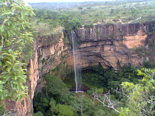
The Chapada dos Guimarães National Park (Parque Nacional da Chapada dos Guimarães in Portuguese) is a national park in the Brazilian state of Mato Grosso. It is located between 15°10'- 15º30' S and 55°40' - 56°00' W.
Chapada is a Brazilian word that means a region of steep cliffs, usually at the edge of a plateau. The Chapada dos Guimarães edge is visible in this satellite photo (Google).
The geographical center of South America is located in the Park.
| v · d · eProtected areas of Brazil |
|
| National parks |
|
 |
|
| Biological reserves |
|
|
| Ecological reserves |
|
|
| Ecological stations |
|
|
Environmental
protection areas |
|
|
Coordinates: 20°15′S 46°30′W / 20.25°S 46.5°W / -20.25; -46.5
Categories:
- Brazil geography stubs
- Brazilian protected area stubs
- National parks of Brazil
Wikimedia Foundation.
2010.
Look at other dictionaries:
Chapada dos Veadeiros National Park — Cerrado Protected Areas: Chapada dos Veadeiros and Emas National Parks * UNESCO World Heritage Site … Wikipedia
Chapada das Mesas National Park — IUCN Category II (National Park) Morro do Chapéu. While this mountain is not inside the park, it is one of the … Wikipedia
Chapada Diamantina National Park — IUCN Category II (National Park) … Wikipedia
Tumucumaque National Park — IUCN Category II (National Park) … Wikipedia
Nascentes do Rio Parnaíba National Park — is a national park of Brazil. v · … Wikipedia
List of national parks of Brazil — The system of national parks in Brazil started in 1937 with the creation of Itatiaia National Park. Another two national parks have been created in 1939, and after a period of 20 years, the program of park creation has been restarted. Since than… … Wikipedia
Serra dos Órgãos — National Park IUCN Category II (National Park) God s Finger Rock: The most famous of all the rock formations in the park … Wikipedia
Mato Grosso — State of Mato Grosso State Flag … Wikipedia
Pousada Luar do Oeste — (Chapada dos Guimarães,Бразилия) Категория отеля: Адрес: Rua Penn Gomes, 523 … Каталог отелей
Central-West Region, Brazil — Infobox Brazilian Region name = Central West states = BFD, GO, MT and MS map localization = Brazil Region CentroOeste.svg area total = 1.606.371,5 area rank = 2 water pc = pop estimate = 13,269,517 pop estimate year = 2006 pop estimate rank = 5… … Wikipedia