- Maryland Route 147
-
Maryland Route 147
Harford Road 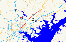
Maryland Route 147 highlighted in redRoute information Maintained by MDSHA and Baltimore DOT Length: 18.81 mi[1][2][3] (30.27 km) Major junctions South end: 


 US 1 / US 40 Truck in Baltimore
 MD 542 in Baltimore
 MD 41 in Baltimore
 I-695 in Parkville
 MD 152 in Benson
North end:  US 1 / US 1 Bus. in Benson
Location Counties: Baltimore City, Baltimore, Harford Highway system Maryland highway system
Interstate • US • State • Minor • Former • Turnpikes←  MD 146
MD 149  →
→Maryland Route 147 (MD 147) is a state highway in the U.S. state of Maryland. Known as Harford Road, the state highway runs 18.81 miles (30.27 km) from U.S. Route 1 (US 1) in Baltimore north to US 1 and US 1 Business in Benson. MD 147 is an alternate route to US 1 between Baltimore and Bel Air, the county seat of Harford County. The state highway is the main street of several neighborhoods in Northeast Baltimore and the Baltimore County suburbs of Parkville and Carney. MD 147 is maintained by the Maryland State Highway Administration in Baltimore and Harford counties and by the Baltimore City Department of Transportation within the city. Harford Road was a pair of turnpikes before the Baltimore–Carney portion of the highway was designated one of the original state roads. The Baltimore County section of MD 147 was constructed in the early 1910s and widened multiple times in the late 1920s and 1930s. The section of the state highway in Harford County was built in the late 1920s.
Contents
Route description
MD 147 begins at an intersection with US 1 (North Avenue) in Baltimore. The south leg of the intersection is one-way northbound Harford Avenue; southbound Harford Avenue toward Downtown Baltimore is accessed via southbound Aisquith a few blocks to the west. MD 147 heads northeast from US 1 as a five-lane road (three lanes northbound and two lanes southbound) that crosses over CSX's Baltimore Terminal Subdivision. The state highway passes along the western edge of Clifton Park, where the highway meets the southern ends of MD 542 (The Alameda) and MD 41 (Hillen Road). Within the Mayfield neighborhood, MD 147 passes by Lake Montebello and through Herring Run Park, where the highway crosses the namesake stream. Beyond Argonne Drive, the state highway expands to six lanes and passes through Lauraville, where the highway intersects Cold Spring Lane and Moravia Road. MD 147 reduces to four lanes and intersects Northern Parkway and the southern end of Old Harford Road in Hamilton before leaving the independent city of Baltimore.[1][4] MD 147 continues as the main street of Parkville, where the highway reduces to two travel lanes just north of Taylor Avenue. The state highway becomes four lanes again at Putty Hill Avenue and meets Interstate 695 (Baltimore Beltway) at a cloverleaf interchange.[2][4]
Outside of the Beltway, MD 147 gains a center turn lane through its intersection with Joppa Road in Carney, north of which the road reduces to two lanes. North of Cub Hill Road in the community of Cub Hill, the state highway leaves the suburban area and enters Gunpowder Falls State Park. MD 147 descends to Gunpowder Falls and makes a sharp curve to the east immediately north of the bridge over the stream. The state highway follows Gunpowder Falls and has a curvaceous ascent from the river valley before the roadway straightens out to pass through farmland with scattered subdivisions. MD 147 crosses Long Green Creek and has a sharp S-curve around a hill before intersecting Glen Arm Road. The state highway continues through the community of Fork, at the center of which the highway meets Fork Road and Sunshine Avenue. East of Fork, MD 147 descends into the valley of Little Gunpowder Falls, which forms the Baltimore–Harford county line.[2][4] The state highway continues northeast and crosses Rocky Branch before its intersection with MD 152 (Fallston Road). MD 147 heads into the community of Benson, the site of its northern terminus at a four-way intersection with US 1 and US 1 Business. US 1 heads north as the Bel Air Bypass and south as Belair Road, while US 1 Business heads east on Belair Road into the town of Bel Air.[3][4]
History
MD 147's predecessor route was followed by a pair of turnpikes in the 19th century: the Baltimore and Harford Turnpike from Baltimore to the county line at Little Gunpowder Falls, and the Harford Turnpike from there to the Baltimore and Bel Air Turnpike at the spot 2.5 miles (4.0 km) west of Bel Air that became the community of Benson.[5] The portion of Harford Road from North Avenue in Baltimore to Cub Hill was designated one of the original state roads by the Maryland State Roads Commission in 1909.[6] The proposed state road continued along what are today a series of county routes: Cub Hill Road, Glen Arm Road, and Manor Road to its intersection with Long Green Road in the community of Unionville or Long Green.[6][7] Harford Road was under construction by 1911 from North Avenue to Taylor Avenue and completed in 1912.[7][8] From North Avenue to the old city limits near Lake Montebello, Harford Road was reconstructed with a 50-foot (15 m) vitrified brick surface. From the city limits to Taylor Avenue, the highway was built with a 15-to-18-foot (4.6 to 5.5 m) wide tarred macadam surface.[7]
The old turnpike along what is now Harford Road was resurfaced from Taylor Avenue northeast to Little Gunpowder Falls by 1915.[7] The Harford County portion of Harford Road was reconstructed starting in 1926.[9] The highway was completed as a macadam road from US 1 in Benson west to Rocky Branch in 1927.[10] The remainder of Harford Road south to Little Gunpowder Falls was built as a concrete road in 1928.[11] By 1930, the portion of Harford Road in Baltimore city and county was widened to a width of 20 feet (6.1 m).[12] Harford Road was marked as MD 147 by 1933.[13] Between 1936 and 1938, the tracks of a defunct interurban were removed and the space used to widen MD 147 to a width of 46 feet (14 m) from the Baltimore city line to Carney.[14][15] That portion of MD 147 was widened again with the addition of a 7-foot (2.1 m) wide concrete shoulder around 1940.[16]
Junction list
County Location Mile
[1][2]
[3]Destinations Notes Baltimore City 0.00
US 1 / US 40 Truck (North Avenue)Southern terminus 0.80 MD 542 north (The Alameda)0.96 MD 41 north (Hillen Road)2.76 Cold Spring Lane west / Moravia Road south 4.44 Northern Parkway Baltimore Parkville 6.53 I-695 (Baltimore Beltway) – Essex, TowsonI-695 Exit 31 Carney 7.12 Joppa Road Harford Benson 17.72 MD 152 (Fallston Road) – Fallston, Joppatowne18.81 US 1 (Bel Air Bypass) / US 1 Bus. (Belair Road) – Bel AirNorthern terminus 1.000 mi = 1.609 km; 1.000 km = 0.621 mi References
- ^ a b c "Highway Location Reference: Baltimore City" (PDF). Maryland State Highway Administration. 2005. http://www.roads.maryland.gov/Location/2005_BALTIMORECITY.pdf. Retrieved 2011-07-15.
- ^ a b c d "Highway Location Reference: Baltimore County" (PDF). Maryland State Highway Administration. 2010. http://www.roads.maryland.gov/Location/2010_BALTIMORE.pdf. Retrieved 2011-07-15.
- ^ a b c "Highway Location Reference: Harford County" (PDF). Maryland State Highway Administration. 2010. http://www.roads.maryland.gov/Location/2010_HARFORD.pdf. Retrieved 2011-07-15.
- ^ a b c d Google, Inc. Google Maps – Maryland Route 147 (Map). Cartography by Google, Inc. http://maps.google.com/maps?saddr=E+North+Ave&daddr=Harford+Rd+to:MD-147+N%2FHarford+Rd&hl=en&ll=39.410733,-76.490936&spn=0.250931,0.617294&sll=39.5051,-76.384678&sspn=0.015662,0.038581&geocode=FVfaVwIdpy9v-w%3BFeRZWQIdJYJw-w%3BFYrXWgIdVoJy-w&mra=ls&t=h&z=11. Retrieved 2011-07-15.
- ^ Clark, William Bullock (1899). Report on the Highways of Maryland. Baltimore: Maryland Geological Survey. pp. 218, 237. http://books.google.com/books?id=b9l9AAAAIAAJ&printsec=frontcover#v=onepage&q&f=false. Retrieved 2011-07-17.
- ^ a b Maryland Geological Survey. Map of Maryland (Map) (1910 ed.).
- ^ a b c d Report of the State Roads Commission of Maryland (1912–1915 ed.). Baltimore: Maryland State Roads Commission. 1916-05. pp. 54, 116, 122. http://www.archive.org/details/annualreportsofs1912mary. Retrieved 2011-07-17.
- ^ Maryland Geological Survey. Map of Maryland: Showing State Road System and State Aid Roads Completed or Under Construction December 31, 1911 (Map) (1911 ed.).
- ^ Report of the State Roads Commission of Maryland (1924–1926 ed.). Baltimore: Maryland State Roads Commission. 1927-01. http://www.archive.org/details/annualreportsofs1924mary. Retrieved 2011-07-17.
- ^ Maryland Geological Survey. Map of Maryland: Showing State Road System and State Aid Roads (Map) (1927 ed.).
- ^ Maryland Geological Survey. Map of Maryland: Showing State Road System and State Aid Roads (Map) (1928 ed.).
- ^ Report of the State Roads Commission of Maryland (1927–1930 ed.). Baltimore: Maryland State Roads Commission. 1930-10-01. p. 82. http://www.archive.org/details/reportofstateroa1927mary. Retrieved 2011-07-17.
- ^ Maryland Geological Survey. Map of Maryland Showing State Road System: State Aid Roads and Improved County Road Connections (Map) (1933 ed.).
- ^ Report of the State Roads Commission of Maryland (1935–1936 ed.). Baltimore: Maryland State Roads Commission. 1936-12-04. p. 4. http://www.archive.org/details/reportofstateroa1935mary. Retrieved 2011-07-17.
- ^ Report of the State Roads Commission of Maryland (1937–1938 ed.). Baltimore: Maryland State Roads Commission. 1939-03-04. p. 115. http://www.archive.org/details/reportofstateroa1937mary. Retrieved 2011-07-17.
- ^ Report of the State Roads Commission of Maryland (1939–1940 ed.). Baltimore: Maryland State Roads Commission. 1941-03-15. p. 65. http://www.archive.org/details/reportofstateroa1939mary. Retrieved 2011-07-17.
External links
Roads in Baltimore, Maryland State highways 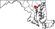
U.S. Highways Interstate Highways Roads in Baltimore County, Maryland State highways 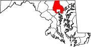
U.S. Highways Interstate Highways Roads in Harford County, Maryland State highways 
U.S. Highways Interstate Highways Categories:- State highways in Maryland
- Roads in Baltimore, Maryland
- Roads in Baltimore County, Maryland
- Roads in Harford County, Maryland


Wikimedia Foundation. 2010.