- Vistula River
Infobox_River | river_name = Vistula River
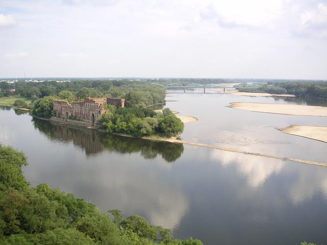
caption = Confluence of theNarew and the Vistula at Modlin
origin =Barania Góra ,Silesian Beskids
mouth =Gdańsk Bay ,Baltic Sea
basin_countries =Poland ,Ukraine ,Belarus ,Slovakia
length = 1,047 km (651 mi)
elevation = 1,106 m (3,629 ft)
discharge = 1,080 m³/s (at mouth)
watershed = 194,424 km²; (75,067 mi²)The Vistula ( _pl. Wisła; _de. Weichsel; _cz. Visla), is the longest river in
Poland at 1,047 km (678 miles) in length. It drains an area of 194,424 km² (75,067 sq. miles), of which 168,699 km² (65,135 sq. miles) lies within Poland (over half the area of the country) [http://www.stat.gov.pl/opracowania_zbiorcze/maly_rocznik_stat/2005/01_war_nat_i_och_sro.pdf] ] .The Vistula has its source in the south of the country, at
Barania Góra (1220 m high) in theSilesian Beskids (western part ofCarpathian Mountains ) where it starts with the White Little Vistula ("Biała Wisełka") and the Black Little Vistula ("Czarna Wisełka"). It then continues to flow over the vast Polish plains, passing several large Polish cities along its way, includingKraków ,Sandomierz ,Warsaw ,Płock ,Włocławek ,Toruń ,Bydgoszcz ,Świecie ,Grudziądz ,Tczew andGdańsk . With a delta and several branches (Leniwka ,Przekop ,Śmiała Wisła ,Martwa Wisła ,Nogat andSzkarpawa ) it empties into theVistula Lagoon , or directly into theGdańsk Bay of theBaltic Sea .Origins of the name Vistula
It is not known whether the root of the name "Vistula" is Indo-European or
pre-Indo-European . Thediminutive endings -ila, -ula, were used in many Indo-European language groups, among them Germanic (seeAttila , a "little father" in Gothic) but also in Latin (see Ursula, a "little female bear") which makes it difficult to establish its origin in the Vistula name. The name was first recorded by Pliny in AD 77 in his "Natural History". He uses Vistula (4.52, 4.89) with an alternative spelling, Vistillus (3.06). The Vistula River ran into theMare Suebicum , which is today known as the Baltic Sea.In writing about the Vistula River and its peoples,
Ptolemy uses the Greek spelling, "Ouistoula". Other ancient sources spell it "Istula". Pomponius Mela refers to the "Visula" (Book 3) and Ammianus Marcellinus to the "Bisula" (Book 22), both of which names lack the -t-. The definitive reference is probably Jordanes (Getica 5 & 17), who uses "Viscla". The Anglo-Saxon poemWidsith refers to it as the "Wistla".For centuries, the river was well-known in Germany and surrounding countries by the German name "Weichsel" (in medieval German documents spelled "Wissel", "Wixel" etc.). The most recent glaciations of the Pleistocene epoch, which ended around 10,000 BCE, is called
Weichsel glaciation in regard to northern central Europe.The Russian tsarist administration called the Kingdom of Poland the "Vistula province" after the
January Uprising , from 1867 to 1917.History
Ancient settlement
In the millennium before the birth of Christ, the Vistula basin was settled by Germanic tribes, most notably the
Suebi andBurgundians , and around the delta itself by the Eastern GermanicGoths (see alsoGothiscandza ,Oksywie culture ,Wielbark culture ). The Vistula region, along with the lands of theRhine ,Danube ,Elbe , andOder , came to be known asMagna Germania by the first century AD. The Lower Vistula would remain Germanic territory until 1945.Ptolemy, in the second century AD, would write of the Vistula as the border between
Germania andSarmatia . To the east of the Vistula were found Baltic-speaking tribes, generally identified with the historicalAesti ans: Galindians,Sudovians and Borusci. It has not been verified whether anySlav ic tribes were settled along the Vistula at that time.Tacitus is another source regarding information on the early inhabitants of the Vistula. However, he makes no secret that many of the tribes to the east of the Vistula were somewhat shrouded in mystery. For example, when describing the Venethi,
Peucini andFenni he wrote that he was not sure if he should call them Germans, since they had settlements and they fought on foot, or ratherSarmats since they have some similar customs to them [http://info.uah.edu/student_life/organizations/SAL/texts/latin/classical/tacitus/germania1.html "De Origine et Situ Germanorum" by Cornelius Tacitus] ] .The Vistula river used to be connected to the
Dnieper River , and thence to theBlack Sea . The Baltic-Sea--Vistula--Dnieper--Black-Sea water route was one of the most ancient trade-routes, theAmber Road , on which amber and other items were traded fromNorthern Europe toGreece , Asia,Egypt , and elsewhere.World War II
The Second World war was sparked by conflict over the mouth of the Vistula. The formerly-German city of Danzig (today Gdańsk) lies at the mouth of the river, where the Vistula meets the Baltic. German desire to fully incorporate that city into Germany thus connecting East Prussia to the rest of Germany, and Polish designs on the city to give them a seaport, sparked the outbreak of war in September 1939.
The Upper Vistula changed hands from time to time, but after the emergence of Poland in 966, became solidly Polish (Slavic) territory. The past two millennia saw Germanics pushing east and south along the Vistula as the Slavs pushed north and west, with neither ever attaining sustained domination over the entire river basin. This was changed after the postwar expulsions of Germans from the area by Stalin.
In 1945, the victorious
Stalin changed the longstanding Germanic-Slavic balance of the Vistula Basin by means ofethnic cleansing (a tactic employed by the Soviet Union across their empire). In 1945, all Germans from the Vistula basin (along with those in East Prussia and the Oder basin) were expelled from their homes, and their property seized. Ever since 1945, the entire Vistula basin has thus been Polish-dominated territory for the first time in history.Today, the Vistula is part of the Polish heartland, a far cry from being "the eastern reaches of Germany/germania" as it had been since the
Iron Age . The eastern border of Germany was shifted west by Stalin to the artificialOder-Neisse Line .Navigation
The Vistula is navigable, but large parts of its course do not meet the requirements of modern inland navigation. From the Baltic Sea to
Bydgoszcz (where theBydgoszcz Canal connects to the river), Vistula can accommodate modest river vessels ofCEMT class II. Further upstream the river does not have enough depth to allow river barges to navigate.Upstream of Warsaw, a project was undertaken to enlarge the capacity of the river by building a number of locks in Cracow area; this project was never prolonged further downstream, so that the navigability of the Vistula remains problematic. The potential of the river in the decades to come would increase considerably if a restoration of the East-West connection via the
Narew - Bug - Mukhovets - Pripyat - Dnieper waterways would be considered. The shifting economic importance parts of Europe may make this option interesting.Towns and tributaries
Near
Kwidzyń Vistula is divided onto two separate branches that constitute theriver delta :Right tributaries
List of right tributaries with a nearby city
* Brennica -Skoczów
* Iłownica
* Biała -Czechowice-Dziedzice
*Soła
*Skawa -Zator
* Skawinka -Skawina
* Wilga - Kraków
* Drwinka
* Raba
* Gróbka
* Uszwica
* Kisielina
*Dunajec
* Breń
* Brnik
*Wisłoka
* Babulówka -Baranów Sandomierski
* Trzesniówka -Sandomierz
* Łęg -Sandomierz
* San
*Sanna -Annopol
* Wyżnica -Józefów
* Chodelka
* Bystra -Kazimierz Dolny
* Kurówka -Puławy
*Wieprz -Dęblin
* Okrzejka
* Promnik
* Wilga - Wilga
*Świder -Otwock ,Józefów
* Kanał Żerański -Warsaw
*Narew -Nowy Dwór Mazowiecki
* Mołtawa
* Słupianka -Płock
* Rosica - Płock
* Brzeźnica - Płock
* Skrwa Prawa - Płock
* Mień -Nieszawa
*Drwęca -Toruń
* Bacha - Toruń
* Struga
* Osa -Grudziądz
* LiwaLeft tributaries
List of left tributaries with a nearby city
* Krajka -Strumień
* Pszczynka
* Gostynia
*Przemsza -Chełmek
* Chech
* Rudno
* Sanka - Kraków
* Rudawa - Kraków
* Prądnik - Kraków
* Dłubnia - Kraków
* Roporek -Nowe Brzesko
* Szreniawa
* Nidzica
* Nida -Nowy Korczyn
* Strumień
*Czarna -Połaniec
* Koprzywianka -Sandomierz
* Opatówka
*Kamienna
* Krępianka -Solec nad Wisłą
*Iłżanka
* Zwoleńka
* Plewka -Janowiec
* Zagożdzonka -Kozienice
*Radomka
* Pilica -Warka
* Czarna -Góra Kalwaria
* Jeziorka -Konstancin-Jeziorna
*Bzura -Wyszogród
* Skrwa Lewa -Płock
* Zgłowiączka -Włocławek
* Tążyna
* Zielona
* Brda -Bydgoszcz
*Wda -Świecie
*Wierzyca -Gniew
*Motława -Gdańsk
*Radunia - GdańskSee also
*
Rivers of Poland
*Geography of Poland
*Vistulan Country
*Vistula Lagoon
*Vistula Spit References
Wikimedia Foundation. 2010.