- Radnorshire
-
Radnorshire
Welsh: Sir FaesyfedMotto: Ewch yn Uwch (Go Higher) 
Pre-1974 extent of RadnorshireGeography Status historic county, administrative county 1831 area 272,128 acres (1,101.26 km2) 1911 area 301,165 acres (1,218.77 km2) 1961 area 301,165 acres (1,218.77 km2) HQ New Radnor, Llandrindod Wells Chapman code RAD History Created 1542 Abolished 1974 Succeeded by Radnor Demography 1831 population
- 1831 density24,651[1]
0.1/acre1901 population 23,281 1971 population 18,271 Politics Governance Radnorshire County Council (1889–1974) 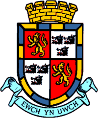
Subdivisions Type Hundreds, sanitary districts, urban districts, rural districts Radnorshire (Welsh: Sir Faesyfed) is one of thirteen historic and former administrative counties of Wales. It is represented by the Radnorshire area of Powys, which according to the 2001 census, had a population of 24,805.[2] The historic county is bounded to the north by Montgomeryshire and Shropshire, to the east by Herefordshire, to the south by Brecknockshire and to the west by Cardiganshire.
The county was formed from the cantrefs of Maelienydd and Elfael and the commotes of Gwrtheyrnion and Deuddwr (the area formerly known as Rhwng Gwy a Hafren) by the Laws in Wales Acts 1535-1542. New Radnor was considered the county town, although it historically shared administrative functions with Presteigne where the Assizes sat. Radnor County Council and later the District Council were based instead at Llandrindod Wells.
The county was abolished by the Local Government Act 1972 in 1974, with its area being transferred to the new county of Powys.[3][4] Powys was divided into three districts, one of which (Radnor) was coterminous with Radnorshire. The district was renamed Radnorshire in 1989. Since Powys became a unitary authority in 1996, Radnorshire has been one of three areas formed under a decentralisation scheme. A "shire committee" consisting of councillors elected for electoral divisions within the former district of Radnorshire exercises functions delegated by Powys County Council.[5]
Contents
Geography
In the east and south are some comparatively level tracts, including the Vale of Radnor, but most of the county was mountainous, with the Cambrian Mountains running through the west of the county. The highest point is at Radnor Forest, 2,166 ft (660 m). The Elan Valley contains several huge man-made reservoirs supplying water to Birmingham. The main rivers are the Wye, The River Teme, the Elan and the Ithon.
The chief towns are Knighton, Llandrindod Wells, Presteigne and Rhayader. The main industries are tourism and hill farming, particularly sheep-raising.
Subdivisions
Hundreds
On the creation of the county it was divided into six hundreds. The names of the hundreds, which were not always consistently spelt, were as follows:[6]
- Colwyn
- Cefnllys (Kevenlleece or Cevnllŷs)
- Knighton
- Painscastle
- Radnor
- Rhaiadr (or Rhayader)
Local government districts
Poor law unions
In the 19th century new structures of local administration were introduced. The Poor Law Amendment Act 1834 grouped parishes into poor law unions. While these were not themselves local authorities, their boundaries were to later be used to define local government districts. PLUs did not conform to county boundaries, but consisted of catchment areas for workhouses. Most of Radnorshire was included in the three unions of Knighton, Presteigne and Rhayader.[7] Parishes on the edges of the county were included in unions based in other counties: Builth and Hay on Wye in Brecknockshire and Kington in Herefordshire.
Local boards of health
There were no town councils in the county until 1850, when a local board was formed at Knighton.[8] Similar bodies were later formed at Llandrindod Wells (originally named Trefonen) and Presteigne in 1891.[9][10]
Sanitary districts
The Public Health Act 1875 divided England and Wales into sanitary districts, each governed by a sanitary authority. Instead of creating new bodies, existing local board districts became urban sanitary districts (USDs) and the remaining areas of poor law unions became rural sanitary districts (RSDs). The existing local board or poor law guardians became the sanitary authority for their area. By 1891 therefore, Radnorshire was divided between the following sanitary districts:
- Builth RSD (part)
- Hay RSD (part)
- Kington RSD (Part)
- Knighton RSD
- Knighton USD
- Llandrindod Wells USD
- Presteigne RSD (dissolved in 1877, with parishes redistributed to Kington and Knighton RSDs)[11]
- Presteigne USD
- Rhayader RSD
Urban and rural districts
 Urban and rural districts of Radnorshire 1894 - 1974:
a) Llandrindod Wells UD, b) Knighton UD, c) Presteigne UD, 1) Rhayader RD, 2) Knighton RD 3) New Radnor RD, 4) Colwyn RD, 5) Painscastle RDThe Local Government Act 1894 created urban districts (UDs) and rural districts (RDs) in place of the sanitary districts. Directly elected urban and rural district councils became the governing bodies. The new districts were identical to the sanitary districts, with the exception that where a RSD was divided by a county boundary it was split into separate rural district in each county. Radnorshire was divided into eight UDs and RDs, which were unchanged until their abolition in 1974:
- Colwyn RD (from Builth RSD)
- Knighton RD
- Knighton UD
- Llandrindod Wells UD
- New Radnor RD (from Kington RSD)
- Painscastle RD (from Hay RSD)
- Presteigne UD
- Rhayader RD
Coat of arms
Until 1954 Radnorshire County Council used a version of the arms of the Mortimers, Earls of March: Barry of six or and azure on a chief of the last two pallets azure between as may gyrons of the first.[12][13] The council received a grant of armorial bearings by the College of Arms in 1954.[14] The arms were made up of charges from local families. A gold reguardant lion on red was for Elystan Glodrhydd, Prince of Wales c.1000; black boars' heads on white for his son Cadwgan. Around these was placed a gold and blue compony bordure based on the Mortimer arms. The motto adopted by the county council was (Welsh: Ewch yn Uwch) (Go Higher). In 1974 the arms were transferred to Radnor District Council.[15] In 1996 the arms were transferred a second time to Powys County Council, for use by the Radnorshire Shire Committee.[16]
History and culture
The geographic territory of the historic county roughly corresponds with the Welsh territory of Rhwng Gwy a Hafren which fell under the control of the Marcher Lords at the end of the 11th Century. Radnorshire was a poor county and has been an historical backwater but occasionally has drifted to the forefront of history. The most notable historic events are the Battle of Bryn Glas fought on June 22, 1402 during the rebellion of Owain Glyndŵr, and the founding of Cwmhir Abbey.
The county's poverty was remarked upon thus in the 17th century by an anonymous visitor:
“ Poor Radnorsheer, poor Radnorsheer,
Never a park, and never a deer,
Never a squire of five hundred a year,
Save Richard Fowler of Abbey-Cwm-hir” Apart from a handful of parishes along the English border the Welsh language remained the first language of the county well into the second half of the eighteenth century.[17] By 1850 the language had retreated to the western parishes of Rhayader, Llanyre, Cwmdauddwr, St Harmon and Nantmel.[6] By 1900 Welsh was still spoken by a sizeable minority west of the town of Rhayader, the language disappearing as the century progressed. Of course there were Welsh speakers living in Radnorshire who had come from other parts of Wales and today their number has been swelled by children being educated through the medium of Welsh in school.
Until the Acts of Union, Radnor was outside the Principality of Wales. This peculiar Marcher status and its want of Welsh speakers gave weight to the traditional local expression, "Neither Wales nor England, just Radnorsheer"[18]
Places of special interest
 St Mary's Church, Pilleth
- Abbey Cwmhir aka Abbeycwmhir (SO0571);
- Beguildy Tumuli (SO176767);
- Broadheath House, Presteigne (SO3363);
- Elan Valley Visitor's Centre (SN927646);
- The Pales (SO138641);
- Offa's Dyke (SO2763, SO2872);
- The Rock Park, Llandrindod Wells (SO052609).
- Royal Welsh Showground, Llanelwedd
- Pilleth Church and the Battle of Bryn Glas
Principal towns and villages
No centre in Radnorshire exceeds a population of 6,000; only one (Llandrindod Wells) exceeds 5,000:
- Knighton
- Llandrindod Wells
- Presteigne
- Rhayader
- Newbridge on Wye
- New Radnor
Radnorshire Diaspora
Poverty and agricultural change, decline and industrial progress elsewhere has always made Radnorshire a place of net emigration. Emigrants employed the name of the county in the USA
- Radnor Lake State Park, Nashville, Tennessee
- Radnor Township, Delaware County, Pennsylvania. Part of the Welsh Tract first settled in 1663–1665 by a group of 40 Quakers from Radnorshire.[19]
- Radnor Township, Delaware County, Ohio
Others may have formed part of the Welsh community in Patagonia.[citation needed]
See also
- List of Lord Lieutenants of Radnorshire
- List of High Sheriffs of Radnorshire
- Radnorshire (UK Parliament constituency) - A list of MPs
- Red Kite feeding in Wales
References
- ^ Vision of Britain - 1831 Census
- ^ "Powys County Council - Census" (PDF). http://www.powys-i.org.uk/documents/en/powys_i_stats/Census%202001/Key%20Statistics/Shires/KS_R.pdf. Retrieved 18 December 2007.
- ^ Local Government Act 1972 c.70 s.20 and 216
- ^ "Local Government Reorganisation". Hansard 1803 - 2005. 1972-12-15. http://hansard.millbanksystems.com/written_answers/1972/dec/15/local-government-reorganisation. Retrieved 2008-07-26.
- ^ "Article 10 - Shire Committees" (PDF). Articles of the Constitution. Powys County Council. http://www.powys.gov.uk/uploads/media/Part_2_-_Article_10_bi_02.pdf. Retrieved 2008-07-26.
- ^ a b "Radnor - Radnorshire". A Topographical Dictionary of Wales. British history Online. 1849. http://www.british-history.ac.uk/report.aspx?compid=47881. Retrieved 2009-02-10.
- ^ "Poor Law: Board of Guardians". Archives Office. Powys County Council. http://www.powys.gov.uk/index.php?id=1733. Retrieved 2009-02-10.
- ^ "Knighton". Kelly's Directory of Monmouthshire and South Wales. Historical Directories. 1895. http://www.historicaldirectories.org/hd/makepdf.asp?fn=E:\ZYIMAGE\DATA\HISTDIR\TIF\LUL5002Atif\0000cxk0.tif. Retrieved 2009-02-10.
- ^ Census of England and Wales 1901, County Report, Radnorshire
- ^ "Presteigne". Kelly's Directory of Monmouthshire and South Wales. Historical Directories. 1895. http://www.historicaldirectories.org/hd/makepdf.asp?fn=E:\ZYIMAGE\DATA\HISTDIR\TIF\LUL5002Atif\0000CXRM.TIF. Retrieved 2009-02-10.
- ^ "Presteigne Registration District". GENUKI. UKBMD. http://www.ukbmd.org.uk/genuki/reg/districts/presteigne.html. Retrieved 2009-02-10.
- ^ A C Fox-Davies, The Book of Public Arms, 2nd edition, London 1915
- ^ Mary O'Regan, Heraldry of the Old Welsh Counties, Part 2, in Aspects of Heraldry, Vol.9, Yorkshire Heraldry Society, 1995
- ^ Geoffrey Briggs, Civic and Corporate Heraldry, London, 1971
- ^ "Radnorshire District Council". Civic Heraldry of England and Wales. http://www.civicheraldry.co.uk/wales_7496.html. Retrieved 2008-07-26.
- ^ "The Local Authorities (Armorial Bearings) (No. 2) (Wales) Order 1996 (S.I. 1996 No. 1930)". Office of Public Sector Information. 1996. http://www.opsi.gov.uk/si/si1996/Uksi_19961930_en_2.htm. Retrieved 2008-07-26.
- ^ F G Payne, Crwydro Sir Faesyfed Vol I (1966) & Vol II (1968), Llandybïe
- ^ "Judges Lodgings". http://www.judgeslodging.org.uk/Pages/history.php. Retrieved 2009-04-20.[dead link]
- ^ "Radnor Township". http://www.radnor.com/department/index.asp?fDD=19-0. Retrieved 18 December 2007.
Further reading
The leading texts on Radnorshire history are:
- Donald Gregory (1994). Radnorshire. ISBN 0863812848. (Amazon)
- Keith Parker (2000). Radnorshire from Civil War to Restoration. ISBN 1873827865. (Amazon)
- Peter J Conradi (2009). At the Bright Hem of God. ISBN 9781854114907.
External links
- "County: Radnorshire Wales". Vision of Britain. University of Portsmouth. http://www.visionofbritain.org.uk/place/place_page.jsp?p_id=17429&st=Radnorshire. Retrieved 2009-04-20.
- "Radnorshire". A Topographical Dictionary of Wales. British History Online. 1849. http://www.british-history.ac.uk/report.aspx?compid=47881#s4. Retrieved 2009-04-20.
- John Clark (1794). General view of the agriculture of the county of Radnor: with observations on the means of its improvement. Board of Agriculture. http://books.google.ie/books/download/General_view_of_the_agriculture_of_the_c.pdf?id=GkEIAAAAQAAJ&output=pdf&sig=ACfU3U0hVTX21gYzV8MzDjJljLZ7FB_Lzw. Retrieved 2009-04-20.
- "Radnorshire, Wales". The National Gazetteer of Great Britain and Ireland. GENUKI. 1868. http://www.genuki.org.uk/big/wal/RAD/Gaz1868.html. Retrieved 2009-04-20.
Anglesey • Brecknockshire • Caernarfonshire • Carmarthenshire • Cardiganshire • Denbighshire • Flintshire • Glamorganshire • Merionethshire • Monmouthshire • Montgomeryshire • Pembrokeshire • Radnorshire
Categories:


Wikimedia Foundation. 2010.