- Obuasi Municipal District
-
Obuasi Municipal District — District — Districts of Ashanti Districts of Ashanti
 Obuasi Municipal District
Coordinates: 6°12′N 1°41′W / 6.2°N 1.683°W Country  Ghana
GhanaRegion Ashanti Region Capital Obuasi Government – District Executive Joseph K. Boampong Time zone GMT (UTC+0) The Obuasi Municipality District is one of the 26 districts of Ghana located in the Ashanti Region which was created as part of the government’s effort to further decentralize governance. It was carved out of the erstwhile Adansi West District Assembly (AWDA) on the strength of executive instruments (E. I.) 15 of December, 2003 and Legislative Instrument L. I. 1795 of 17th March, 2007. The Municipality is located at the southern part of Ashanti Region between latitude 5.35N and 5.65N and longitude 6.35N and 6.90N. It covers a land area of 1624km2. There are 53 communities in the Municipality which share 30 electoral areas. It is bounded to the east by the Adansi South district, west by Amansie Central district, to the north by Adansi North district and to the south by the Upper Denkyira District. It has Obuasi as its Administrative Capital where the famous and rich Obuasi Gold Mine, now AngloGold Ashanti is located.
The Municipality has a rather undulating topography and the climate is of the semi-equatorial type with a double rainfall regime. Mean annual rainfall ranges between 1250mm and 1750mm. Mean average annual temperature is 25.5oC and relative humidity is 75% - 80% in the wet season.
The population of the Municipality is estimated at 205,000 using the 2000 Housing and Population Census as a base and applying a 4% annual growth rate. The vegetation is predominantly a degraded and semi-deciduous forest. The forest consists of limited species of hardwood which are harvested as lumber. The Municipality has nice scenery due to the hilly nature of the environment.
John Alexander Ackon is currently the MCE of Obuasi.
Sources
- Districts of Ghana at statoids.com
- GhanaDistricts.com
Coordinates: 6°12′N 1°41′W / 6.2°N 1.683°W
Districts of the Ashanti Region of Ghana 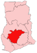 Adansi North · Adansi South · Afigya-Kwabre · Ahafo Ano North · Ahafo Ano South · Amansie Central · Amansie West · Asante Akim North Municipal · Asante Akim South · Atwima Kwanwoma · Atwima Mponua · Atwima Nwabiagya · Bekwai Municipal · Bosome Freho · Bosomtwe · Ejisu-Juaben Municipal · Ejura/Sekyedumase · Kumasi Metropolitan · Kwabre · Mampong Municipal · Obuasi Municipal · Offinso Municipal · Offinso North · Sekyere Afram Plains · Sekyere Central · Sekyere East · Sekyere South
 Categories:
- Ghana geography stubs
- Districts of Ashanti Region


Wikimedia Foundation. 2010.