- Cohoes Falls
-
Cohoes Falls 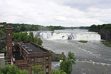
Falls seen from the southLocation Cohoes and Waterford, NY, USA Coordinates 42°47′16″N 73°42′30″W / 42.78778°N 73.70833°W Type Block Elevation 180 feet (55 m) Total height 90 feet (27 m) Total width 1,000 feet (300 m) Watercourse Mohawk River Average flow rate 90,000 cubic feet (2,500 m3) Cohoes Falls is a waterfall on the Mohawk River shared by the city of Cohoes and the town of Waterford, New York, United States. Discovered by the indigenous Mohawk tribe, the falls were originally called Ga-ha-oose, which is believed to mean "The Place of the Falling Canoe." Cohoes historian Arthur Masten wrote in his 1880 history that the phrase might mean "Potholes in the River," referring to the potholes that appear in the riverbed when it is dry. In the oral tradition of the Haudenosaunee (Iroquois), the Cohoes Falls are the site where The Great Peacemaker, also known as Deganawida, performed a feat of supernatural strength, convincing the Mohawk people to become the founders of the Iroquois League of Nations or Confederacy. Some historians believe the Mohawks launched the Confederacy as early as 1142 CE, though other experts report dates ranging from 1450-1650.
 Engraving of the Cohoes Falls in 1778, one of the earliest images of the falls.
Celebrated by 18th century travelers in letters and journals, the Cohoes Falls, also called The Great Falls of the Mohawk, were regarded as the second most beautiful cataract in New York State after Niagara. In 1804, the national poet of Ireland, Thomas Moore, visited Cohoes and wrote a paean to the waterfall's beauty: "Lines Written at the Cohos (sic), or Falls of the Mohawk River."
In 1831, town leaders built a dam across the Mohawk River to harness the power of the falls to fuel the turbines of the city's burgeoning textile industry. Over the next several decades, the predominant company, Harmony Mills, became the largest manufacturer of cotton in the United States, thanks to its control of local water rights. When all the mills closed in the wake of the Great Depression, city leaders neglected the potential of the falls for tourism. They leased the flow rights to a series of power companies, including Niagara Mohawk and Orion Power.
 Cohoes Falls in Winter - Very Low.
 Cohoes Falls in Spring - High Volume.
 Cohoes Falls in April - Dry.
The Erie Canal was planned to overcome the navigational barrier of the Cohoes Falls. The original "Clinton's Ditch", the Erie Canal of 1825, was built through the city of Cohoes. The later Enlarged Canal was realigned, yet still went through the City of Cohoes. The Barge Canal, which opened in 1918, bypasses Cohoes and runs though the Village of Waterford via the Waterford Flight of Locks.
The Cohoes Falls is 90 feet (28 m) high and 1,000 feet (305 m) wide. Its flow is most impressive in springtime, sometimes running at 90,000 cubic feet (2,500 m3) of water per second,[1] but as the season changes, there is less water for the falls because so much of the flow is diverted at the Crescent Dam to the Barge Canal through Lock 6. Most of the water is still diverted for power generation; some is diverted for the Cohoes water supply. During the summer, the falls are virtually dry, revealing shale rock formations that have their own distinctive beauty.
Comparing Cohoes Falls To Niagara Falls
Width of Cohoes Falls is roughly 1,000 feet (300 m). Niagara Falls width is 830 feet (250 m) for American Falls and 2,200 feet (670 m) for Horseshoe Falls.
Height of Cohoes Falls ranges from 75 feet (23 m) on the north side to 90 feet (27 m) on the south end. Niagara Falls height is 70 to 110 feet (34 m) for American Falls and 163 feet (50 m) for Horseshoe Falls.
Water flow over Cohoes Falls ranges from zero to 90,000 cubic feet per second. Water flow over Niagara Falls ranges from 5,000 to 21,000 cubic feet per second for American Falls and 45,000 to 190,000 cubic feet per second for Horseshoe Falls.References
- ^ "The Cohoes Falls". The City of Cohoes. http://www.cohoes.com/cit-e-access/webpage.cfm?TID=34&TPID=6432. Retrieved 2009-01-12.
External links
Coordinates: 42°47′16.68″N 73°42′30.72″W / 42.7879667°N 73.7085333°W
Categories:- Cohoes, New York
- Erie Canal
- Waterfalls of New York
- Geography of Saratoga County, New York
- Geography of Albany County, New York
- Visitor attractions in Albany County, New York
- Visitor attractions in Saratoga County, New York


Wikimedia Foundation. 2010.