- Mawkmai
-
Mawkmai — Town — Location in Burma
 Mawkmai
Coordinates: 20°14′N 97°44′E / 20.233°N 97.733°ECoordinates: 20°14′N 97°44′E / 20.233°N 97.733°E Country  Burma
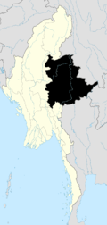
BurmaState Shan State District Loilen District Township Mawkmai Township Time zone MST (UTC+6.30) Mawkmai is a town and capital of Mawkmai Township in Loilen District, Shan State, Burma. Mawkmai is connected by road to Loimut in the west and Langkho in the northeast which connects with the National Road 45.[1][2]
References
- ^ Google Maps. Maps (Map).
- ^ Microsoft and Harris Corporation Earthstar Geographics LLC. Bing Maps (Map).
Capital: Mawkmai Ailōngwanham • Daw Dawhta • Daw Hki-yè • Daw Hsa-lè (19°51'11"N 97°36'9"E) • Daw Hsa-lè (19°50'57"N 97°33'42"E) • Daw Hsawhko • Daw Htè-ku • Daw Pè-lè • Daw Pi-tu • Daw Ta-hpwi • Daw Ta-lè • Dawta-pu-lya • Hatmehso • Hkengnang • Hona • Ho-na • Ho-nam • Ho-pom • Hpaknam • Hpaknamtan • Hpa-leng (20°27'0"N 97°32'0"E) • Hpa-leng (20°20'0"N 97°34'0"E) • Hpa-san • Hsaingon • Htiomcheng • Htolawng • Hweheng • Hwesang • Hwè-teng-yang • Kantu-awn • Kantu-long • Kawngmuput • Komka • Komkyat • Kongkeng • Kongleng • Konglong • Kongpekhso • Kongsa • Kongtong • Kongyai • Kūnghsāng • Kūnglom • Kunhkan • Kunpu-kè • Laipye • Lingpwa • Loihkok • Loi-hoi • Loihpwe • Loihsamhsip • Loi-hsau • Loihun • Loikawng (20°24'0"N 97°31'0"E) • Loikawng (20°16'0"N 97°31'0"E) • Loikyu • Loimun (20°28'0"N 97°30'0"E) • Loimun (20°27'0"N 97°29'0"E) • Loisoi • Longmakpai • Lünghsa-ye • Mai-hka-long • Mai-hsa-se • Maklam • Maklang • Makmong (20°24'0"N 97°42'0"E) • Makmong (20°15'0"N 97°43'0"E) • Makmonglau • Mawkmai • Melawn • Na-awn • Nā-hka • Na-hka-awn • Na-hkem • Nahkemhkum • Nā-hsai • Namawn • Namkat • Namlawt • Namlin (20°22'0"N 97°36'0"E) • Namlin (20°19'0"N 97°39'0"E) • Nammawhpek • Nammawhsōm • Nammawlong • Nammawwan • Namme-hik • Namnoi • Nampa-pong • Nampen • Nam-yan • Nawng-e • Nawnghang • Nawngheng • Nawnghi • Nawnghkam • Nawngkawnggyi • Nawngmo • Nawngpe • Nawngpong • Nawngpyi • Nawngtonhong • Nawngywe • Nayawng • Ngo-yeng • Pangkeng • Pāngkwe • Pānglaw • Pangmawn • Pangngang • Pāngngawk • Pāngpek • Pangtan • Pāngtang (20°24'0"N 97°50'0"E) • Pāngtang (20°24'0"N 97°33'0"E) • Pāngtawng • Pawmong • Pekheng • Ponglau • Pu-ya-sang • Saihok • Sa-lawng • Sa-ti-long • Shwe-lambo-yat • Tahpunto • Tapuhto • Tawngkeng • Ti-hunhkwe • Ti-wa-mü-pe • Tonmai-hong • Tunkeng • Wān Hang-hi • Wān Hka-lau • Wān Hkōng • Wān Ho-nawng • Wān Ho-pong • Wān Hpā-hin • Wān Hpai-mai • Wān Hpa-lawm • Wān Hwè-hāng • Wān Hwè-hka • Wān Hwè-hok • Wān Kāng (20°18'0"N 97°33'0"E) • Wān Kang (20°12'0"N 97°44'0"E) • Wān Kanna • Wān Kè-hkūn • Wān Kong • Wān Kongpao • Wān Konnā • Wānkun • Wān Kūngpao • Wān Kyawng (20°19'0"N 97°42'0"E) • Wān Kyawng (20°17'0"N 97°43'0"E) • Wān Kyu • Wān Langhak • Wān Linmon • Wān Loi-lim (20°14'0"N 97°42'0"E) • Wān Loi-lim (20°6'0"N 97°41'0"E) • Wān Loi-mon • Wān Long • Wān Lūktan • Wān Māk (20°20'0"N 97°35'0"E) • Wān Māk (19°59'7"N 97°26'0"E) • Wān Mākkēnglong • Wān Māk-nö • Wān Ma-kon • Wān Mè-sa-lawm • Wān Mong • Wān Na-hi • Wān Na-hka • Wān Nammawwān • Wān Nawnghkam • Wān Nawngkao • Wān Nawnglawng • Wān Nawngleng • Wān Nö • Wān Pākkao • Wān Pānghkang • Wān Pānglaw • Wān Pānglong • Wān Pānglu • Wān Pāngman • Wān Pangmawng • Wān Pāngwo • Wān Pa-pu • Wān Ponglao • Wān Pu-luk • Wān Pūngsawk • Wān Pu-sang • Wān Tawn • Wān Ungkop • Wān Yang • Wān YangShan State Capital: Taunggyi Taunggyi District 
Loilem District Loilem Township · Nansang Township · Kunhing Township · Lai-Hka Township · Kyethi Township · Mong Kung Township · Mong Hsu TownshipLashio District Mu Se District Kyaukme District Kunlong District Kengtung District Mong Hsat District Tachileik District Mong Hpayak District Langkho District Danu Self-Administered Zone Pa-O Self-Administered Zone Pa Laung Self-Administered Zone Kokang Self-Administered Zone Konkyan Township · Laukkaing TownshipWa Self-Administered Division Hopang Township · Mongmaw Township · Panwai Township · Nahpan Township · Metman Township · Pangsang TownshipMain cities and towns Taunggyi · Ayetharyar · Nyaungshwe · Hopong · Hsi Hseng · Kalaw · Aungban · · Lawksawk · Pinlaung · Pekon · Loilen · Pang Long · Langkho · Nansang · Kunhing · Mong Nai · Lai-Hka · Mawkmai · Mong Pan · Hong Pai · Kyethi · Mong Kung · Mong Hsu · Mong Ton · Lashio · Hseni · Mongyai · Tangyan · Muse · Mongko · Nanhkan · Kutkai · Kyaukme · Nawnghkio · Hsipaw · Namtu · Namhsan · Mongmit · Mabein · Mantong · Kunlong · Hopang · Laukkaing · Chinshwehaw · Kengtung · Mong Khet · Mong Yang · Mong Hsat · Mong Ping · Tachileik · Mong Hpayak · Mong YawngCategories:- Township capitals of Burma
- Mawkmai Township
- Shan State geography stubs


Wikimedia Foundation. 2010.