- Massachusetts Route 213
-
Route 213
Loop Connector
Albert Slack Memorial Highway
Route information Length: 3.5557 mi[2] (5.7223 km) Existed: 1964[1] – present Major junctions West end:  Interstate 93 in Methuen
 Route 28 in Methuen
 Route 113 in Methuen
East end:  Interstate 495 in Methuen
Highway system Massachusetts State Highway Routes
←  Route 203
Route 220  →
→Route 213 is a short 3½ mile state highway in Massachusetts. It connects Interstate 93 with Interstate 495 in Methuen, Massachusetts, just south of the New Hampshire border. It is a four-lane, controlled access highway along its entire length. Route 213 is also known locally as The Loop, due to its semicircular routing between I-93 and I-495. Route 213 is famous for allowing a traveler to cross the entire breadth of the city of Methuen in 120 seconds. The highway is a northern bypass of Route 113, which serves the downtown area, and derives its own number from it.
Signs for Route 213 on both I-93 and I-495 designate Route 213 as "LOOP CONNECTOR" (in all caps). The LOOP CONNECTOR signs were added when The Wilder Companies redeveloped the former Methuen Mall into a new shopping center known as The Loop.
According to MassDOT, Route 213 carries approximately 45,000 vehicles per day.[3]
Contents
Route description
Route 213 begins in the west as an offshoot of I-93 at its northernmost exit in Massachusetts, Exit 48. It begins by traveling to the east for less than a half mile before meeting Route 28 (Broadway) at Exit 2.
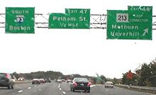 Guide sign assembly on southbound I-93, referring to Route 213 as "Loop Connector" (shown as "LOOP CONNECTOR").
Route 28 southbound provides access to the downtown area which Route 213 bypasses (it is a northern bypass of Route 113, which cuts west-to-east through the city). Route 28 northbound parallels I-93, crossing into Salem, New Hampshire and becoming New Hampshire Route 28 after approximately one-half mile.
Route 213 contiunues eastward for about another mile before interchanging with Route 113 (Pleasant Street), with access between Route 113 and westbound Route 213 facilitated by nearby Howe Street. Another half mile or so to the east, Route 213 interchanges with Route 113 again, via a short connecting road to Exit 4. This exit provides nearby access to "The Loop." Route 213 continues a short distance to the east, crossing underneath Route 113 before ending at an interchange with I-495.
History
The road was initially planned to start in Lowell at US-3 at a point between exits 31 and 32. From there, it was to have run north, crossing the Merrimack River roughly at the site of the current Rourke Bridge. It would then continue north through a portion of the Lowell-Dracut State Forest before turning east through until crossing I-93 in Methuen and ending at I-495. However, environmental regulations, a growing opposition in both Lowell and Dracut, and a projected insufficient demand for the road caused the state to permanently kill the portion of the highway between US-3 and I-93.
The expressway (which at this time was known as "Relocated Route 113") between I-93 and the current Exit 3 interchange was completed on September 11, 1962, when it was ceremonially named the Albert Slack Memorial Highway. The eastward extension to I-495 was completed in 1964, and Massachusetts Department of Public Works officially designated the road as Route 213. State officials unsuccessfully submitted for inclusion of Route 213 in the Interstate Highway System in 1970, in an attempt to gain federal funding for the project. The submission was rejected by the Federal Highway Administration.[3]
Route 213 was officially designated as the Loop Connector in October 2000 by the Massachusetts legislature.[3]
Exit list
Exits are numbered from west to east.
County Location Exit[4] Mile[5] Intersecting roads Notes Essex Methuen 1A-B 0.02 Interstate 93Western terminus of Route 213; I-93 Exit 48.
Westbound exit/eastbound entrance.2 0.82 Route 28To  NH Route 28, via Route 28 North.
3 2.15 Route 113 (Pleasant Street)Access between Route 213 West and Route 113 via Howe Street. 4 2.82 Route 113 (Pleasant Valley Street)To "The Loop" mall. 5A-B 3.56 I-495Eastern terminus of Route 213; I-495 Exit 47.
Eastbound exit/westbound entrance.References
- ^ The Roads of Massachusetts
- ^ Executive Office of Transportation, Office of Transportation Planning - 2005 Road Inventory
- ^ a b c Loop Connector (MA 213)
- ^ "Street Atlas of Metro Boston and Eastern Massachusetts." Bridgewater, Massachusetts: Arrow Map, Inc., 2003 Edition.
- ^ Massachusetts Executive Office of Transportation. 2007. "Interchange Exits List (MA 213). Downloaded from: http://www.eot.state.ma.us/default.asp?pgid=planning/disc/interchanges&sid=dtable August 7, 2011.
Categories:- Numbered routes in Massachusetts
- Methuen, Massachusetts
- Freeways in the United States


Wikimedia Foundation. 2010.