- Copernicus (lunar crater)
-
Copernicus (lunar crater) 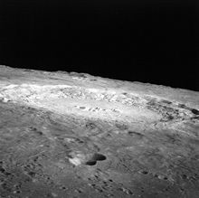
Lunar ray crater Copernicus from Apollo 12. NASA photo.Coordinates 9°42′N 20°00′W / 9.7°N 20.0°WCoordinates: 9°42′N 20°00′W / 9.7°N 20.0°W Diameter 93 km Depth 3.8 km Colongitude 20° at sunrise Eponym Nicolaus Copernicus Copernicus is a prominent lunar impact crater named after the astronomer Nicolaus Copernicus, located in eastern Oceanus Procellarum. It is estimated to be about 800 million years old, and typifies craters that formed during the Copernican period in that it has a prominent ray system.
Contents
Characteristics
Copernicus is visible using binoculars, and is located slightly northwest of the center of the Moon's Earth-facing hemisphere. South of the crater is the Mare Insularum, and to the south-south west is the crater Reinhold. North of Copernicus are the Montes Carpatus, which lie at the south edge of Mare Imbrium. West of Copernicus is a group of dispersed lunar hills. Due to its relative youth, the crater has remained in a relatively pristine shape since it formed.
The circular rim has a discernible hexagonal form, with a terraced inner wall and a 30 km wide, sloping rampart that descends nearly a kilometer to the surrounding mare. There are three distinct terraces visible, and arc-shaped landslides due to slumping of the inner wall as the crater debris subsided.
Most likely due to its recent formation, the crater floor has not been flooded by lava. The terrain along the bottom is hilly in the southern half while the north is relatively smooth. The central peaks consist of three isolated mountainous rises climbing as high as 1.2 km above the floor. These peaks are separated from each other by valleys, and they form a rough line along an east-west axis. Infrared observations of these peaks during the 1980s determined that they were primarily composed of the mafic form of olivine.
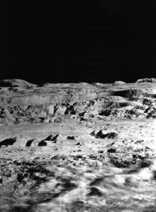 "Picture of the Century" – oblique view of the interior of Copernicus from Lunar Orbiter 2. NASA photo.
Based on high-resolution images from Lunar Orbiter 5, Terry W. Offield of the U.S. Geological Survey described the crater as having,
“ ...a hummocky crater rim, numerous large slump blocks on the crater wall, and a complex of central peaks. Sets of parallel fractures, aligned with the lunar structure grid, formed after the crater wall took its present form, but before the smoothest floor materials were emplaced. The smooth floor materials show a swirling pattern of cracks like those seen on terrestrial lava flows. These materials are associated with numerous hills that have summit craters and are probably small volcanoes. Several low places on the rim and wall are partly filled by what appears to be ponded volcanic material, or possibly fluidized impact debris. ” The crater rays spread as far as 800 kilometers across the surrounding mare, overlying rays from the craters Aristarchus and Kepler. The rays are less distinct than the long, linear rays extending from Tycho, instead forming a nebulous pattern with plumy markings. In multiple locations the rays lie at glancing angles, instead of forming a true radial dispersal. An extensive pattern of smaller secondary craters can also be observed surrounding Copernicus, a detail that was depicted in a map by Giovanni Cassini in 1680. Some of these secondary craters form sinuous chains in the ejecta.
Copernicus was given its name by Giovanni Riccioli, an Italian Jesuit who in conformity with church doctrine publicly opposed the heliocentric system revived by Nicolaus Copernicus. Riccioli is quoted as having "flung Copernicus into the Ocean of Storms" (Oceanus Procellarum); nevertheless in naming one of the most prominent craters on the Moon for the man, he may have indicated his true intent. Later the crater was nicknamed "the Monarch(ruler)of the Moon" by Thomas Gwyn Elger.
In 1966 the crater was photographed from an oblique angle by Lunar Orbiter 2 as one of 12 "housekeeping" pictures that were taken to advance the roll of film between possible astronaut landing sites being surveyed. At the time this detailed image of the lunar surface was termed by NASA Scientist Martin Swetnick and subsequently quoted by Time magazine as "one of the great pictures of the century."[1]
The Apollo 12 mission landed north of Copernicus on mare basalts of Oceanus Procellarum that were believed to have been in the path of one of the crater's rays, and scientists hoped cosmic ray exposure ages of soil samples would help constrain the crater age. The results were inconclusive, but not inconsistent with the estimated 800 million year age of crater formation. Copernicus itself was a possible landing site for the canceled Apollo 20 mission.
Satellite craters
By convention these features are identified on lunar maps by placing the letter on the side of the crater mid-point that is closest to Copernicus.
Copernicus Latitude Longitude Diameter A 9.5° N 18.9° W 3 km B 7.5° N 22.4° W 7 km C 7.1° N 15.4° W 6 km D 12.2° N 24.7° W 5 km E 6.4° N 22.7° W 4 km F 5.9° N 22.2° W 4 km G 5.9° N 21.5° W 4 km H 6.9° N 18.3° W 5 km J 10.1° N 23.9° W 6 km L 13.5° N 17.0° W 4 km N 6.9° N 23.3° W 7 km P 10.1° N 16.0° W 5 km R 8.1° N 16.8° W 3 km See also
References
- ^ "Space: A New Look at Copernicus". Time. 1966-12-09. http://www.time.com/time/magazine/article/0,9171,898477,00.html. Retrieved 2010-04-30.
- Pieters, C. M. (1982-01-01). "Copernicus crater central peak - Lunar mountain of unique composition". Science 215 (4528): 59–61. Bibcode 1982Sci...215...59P. doi:10.1126/science.215.4528.59. PMID 17790469.
- Cortright, Edgar M. (1968). "A Closer Look at Copernicus". SP-168 Exploring Space with a Camera. NASA Langley Research Center. pp. 116. http://history.nasa.gov/SP-168/section2b.htm#116.
- Wood, Chuck (2006-10-14). "Superb Copernicus". Lunar Photo of the Day. http://www.lpod.org/?m=20061014. Retrieved 2006-10-16.
- Andersson, L. E.; Whitaker, E. A., (1982). NASA Catalogue of Lunar Nomenclature. NASA RP-1097.
- Blue, Jennifer (July 25, 2007). "Gazetteer of Planetary Nomenclature". USGS. http://planetarynames.wr.usgs.gov/. Retrieved 2007-08-05.
- Bussey, B.; Spudis, P. (2004). The Clementine Atlas of the Moon. New York: Cambridge University Press. ISBN 0-521-81528-2.
- Cocks, Elijah E.; Cocks, Josiah C. (1995). Who's Who on the Moon: A Biographical Dictionary of Lunar Nomenclature. Tudor Publishers. ISBN 0-936389-27-3.
- McDowell, Jonathan (July 15, 2007). "Lunar Nomenclature". Jonathan's Space Report. http://host.planet4589.org/astro/lunar/. Retrieved 2007-10-24.
- Menzel, D. H.; Minnaert, M.; Levin, B.; Dollfus, A.; Bell, B. (1971). "Report on Lunar Nomenclature by the Working Group of Commission 17 of the IAU". Space Science Reviews 12 (2): 136–186. Bibcode 1971SSRv...12..136M. doi:10.1007/BF00171763.
- Moore, Patrick (2001). On the Moon. Sterling Publishing Co. ISBN 0-304-35469-4.
- Price, Fred W. (1988). The Moon Observer's Handbook. Cambridge University Press. ISBN 0-521-33500-0.
- Rükl, Antonín (1990). Atlas of the Moon. Kalmbach Books. ISBN 0-913135-17-8.
- Webb, Rev. T. W. (1962). Celestial Objects for Common Telescopes (6th revision ed.). Dover. ISBN 0-486-20917-2.
- Whitaker, Ewen A. (1999). Mapping and Naming the Moon. Cambridge University Press. ISBN 0-521-62248-4.
- Wlasuk, Peter T. (2000). Observing the Moon. Springer. ISBN 1-85233-193-3.
- Bugiolacchi et al., (2011) An in-depth look at the lunar crater Copernicus: Exposed mineralogy by high-resolution near-infrared spectroscopy
External links
Categories:- LQ11 quadrangle
- Impact craters on the Moon


Wikimedia Foundation. 2010.