- Western Australia
-
Coordinates: 26°0′S 121°0′E / 26°S 121°E
Western Australia 
Flag Coat of arms Slogan or nickname: Wildflower State or the Golden State 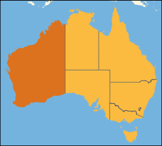
Other Australian states and territoriesCapital Perth Demonym Western Australian, West Australian, Sandgroper (colloquial) Government Constitutional monarchy - Governor Malcolm McCusker - Premier Colin Barnett (LP) Australian State - Established as Swan River Colony 1829 - Responsible Government as Western Australia 1890 - Became State 1901 - Australia Act 3 March 1986 Area - Total 2,645,615 km2 (1st)
1,021,478 sq mi- Land 2,529,875 km2
976,790 sq mi- Water 115,740 km2 (4.37%)
44,687 sq miPopulation (June 2010) - Population 2,296,411 (4thUNIQ7cd54b0d26cc27e7-nowiki-00000001-QINU1UNIQ7cd54b0d26cc27e7-nowiki-00000002-QINU) - Density 0.91/km2 (7th)
2.4 /sq miElevation - Highest Mount Meharry
1,249 m AHD (4,098 ft)Gross State Product (2009–10) - Product ($m) $187,834[2] (4th) - Product per capita $81,795 (1st) Time zone AWST (UTC+8) does not observe DST Federal representation - House seats 15 - Senate seats 12 Abbreviations - Postal WA - ISO 3166-2 AU-WA Emblems - Floral Red and Green Kangaroo Paw
(Anigozanthos manglesii)[3]- Animal Numbat
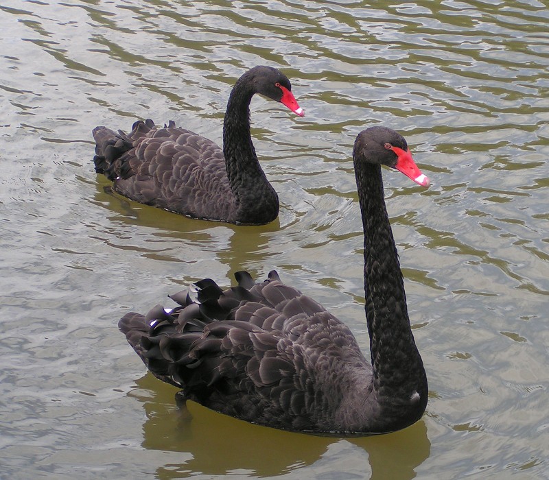
(Myrmecobius fasciatus)- Bird Black Swan
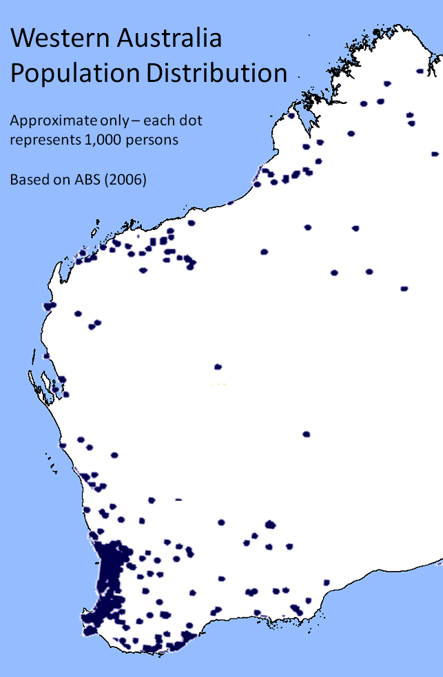
(Cygnus atratus)- Fossil Gogo Fish - Colours Gold and Black (from the State Badge) Web site www.wa.gov.au Western Australia (abbreviated as WA[4]) is a state of Australia, occupying the entire western third of the Australian continent. It is bounded by the Indian Ocean to the north and west, the Great Australian Bight and Indian Ocean to the south,[5] the Northern Territory to the north-east and South Australia to the south-east. Western Australia is Australia's largest state and the second largest subnational entity in the world. It has 2.3 million inhabitants (10% of the national total), 85% of whom live in the south-west corner of the state.
The first European to visit Western Australia was the Dutch explorer Dirk Hartog, who visited the Western Australian coast in 1616. The British established a military outpost at King George Sound, near present-day Albany, in 1826, which was followed by the establishment of the Swan River Colony in 1829, including the townsite of the present-day capital, Perth.
Western Australia achieved self-government in 1890, and later federated with the other British colonies in Australia in 1901. Today Western Australia's economy mainly relies on mining, agriculture and tourism. WA supplies 36% of Australia's overseas exports[6] and is the third largest iron-ore producer in the world.
Contents
Geography
Main article: Geography of Western AustraliaWestern Australia is bounded by South Australia and the Northern Territory to the east, and the Indian Ocean to the west and north. The International Hydrographic Organization (IHO) designates the body of water south of the continent as part of the Indian Ocean, although it is officially gazetted as the Southern Ocean in Australia.[5]
The total distance of the state's eastern borders is 1,862 km (1,157 mi),[7] and there is 12,889 km (8,009 mi) of coastline.[8] The total land area occupied by the state is 2.5 million km2.[9]
Natural history
Geology
The bulk of Western Australia consists of the extremely old Yilgarn craton and Pilbara craton which merged with the Deccan Plateau of India, Madagascar and the Karoo and Zimbabwe cratons of Southern Africa, in the Archean Eon to form Ur, one of the oldest supercontinents on Earth (3 – 3.2 billion years ago).
Because the only mountain-building since then has been of the Stirling Range with the rifting from Antarctica, the land is extremely eroded and ancient, with no part of the state above 1,245 metres (4,085 ft) AHD (at Mount Meharry in the Hamersley Range of the Pilbara region). Most parts of the state form a low plateau with an average elevation of about 400 metres (1,200 ft), very low relief, and no surface runoff. This descends relatively sharply to the coastal plains, in some cases forming a sharp escarpment (as with the Darling Range/Darling Scarp near Perth).
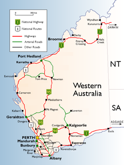 Western Australian cities, towns, settlements and road network.
The extreme age of the landscape has meant that the soils are remarkably infertile and frequently laterised. Even soils derived from granitic bedrock contain an order of magnitude less available phosphorus and only half as much nitrogen as soils in comparable climates in other continents. Soils derived from extensive sandplains or ironstone are even less fertile, being even more devoid of soluble phosphate and also deficient in zinc, copper, molybdenum and sometimes potassium and calcium.
The infertility of most of the soils has required heavy inputs of chemical fertilisers, particularly superphosphate, insecticides and herbicides, which—with the ensuing damage to invertebrate and bacterial populations, and compaction of soils through heavy machinery and hoofed mammals—has done great damage to the fragile soils.
Large-scale land clearing for agriculture has damaged habitats for native flora and fauna. As a result, the South West region of the state has a higher concentration of rare, threatened or endangered flora and fauna than many areas of Australia, making it one of the world's biodiversity "hot spots". Large areas of the state's wheatbelt region have problems with dryland salinity and the loss of fresh water.
Climate
The southwest coastal area has a Mediterranean climate and was originally heavily forested, including large stands of the karri, one of the tallest trees in the world.[10] This agricultural region of Western Australia is in the top nine terrestrial habitats for terrestrial biodiversity, with a higher proportion of endemic species than most other equivalent regions. Thanks to the offshore Leeuwin Current the area numbers in the top six regions for marine biodiversity, containing the most southerly coral reefs in the world.
Average annual rainfall varies from 300 millimetres (12 in) at the edge of the Wheatbelt region to 1,400 millimetres (55 in) in the wettest areas near Northcliffe, but in the months of November to March evaporation exceeds rainfall, and it is generally very dry. Plants must be adapted to this as well as the extreme poverty of all soils. A major reduction in winter rainfall has been observed since the mid-1970s, with a greater number of extreme rainfall events in the summer months.[11]
The central four-fifths of the state is semiarid or desert and is lightly inhabited with the only significant activity being mining. Annual rainfall averages 200–250 millimetres (8–10 in), most of which occurs in sporadic torrential falls related to cyclone events in summer months.
An exception to this is the northern tropical regions. The Kimberley has an extremely hot monsoonal climate with average annual rainfall ranging from 500 to 1,500 millimetres (20–60 in), but there is a very long almost rainless season from April to November. Eighty-five percent of the state's runoff occurs in the Kimberley, but because it occurs in violent floods and because of the insurmountable poverty of the generally shallow soils, the only development has taken place along the Ord River.
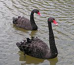 The Black Swan is the state bird of Western Australia
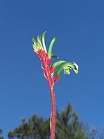 The Red and Green Kangaroo Paw is the floral emblem of Western Australia
Occurrence of snow in the state is rare, and typically only in the Stirling Range near Albany, as it is the only mountain range far enough south and with sufficient elevation. More rarely, snow can fall on the nearby Porongurup Range. Snow outside these areas is a major event; it usually occurs in hilly areas of southwestern Australia. The most widespread low-level snow occurred on 26 June 1956 when snow was reported in the Perth Hills, as far north as Wongan Hills and as far east as Salmon Gums. However, even in the Stirling Range, snowfalls rarely exceed 5 cm (2 in) and rarely settle for more than one day.[12]
The highest observed maximum temperature of 50.5 °C (122.9 °F) was recorded at Mardie, Pilbara, 61.6 kilometres (38.3 mi) from Barrow Island on 19 February 1998. The lowest minimum temperature recorded was −7.2 °C (19.0 °F) at Eyre Bird Observatory on 17 August 2008.[13]
Flora and fauna
Western Australia is home to around 540 species of birds (depending on the taxonomy used). Of these around 15 are endemic to the state. The best areas for birds are the southwestern corner of the state and the area around Broome and the Kimberley.
The Flora of Western Australia comprises 9437 published native vascular plant species of 1543 genera within 226 families, there are also 1171 naturalised alien or invasive plant species more commonly known as weeds.[14] In the southwest region are some of the largest numbers of plant species for its area in the world.
Specific ecoregions of Western Australia include: the sandstone gorges of The Kimberley on the northern coast and below that areas of dry grassland (Ord Victoria Plain) or semi-desert (Western Australian Mulga shrublands), with Tanami Desert inland from there. Following the coast south there is the Southwest Australia savanna and the Swan Coastal Plain around Perth, and then farther south the Warren on the southwest corner of the coast around the wine-growing area of Margaret River.
Going east along the Southern Ocean coast is the Goldfields-Esperance, Western Australia region including the Esperance grasslands and the Coolgardie grasslands inland around town of Coolgardie.
History
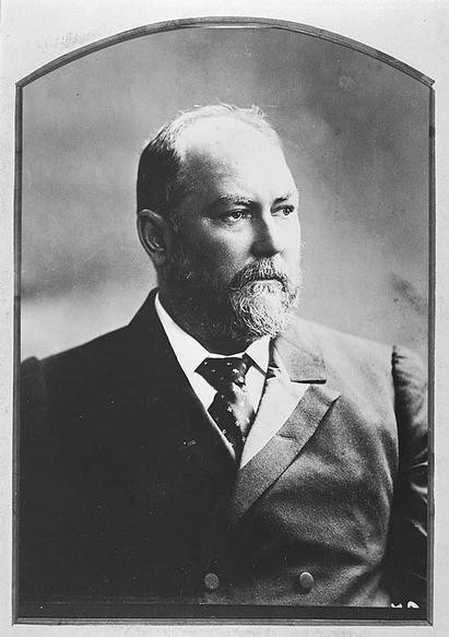
Main article: History of Western Australia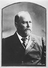 John Forrest was the first Premier of Western Australia.
The first inhabitants of Australia arrived from the north approximately 40,000 to 60,000 years ago. Over thousands of years they eventually spread across the whole landmass. These Indigenous Australians were well established throughout Western Australia by the time of European explorers began to arrive in the early seventeenth century.
The first European to visit Western Australia was a Dutch explorer, Dirk Hartog who on the 25th October 1616 landed at what is now known as Cape Inscription, Dirk Hartog Island. For the rest of the 17th century, other Dutch (and other nationalities) travellers encountered the coast, usually unintentionally, as many shipwrecks along the coast of ships that deviated (because of poor navigation and storms) from the Brouwer Route illustrate.[citation needed]. It was a further 200 years before it was proven that the Great Southern continent actually existed. By the late 18th century, British and French sailors had begun to explore the Western Australian coast.
The origins of the present state began with the establishment of a British settlement at King George Sound in 1826 (later named Albany from 1832). The settlement was founded in response to British concerns about the possibility of a French colony being established on the coast of Western Australia.
In 1829, the Swan River Colony was established on the Swan River by Captain James Stirling. By 1832, the British settler population of the colony had reached around 1,500, and the official name of the colony was changed to Western Australia. The two separate townsites of the colony developed slowly into the port city of Fremantle and the state's capital, Perth.
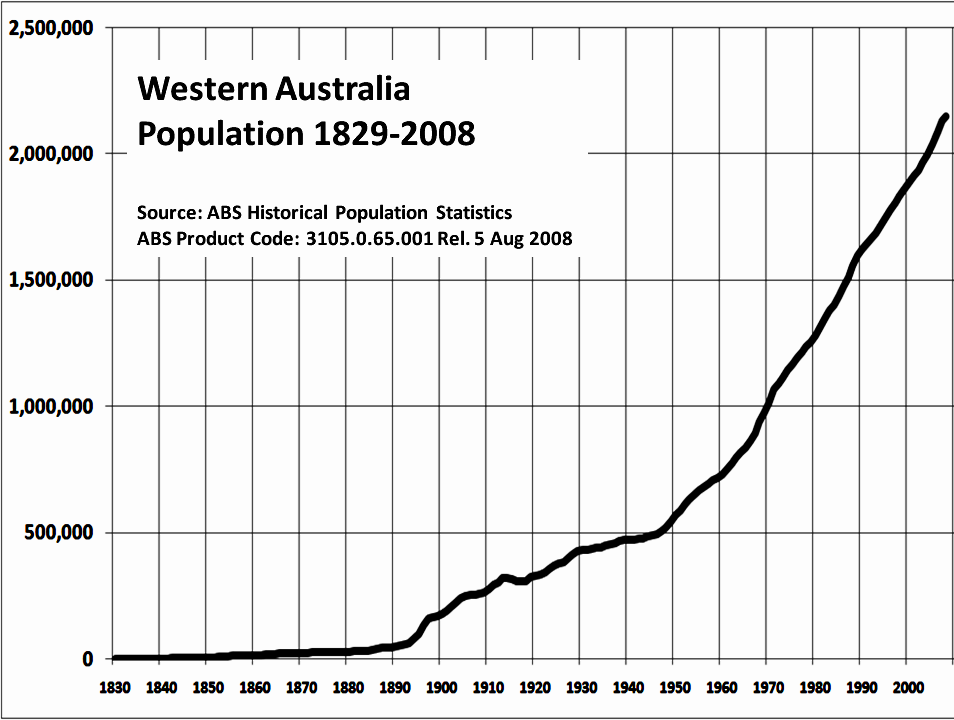
Population growth was very slow until significant discoveries of gold were made in the 1890s around Kalgoorlie.
In 1887, a new constitution was drafted, providing for the right of self-governance and in 1890, the act granting self-government to the colony was passed by the British House of Commons. John Forrest became the first Premier of Western Australia.
In 1896, the Western Australian Parliament authorised the raising of a loan to construct a pipeline to transport five million gallons of water per day to the Goldfields of Western Australia. The pipeline, known as the Goldfields Water Supply Scheme, was completed in 1903. C.Y. O'Connor, Western Australia's first engineer-in-chief, designed and oversaw the construction of the pipeline. It carries water 530 km (330 mi) from Perth to Kalgoorlie, and is attributed by historians as an important factor driving the state's population and economic growth.[15]
Following a campaign led by Forrest, residents of the colony of Western Australia (still informally called the Swan River Colony) voted in favour of federation, resulting in Western Australia officially becoming a state on 1 January 1901.
Demographics
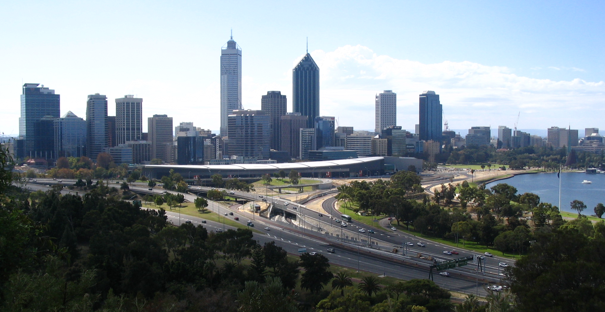
See also: Demographics of Australia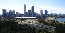 Western Australia's capital and largest city, Perth, from Kings Park. Its metropolitan area is home to 75% of the state's population.
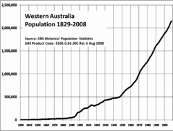
 Distribution of the Western Australian population.
Europeans began to settle permanently in 1826 when Albany was claimed by Britain to forestall French claims to the western third of the continent. Perth was founded as the Swan River Colony in 1829 by British and Irish settlers, though the outpost languished, eventually requesting convict labour to augment its population. In the 1890s, interstate migration resulting from a mining boom in the Goldfields region resulted in a sharp population increase.
Western Australia did not receive significant flows of migrants from Britain, Ireland or elsewhere in the British Empire until the early 20th century when local projects—such as the Group Settlement Scheme of the 1920s which encouraged farmers to settle the southwest—increased awareness of Australia's western third as a destination for colonists.
Led by migrants from the British Isles, Western Australia's population developed at a faster rate during the twentieth century than it had previously. Along with the eastern states, Western Australia received large numbers of Italians, Croatians and Greeks after World War II. Despite this, Britain has contributed the greatest number of migrants to this day, and Western Australia—particularly Perth—has the highest proportion of British-born of any state: 10.6% in 2006, compared to a national average of 5.3%. This group is heavily concentrated in certain parts where they account for a quarter of the population.
In terms of ethnicity, the 2001 census data reveals that 77.5% of Western Australia's population is of European descent: the largest single group was those reporting English ethnicity, accounting for 733,783 responses (32.7%), followed by Australian with 624,259 (27.8%), Irish with 171,667 (7.6%), Italian with 96,721 (4.3%), Scottish with 62,781 (2.8%), German with 51,672 (2.3%) and Chinese with 48,894 responses (2.2%). There were 58,496 Indigenous Australians in Western Australia in 2001, forming 3.1% of the population.
In terms of birthplace, according to the 2006 census[16] 27.1% of the population were born overseas—higher than the Australian average of 22.2%. 8.9% of West Australians were born in England, 2.4% in New Zealand, 1.2% in Scotland, 1.1% in South Africa, and 1.1% in Italy.
Perth's metropolitan area had an estimated population of 1.55 million in 2007 (75% of the state). Other significant population centres include Mandurah (78,612), Bunbury (32,499), Geraldton (31,553), Kalgoorlie (28,242), Albany (25,196), Broome (14,436), and Port Hedland (14,000).[17]
Economy
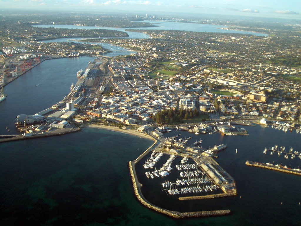
See also: Economy of Western Australia and Australian economy Aerial view of Fremantle Harbour, a major port in WA.
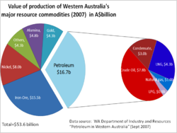 Western Australia's resource commodity mix, 2007.
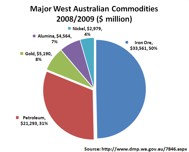
 Major commodity mix, 2008–2009.
Western Australia's economy is largely driven by extraction and processing of a diverse range of mineral and petroleum commodities. The structure of the economy is closely linked to the abundance of natural resources found in the State, providing a comparative advantage in resource extraction and processing. As a consequence:
- Western Australia contributes an estimated 58% of Australia's Mineral and Energy Exports.[18] Potentially earning up to 4.64% of Australia's total GDP.[19]
- Gross state product per person ($70,009) is higher than any other state and well above the national average ($54,606).[20]
- Diversification (i.e. a greater range of commodities) over the past 15 years has provided a more balanced production base and less reliance on just a few major export markets, insulating the economy from fluctuations in world prices to some extent.[citation needed]
- There has been strong growth in the services (finance, insurance and property) and construction sector, which have increased their share of economic output.[21][broken citation]
- Recent growth in global demand for minerals and petroleum, especially in China (iron-ore) and Japan (for LNG), has ensured economic growth above the national average.
Western Australia's overseas exports accounted for 36% of the nation's total.[22] The state's major export commodities include iron-ore, alumina, nickel, gold, ammonia, wheat, wool, live sheep and cattle, and crude oil and liquefied natural gas (LNG).
Western Australia is a major extractor of bauxite, which is also processed into alumina at four refineries providing more than 20% of total world production. It is the world's third-largest iron-ore producer (15% of the world's total) and extracts 75% of Australia's 240 tonnes of gold. Diamonds are extracted at Argyle diamond mine in far north of the Kimberley region. Coal mined at Collie is the main fuel for baseload electricity generation in the state's south-west.
Agricultural production in WA is a major contributor to the state and national economy. Although tending to be highly seasonal, 2006–07 wheat production in WA was nearly 10 million tonnes, accounting for almost half the nation's total.[23] and providing $1.7 billion in export income.[24]
Other significant farm output includes barley, peas,[23] wool, lamb and beef. There is a high level of overseas demand for imports of live animals from WA, driven mainly by South East Asia's feedlots and Middle Eastern countries, where cultural and religious traditions and a lack of storage and refrigeration facilities favour live animals over imports of processed meat. Approximately 50% of Australia's live cattle exports come from Western Australia.[25]
Resource sector growth in recent years has resulted in significant labour and skills shortages, leading to recent efforts by the state government to encourage interstate and overseas migration.[26] According to the 2006 census,[16] the median individual income was A$500 per week in Western Australia (compared to A$466 in Australia as a whole). The median family income was A$1246 per week (compared to A$1171 for Australia). Recent growth has also contributed to significant rises in average property values in 2006, although values plateaued in 2007. Perth property prices are still the second highest in Australia behind Sydney, and high rental prices continue to be a problem.
Located south of Perth, the heavy industrial area of Kwinana has the nation's largest oil refinery which produces petrol and diesel for local consumption,[27] along with iron, alumina, and nickel processing plants, port facilities for grain exports, and support industries for mining and petroleum such as heavy and light engineering, and metal fabrication. Shipbuilding (e.g. Austal Ships) and associated support industries are found at nearby Henderson, just south of Fremantle. Significant secondary industries include cement and building product manufacturing, flour milling, food processing, animal feed production, automotive body building, and printing.
In recent years, tourism has grown in importance, with significant numbers of visitors to the state coming from the UK and Ireland (28%), other European countries (14%) Singapore (16%), Japan (10%) and Malaysia (8%).[24] Revenue from tourism is a strong economic driver in many of the smaller population centres outside of Perth, especially in coastal locations.
Western Australia has a significant fishing industry. Products for local consumption and export include Western Rock Lobsters, prawns, crabs, shark and tuna, as well as pearl fishing in the Kimberley region of the state. Processing is conducted along the west coast. Whaling was a key marine industry but ceased at Albany in 1978.
Government
Main article: Government of Western AustraliaWestern Australia was granted self-government in 1889 with a bicameral Parliament located in Perth, consisting of the Legislative Assembly (or lower house), which has 59 members; and the Legislative Council (or upper house), which has 36 members. Suffrage is universal and compulsory for citizens over 18 years of age.
With the federation of the Australian colonies in 1901, Western Australia became a state within Australia's federal structure; this involved ceding certain powers to the Commonwealth (or Federal) government in accordance with the Constitution; all powers not specifically granted to the Commonwealth remained solely with the State, however over time the Commonwealth has effectively expanded its powers through increasing control of taxation and financial distribution.
Whilst the sovereign of Western Australia is the Queen of Australia (Queen Elizabeth II), and executive power nominally vested in her State representative the Governor (currently Malcolm McCusker), executive power rests with the premier and ministers drawn from the party or coalition of parties holding a majority of seats in the Legislative Assembly. The current Premier is Colin Barnett.
Secession
Main article: Secessionism in Western AustraliaSecessionism has been a recurring feature of Western Australia's political landscape since shortly after European settlement in 1826. Western Australia was the most reluctant participant in the Commonwealth of Australia.[28] Western Australia did not participate in the earliest federation conference. Longer-term residents of Western Australia were generally opposed to federation; however, the discovery of gold brought many immigrants from other parts of Australia. It was these residents, primarily in Kalgoorlie but also in Albany who voted to join the Commonwealth, and the proposal of these areas being admitted separately under the name Auralia was considered.
In a referendum in April 1933, 68% of voters voted for the state to leave the Commonwealth of Australia with the aim of returning to the British Empire as an autonomous territory. The State Government sent a delegation to Westminster, but the British Government refused to intervene and therefore no action was taken to implement this decision.[citation needed]
Education
Education in Western Australia consists of one year of pre-school at age 5, followed by seven years of primary school education. At age 13, students begin five years of secondary education. The final two years of secondary education are currently changing to compulsory. All students who completed Year 10 in 2005 are now required to undertake further studies in Year 11. Students are required to complete the year in which they turn 16 (usually Year 11).
Since 2008, all students are required to complete 12 years of study before leaving school. Students have the option to study at a TAFE college in their eleventh year or continue through high school with a vocational course or a specific University entrance course.
The universities in Western Australia are Curtin University, Murdoch University, Edith Cowan University, University of Notre Dame and the University of Western Australia.
Media
Print
For more information visit the page Western Australian Papers
Western Australia has two daily newspapers: the independent tabloid The West Australian, Countryman and The Kalgoorlie Miner. Also published is one Sunday tabloid newspaper, News Corporation's The Sunday Times. There are also 17 weekly Community Newspapers with distribution from Yanchep in the North to Mandurah in the South. The interstate broadsheet publication The Australian is also available, although with sales per capita lagging far behind those in other states. With the advent of the Internet, local news websites like WAtoday, which provide free access to their content, are becoming a popular alternative source of news. Other online publications from around the world like the New South Wales based The Sydney Morning Herald and The Australian are also available.
Television
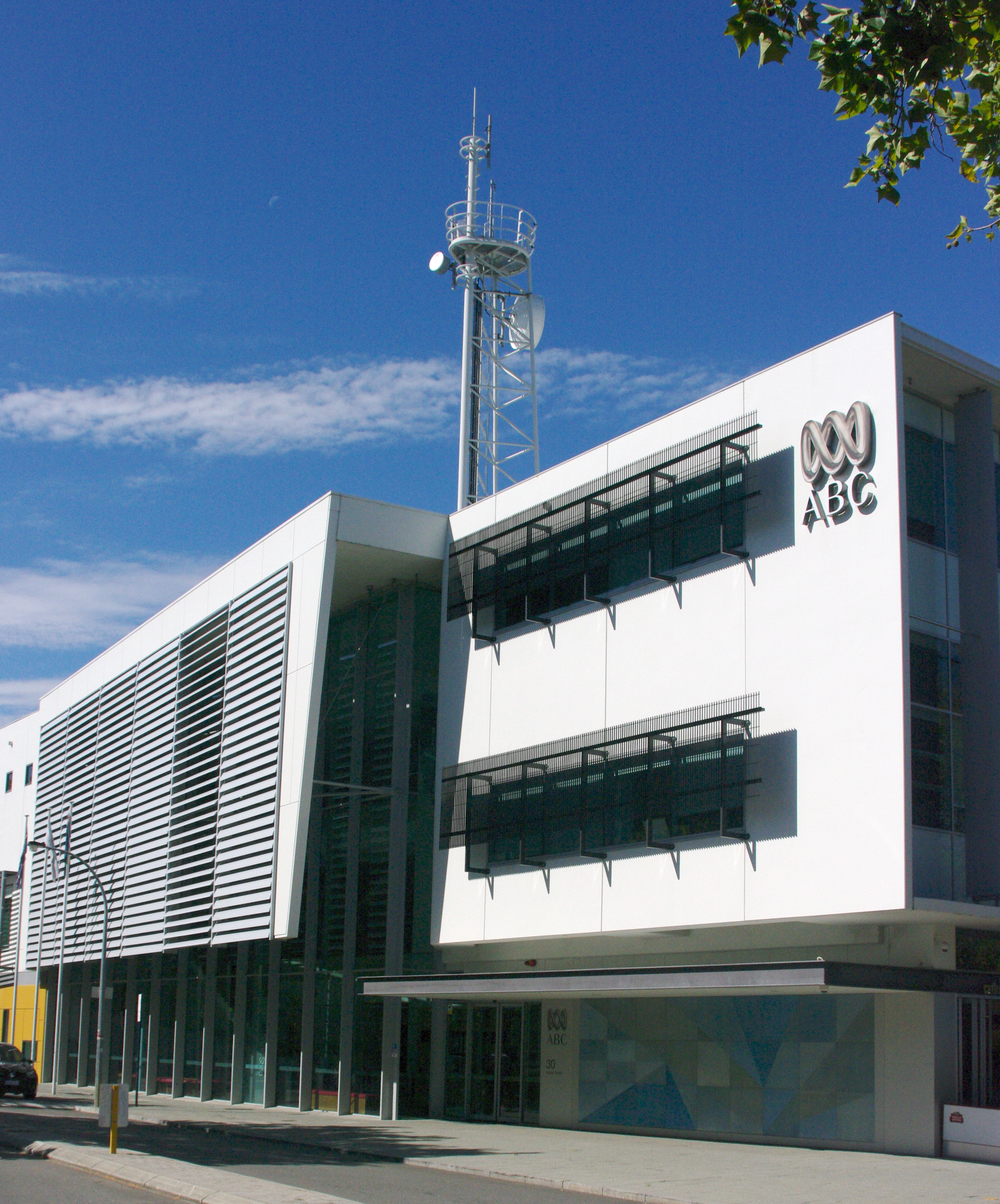
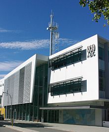 ABC studios in East Perth
Metropolitan Perth has six broadcast television stations;
- ABC WA. Produces nightly local news at 7 pm and weeknightly national current affairs from 7:30 pm to 8 pm. (digital and analogue) (callsign: ABW – Channel 2 Analogue, Channel 12 Digital)
- SBS WA (digital and analogue) (callsign: SBS – Channel 28 Analogue, Channel 29 Digital)
- Seven Network Perth. Produces weeknightly local news and current affairs from 6 pm to 7 pm. (digital and analogue) (callsign: TVW – Channel 7 Analogue, Channel 6 Digital)
- Nine Network Perth. Produces nightly local news from 6 pm to 6.30 pm and weeknightly national current affairs from 6:30 pm to 7 pm. (digital and analogue) (callsign: STW – Channel 9 Analogue, Channel 8 Digital)
- Network Ten Perth. Produces weeknightly local news from 5 pm – 6.30 pm, weeknightly new national current affairs from 6:30pm to 7pm. (digital and analogue) (callsign: NEW – Channel 10 Analogue, Channel 11 Digital)
- West TV. A free-to-air digital only community television channel that began broadcasting in April 2010. (digital channel 44)
- Access 31. Was a community service channel. (analogue-only) (callsign: ATW – Channel 31 Analogue) – ceased transmission in August 2008, with assets liquidated.[29][30]
In addition, broadcasters operate digital multichannels:
- ABC2 (carried by ABW)
- ABC3 (carried by ABW)
- ABC News 24 (carried by ABW)
- SBS Two (carried by SBS)
- SBS HD (carried by SBS)
- 7mate (carried by TVW)
- 7Two (carried by TVW)
- GEM (carried by STW)
- GO! (carried by STW)
- Eleven (carried by NEW)
- One HD (carried by NEW)
Regional WA has a similar availability of stations, with the exception of West TV in all areas but Bunbury and Albany. The metropolitans commercial stations are affiliated with:
- Golden West Network (GWN7). Produces weeknightly local news from 5.30 pm to 6 pm, also airs Seven Perth news until 7 pm) (analogue only) (callsign: SSW South West, VEW Goldfields/Esperance, GTW Central West, WAW Statewide)
- WIN Television WA. Produces weeknightly local news from 5:30 pm – 6 pm, live from Perth. Also airs Nine Perth news from 6 pm – 6:30 pm. (analogue only) (callsign: WOW)
- Ten West. A joint venture between GWN and WIN to provide Ten to regional WA. It is a direct feed of NEW-10 with local ads inserted. Since it is a digital only channel it is being progressively rolled out statewide which hopes to see most of the population covered by 31 December 2010.
Pay TV services are provided by Foxtel, which acquired many of the assets and all the remaining subscribers of the insolvent Galaxy Television satellite service in 1998. Some metropolitan suburbs are serviced by Pay TV via cable; however, most of the metropolitan and rural areas can only access Pay TV via satellite.
Radio
Perth has many radio stations on both AM and FM frequencies. ABC stations include ABC NewsRadio (6PB 585 am), 720 ABC Perth (6WF 720 am), ABC Radio National (6RN 810 am), ABC Classic FM (6ABC 97.7FM) and Triple J (6JJJ 99.3FM). The six commercial stations are: FM 92.9 (6PPM), Nova 93.7 (6PER), Mix 94.5 (6MIX), 96fm (6NOW), and AM 882 (6PR), and AM 1080 (6IX).
The leading community stations are 6RTR FM 92.1 and Sonshine FM 98.5 (6SON).
Culture
Wine
Main article: West Australian wineAustralia’s biggest state extends the western third of the continent, although the winemaking regions are almost entirely concentrated in the cooler climate south-western portion of the State. Western Australia produces less than 5% of the country's wine output, however in quality terms it is very much near the top.[31][32][33][34] Major wine producing regions include: Margaret River, The Great Southern, Swan Valley as well as several smaller districts including Blackwood Valley, Manjimup, Pemberton, Peel, Chittering Valley, Perth Hills, and Geographe.[33]
Sport
Main article: Sport in Western AustraliaA number of national or international sporting teams and events are based in the state, including:
- Australian rules football: The West Coast Eagles and the Fremantle Dockers in the AFL. The WAFL is the main local football competition, but other local and district football leagues are exist across the state.
- Baseball: Perth Heat (men)
- Basketball: Perth Wildcats (men) and West Coast Waves (women)
- Cricket: Western Warriors (men) and Western Fury (women)
- Field hockey: WA Thundersticks (men) and Smokefree WA Diamonds (women)
- Netball: West Coast Fever (women)
- Rugby league: Western Reds (men)
- Rugby union: Western Force (men)
- Soccer: Perth Glory (men) and Perth Glory (W-League)
International events hosted by Western Australia include the Hopman Cup, the Tom Hoad Cup, the Perth Cup, Red Bull Air Race and the Gravity Games.
The Arts
Western Australia is home to one of the country's leading performance training institutions, the acclaimed Western Australian Academy of Performing Arts (WAAPA), as well as a burgeoning theatrical and musical scene. Notable musicians and bands to have been born in or lived in Western Australia include Adam Brand, Karnivool, Birds of Tokyo, Bon Scott, Eskimo Joe, Johnny Young, Gyroscope, the John Butler Trio, Tame Impala, Kevin Mitchell, The Kill Devil Hills, Pendulum, The Pigram Brothers, Rolf Harris and The Triffids. The West Australian Music Industry Awards (WAMis) have been awarded every year to the leading musicians and performers in WA since 2001.
Notable actors and television personalities from Western Australia include Heath Ledger, Hugh Jackman, Sam Worthington, Ernie Dingo, Jessica Marais, Megan Gale, Rove McManus, Isla Fisher, and Melissa George. Films and television series filmed or partly filmed in Western Australia include Cloudstreet, Australia, Bran Nu Dae, ABBA: the Movie and Last Train to Freo.
The West Australian Symphony Orchestra (WASO) is based at the Perth Concert Hall. Other concert and performance venues in Western Australia include His Majesty's Theatre and the defunct Perth Entertainment Centre. Perth Arena, set to open in 2012, will host concerts and indoor sporting events.
See also
Lists:
- List of Western Australian towns
- List of highways in Western Australia
- List of statues in Western Australia
- Local Government Areas of Western Australia
References
- ^ "3101.0 – Australian Demographic Statistics, June 2010". ABS. 21 December 2010. http://www.abs.gov.au/ausstats/abs@.nsf/mf/3101.0/. Retrieved 21 December 2010.
- ^ 5220.0 – Australian National Accounts: State Accounts, 2009–10.
- ^ "The Floral Emblem of Western Australia". Department of the Premier and Cabinet, Government of Western Australia. http://www.dpc.wa.gov.au/index.cfm?event=symbolsWaFloral. Retrieved 13 June 2008.
- ^ 'West Australia' and its related demonym 'West Australia' are occasionally used, but can be considered incorrect. 'Western Australia' is always used in an official sense, never West Australia. The terms 'Westralia' and 'Westralian' were regularly used in the 19th and 20th century – see [1] and [2]. The terms are still found in the names of certain companies and buildings, eg. Westralia House in Perth and Westralia Airports Corporation, which operates Perth Airport, as well as in the names of several ships – see http://henrietta.liswa.wa.gov.au/record=b2140613~S2 and http://henrietta.liswa.wa.gov.au/record=b1791098~S2.
- ^ a b In Australia, the body of water south of the continent is officially gazetted as the Southern Ocean, whereas the International Hydrographic Organization (IHO) designates it as part of the Indian Ocean. See IHO Limit of Oceans and Seas and Article
- ^ http://www.ausstats.abs.gov.au/ausstats/subscriber.nsf/0/34CE7FFF9776F3F1CA2574B30017CFB2/$File/13500_sep%202008.pdf
- ^ "State And Territory Borders". Geoscience Australia. 11 September 2007. Archived from the original on 28 November 2007. http://web.archive.org/web/20071128113204/http://www.ga.gov.au/education/facts/dimensions/borders.htm. Retrieved 25 September 2008.
- ^ "Australian Coastlines". Geoscience Australia. 7 August 2003. Archived from the original on 30 July 2008. http://web.archive.org/web/20080730134738/http://www.ga.gov.au/education/facts/dimensions/coastlin.htm. Retrieved 25 September 2008.
- ^ "Area of States and Territories". Geoscience Australia. 31 August 2005. Archived from the original on 30 July 2008. http://web.archive.org/web/20080730134442/http://www.ga.gov.au/education/facts/dimensions/areadime.htm. Retrieved 25 September 2008.
- ^ "Climate of Western Australia". Bureau of Meteorology. http://www.bom.gov.au/lam/climate/levelthree/ausclim/ausclimwa.htm. Retrieved 6 December 2009.
- ^ "How extreme south-west rainfalls have changed" (PDF). Indian Ocean Climate Initiative. 2000. http://www.water.wa.gov.au/Tools/Water+Education+Tools/Resources/Downloads_GetFile.aspx?id=931. Retrieved 16 May 2009.
- ^ Snow in Western Australia: About Snow in WA. Retrieved 4 February 2007.
- ^ "Rainfall and Temperature Records: National" (PDF). Bureau of Meteorology. http://www.bom.gov.au/climate/extreme/records/national.pdf. Retrieved 14 November 2009.
- ^ "Current Statistics – Vascular Flora". Western Australian Flora Statistics. Flora Base. http://florabase.calm.wa.gov.au/statistics/. Retrieved 30 August 2008.
- ^ Tauman, Merab Harris (1988). "O'Connor, Charles Yelverton (1843–1902)". Australian Dictionary of Biography, Volume 1. MUP. pp. 51–54. http://www.adb.online.anu.edu.au/biogs/A110059b.htm. Retrieved 12 July 2008.
- ^ a b "2006 Census QuickStats: Western Australia, October 2007". Censusdata.abs.gov.au. http://www.censusdata.abs.gov.au/ABSNavigation/prenav/ViewData?&action=401&tabname=Summary&areacode=5&issue=2006&producttype=QuickStats&textversion=true&navmapdisplayed=true&&breadcrumb=PLD&. Retrieved 14 June 2010.
- ^ "Estimated Resident Population, WA". ABS. 31 March 2008. http://www.abs.gov.au/AUSSTATS/abs@.nsf/DetailsPage/3218.02006-07?OpenDocument. Retrieved 16 September 2008.
- ^ "Department of Mines and Petroleum". WA Department of Mines and Petroleum. 9 November 2011. http://www.dmp.wa.gov.au/7846.aspx. Retrieved 9 November 2011.
- ^ "Australian Bureau of Statistics". WA Australian Bureau of Statistics. 9 November 2011. http://www.abs.gov.au/AUSSTATS/abs@.nsf/Lookup/1301.0Chapter18012009%E2%80%9310. Retrieved 9 November 2011.
- ^ "Australian National Accounts: State Accounts, 2008–09". Abs.gov.au. http://www.abs.gov.au/AUSSTATS/abs@.nsf/mf/5220.0. Retrieved 14 June 2010.
- ^ "Structure of the WA Economy". WA Department of Treasury and Finance. 24 January 2006. http://www.dtf.wa.gov.au/cms/uploadedFiles/structure_wa_economy_2005.pdf. Retrieved 10 September 2008.
- ^ "Australian Economic Indicators". Australian Bureau of Statistics. 2008. http://www.ausstats.abs.gov.au/ausstats/subscriber.nsf/0/34CE7FFF9776F3F1CA2574B30017CFB2/$File/13500_sep%202008.pdf. Retrieved 11 September 2008.
- ^ a b "2008 Crop Report". ABARE. 1 June 2008. http://abare.gov.au/publications_html/cr/cr_08/cr08_June.pdf. Retrieved 13 September 2008.
- ^ a b "WA at a Glance 2008". Australian Bureau of Statistics. 2 April 2008. http://www.ausstats.abs.gov.au/ausstats/subscriber.nsf/0/EFF65DC1D23D314FCA25741D000DC292/$File/13065_2008_reissue.pdf. Retrieved 10 September 2008.
- ^ "2008 Live Exports". ABARE. 31 March 2008. http://abare.gov.au/publications_html/livestock/livestock_08/LiveExports.pdf. Retrieved 15 September 2008.
- ^ www.gowestnow.com "Go West Now". Government of Western Australia. 2008. http://www.gowestnow.com www.gowestnow.com. Retrieved 16 September 2008.
- ^ "Downstream_Petroleum 2007 Report". Australian Institute of Petroleum. 15 July 2008. http://www.aip.com.au/pdf/Downstream_Petroleum_2007_Report.pdf. Retrieved 12 September 2008.
- ^ Review Essay, New Federation History, Melbourne University Law Review www.austlii.edu.au
- ^ Access 31 has closed down, Australian-Media.com.au
- ^ Access 31 shut down[dead link]
- ^ Hugh Johnson & Jancis Robinson (2007). The World Atlas of Wine; 6th Revised edition edition. Mitchell Beazley. ISBN 978-1845334147.
- ^ T. Stevenson "The Sotheby's Wine Encyclopedia" pg 589 Dorling Kindersley 2005 ISBN 0756613248
- ^ a b Australian Wine and Brandy corporation – Western Australia
- ^ winepros.com.au, The Oxford Companion to Wine pg 765 Western Australia
External links
- Welcome to Western Australia, a tourist website run by Tourism Western Australia, the statutory authority responsible for promoting Western Australia as a tourist destination
- Western Australia government's website
Western Australia General Economy · Energy · Flag · Geography · Geology · Government · History · Local Government · Parliament · People · Police · Politics · Rail transport · Regions · Sport
Regions Gascoyne · Goldfields-Esperance · Great Southern · Kimberley · Mid West · Peel · Pilbara · South West · WheatbeltCities and
townsWestern Australia portal States and territories of Australia States and mainland
territories
External territories Former territories Categories:- Western Australia
- Former British colonies
- States and territories of Australia
- States and territories established in 1890


Wikimedia Foundation. 2010.