- Angel Island (California)
-
Angel Island 
Angel IslandGeography Location San Francisco Bay Coordinates 37°52′N 122°26′W / 37.86°N 122.43°WCoordinates: 37°52′N 122°26′W / 37.86°N 122.43°W Area 1.2 sq mi (3.1 km2) Highest elevation 788 ft (240.2 m) Highest point Mount Caroline Livermore Country United StatesState California County Marin County
San Francisco CountyDemographics Population 57 Density 18.35 /km2 (47.53 /sq mi) Angel Island is an island in San Francisco Bay that offers expansive views of the San Francisco skyline, the Marin County Headlands and Mount Tamalpais. The entire island is included within Angel Island State Park, and is administered by California State Parks. It has been used for a variety of purposes, including military forts and immigration centers. The Immigration Station on the northeast corner of the island processed approximately one million immigrants and has been designated a National Historic Landmark.[1]
Contents
Geography
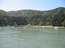
 Port of Angel Island
The highest point on the island, almost exactly at its center, is Mount Caroline Livermore at a height of 788 feet (240 m). The island is almost entirely in Marin County, California, although, there is a small sliver (0.7%) at the eastern end of it (Fort McDowell) which extends into the territory of San Francisco County. The island is separated from the mainland of Marin County by Raccoon Strait. The United States Census Bureau reported a land area of 3.107 km² (1.2 sq mi) and a population of 57 persons as of the 2000 census.[2]
History
 Ayala Cove, on the north side of Angel Island.
 Angel Island as seen from Tiburon.
 San Francisco skyline & Alcatraz from Angel Island
Until about ten thousand years ago, Angel Island was connected to the mainland; it was cut off by the rise in sea levels due to the end of the last ice age. From about two thousand years ago the island was a fishing and hunting site for Coast Miwok Native Americans. Similar evidence of Native American settlement is found on the nearby mainland of the Tiburon Peninsula upon Ring Mountain.[3] In 1775, the Spanish naval vessel San Carlos made the first European entry to the San Francisco Bay under the command of Juan de Ayala. Ayala anchored off Angel Island, and gave it its modern name (Isla de los Angeles); the bay where he anchored is now known as Ayala Cove.
Like much of the California coast, Angel Island was subsequently used for cattle ranching. In 1863, during the American Civil War, the U.S. Army established a camp on the island (now known as Camp Reynolds or the West Garrison), and it subsequently became an infantry garrison during the US campaigns against Native American peoples in the West.[4]
Fort McDowell
In the later nineteenth century, the army designated the entire island as "Fort McDowell" and developed further facilities there, including what is now called the East Garrison or Camp McDowell. A quarantine station was opened in Ayala Cove (which at the time was known as Hospital Cove) in 1891. During the Spanish–American War the island served as a discharge depot for returning troops. It continued to serve as a transit station throughout the first half of the twentieth century, with troops engaged in World War I embarking and returning there.
During World War II the need for troops in the Pacific far exceeded prior needs. The facilities on Angel Island were expanded and further processing was done at Fort Mason in San Francisco. Prior to the war the infrastructure had been expanded including building the Army ferry General Frank M. Coxe, which transported troops to and from Angel Island on a regular schedule.
Japanese and German POWs were also held on the island, supplanting the immigration needs which were curtailed during the war years.
The army decommissioned the island in 1946, but returned to the southern point in the 1950s when a Nike missile base was constructed. However, this was decommissioned as obsolete in 1962.
Immigration station
Main article: United States Immigration Station, Angel Island Camp Reynolds (West Garrison) on Angel Island.
From 1910 to 1940, the Angel Island Immigration Station processed approximately 1 million Asian immigrants entering into the US, leading to it sometimes being referred to as "The Ellis Island of the West". Due to the restrictions of the Chinese Exclusion Act of 1882, many immigrants spent years on the island, waiting for entry. A fire destroyed the administration building in 1940, and subsequent immigration processing took place in San Francisco.
In 1962, the Chinese American community successfully lobbied the State of California to designate the immigration station as a State Landmark. Today, the Angel Island Immigration Station is a federally designated National Historic Landmark. It was renovated by the California State Parks,with a re-opening February 16, 2009.
Modern use
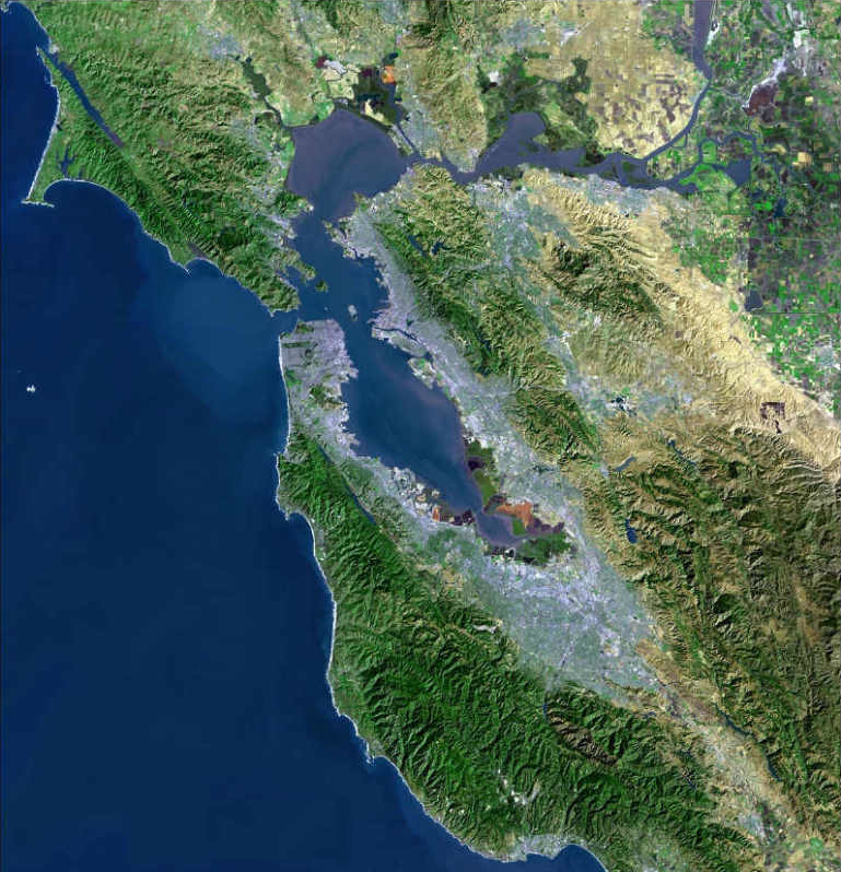
 Aerial view of Angel Island
In 1938, hearings concerning charges of membership in a proscribed political party against labor leader Harry Bridges were held on Angel Island before Dean James Landis of Harvard Law School. After eleven weeks of testimony that filled nearly 8,000 pages, Landis found in favor of Bridges. The decision was accepted by the United States Department of Labor and Bridges was freed.[citation needed]
In 1954, the State Park Commission authorized California State Parks to purchase 37 acres (15 ha) around Ayala Cove, marking the birth of Angel Island State Park. Additional acreage was purchased four years later, in 1958. The last federal Department of Defense personnel withdrew in 1962, turning over the entire island as a state park in December of the same year.
There is one active United States Coast Guard lighthouse on the island at Point Blunt. The lighthouse at Point Stuart has been disestablished.
2008 fire
 The fire at about 7 a.m. on October 13, 2008
 A helicopter, faintly visible amid smoke near center of image, drops water on the wildfire in the morning on October 13, 2008.
On October 12, 2008 at approximately 9:00 p.m. PDT, a fire visible from all around the San Francisco Bay broke out on the island that spread to an estimated 100 acres (40 ha) within an hour.[5] By 8:00 a.m. the next morning, the fire had scorched 250 acres (100 ha) – a third of the island – and was 20 percent contained.
Firefighters were ferried from the mainland and helicopters dropped water and fire retardants to protect the historical buildings and extinguish the fire that was fully contained by October 14, 2008 at approximately 7:00 p.m.[6]
Root and branch extirpation of non-native flora is underway in an effort to restore the original oak woodland and grassland biome. Prior to the introduction of the relatively flammable eucalyptus, the only fires recorded were on building structures. Since then, there have been several other fires including one in 2005 that burned 25 acres (10 ha), and a smaller 2–3-acre blaze in 2004.[7]
Access
Access to the island is by private boat or public ferry from San Francisco, Tiburon or Vallejo. Ferry services are reduced during the winter.
Bicycles can be brought to the island on the ferry and used on the island's main roads. Bikes and Segways can also be rented. Dogs are not allowed. Roller skates and skateboards are prohibited. No wood fires are allowed but there are designated barbecue and picnic areas available to use. A few campsites are also available for reservation. Night travel on the island is prohibited in some areas for reasons of park security and public safety.
See also
- Islands of San Francisco Bay
- List of California state parks
- Hornblower Cruises
References
- ^ The National Register of Historic Places (Thursday, 16 August 2007). "Celebrating Asian Heritage". National Park Service. http://www.nps.gov/history/nr/feature/asia/1999/angel.htm. Retrieved 11 June 2010.
- ^ "Detailed Tables: Block Group 3, Census Tract 1242, Marin County; and Block 1068, Block Group 1, Census Tract 179.02, San Francisco County". American FactFinder. United States Census Bureau. 2000. http://factfinder.census.gov/servlet/DTTable?_bm=y&-show_geoid=Y&-tree_id=4001&-_showChild=Y&-context=dt&-errMsg=&-all_geo_types=N&-mt_name=DEC_2000_SF1_U_P001&-redoLog=false&-transpose=N&-search_map_config=. Retrieved 11 June 2010.
- ^ C. Michael Hogan (2008). "Ring Mountain - Carving in United States in The West". The Megalithic Portal. http://www.megalithic.co.uk/article.php?sid=19244. Retrieved 11 June 2010.
- ^ John Soennichsen (Sunday, 13 January 2008). "Historic California Posts: Fort McDowell (Camp Reynolds, Post of Angel Island)". The California State Military Museum. http://www.militarymuseum.org/CpReynolds.html. Retrieved 11 June 2010.
- ^ Adam Jackson (Monday, 13 October 2008). "Angel Island San Francisco on Fire! (links)". Adam and Laura Go West. http://adamandlauragowest.com/?p=141. Retrieved 11 June 2010.
- ^ Demian Bulwa; Kevin Fagan; Jim Doyle (Tuesday, 14 October 2008). "Wildfire transforms Angel Island". The San Francisco Chronicle. http://www.sfgate.com/cgi-bin/article.cgi?f=/c/a/2008/10/13/BASR13G48J.DTL. Retrieved 11 June 2010.
- ^ Mark Prado; Jennifer Upshaw (Monday, 13 October 2008). "All-out attack as firefighters work to save Angel Island". The Marin Independent Journal. http://www.marinij.com/marinnews/ci_10713017?source=pkg. Retrieved 11 June 2010.
Further reading
- Lai, Him Mark; Lim, Genny; Yung, Judy (1980). Island: Poetry and History of Chinese Immigrants on Angel Island, 1910-1940. Seattle: University of Washington. ISBN 0295971096.
- Soennichsen, John (2005). Miwoks to Missiles. Tiburon, California: Angel Island Association. ISBN 0966735226.
External links
- Angel Island State Park
- Angel Island Association non-profit partner
- Angel Island Company state park concessionaire
Protected areas of California National Park System National Parks National Preserves National Monuments Cabrillo · Devils Postpile · Lava Beds · Muir Woods · Pinnacles · World War II Valor in the Pacific National MonumentNational Seashores National Historical Parks National Historic Sites National Memorials Port Chicago Naval MagazineNational Recreation Areas National Forests National Forests Angeles · Cleveland · Eldorado · Inyo · Klamath · Lassen · Los Padres · Mendocino · Modoc · Plumas · San Bernardino · Sequoia · Shasta-Trinity · Sierra · Six Rivers · Stanislaus · TahoeNational Wilderness
Preservation SystemAgua Tibia · Ansel Adams · Bucks Lake · Caribou · Carson-Iceberg · Castle Crags · Cucamonga · Desolation · Dick Smith · Dinkey Lakes · Emigrant · Golden Trout · Hoover · Inyo Mountains · Ishi · Jennie Lakes · John Muir · Kaiser · Marble Mountain · Mokelumne · Mount Shasta Wilderness · North Fork · San Gabriel · Sanhedrin · San Jacinto · San Rafael · Sespe · Siskiyou · Snow Mountain · South Fork Eel River · South Sierra · South Warner · Thousand Lakes · Trinity Alps · Ventana · Yolla Bolly-Middle Eel · YukiOther State Forests Boggs Mountain Demonstration · Ellen Pickett · Jackson Demonstration · Las Posadas · LaTour Demonstration · Mount Zion · Mountain Home Demonstration · Soquel Demonstration
National Wildlife Refuges Antioch Dunes · Bitter Creek · Blue Ridge · Butte Sink · Castle Rock · Clear Lake · Coachella Valley · Colusa · Delevan · Don Edwards San Francisco Bay · Ellicott Slough · Farallon · Guadalupe-Nipomo Dunes · Hopper Mountain · Humboldt Bay · Kern · Lower Klamath · Marin Islands · Merced · Modoc · Pixley · Sacramento · Sacramento River · Salinas River · San Diego Bay · San Diego · San Joaquin River · San Luis · San Pablo Bay · Seal Beach · Sonny Bono Salton Sea · Stone Lakes · Sutter · Tijuana Slough · Tule LakeState Wildlife Areas Wildlife Areas Antelope Valley · Ash Creek · Bass Hill · Battle Creek · Big Lagoon · Big Sandy · Biscar · Butte Valley · Buttermilk Country · Cache Creek · Camp Cady · Cantara/Ney Springs · Cedar Roughs · Cinder Flats · Collins Eddy · Colusa Bypass · Coon Hollow · Cottonwood Creek · Crescent City Marsh · Crocker Meadows · Daugherty Hill · Decker Island · Doyle · Dutch Flat · Eastlker River · Eel River · Elk Creek Wetlands · Elk River · Fay Slough · Feather River · Fitzhugh Creek · Fremont Weir · Grass Lake · Gray Lodge · Green Creek · Grizzly Island · Hallelujah Junction · Heenan Lake · Hill Slough · Hollenbeck Canyon · Honey Lake · Hope Valley · Horseshoe Ranch · Imperial · Indian Valley · Kelso Peak and Old Dad Mountains · Kinsman Flat · Knoxville · Laguna · Lake Berryessa · Lake Earl · Lake Sonoma · Little Panoche Reservoir · Los Banos · Lower Sherman Island · Mad River Slough · Marble Mountains · Mendota · Merrill's Landing · Miner Slough · Monache Meadows · Morro Bay · Moss Landing · Mouth of Cottonwood Creek · Napa-Sonoma Marshes · North Grasslands · O'Neill Forebay · Oroville · Petaluma Marsh · Pickel Meadow · Pine Creek · Point Edith · Putah Creek · Rector Reservoir · Red Lake · Rhode Island · Sacramento River · San Felipe Valley · San Jacinto · San Luis Obispo · San Luis Reservoir · San Pablo Bay · Santa Rosa · Shasta Valley · Silver Creek · Slinkard/Little Antelope · Smithneck Creek · South Fork · Spenceville · Surprise Valley · Sutter Bypass · Tehama · Truckee River · Upper Butte Basin · Volta · Warner Valley · Waukell Creek · West Hilmar · Westlker River · White Slough · Willow Creek · Yolo BypassEcological Reserves Albany Mudflats · Alkali Sink · Allensworth · Atascadero Creek Marsh · Bair Island · Baldwin Lake · Batiquitos Lagoon · Blue Sky · Boden Canyon · Boggs Lake · Bolsa Chica · Bonny Doon · Buena Vista Lagoon · Butler Slough · Butte Creek Canyon · Butte Creek House · Buttonwillow · By Day Creek · Calhoun Cut · Canebrake · Carlsbad Highlands · Carmel Bay · Carrizo Canyon · Carrizo Plains · China Point · Clover Creek · Coachella Valley · Coal Canyon · Corte Madera Marsh · Crestridge · Dairy Mart Ponds · Dales Lake · Del Mar Landing · Eden Landing · Elkhorn Slough · Estelle Mountain · Fall River Mills · Fish Slough · Fremont Valley · Goleta Slough · Indian Joe Spring · Kaweah · Kerman · King Clone · Laguna Laurel · Loch Lomond Vernal Pool · Lokern · Magnesia Spring · Marin Islands · Mattole River · McGinty Mountain · Morro Dunes · Morro Rock · Napa River · North Table Mountain · Oasis Spring · Panoche Hills · Peytonia Slough · Pine Hill · Piute Creek · Pleasant Valley · Point Lobos · Rancho Jamul · Redwood Shores · River Springs Lakes · Saline Valley · San Dieguito Lagoon · San Elijo Lagoon · San Felipe Creek · San Joaquin River · Santa Rosa Plateau · Springville · Stone Corral · Sycamore Canyon · Sycuan Peak · Thomes Creek · Tomales Bay · Upper Newport Bay · Watsonville Slough · West Mojave Desert · Woodbridge · YaudanchiMarine Protected Areas Abalone Cove · Agua Hedionda Lagoon · Albany Mudflats · Anacapa · Anacapa · Año Nuevo · Asilomar · Atascadero Beach · Bair Island · Batiquitos Lagoon · Big Creek · Big Creek · Big Sycamore Canyon · Bodega · Bolsa Chica · Buena Vista Lagoon · Cambria · Cardiff and San Elijo · Carmel Bay · Carmel Pinnacles · Carrington Point · Catalina Marine Science Center · Corte Madera Marsh · Crystal Cove · Dana Point · Del Mar Landing · Doheny · Doheny · Duxbury Reef · Edward F. Ricketts · Elkhorn Slough · Elkhorn Slough · Encinitas · Estero de Limantour · Fagan Marsh · Farallon Islands · Farnsworth Bank · Fort Ross · Gerstle Cove · Goleta Slough · Greyhound Rock · Gull Island · Harris Point · Heisler Park · Hopkins · Irvine Coast · James V. Fitzgerald · Judith Rock · Julia Pfeiffer Burns · La Jolla · Laguna Beach · Lovers Cove (Catalina Island) · Lovers Point · MacKerricher · Manchester and Arena Rock · Marin Islands · Mia J. Tegner · Moro Cojo Slough · Morro Bay · Morro Bay · Morro Beach · Natural Bridges · Niguel · Pacific Grove Marine Gardens · Painted Cave · Peytonia Slough · Piedras Blancas · Piedras Blancas · Pismo · Pismo-Oceano Beach · Point Buchon · Point Buchon · Point Cabrillo · Point Fermin · Point Lobos · Point Reyes Headlands · Point Sur · Point Sur · Portuguese Ledge · Punta Gorda · Redwood Shores · Refugio · Richardson Rock · Robert E. Badham · Robert W. Crown · Russian Gulch · Russian River · Salt Point · San Diego-Scripps · San Dieguito Lagoon · San Elijo Lagoon · Santa Barbara Island · Scorpion · Skunk Point · Sonoma Coast · Soquel Canyon · South Laguna Beach · South Point · Tomales Bay · Upper Newport Bay · Van Damme · Vandenberg · White Rock (Cambria)National Landscape Conservation System National Monuments National Conservation Areas California Desert · King RangeWilderness Areas Argus Range · Big Maria Mountains · Bigelow Cholla Garden · Bighorn Mountain · Black Mountain · Bright Star · Bristol Mountains · Cadiz Dunes · Carrizo Gorge · Chemehuevi Mountains · Chimney Peak · Chuckwalla Mountains · Chumash · Cleghorn Lakes · Clipper Mountain · Coso Range · Coyote Mountains · Darwin Falls · Dead Mountains · Dick Smith · El Paso Mountains · Fish Creek Mountains · Funeral Mountains · Golden Valley · Grass Valley · Headwaters Forest Reserve · Hollow Hills · Ibex · Indian Pass · Inyo Mountains · Jacumba · Kelso Dunes · Kiavah · Kingston Range · Little Chuckwalla Mountains · Little Picacho · Machesna Mountain · Matilija · Malpais Mesa · Manly Peak · Mecca Hills · Mesquite · Newberry Mountains · Nopah Range · North Algodones Dunes · North Mesquite Mountains · Old Woman Mountains · Orocopia Mountains · Otay Mountain · Owens Peak · Pahrump Valley · Palen/McCoy · Palo Verde Mountains · Picacho Peak · Piper Mountain · Piute Mountains · Red Buttes · Resting Spring Range · Rice Valley · Riverside Mountains · Rodman Mountains · Sacatar Trail · Saddle Peak Hills · San Gorgonio · Santa Lucia · Santa Rosa · Sawtooth Mountains · Sespe · Sheephole Valley · South Nopah Range · Stateline · Stepladder Mountains · Surprise Canyon · Sylvania Mountains · Trilobite · Turtle Mountains · Whipple Mountains ·National Marine Sanctuaries National Estuarine Research Reserves Elkhorn Slough · San Francisco Bay · Tijuana River Estuary
University of California Natural Reserve System Año Nuevo Island · Bodega Marine · Box Springs · Boyd Deep Canyon Desert Research Center · Burns Piñon Ridge · Carpinteria Salt Marsh · Chickering American River · Coal Oil Point · Dawson Los Monos Canyon · Eagle Lake Field Station · Elliott Chaparral · Emerson Oaks · Fort Ord · Hastings · James San Jacinto Mountains · Jenny Pygmy Forest · Jepson Prairie · Kendall-Frost Mission Bay Marsh · Kenneth S. Norris Rancho Marino · Landels-Hill Big Creek · McLaughlin · Motte Rimrock · Quail Ridge · Sagehen Creek Field Station · San Joaquin Freshwater Marsh · Santa Cruz Island · Scripps Coastal · Sedgwick · Stebbins Cold Canyon · Steele Burnand Anza-Borrego · Stunt Ranch Santa Monica Mountains · Sweeney Granite Mountains Desert Research Center · Valentine Eastern Sierra · Younger LagoonHeritage registers: World Heritage Sites · World Network of Biosphere Reserves · National Register of Historic Places · National Historic Landmarks · National Natural Landmarks · California Historical Landmarks · California Points of Historical Interest · California Register of Historical Resources
San Francisco attractions Landmarks 49-Mile Drive · Alcatraz · Bay Bridge · Cable Cars · The Castro · Chinatown · City Hall · Cliff House · Coit Tower · F-Market Streetcar · Fairmont Hotel · Federal Reserve Bank · Ferry Building · Fisherman's Wharf · Fort Mason · Fort Point · Ghirardelli Square · Golden Gate Bridge · Grace Cathedral · Haight-Ashbury · Jack Kerouac Alley · Lombard Street · Mark Hopkins Hotel · Market Street · Mission Dolores · Nob Hill · North Beach · Old U.S. Mint · Painted Ladies · Palace of Fine Arts · Pier 39 · Public Library · Sutro Baths · Transamerica Pyramid · Treasure Island · Union Square
Museums & art Asian Art Museum · Aquarium of the Bay · Cable Car Museum · California Academy of Sciences · Palace of the Legion of Honor · Cartoon Art Museum · Chinese Historical Society Museum · Conservatory of Flowers · Contemporary Jewish Museum · de Young Museum · Exploratorium · Haas-Lilienthal House · Musée Mécanique · Museo ItaloAmericano · Museum of Performance & Design · Museum of the African Diaspora · Precita Eyes · Randall Museum · Ripley's Believe It or Not! · SFMOMA · San Francisco Maritime · Railway Museum · USS Pampanito · Wattis Institute for Contemporary Arts · Zeum
Recreation & parks Alamo Square · Angel Island · Candlestick Point · Corona Heights · Crissy Field · Dolores Park · Farallon Islands · Glen Canyon · Golden Gate National Recreation Area · Golden Gate Park · Lake Merced · McLaren Park · Mount Davidson · Ocean Beach · The Presidio · San Francisco Zoo · Stern Grove · Twin Peaks · Yerba Buena Gardens
Entertainment Higher education Sports Food & drink Anchor Steam · Boudin Bakery · Cioppino · Dungeness crab · Ghirardelli · It's-It Ice Cream · Mission burrito · Rice-A-Roni · Sourdough bread (Lactobacillus sanfranciscensis) · Tonga Room & Hurricane Bar · Top of the Mark
Commerce Bechtel · Charles Schwab · Financial District · Gap · McKesson · Metreon · Moscone Center · PG&E · Stonestown Galleria · Wells Fargo · Westfield San Francisco Centre
U.S. National Register of Historic Places Topics Lists by states Alabama • Alaska • Arizona • Arkansas • California • Colorado • Connecticut • Delaware • Florida • Georgia • Hawaii • Idaho • Illinois • Indiana • Iowa • Kansas • Kentucky • Louisiana • Maine • Maryland • Massachusetts • Michigan • Minnesota • Mississippi • Missouri • Montana • Nebraska • Nevada • New Hampshire • New Jersey • New Mexico • New York • North Carolina • North Dakota • Ohio • Oklahoma • Oregon • Pennsylvania • Rhode Island • South Carolina • South Dakota • Tennessee • Texas • Utah • Vermont • Virginia • Washington • West Virginia • Wisconsin • WyomingLists by territories Lists by associated states Other San Francisco Bay watershed Outline Hydrography · Ecology · List of tributaries · List of lakes

Subdivisions Major · San Francisco Bay · Suisun Bay · San Pablo Bay · Minor · Golden Gate · Grizzly Bay · Richardson Bay · San Rafael Bay · Richmond Inner Harbor · San Leandro Bay
Waterways Rivers · San Joaquin · Sacramento · Napa · Guadalupe · Petaluma · Creeks · San Lorenzo · Alameda · Baxter · Berryessa · Cerrito · Codornices · Coyote (Santa Clara) · Coyote (Marin) · San Leandro · San Lorenzo · Schoolhouse · Temescal · Sausal · Redwood · San Mateo · Los Alamitos · Sonoma · San Anselmo · Cascade · Arroyo Corte Madera del Presidio · Middle · San Rafael · Miller · Novato · Rush · San Antonio · Adobe · Washington · Lynch · Lichau · Tolay · Arroyo Seco (Sonoma County) · Carriger/Fowler · Calabazas · Graham · San Francisquito · Yulupa · Bear · Rindler · Blue Rock Springs · Milliken · Pacheco · Grayson · Alhambra · Rodeo · Refugio · Pinole · Garrity · Rheem · Karlson · San Pablo · Castro · Wildcat · Fluvius Innominatus · Marin (Alameda County) · Strawberry · Arroyo de la Laguna · Arroyo del Valle · Arroyo Mocho · Arroyo Las Positas · Arroyo Seco (Alameda County) · South San Ramon · Calaveras · Arroyo Hondo · Smith · Penitencia · Los Gatos · Straits and estuaries · Sacramento – San Joaquin River Delta · Carquinez Strait · Oakland Estuary · Raccoon Strait
Parks
Protected areasDon Edwards San Francisco Bay National Wildlife Refuge · San Pablo Bay National Wildlife Refuge · Eden Landing Ecological Reserve · Hayward Regional Shoreline · Hayward Shoreline Interpretive Center · Crown Memorial State Beach · Eastshore State Park · Point Isabel Regional Shoreline · César Chávez Park · Brooks Island Regional Shoreline · Point Pinole Regional Shoreline · Antioch Dunes National Wildlife Refuge · Coyote Point Park · Middle Harbor Shoreline Park · San Francisco Bay National Estuarine Research Reserve · China Camp State Park · Rush Ranch Open Space Preserve · San Francisco Maritime National Historical Park · San Francisco Bay Trail
Islands
Peninsulas
InfillMajor islands · Alameda · Alcatraz · Angel · Treasure · Yerba Buena · Minor · Brooks · Bair · Bay Farm · Belvedere · Brother · Castro Rocks · Coast Guard · Mare · Red Rock · The Sisters · Marin Islands · Roe · Ryer · Seal Islands · Albany Bulb · Point Isabel · Foster City · Hunters Point
Wetlands Bridges
TunnelsSan Francisco – Oakland Bay Bridge · Richmond – San Rafael Bridge · San Mateo – Hayward Bridge · Dumbarton Bridge · Golden Gate Bridge · Benicia–Martinez Bridge · Antioch Bridge · Carquinez Bridge · Leimert Bridge · Posey and Webster Street Tubes · Transbay Tube
Ports and marinas Port of San Francisco · Port of Oakland · Port of Richmond · Port of Redwood City · Berkeley Marina · Oyster Point Marina/Park · Clipper Yacht Harbor · Foster City Marina (proposed)
Other Discovery Site · Humphrey the Whale · COSCO Busan oil spill · Delta and Dawn · Golden Gate Biosphere Reserve · California Clapper Rail · Reber Plan · San Leandro Oyster Beds · Thicktail chub · Delta smelt · Richmond Shipyards · U.S. Army Corps of Engineers Bay Model · Guadalupe Watershed · Clifton Court Forebay · San Francisco Bay Conservation and Development Commission · The Watershed Project · Save The Bay · Harold Gilliam · Francis P. Filice · Marincello · Citizens for East Shore Parks · Friends of Five Creeks · Urban Creeks Council · Cargill Salt infill
Categories:- American Civil War army posts
- California state parks
- Campgrounds in California
- Government buildings on the National Register of Historic Places in California
- History of immigration to the United States
- History of Marin County, California
- Islands of Marin County, California
- Islands of San Francisco Bay
- Island restoration
- Parks in Marin County, California
- Protected areas established in 1962
- World War II prisoner of war camps in the United States


Wikimedia Foundation. 2010.