- Waterloo, Iowa
-
Waterloo — City — 
East Side of Downtown Waterloo
from the West bank of the Cedar River.Location in the State of Iowa
Coordinates: 42°29′33″N 92°20′46″W / 42.4925°N 92.34611°W Country United States State  Iowa
IowaCounty Black Hawk Incorporated 1868 Government – Mayor Buck Clark Area – City 62.0 sq mi (160.6 km2) – Land 60.7 sq mi (157.3 km2) – Water 1.3 sq mi (3.3 km2) Elevation 883 ft (269 m) Population (2010) – City 68,406 – Rank 5th in Iowa – Density 1,087.3/sq mi (437.0/km2) – Metro 169,895 Time zone CST (UTC−6) – Summer (DST) CDT (UTC−5) ZIP codes 50701-50707 Area code(s) 319 FIPS code 19-82425 GNIS feature ID 468951 Website www.ci.waterloo.ia.us Waterloo is a city in and the county seat of Black Hawk County, Iowa, United States.[1] As of the 2010 United States Census the population decreased by 0.5% to 68,406.[2] Waterloo is part of the Waterloo – Cedar Falls Metropolitan Statistical Area, and is the more populous of the two cities.
Contents
History
Waterloo was originally known as Prairie Rapids Crossing. The town was established, according to the original researcher as reported by staff of the Grout Museum in Waterloo, near two Meskwaki American tribal seasonal camps alongside the Cedar River. It was first settled in 1845 when George and Mary Melrose Hanna and their children arrived on the east bank of the Red Cedar River (now just called the Cedar River). They were followed by the Virden and Mullan families in 1846. Evidence of these earliest families can still be found in the street names Hanna Blvd., Mullan Avenue and Virden Creek.
On December 8, 1845 the Iowa State Register and Waterloo Herald was the first newspaper published in Waterloo.[3]
The name "Waterloo" supplanted the original name, "Prairie Rapids Crossing" shortly after Charles Mullan petitioned for a post office in the town. Since the signed petition did not include the name of the proposed post office location, Mullan was charged with selecting the name when he submitted the petition. Tradition has it that as he flipped through a list of other post offices in the United States, he came upon the name "Waterloo." The name struck his fancy, and on December 29, 1851, a post office was established under that name. The town was later called the same, and Mullan served as the first postmaster from December 29, 1851 until August 11, 1854.
There were two extended periods of rapid growth over the next 115 years. From 1895 to 1915, the population increased from 8,490 to 33,097, a 290% increase. From 1925 to 1960, population increased from 36,771 to 71,755. The 1895 to 1915 period was a time of the rapid growth in manufacturing, rail transportation and wholesale operations. During this period the Waterloo Gasoline Traction Engine Company moved to Waterloo and shortly after Rath Packing Company moved from Dubuque. Another major employer throughout the first two-thirds of the 20th century was the Illinois Central Railroad. Among the others was the less-successful brass era automobile manufacturer, the Maytag-Mason Motor Company.[4]
On June 7, 1934, bank robber Tommy Carroll had a shoot-out with the FBI when he and his wife stopped to pick up gas. Accidentally parking next to a police car and wasting time dropping his gun and picking it back up, Carroll was forced to flee into an alley where he was shot. Carroll was then taken to Allen Memorial Hospital in Waterloo, where he died shortly after.
Waterloo suffered particularly hard in the agricultural recession of the 1980s, due to the major employers at the time being heavily rooted in agriculture. In particular, John Deere, the area's largest employer, cut 10,000 jobs, and the Rath meatpacking plant closed altogether, losing 2500 jobs. It is estimated Waterloo lost 14% of its population during this time.[5] Today the city enjoys a broader industrial base, as city leaders have sought to diversify the industrial and commercial mix. Deere remains a strong presence in the city, but employs only roughly one-third the number of people it did at its peak.
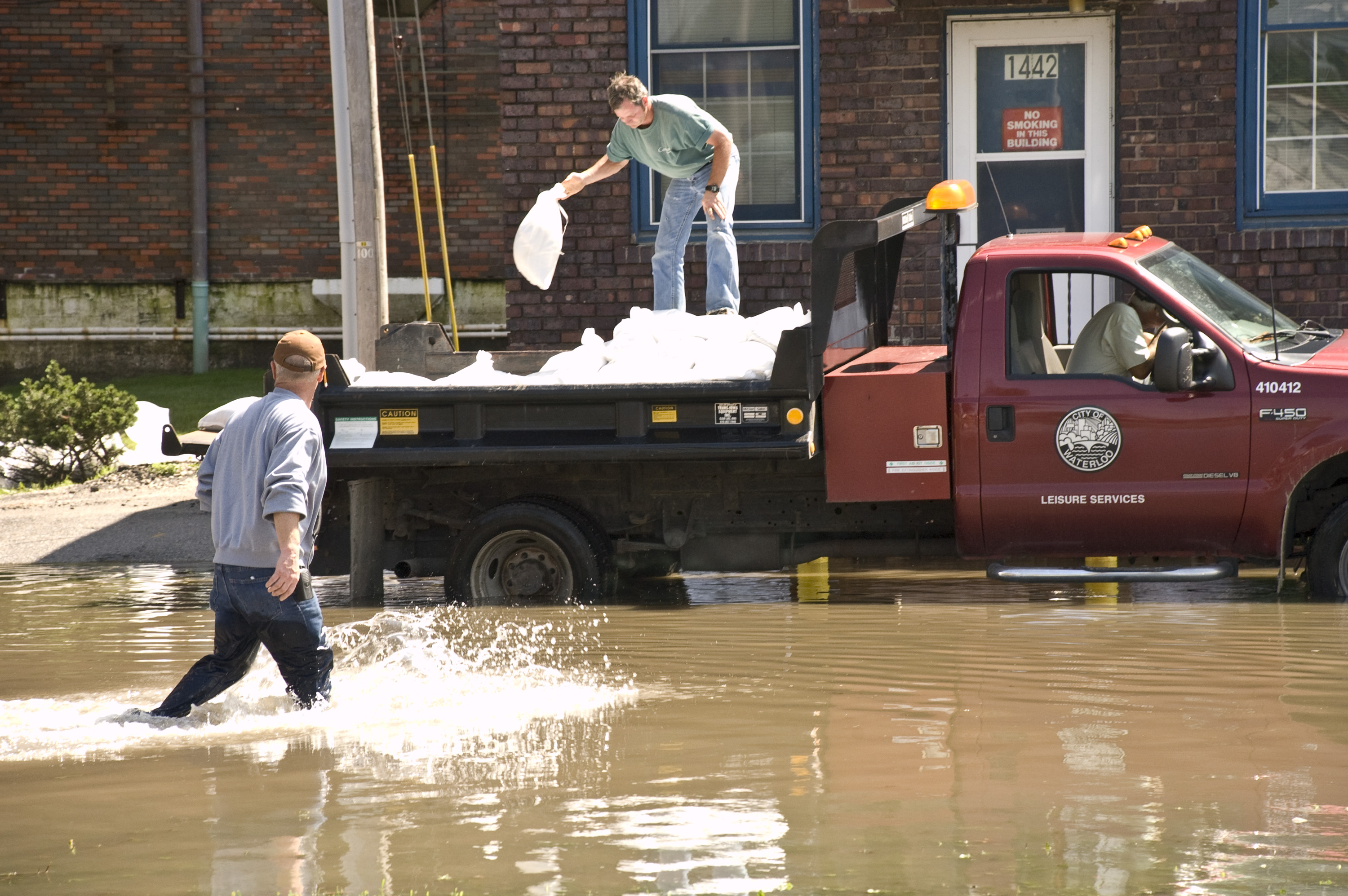
Flood of 2008


June 12, 2008 June 2008 saw the worst flooding in the Waterloo – Cedar Falls area had ever recorded; other major floods include the Great Flood of 1993. The flood control system constructed in the 1970s–90s largely functioned as designed.
For those areas not protected by the system, the Cedar River poured out of its banks and into parking lots, backyards and across the rich Iowa farmland surrounding the city. Although much damage was done, the larger, downstream city of Cedar Rapids was much harder hit.
An area of the west side of the down-town and an area near the former Rath Packing facility were impacted not directly by water coming from the river but were the result of storm run-off draining towards the river but then being trapped on the backside of the flood levy system. These areas did not have lift stations or alternate pumping capacity sufficient to force this water to the river side of the control system. Areas where lift stations had been constructed (Virden Creek and East 7th Street ) to pump this storm run-off into the swollen river remained largely dry (the east and north sides of down-town). Several areas experienced water seeping into basements due to high water-table levels.
- Historical Crests
According to the National Weather Service the ten highest crests of the Cedar River recorded at East 7th Street in downtown Waterloo:[6]
(1) 27.01 ft on June 11, 2008
(2) 21.86 ft on March 29, 1961
(3) 21.67 ft on April 8, 1965
(4) 20.78 ft on July 23, 1999
(5) 20.60 ft on June 2, 1993(6) 20.54 ft on April 2, 1993
(7) 20.15 ft on June 29, 1969
(8) 20.00 ft on March 16, 1929
(9) 19.50 ft on April 2, 1933
(10) 19.26 ft on March 31, 1962Crests reported in the 1960s and prior were before completion of major flood control projects and therefore may not be directly comparable.
Geography
According to the United States Census Bureau, the city has a total area of 62.0 square miles (161 km2), of which, 60.7 square miles (157 km2) of it is land and 1.3 square miles (3.4 km2) of it (2.06%) is water.
The average elevation of Waterloo is 846 feet above sea level. The population density is 1101 people per square mile, considered low for an urban area.[7]
Climate
Monthly Normal, Record High and Low Temperatures, and precipitation Month Jan Feb Mar Apr May Jun Jul Aug Sep Oct Nov Dec Rec High °F 65 66 87 100 94 103 105 105 98 95 80 67 Norm High °F 25.8 31.9 45 59.7 72.2 81.7 85 82.8 75.3 62.5 45 30.7 Norm Low °F 6.3 13.2 24.9 35.8 48.1 58.1 62.2 59.5 49.8 37.8 25.1 12.5 Rec Low °F −41 (−81 wc) −47 −34 −4 22 38 42 38 22 11 −17 −29 Precip (in) 0.84 1.05 2.13 3.23 4.15 4.82 4.2 4.08 2.95 2.49 2.1 1.11 Source: USTravelWeather.com[8] Demographics
Waterloo
Historical PopulationsCensus Pop. %± 1870 4,337 — 1880 5,630 29.8% 1890 6,674 18.5% 1900 12,580 88.5% 1910 26,693 112.2% 1920 36,230 35.7% 1930 46,191 27.5% 1940 51,743 12.0% 1950 65,198 26.0% 1960 71,755 10.1% 1970 75,533 5.3% 1980 75,985 0.6% 1990 66,467 −12.5% 2000 68,747 3.4% 2010 68,406 −0.5% Iowa Data Center Waterloo 2000 Census
As of the 2000 census,[9] there were 68,747 people, 28,169 households, and 17,746 families residing in the city. The population density was 1,131.9 inhabitants per square mile (437.0 /km2). There were 29,499 housing units at an average density of 485.7 per square mile (187.5 /km2). The racial makeup of the city was 79.2% White, 14.5% African American, 1.1% Asian, 1.9% from other races, and 2.0% from two or more races. Hispanic or Latino of any race were 3.2% of the population.
There were 28,169 households out of which 29.0% had children under the age of 18 living with them, 46.0% were married couples living together, 13.3% had a female householder with no husband present, and 37.0% were non-families. 30.0% of all households were made up of individuals and 12.1% had someone living alone who was 65 years of age or older. The average household size was 2.39 and the average family size was 2.97.
In the city the population was spread out with 24.7% under the age of 18, 10.6% from 18 to 24, 27.5% from 25 to 44, 22.0% from 45 to 64, and 15.3% who were 65 years of age or older. The median age was 36 years. For every 100 females there were 92.2 males. For every 100 females age 18 and over, there were 88.0 males.[10]
The median income for a household in the city was $34,092, and the median income for a family was $42,731. Males had a median income of $31,491 versus $22,569 for females. The per capita income for the city was $18,558. About 10.0% of families and 13.7% of the population were below the poverty line, including 18.6% of those under age 18 and 10.5% of those age 65 or over.
It should be noted Waterloo's real population is much larger, as most former residential areas have turned to industrial areas. Residential areas for Waterloo have been pushed out into the neighboring communities and towns, as many small towns line Waterloo's City limits. A large Bosnian population was relocated by the federal government to Waterloo, however most of these families did not participate in the 2000 or 2010 census.[citation needed]
Metropolitan area
The Waterloo-Cedar Falls Metropolitan Statistical Area consists of Black Hawk, Bremer, and Grundy counties. The area had a 2000 census population of 163,706 and a 2008 estimated population of 164,220.[11]
Waterloo is next to Cedar Falls, home to the University of Northern Iowa. Small suburbs include Evansdale, Hudson, Raymond, Elk Run Heights, Gilbertville, and Washburn.
The largest employers in the Waterloo/Cedar Falls MSA, according to the Greater Cedar Valley Alliance, as of October 2006 include (in order): John Deere, Covenant Medical Center, Tyson Fresh Meats, the University of Northern Iowa, Allen Hospital, Waterloo Community Schools, Omega Cabinets and Bertch Cabinets. The complete list can be found at: http://www.cvedc.com/index_facts.html
Arts and culture
Waterloo Center for the Arts
The Waterloo Center for the Arts (WCA) is a regional center for visual and performance arts. The WCA is owned and operated by the City of Waterloo with oversight by the advisory Waterloo Cultural and Arts Commission. The Center is located at 225 Commercial Street in Waterloo. It is also an anchor for the Waterloo Cultural and Arts District (a State of Iowa designation).[12]
The permanent collection at the WCA includes artwork featuring the largest collection of Haitian Art in the country, Midwest Regionalist Art (including works by Grant Wood & Thomas Hart Benton), Mexican Folk Art, International Folk Art, American Decorative Arts, and Public Art.[12]
The Phelps Youth Pavilion
Included in the WCA is the Phelps Youth Pavilion (PYP) which opened in 2009. The PYP is an interactive children’s museum where art launches a world of wonder, discovery & learning for children as well as adults. PYP also provides additional gallery and studio space. Scheduled for completion in 2011 is an outdoor riverfront plaza and amphitheater.[12]
Hope Martin Theatre
The WCA also oversees the Waterloo Community Playhouse, the oldest community theatre in Iowa operating since 1916, and the Black Hawk Children's Theatre started in 1982. Both perform in the Hope Martin Theatre which opened in 1965.[13]
Grout Museum District
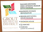

Sullivan Brothers Iowa Veterans Museum (2011) 
Rensselaer Russell House (1973) 
Snowden House (February 2011) See also: Grout MuseumEstablished in 1932, the district started with an endowment set up in the will of Henry W. Grout.[14] The district is a nonprofit educational entity that is active in engaging the students and all people from the surrounding communities. The district is accredited by the American Association of Museums.[15]
Grout Museum of History & Science
The first museum which would grow into the museum district was displayed for many years in the building that was the local YMCA. The current building was completed and opened to the public as a not for profit museum in 1956.[15]
Sullivan Brothers Iowa Veterans Museum
Opened in November 2008 at a cost of eleven million dollars funded in part by a grassroots campaign by average citizens.[15]
Rensselaer Russell House Museum
The Rensselaer Russell House, located at 520 W. 3rd Street in Waterloo, Iowa. Built in 1858, it is listed on the National Register of Historic Places. Rensselaer and Caroline Russell built the house utilizing Italianate architecture in 1861 for $5,878.83.[15]
Bluedorn Science Imaginarium
The Carl A. and Peggy J. Bluedorn Science Imaginarium opened in 1993 and provides both interactive exhibits and formal demonstrations in various fields of science.[15]
Snowden House
A two-story brick Victorian era house listed on the National Register of Historic Places was built in 1875. The house was once used as the Waterloo Woman's Club.[citation needed] The front lawn of the house was used for Michele Bachmann's Presidential candidacy announcement on June 27, 2011.[16]
Library
Waterloo has one central public library. For the fiscal year ending June 30, 2010, there were 274,903 patron visits resulted in circulation of 441,746 items. The total collection consisted of 168,295 items. The library’s reference services, supported by seven full-time-equivalent librarians, answered 70,000 questions. The library’s 43 public access computers provided over 108,430 sessions for patrons.[17]
The library is governed by a board of trustees, nominated by the city mayor and confirmed by the city council: Sue Smith, Jan Hahn, Troyce Vich, Karol Erdmann, and Alex Crouse.[18] The library is directed by Sheryl McGovern, MLS.[19]
The Waterloo Public Library is located in a renovated Great Depression era building that served as a post office and federal building. The building was renovated in the late 1970s for use as a library.[20] In 2011, the Waterloo Public Library celebrates 30 years at its current Commercial Street location.
Two New Deal-funded murals by artist Edgar Britton are on display at the library. "Exposition" is an image of the National Cattle Congress, and "Holiday" is of a picnic."[20]
Government
- See also: Waterloo Police Department
Waterloo is administered by the mayor and council system of government. One council member is elected from each of Waterloo's five wards, and two are elected at-large. The current mayor is Buck Clark, his predecessor was Timothy J. Hurley.
Education
Hawkeye Community College is located in Waterloo. Neighboring Cedar Falls is home to the University of Northern Iowa.
The three public high schools in the city are Waterloo West High School, Waterloo East High School, and Expo High School. West's school mascot is the "Wahawk", a contraction of Waterloo and Black Hawk (the city and county names), and its colors are old rose and black. Its most famous alumnus is former amateur wrestler and coach Dan Gable. Its current principal is Dr. Gail Moon.[21] East's school mascot is the "Trojan", a warrior from the ancient city Troy, and its colors are orange and black. Dr. Willie Barney is the current principal.[22] Expo is an alternative high school. Its current principal is Brenton Shavers.[23] Waterloo's only private high school is Columbus Catholic High School, which is supported by the Catholic parishes of Waterloo and Cedar Falls. Columbus' mascot is the "Sailor", a connection to the school's namesake Christopher Columbus, and its school colors are green and white. There is also a wide array of elementary and junior high schools in the area, with open enrollment available.
Media
Radio
-
- FM Stations
- 90.9 KUNI (FM)
- 92.3 KKHQ
- 94.5 KULT-LP
- 99.3 KWAY-FM
- 100.1 KBOL-LP
- 101.9 KNWS-FM
-
- AM Stations
Television
- 2 KGAN 2 (CBS) – Located in Cedar Rapids
- 7 KWWL 7 (NBC, This TV on DT2, RTN on DT3)- Located in Waterloo
- 9 KCRG 9 (ABC) – Located in Cedar Rapids
- 12 KIIN 12 (PBS/IPTV) – Located in Iowa City
- 17 K17ET 17 / K44FK 44 (TBN)
- 20 KWKB 20 (The CW/MNTV) – Located in Iowa City
- 22 KWWF 22 (Ind)
- 28 KFXA 28 (Fox) – Located in Cedar Rapids
- 32 KRIN 32 (PBS/IPTV)
- 40 KFXB 40 (CTN) – Located in Dubuque
- 48 KPXR 48 (Ion) – Located in Cedar Rapids
Print
- The Courier, daily newspaper
Infrastructure
Transportation
Waterloo is located at the north end of Interstate 380. U.S. Highways 20, 63, and 218 and Iowa Highway 21, also run through the metropolitan area. The Avenue of the Saints runs through Waterloo.
Delta Air Lines provides non-stop air service to and from Minneapolis/St. Paul from the Waterloo Regional Airport.
Waterloo is served by a metropolitan bus system (MET). MET serves most areas of Cedar Falls and Waterloo. Most routes meet at the central bus station in downtown Waterloo. The system operates Monday – Saturday. During the week the earliest bus is at 5:45 am from downtown Waterloo and the last bus arriving downtown at 6:40 pm. Service is more limited on Saturdays.
Waterloo is served by one daily intercity bus arrival and departure to Chicago and Des Moines. Service is provided by Burlington Trailways. New service to/from Mason City and Minneapolis/St. Paul provided by Jefferson Lines started in the Fall of 2009.[24]
There are currently four taxi operators in Waterloo and Cedar Falls. They are: First Call, Yellow, City Cab, and the newest is Cedar Valley Cab.
Utilities
The MidAmerican Energy Company supplies the Waterloo residents and businesses with electricity and natural gas. The Waterloo Water Works supplies potable water with a capacity of 50,400,000 GPD (gallons per day) with an average use of 13,400,000 GPD and a peak use of 28,800,000 GPD. Sanitation service (sewage) is operated by the city of Waterloo with a capacity of 36,500,000 GPD and an average use of 14,000,000 GPD.[25]
Healthcare
When considering the health care of the area one needs to think of Waterloo and Cedar Falls together as they share a long common border. As of November 2010[ref], Waterloo is home to two hospitals, Covenant Medical Center which has 366 beds and Allen Memorial Hospital with 234 beds. Cedar Falls is home to Sartori Memorial Hospital with 83 beds. The Waterloo/Cedar Falls metropolitan area has 295 physicians, 69 dentists, 52 chiropractors, 24 vision specialists and 21 nursing/retirement homes.[26]
Notable people
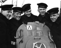 The Five Sullivan Brothers
- Julie Adams, actress in Creature from the Black Lagoon and other movies
- Michele Bachmann (born 1956) Minnesota Congresswoman [27]
- David Barrett, cornerback for New York Jets
- William Birenbaum (1923–2010), college administrator who served as president of Antioch College.[28]
- Horace Boies (1827–1923) governor of Iowa, 1890–1894[29]
- Bob Bowlsby, athletic director, Stanford University since 2006; University of Iowa, 1991–2005
- Allan Carpenter (born 1917) author of over 150 books[citation needed] relationship to Waterloo
- Don Denkinger, Major League Baseball umpire, made famous for "the call" in game 6 of 1985 World Series
- Rich Folkers, MLB player for New York Mets, St. Louis Cardinals, San Diego Padres, and Milwaukee Brewers
- Dan Gable, Olympic wrestling champion, multiple NCAA champion from Iowa State University, and distinguished collegiate coach
- John Wayne Gacy (1942–1994) serial killer [30]
- Kim Guadagno, First Lieutenant Governor of New Jersey[31][32]
- Lou Henry Hoover (1874–1944) wife of President Herbert Hoover and First Lady of the United States, 1929–1933.[33]
- MarTay Jenkins, (born 1975) NFL record holding wide receiver for Arizona Cardinals[34]
- Arthur R. Kelly (1878–1959) architect[citation needed] relationship to Waterloo
- Bonnie Koloc (born 1946) folk musician[citation needed] relationship to Waterloo
- John Hooker Leavitt, banker, state senator, son of Roger Hooker Leavitt[35]
- J.J. Moses (born 1979) NFL wide receiver for Arizona Cardinals[36]
- Larry Nemmers, NFL referee [37]
- Thunderbolt Patterson, professional wrestler
- Joe Pelton, poker player
- Don Perkins, running back for Dallas Cowboys
- Alfred C. Richmond, retired U.S. Coast Guard commandant
- Reggie Roby (1961–2005) punter for University of Iowa Hawkeyes and five NFL teams, 3 time Pro-Bowler[38]
- Zud Schammel (born 1910) NFL guard for the Green Bay Packers[39]
- Sean Schemmel, Voice actor
- Tracie Spencer, (born 1976) Winner of Star Search in 1987 as a singer, recorded music across many genres, acted and modeled[40]
- Darren Sproles, an American football running back for the San Diego Chargers of the National Football League.
- Suzanne Stephens (born 1946) clarinetist[41]
- The Sullivan Brothers, five sons who died together on the USS Juneau during World War II[42]
- Corey Taylor, Vocalist from Slipknot and Stonesour
- Mike van Arsdale, mixed martial artist, signed with the UFC
- Emily West (born 1981) country music singer/songwriter signed with Capitol Records [43]
- Nancy Youngblut, actress
See also
- Maytag-Mason Motor Company - An automobile manufacture in Waterloo.
References
- ^ "Find a County". National Association of Counties. http://www.naco.org/Counties/Pages/FindACounty.aspx. Retrieved 2011-06-07.
- ^ "Iowa's Largest Cities". Quad City Times. 2011-02-10. http://qctimes.com/article_c5d8850a-3556-11e0-ba3b-001cc4c002e0.html. Retrieved 2011-02-13.
- ^ The History of Black Hawk County. Chicago: Western Historical Company. 1878. pp. 383 (pdf-375). http://www.archive.org/details/cu31924028913832.
- ^ Clymer, Floyd. Treasury of Early American Automobiles, 1877–1925 (New York: Bonanza Books, 1950), p.93.
- ^ "City Profile". http://www.public.iastate.edu/~rfindlay/history.html.
- ^ "Cedar River at Waterloo". National Weather Service. http://water.weather.gov/ahps2/hydrograph.php?wfo=dmx&gage=aloi4&view=1,1,1,1,1,1,1,1. Retrieved 2011-08-04.
- ^ "City Data website". Waterloo-Iowa. http://www.city-data.com/city/Waterloo-Iowa.html. Retrieved November 24, 2010.
- ^ http://www.ustravelweather.com/weather-iowa/waterloo-weather.asp
- ^ U.S. Census Bureau. Census 2000. "Census Demographic Profiles, Waterloo, Iowa" (PDF). CenStats Databases. <http://censtats.census.gov/data/>. http://censtats.census.gov/data/IA/1601982425.pdf. Retrieved 2009-01-31.
- ^ U.S. Census Bureau. Census 2000. "QT-P1. Age Groups and Sex, Waterloo, Iowa". American FactFinder. <http://factfinder.census.gov>. http://factfinder.census.gov/servlet/QTTable?_bm=y&-geo_id=16000US1982425&-qr_name=DEC_2000_SF1_U_QTP1&-ds_name=D&-_lang=en&-redoLog=false. Retrieved 2009-01-31.
- ^ United States Census Bureau. "Cumulative Estimates of Population Change for Metropolitan Statistical Areas and Rankings: April 1, 2000 to July 1, 2008". http://www.census.gov/popest/metro/tables/2008/CBSA-EST2008-07.xls. Retrieved July 11, 2009.
- ^ a b c "Waterloo Center for the Arts/Directory". Waterloo Center for the Arts. http://www.waterloocenterforthearts.org/. Retrieved 2011-08-04.
- ^ "The History of Our Theatre in Waterloo". WCP & BHCT. http://www.wcpbhct.org/history.html. Retrieved 2011-08-04.
- ^ Eldridge, Mary Beth. "Brief Biographies of Early Residents of Waterloo, Black Hawk Co., Iowa". http://www.rootsweb.ancestry.com/~iabiog/blackhawk/h1993/h1993-al.htm. Retrieved 2011-06-30.
- ^ a b c d e "The Grout Museum District". homepage. http://www.groutmuseumdistrict.org/. Retrieved November 24, 2010.
- ^ Wiser, Mike (June 27, 2011). "Bachmann: "The voice that has been missing."". WCF COURIER.com. http://wcfcourier.com/iowacaucus/profiles/michele_bachmann/5618a2d8-a0bb-11e0-a58a-001cc4c002e0.html. Retrieved 2011-06-29.
- ^ Waterloo Public Library 2010 Annual Report
- ^ Waterloo Public Library Board of Trustees
- ^ About the Library Director – Waterloo Public Library
- ^ a b Waterloo Public Library History and Mission Statement
- ^ http://westhigh.waterloo.k12.ia.us/
- ^ http://easthigh.waterloo.k12.ia.us/
- ^ http://expo.waterloo.k12.ia.us/
- ^ "Jefferson Lines adds route to Waterloo, connects to eastern areas". Globe Gazette. June 19, 2009. http://www.globegazette.com/articles/2009/06/19/news/latest/doc4a3bcf6fe61a7543338425.txt#vmix_media_id=7011807. Retrieved October 31, 2009.
- ^ "Cedar Valley Alliance". Utilities. http://www.cvedc.com/utilities.htm. Retrieved November 30, 2010.
- ^ "Greater Cedar Valley Alliance". fact sheet 2009. http://www.cvedc.com/index_facts.html. Retrieved November 30, 2010.
- ^ Condon, Patrick (January 6, 2011). "Waterloo native Bachmann of Minnesota tests Iowa presidential waters". WCF Courier. http://wcfcourier.com/news/local/govt-and-politics/article_2d73fd9c-18f7-11e0-a882-001cc4c002e0.html. Retrieved 2011-05-01.
- ^ Fox, Margalit. "William M. Birenbaum, College Leader, Dies at 87", The New York Times, October 8, 2010. Accessed October 10, 2010
- ^ "National Governors Association". Horace Boies. http://www.nga.org/portal/site/nga/menuitem.29fab9fb4add37305ddcbeeb501010a0/?vgnextoid=7bfc224971c81010VgnVCM1000001a01010aRCRD&vgnextchannel=e449a0ca9e3f1010VgnVCM1000001a01010aRCRD. Retrieved 2010-12-02.
- ^ Lohr, David. "Boy Killer: John Wayne Gacy". Crime Magazine. http://www.crimemagazine.com/boy-killer-john-wayne-gacy. Retrieved 2011-06-27.
- ^ "State of New Jersey". Office of the Lieutenant Governor. http://www.state.nj.us/governor/lt/. Retrieved 2010-12-04.
- ^ "BALLOT*PEDIA". Kim Guadagno. http://www.ballotpedia.org/wiki/index.php/Kim_Guadagno. Retrieved 2010-12-04.
- ^ Allen, Anne Beiser (2000). An independent woman: the life of Lou Henry. Greenwood Press. pp. 5–9. ISBN 0-313-31466-7.
- ^ "National Football League". MarTay Jenkins. http://www.nfl.com/players/martayjenkins/profile?id=JEN397575. Retrieved 2010-12-07.
- ^ "John H. Leavitt, History of Waterloo, Waterloo Public Library". http://www.wplwloo.lib.ia.us/History/WlooBios/JohnHLeavitt.html.
- ^ "National Football League". J.J. Moses profile. http://www.nfl.com/players/j.j.moses/profile?id=MOS274967. Retrieved 2010-12-07.
- ^ Sulivan, Jim (December 30, 2007). "Official notice: Nemmers ready to hang up his whistle". WCF Courier. http://wcfcourier.com/sports/local/article_ad80f092-3fa7-5803-bec1-82a5fef5ed09.html. Retrieved 2011-03-17.
- ^ "Pro-Football-Reference". Reggie Roby bio. http://rbref.com/players/R/RobyRe20.htm. Retrieved 2010-12-07.
- ^ "PRO-FOOTBALL Reference". Zud Schammel. http://www.pro-football-reference.com/players/S/SchaZu20.htm. Retrieved 2010-12-17.
- ^ "DiVA station". Tracie Spencer bio.. http://www.divastation.com/tracie_spencer/spencer_bio.html. Retrieved 2010-12-06.
- ^ Suzanne Stephen biography on the Karlheinz Stockhausen website (Accessed July 10, 2010)
- ^ John R. Satterfield, We Band of Brothers: The Sullivans & World War II (Parkersburg, IA: Mid-Prairie Books, 1995). ISBN 0931209587
- ^ Bialas, Michael (May 18, 2010). "Finally on the Road, Emily West Keeps 'Em Laughing, Crying". The Huffington Post. http://www.huffingtonpost.com/michael-bialas/finally-on-the-road-emily_b_577968.html. Retrieved 2011-03-17.
External links
- City website
- Waterloo Convention and Visitors Bureau
- Community Foundation of Northeast Iowa
- City of Waterloo Brownfields Redevelopment Website
- City of Waterloo Economic Development Website
- Waterloo Public Library
- Waterloo Chamber of Commerce
- Waterloo Police Department
- Waterloo Community School District
- City Data Comprehensive statistical data and more about Waterloo, Iowa
- Historic
Coordinates: 42°29′33″N 92°20′46″W / 42.492436°N 92.346161°WMunicipalities and communities of Black Hawk County, Iowa County seat: WaterlooCities Cedar Falls | Dunkerton | Elk Run Heights | Evansdale | Gilbertville | Hudson | Janesville‡ | Jesup‡ | La Porte City | Raymond | Waterloo

Townships Barclay | Bennington | Big Creek | Black Hawk | Cedar | Cedar Falls | Eagle | East Waterloo | Fox | Lester | Lincoln | Mount Vernon | Orange | Poyner | Spring Creek | Union | Washington
Unincorporated
communitiesFootnotes ‡This populated place also has portions in an adjacent county or counties
Categories:- Cities in Iowa
- Populated places in Black Hawk County, Iowa
- Waterloo, Iowa
- County seats in Iowa
- Waterloo – Cedar Falls metropolitan area


Wikimedia Foundation. 2010.