- Derbyshire Dales
-
For the Parliamentary constituency, see Derbyshire Dales (UK Parliament constituency).
Derbyshire Dales District — District — Shown within Derbyshire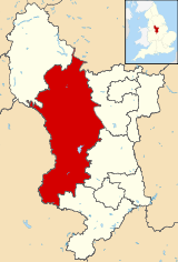
Sovereign state United Kingdom Constituent country England Region East Midlands Administrative county Derbyshire Founded Admin. HQ Matlock Government - Type Derbyshire Dales District Council - Leadership: Alternative - Sec.31 - Executive: Conservative - MP: Patrick McLoughlin Area - Total 305.9 sq mi (792.4 km2) Area rank 45th Population (2010 est.) - Total 70,400 - Rank Ranked 300th - Density 230.1/sq mi (88.8/km2) Time zone Greenwich Mean Time (UTC+0) - Summer (DST) British Summer Time (UTC+1) Postcode ISO 3166-2 ONS code 17UF OS grid reference NUTS 3 Ethnicity 97.8% White
0.8% .Asian[1]Website derbyshiredales.gov.uk Derbyshire Dales is a local government district in Derbyshire, England. Much of the district is situated in the Peak District, although most of its population lies along the River Derwent.
The borough borders the districts of High Peak, Amber Valley, North East Derbyshire and South Derbyshire in Derbyshire and also Sheffield in South Yorkshire.
The district offices are in Matlock. It was formed on 1 April 1974, originally under the name of West Derbyshire. The district adopted its current name in 1988. The district was a merger of Ashbourne, Bakewell, Matlock and Wirksworth urban districts along with Ashbourne Rural District and Bakewell Rural District.
Following their review of parliamentary representation in Derbyshire, the Boundary Commission for England has formed a new constituency called Derbyshire Dales.
Places
- Alsop-en-le-Dale, Ashford-in-the-Water, Ashbourne
- Bakewell, Baslow, Beeley, Biggin, Birchover, Bonsall, Bradbourne, Bradwell, Brassington, Bretton
- Calver, Carsington, Chatsworth, Chelmorton, Cromford, Curbar
- Darley Dale
- Earl Sterndale, Edensor, Elton, Eyam
- Fenny Bentley, Foolow, Froggatt
- Great Hucklow, Great Longstone, Grindleford
- Hassop, Hathersage, Hognaston, Hartington
- Kirk Ireton, Kniveton
- Little Hucklow, Litton
- Matlock, Matlock Bath, Middleton-by-Wirksworth, Middleton-by-Youlgreave, Monyash
- Over Haddon
- Parwich
- Rowsley
- Stanton-in-Peak, Stoney Middleton, Sudbury
- Taddington, Tansley, Thorpe, Tideswell, Tissington
- Wardlow, Wensley, Winster, Wirksworth
- Youlgreave
External links
References
Ceremonial county of Derbyshire Unitary authorities Boroughs or districts Amber Valley • Bolsover • Chesterfield • Derbyshire Dales • Erewash • High Peak • North East Derbyshire • South DerbyshireMajor settlements Alfreton • Ashbourne • Bakewell • Belper • Bolsover • Buxton • Chapel-en-le-Frith • Chesterfield • Clay Cross • Darley Dale • Derby • Dronfield • Eckington • Glossop • Hadfield • Heanor • Ilkeston • Killamarsh • Langley Mill • Long Eaton • Matlock • Melbourne • New Mills • Ripley • Sandiacre • Shirebrook • Staveley • Swadlincote • Whaley Bridge • Wirksworth
See also: List of civil parishes in DerbyshireRivers Topics High Sheriffs • Museums • Parliamentary constituenciesDerbyshire Amber Valley • Bolsover • Chesterfield • Derby • Derbyshire Dales • Erewash • High Peak • North East Derbyshire • South Derbyshire
Leicestershire Lincolnshire Nottinghamshire Ashfield • Bassetlaw • Broxtowe • Gedling • Mansfield • Newark and Sherwood • Nottingham • Rushcliffe
Northamptonshire Rutland Categories:- Local government in Derbyshire
- Derbyshire Dales
- Non-metropolitan districts of Derbyshire
- Local government districts of the East Midlands


Wikimedia Foundation. 2010.