- Culrain railway station
-
Culrain 
Cul Raoin 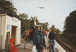
Culrain station with students who have stayed at Carbisdale Castle waiting for the train (1996) Location Place Culrain Local authority Highland Coordinates 57°55′08″N 4°24′14″W / 57.919°N 4.404°WCoordinates: 57°55′08″N 4°24′14″W / 57.919°N 4.404°W Operations Station code CUA Managed by First ScotRail Number of platforms 1 Live arrivals/departures and station information
from National Rail EnquiriesAnnual rail passenger usage 2004/05 * 2,016 2005/06 * 1,707 2006/07 * 1,771 2007/08 * 1,785 2008/09 * 2,274 History Original company Sutherland Railway Pre-grouping Highland Railway Post-grouping LMSR 1871[1] Opened National Rail - UK railway stations A B C D E F G H I J K L M N O P Q R S T U V W X Y Z * Annual passenger usage based on sales of tickets in stated financial year(s) which end or originate at Culrain from Office of Rail Regulation statistics. Please note: methodology may vary year on year.  Station nameboard now preserved at the Bredgar and Wormshill Light Railway
Culrain railway station serves the village of Culrain on the Kyle of Sutherland in the Highland council area of Scotland. It is located on the Far North Line. The railway line through Culrain is single track, with the nearest passing loop to the north being at Lairg and to the south at Ardgay.
The station is close to Carbisdale Castle, now operating as a youth hostel owned by the Scottish Youth Hostels Association. Many passengers using Culrain station are visitors staying at the hostel.
Contents
History
Services
Timetable changes in December 2008 increased the number of trains through Culrain. On Mondays to Saturdays, there are four trains a day southbound to Inverness and three a day northbound to Wick. On Sundays there is one train in each direction.
Preceding station  National Rail
Following station Ardgay First ScotRail
Far North LineInvershin Historical railways Ardgay Highland Railway
Invershin References
Sources
- Butt, R. V. J. (1995). The Directory of Railway Stations: details every public and private passenger station, halt, platform and stopping place, past and present (1st ed.). Sparkford: Patrick Stephens Ltd. ISBN 1-8526-0508-1. OCLC 60251199.
- Jowett, Alan (March 1989). Jowett's Railway Atlas of Great Britain and Ireland: From Pre-Grouping to the Present Day (1st ed.). Sparkford: Patrick Stephens Ltd. ISBN 1-8526-0086-1. OCLC 22311137.
- RAILSCOT on Sutherland Railway
Categories:- Railway stations in Highland (council area)
- Railway stations served by First ScotRail
- Railway stations opened in 1871
- Former Highland Railway stations
- Scotland railway station stubs


Wikimedia Foundation. 2010.