Roy Bridge railway station

Roy Bridge railway station
Roy Bridge National Rail
Drochaid Ruaidh
Roy Bridge
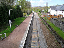
Location
Place Roybridge
Local authority Highland
Coordinates 56°53′17″N 4°50′13″W / 56.888°N 4.837°W / 56.888; -4.837Coordinates: 56°53′17″N 4°50′13″W / 56.888°N 4.837°W / 56.888; -4.837
Operations
Station code RYB
Managed by First ScotRail
Number of platforms 1
Live arrivals/departures and station information
from National Rail Enquiries
Annual rail passenger usage
2004/05 * 3,344
2005/06 * 3,370
2006/07 * 3,812
2007/08 * 4,301
National Rail - UK railway stations
A B C D E F G H I J K L M N O P Q R S T U V W X Y Z
* Annual passenger usage based on sales of tickets in stated financial year(s) which end or originate at Roy Bridge from Office of Rail Regulation statistics. Please note: methodology may vary year on year.
Portal icon UK Railways portal

Roy Bridge railway station is a railway station serving the village of Roybridge in the Highland region of Scotland. This station is on the West Highland Line.

The station was originally a two platform station, the up loop being removed in 1966. The main station buildings and signal box were both located on the up side and were demolished after closure and de-manning.

External links

Preceding station National Rail National Rail Following station
Tulloch   First ScotRail
West Highland Line
  Spean Bridge
Tulloch   First ScotRail
Highland Caledonian Sleeper
Request stop
  Spean Bridge


Wikimedia Foundation. 2010.

Игры ⚽ Нужно сделать НИР?

Look at other dictionaries:

  • Spean Bridge railway station — Spean Bridge Drochaid an Aonachain The for …   Wikipedia

  • Tulloch railway station — Infobox UK station name = Tulloch other name= An Tulach code = TUL caption = Photo taken from nearby Dun Dearg showing the West Highland Line as it passes through Tulloch manager = First ScotRail locale = Tulloch borough = Highland start =… …   Wikipedia

  • Stafford railway station — Infobox UK station name = Stafford manager = Virgin Trains locale = Stafford borough = Stafford latitude = 52.80359 longitude = 2.12307 code = STA start = July 1837 Rebuilt 1844 Rebuilt 1862 Current building opened 1962 platforms = 5 usage0405 =… …   Wikipedia

  • Glen Roy — in the Lochaber area of the Highlands of Scotland is a National Nature Reserve and is noted for the geological puzzle of the three roads ( Parallel Roads ), which are preserved ice dammed lake shorelines, from a brief (some 900 1,100 years in… …   Wikipedia

  • Bridge — This article is about the structure. For other uses, see Bridge (disambiguation). The Akashi Kaikyō Bridge in Japan, the world s longest suspension span …   Wikipedia

  • Jezreel Valley railway — The Jezreel Valley railway, or simply the Valley railway ( he. רכבת העמק, Rakevet HaEmek ) refers to a historical railroad in Ottoman and British Palestine, which was part of the larger Hejaz railway and ran along the Jezreel Valley.It was built… …   Wikipedia

  • Mid-Norfolk Railway — Steam hauled train on Danemoor Bank, 2011 Locale England Terminus Dereham Connections Breckland Line: near Wymondham …   Wikipedia

  • Dunblane, Doune and Callander Railway — [v · d · …   Wikipedia

  • Lochearnhead, St Fillans and Comrie Railway — [v · d · …   Wikipedia

  • Callander and Oban Railway — The Callander and Oban Railway company was formed in 1864 with the objective of linking Callander, Scotland to the west coast port of Oban over challenging terrain, particularly at Glen Ogle and the Pass of Brander at Loch Awe. Callander had been …   Wikipedia

Share the article and excerpts

Direct link
Do a right-click on the link above
and select “Copy Link”