- Chittering, Cambridgeshire
-
Coordinates: 52°18′27″N 0°11′43″E / 52.30759°N 0.19519°E
Chittering 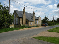
The Old Schoolhouse, Chittering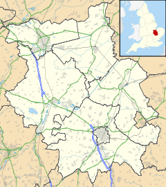
 Chittering
Chittering shown within CambridgeshirePopulation 120 OS grid reference TL496700 District South Cambridgeshire Shire county Cambridgeshire Region East Country England Sovereign state United Kingdom Post town CAMBRIDGE Postcode district CB25 Dialling code 01223 Police Cambridgeshire Fire Cambridgeshire Ambulance East of England EU Parliament East of England UK Parliament South East Cambridgeshire List of places: UK • England • Cambridgeshire Chittering is a hamlet about 8 miles (13 km) north of Cambridge in Cambridgeshire, England. For administrative purposes it is part of the parish of Waterbeach.
The village lies on the Ely Road (A10) between Waterbeach and Stretham. It has one pub, The Traveller's Rest.
Contents
History
Situated towards the southern end of The Fens, the marshes in the Chittering area were first settled in Roman times. Investigations around Causeway End Farm in Chittering Fen show evidence of dwellings and inclosed fields that were occupied from the early 2nd to the early 4th century. Denny Abbey, just to the south of the hamlet, was built in around 1150. [1]
The fenland around Chittering has been known as North Fen since at least the 14th century. Over the following centuries it was gradually divided into smaller areas, and Chittering Fen – so named by the early 15th century – covered an area of around 700 acres (280 ha) by the 19th century and was principally used for growing hay.[1]
A school was built in the village to accommodate 54 children in 1877, but numbers had declined to only 19 by the start of the Second World War. The school closed in 1969.[1]
The former micro-brewery, the City of Cambridge Brewery (originally located in Cheddars Lane, Cambridge), used a reedbed system to deal with its waste water, but brewing ceased on the site in 2007 and the remaining assets were sold off in 2011. [2]. There was a second pub in the area, the Plough and Horses, which was open from the 19th century until around 1900.[1]
References
- ^ a b c d A History of the County of Cambridge and the Isle of Ely. 9. 1989. pp. 237-243. http://www.british-history.ac.uk/report.aspx?compid=15423.
- ^ "Brewery History". City of Cambridge Brewery. http://www.cambridge-brewery.co.uk/brewery-history/brewery-history.html. Retrieved 2010-02-25.
See also
External links
 Media related to Chittering, Cambridgeshire at Wikimedia CommonsCategories:
- Villages in Cambridgeshire


Wikimedia Foundation. 2010.