- Peak Cavern
-
Peak Cavern 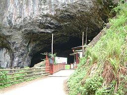
Peak Cavern entranceLocation Castleton, Derbyshire Geology Limestone The Peak Cavern, also known as the Devil's Arse (called so because of the flatulent-sounding noises from inside the cave), is one of the four show caves in Castleton, Derbyshire, England. Peakshole Water flows through and out of the cave.
Contents
Overview
 A plan of the Peak Cavern from 1834.
Unlike the other show caves in the area, Peak Cavern is almost entirely natural; the only artificial part of the cave was blasted to bypass a low tunnel that was only accessible by lying down on a boat. The cave system is the largest in the Peak District, and the main entrance is the largest cave entrance in Britain. Until 1915 the cave was home to some of Britain's last troglodytes (the cave-houses at Kinver Edge near Kidderminster were populated until the 1950s), who lived in houses built inside the cave mouth, and made a living from rope making, while the depths of the cave were known as a haven for bandits.[citation needed] It was supposed to be the place where thieves' cant was created by a meeting between Cock Lorel, leader of the rogues and the King of the Gypsies.[citation needed]
Several passages lead from the entrance, known as "The Vestibule". The only one open to the public is "Lumbago Walk", named as traversing it requires most adults to stoop. The route continues through two main caverns, "The Great Cave" and "Roger Rain's House", and into a passage, "Pluto's Dining Room". This is the furthest point currently open to the public, but the show cave used to extend considerably further: down "The Devil's Staircase" to "The Halfway House" and then along an underground stream known as the "Inner Styx", via a series of bridges and under "Five Arches".[1]
At this point, several routes are open to cavers. The main path, to the right, leads to "Victoria Aven", a sizeable shaft and on to "Far Sump", through which lies the Far Sump Extension. This area was first explored in 1980, but difficult access limited discoveries until routes through from Speedwell Cavern and James Hall's Over Engine Mine were opened in 1996.[1] This permitted further exploration, and in 1999 Titan Shaft was discovered, at 141.5 metres (464 ft) the deepest pitch in Britain.
The name
The name of the cave was changed in 1880 from "Devil's Arse" to "Peak Cavern" in order not to cause offence to Queen Victoria during a visit for a concert. More recently the cave has been promoted using its older, more vulgar name.[2]
See also
- Neil Moss — famous caving accident in Peak Cavern
- The Devil's Point, Cairngorms, Scotland — also renamed to spare Queen Victoria embarrassment.
References
- ^ a b Peak Cavern Description
- ^ Richard Hawley (2006-08-05). "Richard Hawley in Yorkshire and Derbyshire". The Guardian. http://www.guardian.co.uk/theguardian/2006/aug/05/weekend7.weekend. Retrieved 2008-06-24.
External links
- For an interesting description of an excursion taken on 29 June 1827, see William Hone's Table-book.[1]
- Peak Cavern official website (also marketed as the Devil's Arse)
Categories:- Caves of Derbyshire
- Show caves in the United Kingdom
- Visitor attractions in Derbyshire
- Visitor attractions of the Peak District


Wikimedia Foundation. 2010.