- Porto Velho
Infobox City
name = Porto Velho
settlement_type = Municipality
official_name = The Municipality of Porto Velho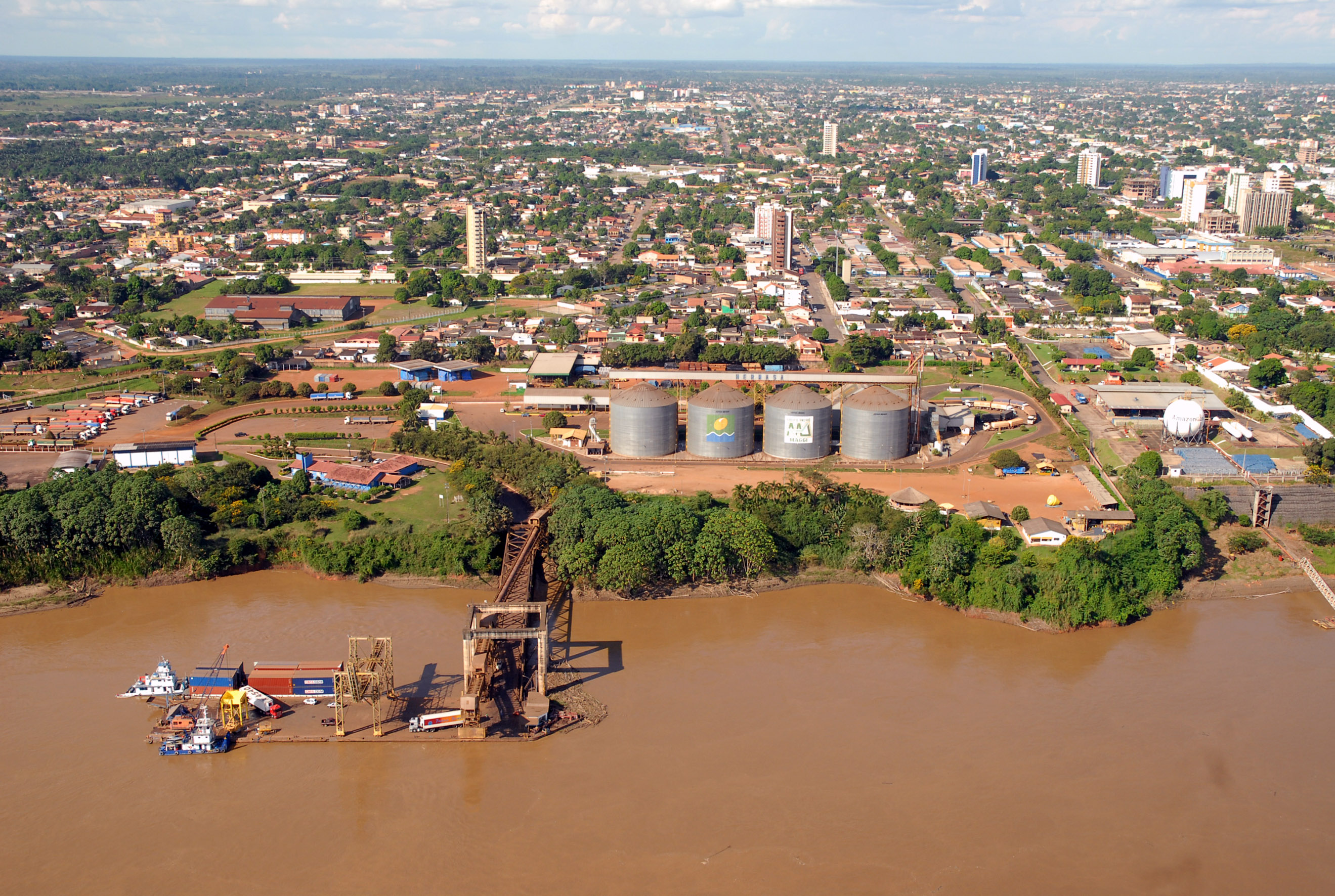
imagesize = 250px
image_caption = Porto Velho and the Madeira River
image_

mapsize = 250px
map_caption = Location of Porto Velho in the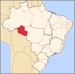
subdivision_type = Country
subdivision_type1 = Region
subdivision_type2 = State
subdivision_name = flag|Brazil
subdivision_name1 = North
subdivision_name2 =
leader_title =Mayor
leader_name = Roberto Sobrinho (PT)
area_note =
area_total_km2 = 34082
population_as_of = 2005
population_total = 373,917
population_density_km2 = 10.9
population_total = 373917
population_footnotes = [http://www.citymayors.com/gratis/brazilian_cities.html]
timezone = UTC-4
utc_offset = -4
timezone_DST =
utc_offset_DST =
latd=8 |latm=45 |lats=43 |latNS=S |longd=63 |longm=54 |longs=14 |longEW=W
elevation_ft =
blank_name = HDI (2000)
blank_info = 0.763 – medium
website = [http://www.portovelho.ro.gov.br Porto Velho, Rondônia]
footnotes =Pôrto Velho is the
capital of theBrazil ianstate ofRondônia , in the upperAmazon River basin. The population is about 334,661 people. Located at theborder of Rondônia and the state of Amazonas, the town is an important trade center ofcassiterite , the mining of which represents the most important economic activity in theregion , and a transportation and communication center. It is located on the eastern shore of theMadeira River , one of the main tributaries of theAmazon River . Officially founded onOctober 2 1914 , Porto Velho was started by pioneers around 1907, during the construction of the Madeira-Mamoré Railroad. After therailroad was completed, the local population was about one thousand inhabitants; its buildings were chiefly the railway's installations and the wooden houses of theCaribbean workers - hence the name of the town's largest district by then, "Barbadoes Town", nowadays called the "Alto do Bode". During the first sixty years, the city's development was directly connected to the railway's activities. The town prospered during therubber boom, but then when low-costMalaysia n rubber made rubber from the Amazon uncompetitive, the region's economy ground to a halt. Cities like Santo Antônio do Madeira, which had atram line and a weeklynewspaper by the time of Porto Velho's foundation, are nothing but ruins nowadays. Porto Velho's survival is associated with the better conditions of the area where it was built, its easy access by the river, its harbor: these were all considerations in the choice of Porto Velho as the capital of the newly-formed Federal Territory ofGuaporé , in 1943. Only with the beginning ofWorld War II there was another cycle of progress in the region. When theAllied forces lost control over the Malaysian rubber, Amazon's was needed due to thewar effort . This produced what is know in Brazil as the "secondrubber boom ". But when the war ended, the region's economy once again came to a halt. Porto Velho's modernhistory begins with the discovery of cassiterite around the city, and ofgold on the Madeira River, by the end of the fifties. Also, the government's decision to allow large cattle farms in the territory began a trend of migration into the city. Almost one million people moved to Rondônia, and Porto Velho's population increased to three hundred thousand. This intense migration caused much trouble for the city. For example, the suburban boroughs are nothing butshanty town s, among many other problems.Geography
Climate
An
equatorial climate is a type oftropical climate in which there is nodry season – all months have meanprecipitation values of at least 60mm. It is usually found atlatitude s within five degrees of theequator – which are dominated by theIntertropical Convergence Zone . The equatorial climate is denoted "Af" in theKöppen climate classification .Tropical rainforest is the natural vegetation in equatorial regions.Vegetation
The Amazon represents over half of the planet's remaining
rainforest s and comprises the largest and most species-rich tract oftropical rainforest in theworld . Wet tropical forests are the most species-richbiome , and tropical forests in theAmericas are consistently more species rich than the wet forests inAfrica andAsia .Turner, I.M. 2001. "The ecology of trees in the tropical rain forest".Cambridge University Press , Cambridge. ISBN 0-521-80183-4] As the largest tract of tropical rainforest in the Americas, the Amazonian rainforests have unparalleledbiodiversity .More than 1/3 of all species in the world live in the Amazon Rainforest. [ [http://www.worldwildlife.org/wildplaces/amazon/index.cfm Amazon Rainforest, Amazon Plants, Amazon River Animals] ]
Economy
The
GDP for the city was R$ 3,656,512,000 (2005). [cite book|url=http://www.ibge.gov.br/home/estatistica/economia/pibmunicipios/2005/tab01.pdf|title=GDP|publisher=IBGE |location=Porto Velho, Brazil|format=PDF|isbn=85-240-3919-1|accessdate=2007-07-18|year=2005|language=Portuguese]The
per capita income for the city was R$ 9,779 (2005). [cite book|url=http://www.ibge.gov.br/home/estatistica/economia/pibmunicipios/2005/tab01.pdf|title=per capita income|publisher=IBGE |location=Porto Velho, Brazil|format=PDF|isbn=85-240-3919-1|accessdate=2007-07-18|year=2005|language=Portuguese]Education
Portuguese is the official national language, and thus the primary language taught in schools. But English and Spanish are part of the official
high school curriculum.Educational institutions
* Universidade Federal de Rondônia (Unir);
* Escola Agrotécnica Federal de Colorado do Oeste (EAFCO);
* Instituto Luterano de Ensino Superior de Porto Velho (Iles-Ulbra);
* Faculdade de Ciências Administrativas e de Tecnologia (Fatec-RO);
* Faculdade de Ciências Biomédicas de Cacoal (Facimed);
* Faculdade de Ciências Humanas, Exatas e Letras de Rondônia (Faro);
* Faculdade da Amazônia (Iesa);
* and many others.Culture
Expovel
Agricultural event in Porto Velho.
Museum
Museum of Estrada de Ferro Madeira-Mamoré.
Theatre
Teatro Municipal, in Joaquim Nabuco
Avenue (Downtown ) and Teatro Uirassu Rodrigues, in José Bonifáciostreet .Infrastructure
International Airport
Porto Velho International Airport, located seven kilometers from the city, has as its main access Av. Governador Jorge Teixeira de Oliveira, with two lanes. The average commute is ten minutes. Buses from downtown run to the airport every hour, and there is a fleet of taxis serving only the airport. The airport is served by 98 scheduled flights weekly, most going to other large Brazilian cities. Scheduled regional routes go to the municipalities of Costa Marques (RO), Lábrea (AM), Manicoré (AM), Cacoal (RO), Jí-Paraná (RO), Vilhena (RO) and Novo Aripuanã (RO). The scheduled airlines flying out of Porto Velho Airport are Vasp, Varig, TAM, Tavaj Rico and Cruiser, besides air taxi firms – Especial, Eucatur, Assis Aéreo Táxi, Tropical Táxi Aéreo, Rima Táxi and Aeronorte. There are also small aircraft owned by private individuals and public institutions (Rondônia state government). The presence of Porto Velho Air Base ensures considerable movement of military aircraft. The local people refer to Porto Velho International as Belmont Airport because it is located in this district. It became an international airport in 2002. It is located 88 meters (2.90 feet), at 084249 South latitude and 0635410 West longitude.
Highways
*BR-174;
*BR-317;
*BR-319;
*BR-364;
*BR-364;
*BR-421;
*BR-425;
*BR-429;
*RO-010;
*RO-101;
*RO-490.References
External links


Wikimedia Foundation. 2010.