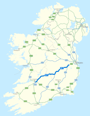
- N7 road (Ireland)
-
N7 road
Route information Part of 
Length: 205 km (127 mi) Location Primary
destinations:(bypassed routes in italics)
Road network The N7 road is a national primary road in Ireland, connecting Limerick and Dublin. The majority of the route (between Naas and Limerick) is motorway standard and is designated as the M7 motorway. At the Rosbrien interchange in Limerick the route continues as the N18 dual carriage/motorway to Shannon and Ennis. The road passes through the midlands of Ireland, and acts as a trunk route out of Dublin for the N8/M8 and N9/M9 roads to Cork and Waterford respectively. It forms part of European route E20.
Contents
Route
N7 - Naas Road
 Naas Road section of the N7 after upgrading.
From the M50, the N7 passes south of Clondalkin leaving the city as part of the Naas Road. (The Naas Road begins at the Grand Canal as a regional road (R810), a continuation of the Tyrconnell Road. It continues 3.4 km southwest to the M50 motorway, at the Red Cow interchange, where it becomes the N7.) A 15 km (9.3 mi) section of the N7 south of the M50 junction was upgraded to three lanes of dual-carriageway (i.e. an extra lane on each side), with work having commenced on the 4 January 2005 and concluded on 14 August 2006 (thumbnail left); having been originally dualled between 1963 and 1968. This section of the N7 bypasses Kill and Johnstown in County Kildare. As part of the upgrade, grade-separated interchanges were constructed. The old junctions consisted of traffic lights with a break in the dual-carriageway median. The three lane section ends at junction 9 (Naas, Sallins) with a left hand lane-drop/lane-gain for traffic leaving/entering here. The section of the N7 between Naas and Dublin is the second busiest road in the country.
This part of the route is the only section that remains designated as N7 as the road is not motorway standard. Left-in/left-out access is provided to minor roads and to homes, farms and businesses along this section.
New signage erected as part of this scheme includes junction numbers (previously the only numbered N7 junctions were some of the interchanges on the M7 motorway).
M7 - Naas to Limerick
M7 motorway

 Clickable image
Route information Part of 

Length: 112 km (70 mi)
Planned length: 185 km (115 mi)History: Opened in 1983 (Naas bypass, J7-J8)
1993 (Newbridge Bypass, J8-J10)
1997 (Portlaoise bypass)
2003 (Kildare bypass)
2004 (Monasterevin bypass)
2004 (Limerick Southern Ring Road - Phase I)
2010 (Nenagh to Limerick), (Portlaoise to Borris-in-Ossory), (Castletown to Nenagh)Major junctions From: (N7 from Dublin) Naas 


To: Rosbrien Interchange Limerick Location Primary
destinations:Newbridge, Monasterevin, Portlaoise (M8 to Cork), Roscrea, Nenagh Road network  N7 Junction 13 westbound on the M7 near Kildare.Main article: M7 motorway (Ireland)
From Naas motorway restrictions are enforced and the route is designated as the M7 motorway. The route continues in a south west direction bypassing the towns of Naas, Newbridge, Kildare, Monasterevin and Portlaoise. The M9 to Waterford diverges from the route at junction 11. South of Portlaoise the M8 diverges from the M7 to Cork and the south at junction 19 with the M7 continuing south westwards bypassing the towns of Mountrath, Borris-in-Ossory, Castletown (Co. Laois), Roscrea, Moneygall, Toomevara, Nenagh and Birdhill. From Birdhill the route continues towards Limerick city where it forms part of the Limerick Southern Ring Road bypassing Annacotty and Castletroy. The route terminates at the Rosbrien Interchange to the south of Limerick City. The road continues as the N18 into county Clare.
M7 - Limerick Southern Ring Road
 N7 Limerick Southern Ring Phase 1 - J29
The N7 route officially follows the Southern Ring Road (also upgraded to motorway status) around Limerick City to meet the M20 and the N18. The Southern Ring Road continues as the N18. As of 2006[update], most signage in Limerick City has not been upgraded to reflect this, and the R445 (old N7 route through the city) [1] is mostly still signposted as the N7. The R445 is properly signposted from the N7 at the beginning of the Southern Ring Road.
Construction on this project was divided into 2 phases; Phase 1 and Phase 2. Phase 1 of the scheme consists of approximately 10 km (6.2 mi) of dual carriageway, and was completed in May 2004, and joins the N20 road to Cork and the N21 road to Kerry. Two grade separated junctions allow access to Limerick city at Annacotty via the R445 and at Ballysimon via the N24. The N20 Carew park link road was closed permanently to inbound traffic from both the M7 and M20 in June 2010 to facilitate phase 2 of the Limerick southern ring road project.
Construction started on Phase 2 of the scheme on 26 October 2006, when the then Minister for Transport, Martin Cullen, turned the sod on the project. Phase 2 consists of 10 km (6.2 mi) of dual carriageway, 11 bridges, 6 underpasses, 4 interchanges and 900m (½ mile) of tunnel under the River Shannon. The scheme links up to the N18 Ennis Road. The project was completed and opened to traffic on the 27 July 2010 – 2 months ahead of schedule. The scheme opened as part of the N18 Galway to Limerick route meaning that the N7/M7 Dublin to Limerick route, the M20/N20 Limerick to Cork route and the M18/N18 Galway to Limerick route terminate at the same junction at Rosbrien. 2 new interchanges were built at the Dock road and Clonmacken to allow access to the city. It road is tolled.
The tunnel project is a PPP (Public Private Partnership), and will cost roughly €660m. The cost to the actual government will be around €360m.
History
Originally the N7 was a single carriage-way route between Dublin and Limerick and passed through the main towns on the route that are now bypassed. The old N7 route now bypassed by the M7 is currently designated as the R445 and is an alternative route between Limerick and Dublin.
The N7 is the only one of the inter-urban routes out of Dublin which does not commence in Dublin city centre, but rather at the M50. The original N7 route (under the Local Government (Roads and Motorways) Act, 1974 (Decleration of National Roads) Order, 1977) started the route in Dublin city centre, like the other national routes, with the route originally running through Inchicore village before reaching the Naas Road. However in 1994, following the construction of the Chapelizod bypass which brought the N4 road in to Dublin city centre as dual carriageway, the N7 inside the M50 was downgraded to regional road status (as the R110 road), with N7 traffic being signposted to use the N4 and M50 rather than the original route through Inchicore.
The N7 is noted for two firsts in the history of Irish roads - the first substantial length of dual carriageway in the Republic of Ireland, running 26 km (16 mi) from Dublin to Naas which was completed in 1968 and also the Republic of Ireland's first section of motorway, the 8 km (5.0 mi) Naas Bypass, opened in 1983 bypassing the original route through the town.
The old N7 route (now R445/R110) also formed most of the T5 trunk route between Dublin and Limerick. This was an old method of designating routes in Ireland before the current method was introduced.
Map of Route
Junctions
The junctions on the Naas Bypass and Newbridge Bypass sections of the M7 were previously numbered J7-J11 (now renumbered Junctions 9-13), in the expectation that an M7 motorway would be built along a new alignment. Instead the Naas Road dual-carriageway was upgraded. The R113 junction (Newlands Cross) is (2008) the only remaining at-grade junction between the M50 and M7, with traffic lights and a break in central median. There are plans to construct a grade separated interchange here. [1] There also remain some private accesses and minor exits prior to J9, the beginning of the M7 motorway.
Junction 13 westbound on the M7 near Kildare. Raised section of the Kildare bypass.
 The M7 leg of the M7/M8 PPP scheme under construction east of Borris-in-Ossory, 22 May 2010.
 The M7/M8 interchange at M7 junction 19 just days before the scheme opened to traffic on 28 May 2010.
 The M7 Castletown-Nenagh Scheme under construction east of Dunkerrin, 22 May 2010.
N7 dual carriageway Eastbound Junction Westbound M50 motorway 

M50 motorway Newlands Cross (at grade); Belgard Road for Tallaght;
Fonthill Road for Clondalkin (R113)— Newlands Cross (at grade); Belgard Road for Tallaght;
Fonthill Road for Clondalkin (R113)Kingswood Interchange: Outer Ring Road (R136) 
Kingswood Interchange: Outer Ring Road (R136) Citywest Road (N82) 
Citywest Road (N82) Rathcoole 
Rathcoole Steelstown Interchange: Steelstown 
Steelstown Interchange: Steelstown Castlewarden Interchange: Castlewarden (R445) 
Castlewarden Interchange: Castlewarden (R445) Kill Interchange: Kill (R445) 
Kill Interchange: Kill (R445) Johnstown Interchange: Johnstown (R445) 
Johnstown Interchange: Johnstown (R445) M7 motorway Eastbound Junction Westbound Maudlins Interchange: Naas North, Sallins (R445) 
Maudlins Interchange: Naas North, Sallins (R445) Naas South, Caragh and Togher services 
Naas South, Caragh and Togher services No access The SOUTH EAST (M9  )
)
The Curragh, Newbridge (R445) 
The Curragh Kildare, Nurney (R415) 
Kildare Nurney (R415) Monasterevin (R445) 
Monasterevin (R445) Portarlington, Emo, The Heath (R423) 
Portarlington, Emo, The Heath (R423) Portlaoise (R445) (Carlow, Tullamore, N80) Portlaoise (R445) (Carlow, Tullamore, N80) Abbeyleix (N77); Portlaoise (R423) Abbeyleix (N77); Portlaoise (R423) Portlaoise (R445) 
Mountrath, Castletown, Tullamore (R445) 
No access The SOUTH (M8 ) - Cork, Cashel, FermoyBorris-in-Ossory 
Borris-in-Ossory Roscrea Templemore (N62) Roscrea Templemore (N62) Moneygall 
Moneygall Toomevara, Nenagh (R445) 
Toomevara, Nenagh (R445) Knockalton, Nenagh, Thurles (R498) 
Knockalton, Nenagh, Thurles (R498) Carrigatoher, Nenagh (R445), (N52) Carrigatoher, Nenagh (R445), (N52) Birdhill, Killaloe, Ballina (R494)[2] 
Birdhill, Killaloe, Ballina (R494) Annacotty, Limerick (east) (R445), Newport (R503) 
Annacotty, Limerick (east) (R445), Newport (R503) Ballysimon Interchange, Limerick (centre) (R527), Waterford (N24) Ballysimon Interchange, Limerick (centre) (R527), Waterford (N24) Rossbrien Interchange, Limerick (city centre) (R509), Cork (M20 )Rossbrien Interchange, Cork (M20 )Continues as N18 dual carriageway. See also
- Roads in Ireland
- Motorways in Ireland
- National secondary road
- Regional road
References
- ^ Roads Act 1993 (Classification of Regional Roads) Order 2006 – Department of Transport
- ^ Hayden, James. "Section of M7 Nenagh-Limerick motorway opens - Tipperary Today". Tipperarystar.ie. http://www.tipperarystar.ie/news/Section-of-M7-NenaghLimerick-motorway.6209695.jp. Retrieved 2010-06-01.
Roads in Ireland Motorways National primary roads National secondary roads Regional roads (R101–R399) R101 · R102 · R103 · R104 · R105 · R106 · R107 · R108 · R109 · R110 · R111 · R112 · R113 · R114 · R115 · R116 · R117 · R118 · R119 · R120 · R121 · R122 · R123 · R124 · R125 · R126 · R127 · R128 · R129 · R130 · R131 · R132 · R133 · R134 · R135 · R136 · R148 · R149 · R150 · R151 · R152 · R153 · R154 · R155 · R156 · R157 · R158 · R159 · R160 · R161 · R162 · R163 · R164 · R165 · R166 · R167 · R168 · R169 · R170 · R171 · R172 · R173 · R174 · R175 · R176 · R177 · R178 · R179 · R180 · R181 · R182 · R183 · R184 · R185 · R186 · R187 · R188 · R189 · R190 · R191 · R192 · R193 · R194 · R195 · R196 · R197 · R198 · R199 · R200 · R201 · R202 · R203 · R204 · R205 · R206 · R207 · R208 · R209 · R210 · R211 · R212 · R213 · R214 · R229 · R230 · R231 · R232 · R233 · R234 · R235 · R236 · R237 · R238 · R239 · R240 · R241 · R242 · R243 · R244 · R245 · R246 · R247 · R248 · R249 · R250 · R251 · R252 · R253 · R254 · R255 · R256 · R257 · R258 · R259 · R260 · R261 · R262 · R263 · R264 · R265 · R266 · R267 · R268 · R277 · R278 · R279 · R280 · R281 · R282 · R283 · R284 · R285 · R286 · R287 · R288 · R289 · R290 · R291 · R292 · R293 · R294 · R295 · R296 · R297 · R298 · R299 · R310 · R311 · R312 · R313 · R314 · R315 · R316 · R317 · R318 · R319 · R320 · R321 · R322 · R323 · R324 · R325 · R326 · R327 · R328 · R329 · R330 · R331 · R332 · R333 · R334 · R335 · R336 · R337 · R338 · R339 · R340 · R341 · R342 · R343 · R344 · R345 · R346 · R347 · R348 · R349 · R350 · R351 · R352 · R353 · R355 · R356 · R357 · R358 · R359 · R360 · R361 · R362 · R363 · R364 · R365 · R366 · R367 · R368 · R369 · R370 · R371 · R372 · R373 · R374 · R375 · R376 · R377 · R378 · R379 · R389 · R390 · R391 · R392 · R393 · R394 · R395 · R396 · R397 · R398 · R399Regional roads (R400–R699) R400 · R401 · R402 · R403 · R404 · R405 · R406 · R407 · R408 · R409 · R410 · R411 · R412 · R413 · R414 · R415 · R416 · R417 · R418 · R419 · R420 · R421 · R422 · R423 · R424 · R425 · R426 · R427 · R428 · R429 · R430 · R431 · R432 · R433 · R434 · R435 · R436 · R437 · R438 · R439 · R440 · R441 · R442 · R443 · R444 · R445 · R446 · R448 · R449 · R458 · R459 · R460 · R461 · R462 · R463 · R464 · R465 · R466 · R467 · R468 · R469 · R470 · R471 · R472 · R473 · R474 · R475 · R476 · R477 · R478 · R479 · R480 · R481 · R482 · R483 · R484 · R485 · R486 · R487 · R488 · R489 · R490 · R491 · R492 · R493 · R494 · R495 · R496 · R497 · R498 · R499 · R500 · R501 · R502 · R503 · R504 · R505 · R506 · R507 · R509 · R510 · R511 · R512 · R513 · R514 · R515 · R516 · R517 · R518 · R519 · R520 · R521 · R522 · R523 · R524 · R525 · R526 · R527 · R548 · R549 · R550 · R551 · R552 · R553 · R554 · R555 · R556 · R557 · R558 · R559 · R560 · R561 · R563 · R564 · R565 · R566 · R567 · R568 · R569 · R570 · R571 · R572 · R573 · R574 · R575 · R576 · R577 · R578 · R579 · R580 · R581 · R582 · R583 · R584 · R585 · R586 · R587 · R588 · R589 · R590 · R591 · R592 · R593 · R594 · R595 · R596 · R597 · R598 · R599 · R600 · R601 · R602 · R603 · R604 · R605 · R606 · R607 · R608 · R609 · R610 · R611 · R612 · R613 · R614 · R615 · R616 · R617 · R618 · R619 · R620 · R621 · R622 · R623 · R624 · R626 · R627 · R628 · R629 · R630 · R631 · R632 · R633 · R634 · R635 · R637 · R638 · R639 · R659 · R660 · R661 · R662 · R663 · R664 · R665 · R666 · R667 · R668 · R669 · R670 · R671 · R672 · R673 · R674 · R675 · R676 · R677 · R678 · R679 · R680 · R681 · R682 · R683 · R684 · R685 · R686 · R687 · R688 · R689 · R690 · R691 · R692 · R693 · R694 · R695 · R696 · R697 · R698 · R699Regional roads (R700–R940) R700 · R701 · R702 · R703 · R704 · R705 · R706 · R707 · R708 · R709 · R710 · R724 · R725 · R726 · R727 · R729 · R730 · R731 · R733 · R734 · R735 · R736 · R737 · R738 · R739 · R740 · R741 · R742 · R743 · R744 · R745 · R746 · R747 · R748 · R749 · R750 · R751 · R752 · R753 · R754 · R755 · R756 · R757 · R758 · R759 · R760 · R761 · R762 · R763 · R764 · R765 · R766 · R767 · R768 · R769 · R770 · R772 · R773 · R774 · R801 · R802 · R803 · R804 · R805 · R806 · R807 · R808 · R809 · R810 · R811 · R812 · R813 · R814 · R815 · R816 · R817 · R818 · R819 · R820 · R821 · R822 · R824 · R825 · R826 · R827 · R828 · R829 · R830 · R831 · R833 · R834 · R835 · R836 · R837 · R838 · R839 · R840 · R841 · R842 · R843 · R846 · R847 · R848 · R849 · R851 · R852 · R853 · R854 · R855 · R857 · R858 · R859 · R860 · R863 · R864 · R865 · R866 · R867 · R868 · R870 · R871 · R873 · R874 · R875 · R876 · R877 · R880 · R883 · R884 · R885 · R886 · R887 · R888 · R889 · R890 · R891 · R895 · R896 · R898 · R899 · R900 · R901 · R902 · R903 · R904 · R906 · R907 · R908 · R909 · R910 · R911 · R913 · R914 · R915 · R916 · R917 · R918 · R919 · R920 · R921 · R922 · R923 · R924 · R925 · R926 · R927 · R928 · R929 · R930 · R931 · R932 · R933 · R934 · R935 · R936 · R937 · R940See also: National Development Plan · National Roads Authority · Local roads · Trunk roads Categories:- National primary roads in the Republic of Ireland
- Roads in County Dublin
- Roads in County Kildare
- Roads in County Laois
- Roads in County Tipperary
- Roads in County Offaly
- Roads in County Limerick


Wikimedia Foundation. 2010.