- Nanga Parbat
-
Nanga Parbat ننگا پربت 
Nanga Parbat from Fairy Meadows in PakistanElevation 8,126 m (26,660 ft)
Ranked 9thProminence 4,608 m (15,118 ft)
Ranked 14thListing Eight-thousander
UltraLocation Location in Northern Areas, Pakistan[1]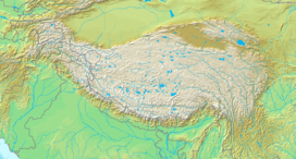
 Nanga Parbat
Location Gilgit-Baltistan, Pakistan[1] Range Himalayas Coordinates 35°14′15″N 74°35′21″E / 35.2375°N 74.58917°ECoordinates: 35°14′15″N 74°35′21″E / 35.2375°N 74.58917°E Climbing First ascent July 3, 1953 by Hermann Buhl Easiest route Diamir (West Face) Nanga Parbat (literally, Naked Mountain from Hindi: नंगा परबत, Urdu: ننگا پربت [nəŋɡaː pərbət̪]) is the ninth highest mountain on Earth, the second highest mountain in Pakistan and among the eight-thousanders with a summit elevation of 8,126 meters (26,660 ft). Nanga Parbat translates to "Naked Mountain" in English; parbat deriving from the Sanskrit word parvata (पर्वत) meaning "mountain, rock", and nanga from the Sanskrit nagna (नग्न) meaning "naked".[2] Known as the "Killer Mountain", Nanga Parbat was one of the deadliest of the eight-thousanders for climbers in the first half of the twentieth century; since that time it has been less so, though still an extremely serious climb. It is also an immense, dramatic peak that rises far above its surrounding terrain.
Contents
Location
Nanga Parbat forms the western anchor of the Himalayan Range and is the westernmost eight-thousander. It lies just south of the Indus River in the Astore District of Gilgit-Baltistan in Pakistan-administered Kashmir.[1] Not far to the north is the western end of the Karakoram range.
Notable features
Nanga Parbat has tremendous vertical relief over local terrain in all directions.
To the south, Nanga Parbat boasts what is often referred to as the highest mountain face in the world: the Rupal Face rises 4,600 m (15,000 ft) above its base. To the north, the complex, somewhat more gently sloped Rakhiot Flank rises 7,000 m (23,000 ft) from the Indus River valley to the summit in just 25 km (16 mi), one of the 10 greatest elevation gains in so short a distance on Earth.[citation needed]
Nanga Parbat is one of only two peaks on Earth that rank in the top twenty of both the highest mountains in the world, and the most prominent peaks in the world, ranking ninth and fourteenth respectively. The other being Mount Everest, which is first on both lists.
Layout of the mountain
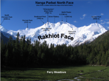 Nanga Parbat Rakhiot Face
The core of Nanga Parbat is a long ridge trending southwest–northeast. The ridge is an enormous bulk of ice and rock. It has three faces, Diamir face, Rakhiot and Rupal. The southwestern portion of this main ridge is known as the Mazeno Wall, and has a number of subsidiary peaks. In the other direction, the main ridge arcs northeast at Rakhiot Peak (7,070 m / 23,196 ft). The south/southeast side of the mountain is dominated by the massive Rupal Face, noted above. The north/northwest side of the mountain, leading to the Indus, is more complex. It is split into the Diamir (west) face and the Rakhiot (north) face by a long ridge. There are a number of subsidiary summits, including North Peak (7,816 m / 25,643 ft) some 3 km north of the main summit. Near the base of the Rupal Face is a beautiful glacial lake called Latbo, above a seasonal shepherds' village of the same name.
Climbing history
 Nanga Parbat from Deosai
Early attempts
Climbing attempts started very early on Nanga Parbat. In 1895 Albert F. Mummery led an expedition to the peak, and reached almost 7,000 m (23,000 ft) on the Diamir (West) Face, but Mummery and two Gurkha companions later died reconnoitering the Rakhiot Face.
In the 1930s, Nanga Parbat became the focus of German interest in the Himalaya. The German mountaineers were unable to attempt Mount Everest, as only the British had access to Tibet. Initially German efforts focussed on Kanchenjunga, to which Paul Bauer led two expeditions in 1930 and 1931, but with its long ridges and steep faces Kanchenjunga was more difficult than Everest and neither expedition made much progress. K2 was known to be harder still, and its remoteness meant that even reaching its base would be a major undertaking. Nanga Parbat was therefore the highest mountain accessible to Germans which they seemed to have a chance of climbing.[3]
 Approaching Nanga Parbat Base Camp
The first German expedition to Nanga Parbat was led by Willy Merkl in 1932. It is sometimes referred to as a German-American expedition, as the eight climbers included Rand Herron, an American, and Fritz Wiessner, who would become an American citizen the following year. While the team were all strong climbers, none had Himalayan experience, and poor planning (particularly an inadequate number of porters), coupled with bad weather, prevented the team progressing far beyond the Rakhiot Peak, reached by Peter Aschenbrenner and Herbert Kunigk, but they did establish the feasibility of a route via Rakhiot Peak and the main ridge.[4]
Merkl led another expedition in 1934, which was better prepared and financed with the full backing of the new Nazi government. Early in the expedition Alfred Drexel died, probably of high altitude pulmonary edema,.[5] The Tyrolean climbers Peter Aschenbrenner and Erwin Schneider reached an estimated height of (7,895 m / 25,900 ft) on July 6, but were forced to return because of worsening weather. On July 7 they and 14 others were trapped by a ferocious storm at 7,480 m (24,540 ft). During the desperate retreat that followed, three famous German mountaineers, Uli Wieland, Willo Welzenbach and Merkl himself, and six Sherpas died of exhaustion, exposure and altitude sickness, and several more suffered severe frostbite. The last survivor to reach safety, Ang Tsering, did so having spent seven days battling through the storm.[6] It has been said that the disaster, "for sheer protracted agony, has no parallel in climbing annals."[7]
In 1937, Karl Wien led another expedition to the mountain, following the same route as Merkl's expeditions had done. Progress was made, but more slowly than before due to heavy snowfall. Some time around the 14th of June seven Germans and nine Sherpas, almost the entire team, were at Camp IV below Raikot Peak when it was overwhelmed by an avalanche. All sixteen men died instantly in what remains the worst single disaster to occur on an 8000 m peak.[8]
The Germans returned in 1938 led by Paul Bauer, but the expedition was plagued by bad weather, and Bauer, mindful of the previous disasters, ordered the party down before the Silver Saddle was reached.[9] The following year a small four man expedition, including Heinrich Harrer, explored the Diamir Face with the aim of finding an easier route. They concluded that the face was a viable route, but the Second World War intervened and the four men were interned in India.[10] Harrer's escape and subsequent travels became the subject of his book Seven Years in Tibet.
First ascent
 Southwest aspect of the Rupal Face
 At 4,100 m (13,450 ft), near the Rakhiot Base Camp
 View from Latbo village. For a sense of scale, notice a 4-man yellow tent, dwarfed by the peak, near the bottom right. Just above the tent is a large white building.
Nanga Parbat was first climbed, via the Rakhiot Flank (East Ridge), on July 3, 1953 by Austrian climber Hermann Buhl,[11] a member of a German-Austrian team. The expedition was organized by the half-brother of Willy Merkl, Karl Herrligkoffer from Munich, while the expedition leader was Peter Aschenbrenner from Innsbruck, who had participated in the 1932 and 1934 attempts. By the time of this expedition, 31 people had already died on the mountain.[12] The final push for the summit was dramatic: Buhl continued alone, after his companions had turned back, and arrived at 7 p.m.; the climbing being harder and more time consuming than he had anticipated. His descent was slowed when he lost a crampon. Caught by darkness, he was forced to bivouac standing upright on a narrow ledge, holding a small handhold with one hand. Exhausted, he dozed occasionally, but managed to maintain his balance. He was also very fortunate to have a calm night, so he was not subjected to wind chill. He finally reached his high camp at 7 p.m. the next day, 40 hours after setting out.[13] The ascent was made without oxygen, and Buhl is the only man to have made the first ascent of an 8000 m peak alone.
Subsequent attempts and ascents
The second ascent of Nanga Parbat was via the Diamir Face, in 1962, by Germans Toni Kinshofer, S. Löw, and A. Mannhardt. The route is now the "standard route" on the mountain. The Kinshofer route does not ascend the middle of the Diamir Face, which is threatened by avalanches from massive hanging glaciers. Instead it climbs a buttress on the left side of the face.
In 1970 the brothers Günther and Reinhold Messner reached the summit via a direct route on the huge, difficult Rupal Face; this was the third ascent of the mountain. Their descent was epic: they were unable to descend their ascent route, and instead made the first traverse of the mountain, going down the Diamir Face. Unfortunately Günther was killed in an avalanche on the Diamir. (Messner's account of this incident has been disputed. In 2005 Günther's remains were found on the Diamir Face.)
In 1971 Ivan Fiala and Michael Orolin summited Nanga Parbat via Buhl's 1953 route while other expedition members climbed the SE peak (7,600 m / 24,925 ft) above the Silbersattel and the foresummit (7,850 m / 25,760 ft) above the Bazhin Gap.
In 1978 Reinhold Messner returned to the Diamir Face and achieved the first completely solo ascent (i.e. always solo above Base Camp) of an 8,000 m peak.
In 1984 the French climber Lilliane Barrard became the first woman to climb Nanga Parbat, along with her husband Maurice Barrard.
In 1985, Jerzy Kukuczka, Zygmunt Heinrich, Slawomir Lobodzinski (all Polish) and Carlos Carsolio (Mexico) climbed a bold line up the Southeast Pillar (or Polish Spur) on the right-hand side of the Rupal Face, reaching the summit July 13.. It was Kukuczka's 9th 8000m summit.[14]
Also in 1985, a Polish women's team climbed the peak via the 1962 German Diamir Face route. Wanda Rutkiewicz, Krystyna Palmowska and Anna Czerwinska reached the summit on July 15.[14]
"Modern" superalpinism was brought to Nanga Parbat in 1988 with an unsuccessful attempt or two on the Rupal Face by Barry Blanchard, Mark Twight, Ward Robinson and Kevin Doyle.[15]
Summer 2005 saw a resurgence of lightweight, alpine-style attempts on the Rupal Face:
- In August 2005, Pakistani military helicopters rescued Slovenian mountaineer Tomaž Humar, who was stuck under a narrow ice ledge at 5,900 m (19,400 ft) for six days. It is believed to be one of the few successful rescues carried out at such high altitude.[16]
- In September 2005, Vince Anderson and Steve House did an extremely lightweight, fast ascent of a new, direct route on the face, earning high praise from the climbing community.[17]
On the 17th or 18 July 2006, José Antonio Delgado Sucre, a climber from Venezuela, died a few days after making the summit, where he was caught by bad weather for 6 days and was unable to make his way down. He was the only Venezuelan climber, and one of the few Latin Americans, to have reached the summit of five eight-thousanders.[18] Part of the expedition and the rescue efforts at base camp were captured on video as José Antonio Delgado Sucre was the subject of a pilot for a mountaineering television series.[18] Explorart Films, the production company, later developed the project into a feature documentary film called Beyond the Summit, which was scheduled to be released theatrically in South America in January 2008.[19]
On July 15, 2008, Italian alpinist Karl Unterkircher fell into a crevasse during an attempt to open, with Walter Nones and Simon Kehrer, a new route to the top. Unterkircher died, but Simon Kehrer and Walter Nones were rescued by the Pakistani rescue team after many efforts.[20]
On July 12, 2009, after reaching the top of Nanga Parbat, South Korean climber Go Mi-Young fell off a cliff on the descent in bad weather. In her race to be the first woman to climb the 14 of the worlds highest peaks (the Eight Thousanders).[21]
Nanga Parbat has never been climbed in winter.
References in popular culture
Books
In the first chapter of Mistress of Mistresses, by E.R. Eddison, the narrator compares his now deceased compatriot, Lessingham, to Nanga Parbat in a descriptive passage:
- "I remember, years later, his describing to me the effect of the sudden view you get of Nanga Parbat from one of those Kashmir valleys; you have been riding for hours among quiet richly wooded scenery, winding up along the side of some kind of gorge, with nothing very big to look at, just lush, leafy, pussy-cat country of steep hillsides and waterfalls; then suddenly you come round a corner where the view opens up the valley, and you are almost struck senseless by the blinding splendour of that vast face of ice-hung precipices and soaring ridges, sixteen thousand feet from top to toe, filling a whole quarter of the heavens at a distance of, I suppose, only a dozen miles. And now, whenever I call to mind my first sight of Lessingham in that little daleside church so many years ago, I think of Nanga Parbat." (MoM, 1967, p.2-3)
Movies
Nanga Parbat (2010) A movie by Joseph Vilsmaier about the tragic expedition by the two Messner brothers in 1970, on which Reinhold Messner's younger brother Günther died.[22]
Nearby peaks
See also
- Highest Mountains of the World
- Rupal Valley
- Astore Valley
- Hassan sadpara
Notes
- ^ a b c Nanga Parbat lies on the western side of the Line of Control in Pakistan-administered Kashmir.
- ^ Sanskrit, Tamil and Pahlavi Dictionaries
- ^ Neale, Jonathan (2002). Tigers of the Snow. St Martin's Press. pp. 63–64. ISBN 0312266235.
- ^ Mason, Kenneth (1955). Abode of the Snow. Rupert Hart-Davis. pp. 226–228.Reprinted 1987 by Diadem Books, ISBN 978-0-906371-91-6
- ^ Neale, pp.123-130
- ^ Mason pp. 230-233
- ^ Simpson, Joe (1997). Dark Shadows Falling. London: Jonathan Cape. pp. 196–197. ISBN 0224043684.
- ^ Neale, pp.212-213
- ^ Mason pp.236-237
- ^ Mason pp.238-239
- ^ nangaroutesnew.pdf, Eberhard Jurgalski (rosemon), last updated 17 June 2010, retrieved from http://www.8000ers.com/cms/en/nanga-parbat-general-info-197.html 22 July 2011.
- ^ This includes two British climbers who disappeared low on the mountain in December 1950. They were studying conditions on the Rakhoit glacier, not attempting the summit. See Mason p.306.
- ^ Sale, Richard; Cleare, John (2000). Climbing the World's 14 Highest Mountains: The History of the 8,000-Meter Peaks. Seattle: Mountaineers Books. pp. 72–73. ISBN 978-0898867275.
- ^ a b "Basecamp", Climbing Magazine (93): 22, December 1995, ISSN 0045-7159
- ^ Twight, Mark (2001). Kiss or kill: confessions of a serial climber. Seattle WA, USA: The Mountaineers Books. ISBN 0-89886-887-4.
- ^ "Climber rescued from major peak". BBC News. 10 August 2005. http://news.bbc.co.uk/1/hi/world/south_asia/4137160.stm. Retrieved 2008-04-22.
- ^ Alpinist 15 on the Anderson/House ascent
- ^ a b NANGA PARBAT 2006
- ^ Mas Alla de la Cumbre - Beyond the Summit
- ^ "Star' climber dies in Himalayas". Ansa. 2008-07-16. http://www.ansa.it/site/notizie/awnplus/english/news/2008-07-16_116252496.html. Retrieved 2008-07-17.[dead link]
- ^ Korean Alpinist Go Mi-sun Dies After Fall on Nanga Parbat (About.com)
- ^ Official film website
Sources
- Herrligkoffer, Karl M., Nanga Parbat. Elek Books, 1954.
- Irving, R. L. G., Ten Great Mountains (London, J. M. Dent & Sons, 1940)
- Ahmed Hasan Dani, Chilas: The City of Nanga Parvat (Dyamar). 1983. ASIN B0000CQDB2
- Alpenvereinskarte "Nanga Parbat", 1:50,000, Deutsche Himalaya Expedition 1934.
- Andy Fanshawe and Stephen Venables, Himalaya Alpine-Style, Hodder and Stoughton, 1995.
- Audrey Salkeld (editor), World Mountaineering, Bulfinch, 1998.
- American Alpine Journal
- Himalayan Index
- DEM files for the Himalaya (Corrected versions of SRTM data)
- Guardian International story on Gunther Messner
- Climbing magazine, April 2006.
Further Reading
- Buhl, Herman, Nanga Parbat Pilgrimage, London, Hodder and Stoughton, 1956, ISBN 0340264985
- Messner, Reinhold, Solo Nanga Parbat, London, Kale and Ward, 1980, ISBN 0718212509 (Britain), ISBN 0195201965 (USA)
External links
- Nanga Parbat on Peakware
- Nanga Parbat on summitpost.org
- A mountain list ranked by local relief and steepness showing Nanga Parbat as the World #1
Eight-thousanders Everest · K2 · Kangchenjunga · Lhotse · Makalu · Cho Oyu · Dhaulagiri · Manaslu · Nanga Parbat · Annapurna · Gasherbrum I · Broad Peak · Gasherbrum II · XixabangmaCategories:- Mountains of Pakistan
- Eight-thousanders
- Astore District
- Himalayas


Wikimedia Foundation. 2010.