- Mount Wellington (Tasmania)
-
Mount Wellington 
Mount WellingtonElevation 1,271 m (4,170 ft) AHD Location Location Tasmania, Australia Range Wellington Range Coordinates 42°53′57″S 147°13′57″E / 42.89917°S 147.2325°ECoordinates: 42°53′57″S 147°13′57″E / 42.89917°S 147.2325°E Climbing First ascent 25 Dec 1798 by George Bass
(May have been a partial climb)
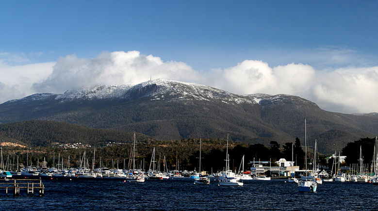
18 Feb 1804 - Robert BrownEasiest route Hike, road Mount Wellington is a mountain on whose foothills is built much of the city of Hobart, Tasmania, Australia. It is often referred to simply as 'the Mountain' by the residents of Hobart, and it rises to 1,271 metres (4,170 ft) AHD over the city.
It is frequently snow covered, sometimes even in summer and the lower slopes are thickly forested, but criss-crossed by many walking tracks and a few fire trails. There is also a sealed but narrow road to the summit, about 22 kilometres (14 mi) travel from the city. An enclosed lookout near the summit provides spectacular views of the city below and to the east, the Derwent estuary, and also glimpses of the World Heritage Area nearly 100 kilometres (62 mi) to the west.
From Hobart, the most distinctive feature of Mount Wellington is the cliff of dolerite columns known as the Organ Pipes.
Contents
History
The low-lying areas and foothills of Mount Wellington were formed by slow geological upsurge when the whole Hobart area was a low-lying cold shallow seabed. The upper reaches of the mountain were formed more violently, as a Sill with a tabular mass of igneous rock that has been intruded laterally between layers of older rock pushing upwards by upsurges of molten rock as the Australian continental shelf tore away from Antarctica, and separated from Gondwana over 40 million years ago. It is often incorrectly considered to be a dormant volcano.
Mount Wellington was originally referred to as Unghbanyahletta (or Ungyhaletta), Poorawetter (or ‘'Pooranetere'’, also Pooranetteri), or Kunanyi to the indigenous people of Tasmania. The Palawa, the surviving descendants of the original indigenous Tasmanians, tend to prefer the latter name. The indigenous population are believed to have arrived in Tasmania approximately 30-40,000 years ago. Their beliefs and traditions, coupled with modern archaeological research, suggest that they may have occupied and utilised the mountain and its surrounding areas for much of the occupation of the island.
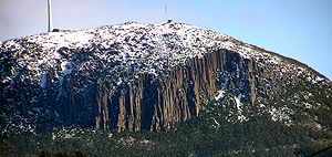 Organ Pipes at the top of the mountain
The first recorded European in the area Abel Tasman probably did not see the mountain in 1642, as his ship was quite a distance out to sea as he sailed up the South East coast of the island - coming closer in near present day North and Marion Bays.
No other Europeans visited Tasmania until the late eighteenth century, when several visited southern Tasmania (then referred to as Van Diemens Land) including Frenchman Marion du Fresne (1772), Englishmen Tobias Furneaux (1773), James Cook (1777) and William Bligh (1788 and 1792), and Frenchman Bruni d'Entrecasteaux (1792–93). In 1793 Commodore John Hayes arrived at the Derwent River, nameing the mountain Skiddaw, after the mountain in the Lake District, although this name never gained popularity.
In 1798 Matthew Flinders and George Bass circumnavigated the island. Whilst they were resting in the area Flinders named the river the Derwent River (the name John Hayes had given only to the upper part of the river),[1] Flinders referred to the mountain as ‘Table Mountain’ (the name given to it by Bond and Bligh - young Matthew Flinders was with them in 1791) for its similarity in appearance to Table Mountain in South Africa. Bruni d'Entrecasteaux's men where the first European to sail up the river and chart it. Later Nicholas Baudin led another French expedition in 1802, and whilst sheltering in the Derwent River (which they referred to as ‘River du Nord’ - the name d'Entrecasteaux had given to it) Baudin also referred to the mountain as ‘Montagne du Plateau’ (also named by d'Entrecasteaux). However, the British first settled in the Hobart area in 1804, resulting in Flinders’ name of ‘Table Mountain’ becoming more popular.
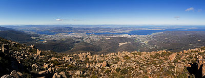 Greater Hobart area from Mount Wellington
Table Mountain remained its common name until in 1832 it was decided to rename the mountain in honour of the Duke of Wellington who, with Gebhard Leberecht von Blücher finally defeated Napoleon at the Battle of Waterloo in present-day Belgium on 18 June 1815.
Throughout the 19th and into the 20th centuries, the Mountain was a popular day-resort for residents of Hobart. To that end, many excursion huts were built over the lower slopes of the mountain. However, none of these early huts survive as they were all destroyed during the disastrous bushfires of 1967, though modern huts are open to the public at the Springs, the Pinnacle, the Chalet - a picnic spot about halfway between the Springs and the Pinnacle - and elsewhere. Sadly, many of the more remote huts have suffered from vandalism, and some are in virtually derelict condition.
In February 1836, Charles Darwin visited Hobart Town and climbed Mount Wellington. In his book "The Voyage of the Beagle", Darwin described the mountain thus;
"... In many parts the Eucalypti grew to a great size, and composed a noble forest. In some of the dampest ravines, tree-ferns flourished in an extraordinary manner; I saw one which must have been at least twenty feet high to the base of the fronds, and was in girth exactly six feet. The fronds forming the most elegant parasols, produced a gloomy shade, like that of the first hour of the night. The summit of the mountain is broad and flat, and is composed of huge angular masses of naked greenstone. Its elevation is 3,100 feet [940 m] above the level of the sea. The day was splendidly clear, and we enjoyed a most extensive view; to the north, the country appeared a mass of wooded mountains, of about the same height with that on which we were standing, and with an equally tame outline: to the south the broken land and water, forming many intricate bays, was mapped with clearness before us. ..."
The Mountain has played host to some notorious characters over time, especially the bushranger 'Rocky' Whelan, who murdered several bushwalkers through the early 19th century. The cave where he lived is known appropriately as 'Rocky Whelan's Cave', and is an easy walk from the Springs.
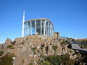 The lookout building near the summit, with the main television and radio transmitter in the background.
The road to the summit was constructed in the early 1930s as a relief scheme for the unemployed, an idea initiated by Albert Ogilvie, the Premier of Tasmania of the day. While the road is officially known as the Pinnacle Drive, it was, for some time, also widely known among residents of Hobart as 'Ogilvie's Scar' because at the time it was constructed 'the Mountain' was heavily logged and almost bare, and the road was an all-too-obvious scar across the already denuded mountain. Today the trees have grown again but the 'scar' most people see today is not actually the road but a line of large rocks with no trees 50–100 m above the road, provided as an easement for power lines. The road itself was opened in August 1937, after nearly two years of work, by Governor Sir Ernest Clark.
Halfway up this road is a picnic area called "The Springs", near the site of a chalet/health spa that was destroyed by bushfire in 1967.
Mount Wellington was selected by many broadcasters as the site of broadcast radio and television transmitters because it provides line-of-sight transmission to a much larger area of Hobart and surrounding districts than any other point in the region. The first television stations to transmit from there were TVT-6 (now WIN Television) and ABT-2 (the ABC) in 1960. The mountain has two main transmission towers located at its pinnacle. One is the concrete and steel constructed Broadcast Australia Tower (sometimes referred to as the NTA Tower) and one owned by WIN television which is of steel construction. The NTA tower broadcasts all of Hobart's high power FM radio stations, and ABC, SBS and Southern Cross analogue Television services, plus the digital services for ABC and SBS. The NTA tower also has a small accommodation area at its base with kitchen and workshop area. The WIN TV tower has TVT6's analogue TV services transmitted from it as well as the digital services from Southern Cross, Win TV, and Tasmanian Digital Television. The site also contains a small kitchen area and contains some data links from local Hobart businesses.
The first weather station was set up on Mount Wellington in 1895 by Clement Lindley Wragge.
A cable car development has been proposed for the mountain on various occasions, but public opposition has so far prevented any major developments.
Climate
The mountain significantly influences Hobart's weather, and intending visitors to the summit are advised to dress warmly against the often icy winds at the summit, which have been recorded at sustained speeds of over 157 km/h (97 mph), with rare gusts of up to 200 km/h (124 mph). In the winter it often snows and the mountain is often snowcapped. Lighter snowfalls in spring, summer and Autumn are also common. A day on the summit can consist of clear sunny skies, then rain, then snow, then icy winds and then clear again.
Climate data for Mount Wellington Month Jan Feb Mar Apr May Jun Jul Aug Sep Oct Nov Dec Year Record high °C (°F) 29.2
(84.6)29.6
(85.3)34.5
(94.1)24.7
(76.5)14.9
(58.8)13.3
(55.9)9.8
(49.6)13.4
(56.1)19.5
(67.1)22.0
(71.6)26.2
(79.2)27.5
(81.5)34.5
(94.1)Average high °C (°F) 13.2
(55.8)13.6
(56.5)11.3
(52.3)8.3
(46.9)5.6
(42.1)3.5
(38.3)2.3
(36.1)2.6
(36.7)4.3
(39.7)7.0
(44.6)9.0
(48.2)10.9
(51.6)7.6 Average low °C (°F) 4.7
(40.5)5.3
(41.5)4.0
(39.2)2.1
(35.8)0.5
(32.9)−0.8
(30.6)−1.6
(29.1)−1.8
(28.8)−1.4
(29.5)0.0
(32.0)1.4
(34.5)2.8
(37.0)1.3 Record low °C (°F) −3.4
(25.9)−7.4
(18.7)−4.7
(23.5)−6.5
(20.3)−8.1
(17.4)−7.5
(18.5)−8.1
(17.4)−7.8
(18.0)−9.1
(15.6)−7.7
(18.1)−6.2
(20.8)−4.4
(24.1)−9.1
(15.6)Precipitation mm (inches) 83.3
(3.28)79.5
(3.13)74.2
(2.921)85.3
(3.358)62.2
(2.449)63.3
(2.492)75.9
(2.988)76.2
(3)65.4
(2.575)77.6
(3.055)81.7
(3.217)88.6
(3.488)917.3
(36.114)Source: Bureau of Meteorology[2] References
- ^ Observations on the coasts of Van Diemen's Land by Matthew Flinders published in 1801 page 5
- ^ "Climate Statistics for Mount Wellington". Australian Government. Bureau of Meteorology. http://www.bom.gov.au/climate/averages/tables/cw_094087_All.shtml. Retrieved 31 October 2009.
Further reading
- '208 Network'. (1994) Mt. Wellington - Mountain Park resource management plan and master plan for the Corporation of the City of Hobart : final draft for public comment : Hobart : 208 Network. "The 208 Network is John Hepper, Jerry de Gryse, with assistance from Chris Sharples, Fred and Diana Duncan, Robert Taylor, Hilary du Cros, Lindy Scripps, Greg Hodge".
- Curtis, Winifred M. (Winifred Mary) (n.d.) Forests and flowers of Mount Wellington, Tasmania illustrated by D. Colbron Pearse. [Hobart]: Tasmanian Museum and Art Gallery.
- de Quincey, Elizabeth and Cannon, John (2005) The Companion to Tasmanian History p. 245 - entry "Mount Wellington"
- Observations on the coasts of Van Diemen's Land, on Bass's Strait and its islands, and on parts of the coasts of New South Wales; intended to accompany the charts of the late discoveries in those countries. By Matthew Flinders, second lieutenat of His Majesty's Ship Reliance.published by John Nichols 1801*
External links
- Mount Wellington official website
- Webcam showing the Tasman Bridge in Hobart with Mount Wellington in background
Hobart landmarks Buildings & Structures: 10 Murray Street · Cascade Brewery · Hotel Grand Chancellor · Museum of Old and New Art · NAB Building · Parliament House · Parliament Square · State Library · Supreme Court · Tasmanian Museum and Art Gallery · The Old Woolstore Apartment Hotel · Wrest PointEntertainment: Sports: Bellerive Oval · Domain Athletic Centre · Hobart Aquatic Centre · Hobart International Tennis Centre · KGV Oval · Kingborough Sports Centre · North Hobart Oval · Tattersalls ParkTransportation: Nature and Parks: Precincts: Salamanca · Sullivans CoveCategories:- Landmarks in Hobart
- Mountains of Tasmania


Wikimedia Foundation. 2010.