- Market Drayton
-
Coordinates: 52°54′16″N 2°29′05″W / 52.9044°N 2.4848°W
Market Drayton 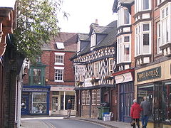
Tudor House Hotel, at the corner of Cheshire Street and Shropshire Street.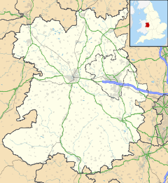
 Market Drayton
Market Drayton shown within ShropshirePopulation 10,407 OS grid reference SJ673321 Unitary authority Shropshire Ceremonial county Shropshire Region West Midlands Country England Sovereign state United Kingdom Post town MARKET DRAYTON Postcode district TF9 Dialling code 01630 Police West Mercia Fire Shropshire Ambulance West Midlands EU Parliament West Midlands UK Parliament North Shropshire List of places: UK • England • Shropshire Market Drayton is a small market town in north Shropshire, England. It is on the River Tern, between Shrewsbury and Stoke-on-Trent, and was formerly known as "Drayton in Hales" (c. 1868) and earlier simply as "Drayton" (c. 1695). Market Drayton is on the Shropshire Union Canal and on Regional Cycle Route 75. The A53 road by-passes the town.
Contents
Industry
In 1965, sausage maker Palethorpe's built a new factory employing 400 people in the town. Purchased by Northern Foods in 1990, the company was merged with Bowyers of Trowbridge, Wiltshire and Pork Farms of Nottingham to form Pork Farms Bowyers. The sausage brand was sold in 2001 to Kerry Group, but the factory remains open to this day as the town's largest employer. It produces various meat based and chilled food products, under both the Pork Farms brand and for third parties, including Asda.
Müller Dairies have a factory making yoghurts. The town is also the home of Tern Press, a highly respected and collectible small press publisher of poetry. Image on Food also makes local gingerbread.
Recent developments in the local service industry include the retailers Argos, Wilkinsons, Subway and B & M which have all brought new employment to the town.
Sites of Interest
The great fire of Drayton destroyed almost 70% of the town in the 17th century. It was started at a bakery, and quickly spread through the timber buildings. The Buttercross in the centre of the town still has a bell at the top for people to ring if there was ever another fire.
Ancient local sites include: Audley's Cross, Blore Heath, and several Neolithic standing stones, "The Devil's Ring and Finger", just three miles (5 km) from the town.
Other notable landmarks in the area include: Pell Wall Hall, Adderley Hall, Buntingsdale Hall, Salisbury Hill, Tyrley Locks on the Shropshire Union Canal and the Thomas Telford designed aqueduct. Fordhall Farm, consists of 140 acres (0.57 km2) of community-owned organic farmland located off of the A53 between the Müller and Tern Hill roundabouts. The farm trail is open to the public during farm shop opening hours, and included along the path is the site of an ancient motte and bailey structure which overlooks the River Tern valley.
To the south-east near the A529 an eighteenth-century farmhouse stands on the site of Tyrley Castle, which was probably built soon after 1066 and later rebuilt in stone in the thirteenth century.
Many of the streets in the town are named after famous castles, such as Balmoral Drive, Caernavon Close, Windsor Drive, Warwick Close, and many others.
-

Aqueduct
-

St. Mary's Church
-
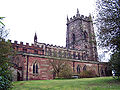
St. Mary's Church
-

Tyrley Locks
-

Pell Wall Hall
Notable residents
Nearby at Styche Hall is the birthplace of Robert Clive, first Lord Clive, "Clive of India", 1725–1774. The Georgian house, designed by Sir William Chambers, the architect of Somerset House, replaced the half-timbered house where Clive was born. It was built for his father and paid for by Clive from the income from his Indian career.
Amongst the many schools he attended is the town's old grammar school, next to St Mary's church. A school desk with the initials RC can still be seen in the town.
The town was the birthplace of pioneering photographer Samuel Bourne (b. 1834). He is famous for having spent six years in India from 1862 to 1870;[1] there he founded a major studio, Bourne & Shepherd, trekked into and photographed many of India's remotest places and, with his printer Charles Shepherd, became the most notable photographer of the Raj.
The 1930s British fascist leader Oswald Mosley was born nearby in 1896, at Betton Hall, the home of his mother's parents. On the separation of his parents, his mother, Oswald and his brother went to live in Smithfield Road. Mosley attended a dame school in Shropshire Street until he went to public school at the age of eight. Apart from holidays he never lived in Drayton again.
Mosley was deeply ashamed of their reduced circumstances and he did everything to hide the years in Drayton. Their middle class status contrasted with the huge estate of his paternal grandparents in Staffordshire. Y ears later, following the death of their mother, he obtained her diaries from his brother and burned them. In the 1930s at the height of his "fame", he returned to the town where he held a meeting in the square.
The most famous,[2] recent inhabitant was a petty criminal (he admitted to being a poacher)called Derek "Poddy" Podmore. He had a fan club in Philadelphia called Pod's People, selling badges to Americans. Just before Christmas in 1977, dressed as Father Christmas, and shouting "Merry Christmas", he sat on to the roof of Shrewsbury jail with a sack of cigarettes and tobacco for the inmates. He was arrested after an hour, by means of a Green Goddess[3] fire engine He also had himself nailed by the ear to a tree. He once appeared in court covered in manure wearing a dead pig as a hat. He also appeared in court dressed as a frogman - this followed his "warm-up" for a world frog swallowing record attempt in 1974 when he swallowed a live frog at a Market Drayton pub and washed it down with a pint of "black and tan". 'Poddy' is also said to have paid a substantial fine in 1 pence pieces, which he took to court in sacks (which, of course, meant the court had to count up every sack).
Market Drayton has always been a hotbed for musical 'talent' producing a number of bands who have progressed on to achieve regional acclaim. In the early 1980s the town boasted the 'best' School Rock Band in the country, TSB National School Band winners, Monovision. At the same time the local youth club were represented by the Platinum Needles[4] in the NAYC Opportunity Rocks competition final. In early 1981 The Platinum Needles were also featured on the Stoke Musicians Collective album released on Slip Records "Cry Havoc".[5] The Frolics, another band from the Grove School had success in the West Midlands area and generated a cult following locally. In more recent times Sonic State another local band have produced the theme music for a TV program while sharing their lead singer Jenny Z with the more famous Sigue Sigue Sputnik (formed by former Generation X guitarist Tony James). During the late seventies and early eighties, Drayton also boasted one of the only recording studios in Shropshire, Redball Records.
Education
Market Drayton has 4 schools:
- Longlands Primary School
- Market Drayton Infant School
- Market Drayton Junior School
- Grove School (Market Drayton)(and sixth form college)
The Grove School is a large secondary school, of approximately 1100 students all of whom are located within 12 miles (19 km) of the town.
Sister cities
Market Drayton is twinned with:[6]
References
- ^ Photographs of India. circa 1862 - circa 1872 - Samuel Bourne Biography Cambridge University Library.
- ^ http://www.shropshirestar.com/features/minisites/starhistory/downloads/40years_p2_pdfs/star3.pdf
- ^ http://news.bbc.co.uk/1/hi/uk/2346157.stm
- ^ http://www.platinum-needles.co.uk/history.html
- ^ http://stokebeat.yolasite.com/
- ^ Arlon Twinning on Council site
External links
- Shropshire Tourism The official tourism website for Shropshire
- Market Drayton Council
- The Grove School
- Market Drayton Tigers Junior Football Club
- TF9 Online - Community site for the Market Drayton area
- The Phoenix Badminton Club
- The Platinum Needles - a local punk rock group who enjoyed moderate national acclaim in the early 1980s
- Early 80s Drayton Youth Market Drayton Youth Club activities in the early 1980s
- St. Mary's Church
- Market Drayton Methodist Church
- http://www.picturesofengland.com/England/Shropshire/Market_Drayton/pictures/10209
Ceremonial county of Shropshire Boroughs or districts Major settlements Bishop's Castle • Bridgnorth • Broseley • Church Stretton • Cleobury Mortimer • Clun • Craven Arms • Ellesmere • Ludlow • Market Drayton • Much Wenlock • Newport • Oswestry • Shifnal • Shrewsbury • Telford (Dawley • Madeley • Oakengates • Wellington) • Wem • Whitchurch
See also: List of civil parishes in ShropshireRivers Topics Categories:- Market towns in Shropshire
- Towns in Shropshire
-


Wikimedia Foundation. 2010.