- Denbighshire
-
County of Denbighshire
Sir Ddinbych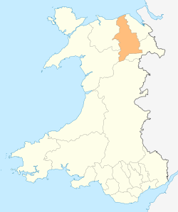
Geography Area
- Total
- % WaterRanked 8th
844 km²
? %Admin HQ Ruthin ISO 3166-2 GB-DEN ONS code 00NG Demographics Population:
- Total (2010 est.)
- Density
Ranked 16th
96,700
Ranked 14th
115 / km²Ethnicity 99.3% White. Welsh language
- Any skillsRanked 6th
36.0%Politics 
Denbighshire County Council
http://www.denbighshire.gov.uk/Control NOC (Independent-led coalition) MPs - David Jones
- Susan Jones
- Chris Ruane
AMs - Karen Sinclair
- Ann Jones
- Darren Millar
(Constituency) - North Wales
(Regional)
MEPs Wales Denbighshire (Welsh: Sir Ddinbych) is a county in north-east Wales. It is named after the historic county of Denbighshire, but has substantially different borders. Denbighshire has the distinction of being the oldest inhabited part of Wales. Pontnewydd (Bontnewydd-Llanelwy) Palaeolithic site has remains of Neanderthals from 225,000 years ago. There are several castles in the region- Denbigh Castle, Rhuddlan Castle, Ruthin Castle, Castell Dinas Bran and Bodelwyddan Castle.
Contents
Formation
The present principal area was formed on April 1, 1996, under the Local Government (Wales) Act 1994, from various parts of the county of Clwyd. It included the district of Rhuddlan (which was formed in 1974 entirely from Flintshire), the communities of Trefnant and Cefn Meiriadog from the district of Colwyn (which was entirely Denbighshire) and most of the Glyndŵr district. The part of the Glyndŵr district included the entirety of the former Edeyrnion Rural District, which was part of the administrative county of Merionethshire prior to 1974 – which covered the parishes of Betws Gwerfil Goch, Corwen, Gwyddelwern, Llangar, Llandrillo yn Edeirnion and Llansanffraid.
Other principal areas containing part of historic Denbighshire are Conwy, which picked up the remainder of the 1974–1996 Colwyn, and also the Denbighshire parts of the 1974–1996 Aberconwy, and Wrexham, which corresponds to the pre-1974 borough of Wrexham along with most of the Wrexham Rural District and also several parishes from Glyndŵr.
The post-1996 Powys includes the historic Denbighshire parishes of Llanrhaeadr-ym-Mochnant, Llansilin and Llangedwyn, which had formed part of Glyndŵr district.
Geography
- See List of places in Denbighshire for a list of towns and villages.
The area is mostly hilly moorland, with the Clwydian Range in the east, the Hiraethog Moors (Mynydd Hiraethog) in the west and the Berwyn range adjacent to the southern boundary. The broad, fertile Vale of Clwyd runs south to north in the centre, and there is a narrow coastal plain in the north. Average temperatures are 2°C in January and 19°C in July.
Population
Denbighshire's total population at the United Kingdom Census 2001 was 93,065, with the largest towns on the coast at Rhyl (pop. c.25,000) and Prestatyn (pop. c.18,000). The inland towns are much smaller, Denbigh having a population of 8,500, Ruthin 5,000, and Llangollen 3,300. 28% of the population speaks Welsh, mainly in the upland area and the Vale of Clwyd.
Economy
There are no heavy industrial sites in the county although most of the towns have small industrial parks or estates for light industry, the economy of the area being based on agriculture and tourism. A large proportion of the working population is employed in service industries in the service sector. The uplands support the rearing of sheep and beef cattle, while in the Vale of Clwyd dairy farming and the growing of wheat and barley crops predominates.
On November 19, 2004, Denbighshire was granted Fairtrade County status.
Denbighshire is home to Wales largest Medieval Festival, staged annually over the second weekend in August at Bodelwyddan Castle. It attracts re-enactment groups from all over the country.[citation needed]
See also
- List of Lord Lieutenants of Denbighshire
- List of High Sheriffs of Denbighshire
- Denbighshire (UK Parliament constituency)
- List of places in Denbighshire
External links
- Denbighshire at the Open Directory Project
- [1] Denbighshire landscape
Coordinates: 53°05′12″N 3°21′16″W / 53.08667°N 3.35444°W
Denbighshire Principal settlements 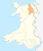
Towns and villages Aberwheeler · Berwyn · Betws Gwerfil Goch · Bodelwyddan · Bodfari · Bontuchel · Bryneglwys · Bylchau · Carrog · Castell · Cefnmeriadog · Cerrigydrudion · Clocaenog · Corwen · Crogen · Cwm · Cyffylliog · Cynwyd · Derwen · Druid · Dyserth · Efenechtyd · Gellifor · Gellioedd · Glasfryn · Glyndyfrdwy · Gronant · Gwaenysgor · Gwyddelwern · Henllan · Hirwaen · Llanarmon-yn-Iâl · Llanbedr-Dyffryn-Clwyd · Llandegla · Llandrillo · Llandyrnog · Llanefydd · Llanelidan · Llanferres · Llanfwrog · Llangar · Llangwyfan · Llangyhafal · Llanrhaeadr-yng-Nghinmeirch · Llansanffraid Glyndyfrdwy · Llantysilio · Llanychan · Llanynys · Llwynmawr · Maerdy · Meliden · Nantglyn · Prion · Pentrecelyn · Rhewl · Rhuallt · Saron · Tafarn Y Gelyn · Trefnant · Trelawnyd · Tremeirchion
Oldest inhabited location Moors Principal areas of Wales Anglesey • Blaenau Gwent • Bridgend • Caerphilly • Cardiff • Carmarthenshire • Ceredigion • Conwy • Denbighshire • Flintshire • Gwynedd • Merthyr Tydfil • Monmouthshire • Neath Port Talbot • Newport • Pembrokeshire • Powys • Rhondda Cynon Taf • Swansea • Torfaen • Vale of Glamorgan • Wrexham
Categories:- Denbighshire
- Counties of Wales
- Principal areas of Wales


Wikimedia Foundation. 2010.