Esplanade Riel

Esplanade Riel

Infobox Bridge
bridge_name = Esplanade Riel


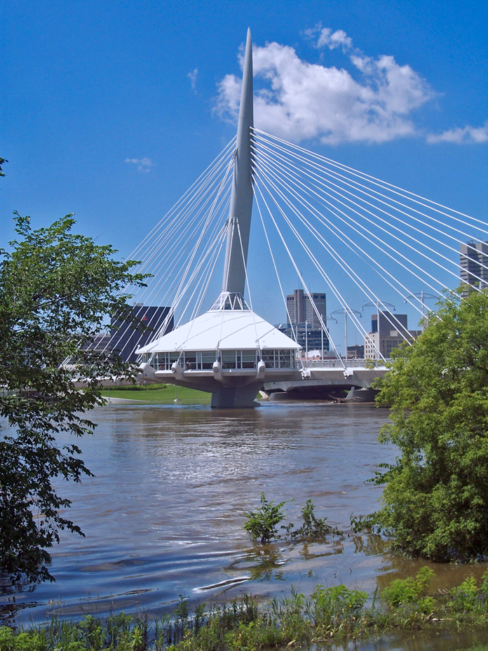
caption = Esplanade Riel pedestrian bridge
official_name = Esplanade Riel
carries =
crosses = Red River
locale = Winnipeg, Manitoba, Canada
maint = City of Winnipeg
id =
designer = Étienne Gaboury
design = Side-spar cable-stayed bridge
material =
spans = 2
pierswater =
mainspan =
length = 197 m
width = 7 m
height =
load =
clearance =
below =
traffic =
begin = 2003
complete = 2004
open =
closed =
toll =
map_cue =
map_

map_text =
map_width =
coordinates =
lat =
long =
The Esplanade Riel is a pedestrian bridge located in Winnipeg, Manitoba designed by Étienne Gaboury of Wardrop Engineering and completed in 2003 [http://www.ciaowinnipeg.com/images/WEG_Riel.pdf] [Structurae|id=s0006036|title=Esplanade Riel Pedestrian Bridge] . It spans the Red River connecting downtown Winnipeg with St. Boniface. It is paired with a vehicular bridge, Provencher Bridge. The bridge is only one of a few in the world in that it has a restaurant (Salisbury House) on it, giving patrons an excellent view of the river and in its rarely seen structure. The Esplanade Riel has become a landmark and is used in many promotional materials. The bridge itself is a side-spar cable-stayed bridge. The original drawing, stamped by Étienne Gaboury, rests in the Engineering building of the University of Manitoba in Winnipeg.

References


Wikimedia Foundation. 2010.

Игры ⚽ Поможем написать реферат

Look at other dictionaries:

  • Esplanade Riel — 49°53′26.8″N 97°7′37.0″O / 49.890778, 97.126944 …   Wikipédia en Français

  • Winnipeg — Pour les articles homonymes, voir Winnipeg (homonymie). Winnipeg …   Wikipédia en Français

  • Provencher Bridge (Winnipeg) — The Provencher Bridge is a bridge across the Red River in Winnipeg, Manitoba, Canada. The bridge links downtown Winnipeg with St. Boniface, a Winnipeg community across the Red River. The Provencher Bridge derived its name from the connecting… …   Wikipedia

  • Saint-Boniface (Manitoba) — Pour les articles homonymes, voir Saint Boniface. Saint Boniface Administration …   Wikipédia en Français

  • Fourche de Winnipeg — Pour les articles homonymes, voir Fourche (homonymie). 49° 53′ 12″ N 97° 07′ 42″ W / …   Wikipédia en Français

  • Winnipeg — Stadtzentrum von Winnipeg …   Deutsch Wikipedia

  • The Forks, Winnipeg — settlers, riverboat workers, railway pioneers and tens of thousands of immigrants.History6,000 years agoNumerous archaeological digs have shown that early Aboriginal groups arrived at The Forks site around 6,000 years ago. The digs conducted… …   Wikipedia

  • Pont Provencher — 49°53′27.6″N 97°7′38.0″O / 49.891, 97.127222 …   Wikipédia en Français

  • Saint Boniface, Manitoba — Saint Boniface   Borough   Country Canada Province …   Wikipedia

  • Étienne Gaboury — Statue de Louis Riel par Marcien Lemay, avec ajout des murailles par Étienne Gaboury. Étienne Gaboury, ou Étienne Joseph Gaboury, né en 1930, architecte canadien originaire du Manitoba. Étienne Gaboury est né à Bruxelles près de Winnipeg, le 24… …   Wikipédia en Français

Share the article and excerpts

Direct link
Do a right-click on the link above
and select “Copy Link”