- Delamere railway station
-
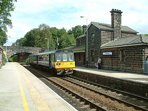
Delamere 
Location Place Delamere Local authority Cheshire West and Chester Operations Station code DLM Managed by Northern Rail Number of platforms 2 Live arrivals/departures and station information
from National Rail EnquiriesAnnual rail passenger usage 2004/05 * 15,252 2005/06 *  16,736
2006/07 * 20,9962007/08 * 28,2202008/09 * 29,8702009/10 * 34,500National Rail - UK railway stations A B C D E F G H I J K L M N O P Q R S T U V W X Y Z * Annual passenger usage based on sales of tickets in stated financial year(s) which end or originate at Delamere from Office of Rail Regulation statistics. Please note: methodology may vary year on year. Delamere railway station opened on 22 June 1870. It serves both the village of Delamere and Delamere Forest in Cheshire, England. The station is 15 km (9½ miles) east of Chester on the Mid-Cheshire Line.
The station was, until 12th December 2010, a request stop only. It is unmanned, thus one must board the train and present a valid ticket or pay the fare, railcard fares are accepted.
The station marks one end of the Baker Way footpath.
The station was used as a location in an episode of the popular UK TV series 'Survivors'. It is also used in the opening scenes of Nickelodeons new series. The House os Abubis.
Services
- The station gets 1tph to Chester stopping at:
- Mouldsworth and Chester
- There is also 1tph to Manchester Piccadilly , which stops at:
- Cuddington, Greenbank, Northwich, Lostock Gralam, Plumley, Knutsford, Mobberley (on request), Ashley (on request), Hale, Altrincham, Navigation Road, Stockport and Manchester Piccadilly.
- The Sunday service is two-hourly in each direction, with eastbound trains now running through to Bolton and Southport via Manchester Piccadilly.
External links
- Train times and station information for Delamere railway station from National Rail
- Mid-Cheshire Community Rail Partnership
Preceding station  National Rail
Following station Mouldsworth Northern Rail
(Mid-Cheshire Line)Cuddington Railway stations in Cheshire West Coast Main Line Crewe to Manchester Line Styal Line Crewe to Derby Line Stoke to Manchester Line Buxton Line Mid-Cheshire Line Ashley • Mobberley • Knutsford • Plumley • Lostock Gralam • Northwich • Greenbank • Cuddington • Delamere • Mouldsworth • ChesterManchester to Liverpool Line Ellesmere Port to Warrington Line Wirral Line Welsh Marches Line Borderlands Line Shrewsbury to Chester Line Chester • Lache (proposed)Coordinates: 53°13′44″N 2°40′01″W / 53.229°N 2.667°W
Categories:- Railway stations in Cheshire
- Former Cheshire Lines Committee stations
- Railway stations served by Northern Rail
- DfT Category F1 stations
- British railway request stops
- North West England railway station stubs

Wikimedia Foundation. 2010.