Murrin Provincial Park

Murrin Provincial Park
IUCN Category II (National Park)
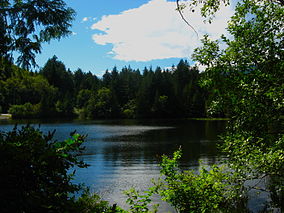
Murrin PP.JPG
Browning Lake, summer 2010
Location British Columbia, Canada
Nearest city Squamish
Coordinates 49°38′40″N 123°12′30″W / 49.64444°N 123.20833°W / 49.64444; -123.20833Coordinates: 49°38′40″N 123°12′30″W / 49.64444°N 123.20833°W / 49.64444; -123.20833[1]
Area 24 hectares (59 acres)[2]
Established May 1, 1962 (1962-05-01)[1]
Governing body BC Parks
Official website

Murrin Provincial Park is a provincial park in British Columbia, Canada, located just south of Squamish beside the Sea-to-Sky Highway. The park is approximately 24 ha. in size and has a popular highway-side picnic ground and small swimming lake (Browning Lake), but it is most notable for a collection of petroglyphs located away from the highway and accessed by trail. Several rockfaces in the area of the park are popular with the local mountain-climbing community, though the site is nowhere as busy as the nearby Stawamus Chief.

Other provincial parks nearby are Stawamus Chief Provincial Park, Shannon Falls Provincial Park and Porteau Cove Provincial Park.

References


Wikimedia Foundation. 2010.

Игры ⚽ Нужен реферат?

Look at other dictionaries:

  • Shannon Falls Provincial Park — IUCN Kategorie III …   Deutsch Wikipedia

  • Shannon Falls Provincial Park — is a provincial park in British Columbia, Canada. It is located km to mi|58 from Vancouver and km to mi|2 south of Squamish along the Sea to Sky Highway. The park covers an area of 87 hectares. The main point of interest is the third highest… …   Wikipedia

  • Cypress Provincial Park — IUCN Category II (National Park) …   Wikipedia

  • Clendinning Provincial Park — is a provincial park in British Columbia, Canada.[1] It surrounds the drainage of Clendinning Creek, which is a tributary of the Elaho River. Its name is shared by the Clendinning Range, of which Mount Clendinning is the highest summit (there is… …   Wikipedia

  • Mount Seymour Provincial Park — Mount Seymour Provincial Park. September, 2005 East slopes, looking north toward Mt. Elsay …   Wikipedia

  • Nairn Falls Provincial Park — Location of Nairn Falls Provincial Park in British Columbia Location British Columbia, Canada …   Wikipedia

  • Mount Elphinstone Provincial Park — is a provincial park in British Columbia, Canada, located around the mountain of the same name on the west side of Howe Sound, just north of the town of Gibsons and just above the community of Roberts Creek. Created in 2000 the park is… …   Wikipedia

  • Davis Lake Provincial Park — is a provincial park in British Columbia, Canada. It is located east of the southern end of Stave Lake,[1][2] northeast of Mission, British Columbia. The park s area is c. 185 acres (0.75 km2). There are campgrounds and beaches at the south… …   Wikipedia

  • Duffey Lake Provincial Park — is a provincial park in British Columbia, Canada, located at the lake of the same name, which lies along BC Highway 99 just east of the summit of Cayoosh Pass. The lake s inflow and outflow are Cayoosh Creek. References …   Wikipedia

  • Mehatl Creek Provincial Park — is a provincial park in British Columbia, Canada, located in the central Lillooet Ranges to the west of Boston Bar. References BC Parks webpage Mehatl Creek Park . BC Geographical Names. http://apps.gov.bc.ca/pub/bcgnws/names/51426.html …   Wikipedia

Share the article and excerpts

Direct link
Do a right-click on the link above
and select “Copy Link”