Mississippi River System

Mississippi River System

The Mississippi River System, also referred to as the Western Rivers, is a mostly riverine network which includes the Mississippi River and connecting waterways.


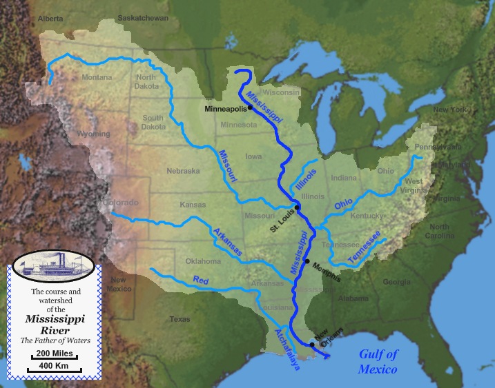
Map of the course, watershed, and major tributaries of the Mississippi River

From the perspective of natural geography and hydrology, the system consists of the Mississippi River itself and its numerous natural tributaries and distributaries. The major tributaries are the Ohio, Illinois, Arkansas, Red and Missouri Rivers and, indirectly, such major Ohio River tributaries as the Allegheny, Tennessee, and Wabash rivers. [1]

From the perspective of modern commercial navigation, the system includes the above as well as navigable inland waterways which are connected by artificial means. Important connecting waterways include the Illinois Waterway, the Tennessee-Tombigbee Waterway, and the Gulf Intracoastal Waterway. This system of waterways is maintained by the U.S. Army Corps of Engineers with a project depth of between 9 and 12 feet (2.7 – 3.7 m) to accommodate barge transportation, primarily of bulk commodities. [2]

Notes

  1. ^ "Mississippi River". USGS Biological Resources. Archived from the original on 2005-10-28. http://web.archive.org/web/20051028140409/http://biology.usgs.gov/s+t/SNT/noframe/ms137.htm. Retrieved 2006-03-08. 
  2. ^ "The Mississippi River System". US Army Corps of Engineers. http://www.mvn.usace.army.mil/pao/history/MISSRNAV/river.asp. Retrieved 2006-03-08. 


Coordinates: 47°14′23″N 95°12′27″W / 47.23972°N 95.2075°W / 47.23972; -95.2075


Wikimedia Foundation. 2010.

Игры ⚽ Нужна курсовая?

Look at other dictionaries:

  • Mississippi River — For the river in Canada, see Mississippi River (Ontario). Coordinates: 29°09′04″N 89°15′12″W / 29.15111°N 89.25333°W / …   Wikipedia

  • Mississippi River — Mississippi Der Mississippi bei New OrleansVorlage:Infobox Fluss/KARTE fehlt Daten …   Deutsch Wikipedia

  • Mississippi River Watershed Conservation Programs — Mississippi River Watershed ‎ Conservation programs for the Mississippi River watershed are designed to protect and preserve the Mississippi River and the surrounding area by implementing practices that decrease the harmful effects on habitats… …   Wikipedia

  • Mississippi River — a major river of North America that flows from the US state of Minnesota to the Gulf of Mexico. It was called the ‘Father of Waters’ by Native Americans. It is 2 348 miles/3 778 kilometres long and passes the cities of Minneapolis, St Louis,… …   Universalium

  • Upper Mississippi River — Infobox River | river name = Upper Mississippi River caption = The Upper Mississippi River near Harpers Ferry, Iowa origin = Lake Itasca, Minnesota coord|47.253|N|95.212|W| mouth = Cairo, Illinois (flows into Lower Mississippi River)… …   Wikipedia

  • Lower Mississippi River — Infobox River | river name = Lower Mississippi River caption = The Lower Mississippi River Towboats, barges and ships near New Orleans. origin = Cairo, Illinois (confluence of Ohio River and Upper Mississippi River) mouth = Gulf of Mexico basin… …   Wikipedia

  • I-35W Mississippi River bridge — This article is about the bridge that collapsed in 2007. For the replacement bridge, see I 35W Saint Anthony Falls Bridge. Mississippi River Bridge …   Wikipedia

  • 2011 Mississippi River floods — The Great 2011 Mississippi River floods 100 populated locations were experiencing major or moderate flooding on May 8, 2011. Source: National Weather Service …   Wikipedia

  • Elk River (Mississippi River, Minnesota) — Elk River Elk River im Benton County (2004)Vorlage:Infobox Fluss/KARTE fehlt Daten …   Deutsch Wikipedia

  • New Mississippi River Bridge — Official name Not named yet [1] Carries 4 lanes of I 70, expandable to 6[ …   Wikipedia

Share the article and excerpts

Direct link
Do a right-click on the link above
and select “Copy Link”