- Dharmapuri district
-
This article is about the district. For its eponymous headquarters, see Dharmapuri.
Dharmapuri District
தருமபுரி(தர்மபுரி) மாவட்டம்
— district — Hogenakkal Waterfalls in Dharmapuri district
Coordinates 12°7′33.6″N 78°9′14.4″E / 12.126°N 78.154°ECoordinates: 12°7′33.6″N 78°9′14.4″E / 12.126°N 78.154°E Country India State Tamil Nadu Subdistrict(s) Dharmapuri, Harur, Palakcode, Pappireddipatti, Pennagaram. Headquarters Dharmapuri Largest city Dharmapuri Largest metro Dharmapuri Collector R. Lilly, IAS Superintendent of Police Amit Kumar Singh, IPS Municipal Corporations Dharmapuri Municipalities Town Panchayats Official languages Tamil Time zone IST (UTC+05:30) Central location: 12°7′N 78°9′E / 12.117°N 78.15°E Website Official website of Dharmapuri District Dharmapuri District (Tamil: தருமபுரி(தர்மபுரி) மாவட்டம்) is a district in Tamil Nadu state in southern India. The district came into existence from October 10, 1965. Dharmapuri is the district headquarters. Dharmapuri town is historically called "Thakadoor".
Contents
Geography
The district is located between latitudes N 11 47’ and 12 33’ and longitudes E 77 02’ and 78 40’. Occupies an area of 4497.77 km²(i.e. 3.46% of Tamil Nadu) and has a population of 2,856,300 (as of 2001). It is bounded on the north by Krishnagiri District, on the east by Tiruvannamalai District and Viluppuram District districts, on the south by Salem District, and on the west by Karnataka's Chamarajanagar District.The Whole district is surrounded by hills and forests.
History
The earliest known chieftain who ruled Tagadur (present Dharmapuri) during the Sangam era, is Adigaman Naduman Anji, whose patronage sustained the famous poetess Avvaiyar. The next we hear in the 8th century when the northern parts of Salem District were probably under the Pallavas regime. Subsequently, we hear of the Ganga Pallavas having sway over the Western parts of the Salem District. The Western Gangas are also mentioned as having ruled Baramahal during the end of the 8th century.
In the beginning of the 9th Century, the Rashtrakutas gained power and influenced the history of the district for the next two centuries. During the period, the Cholas also rose to power in the south and Aditya-I conquered the Kongunadu in 894 A.D. During 949-950 A.D., the Cholas suffered a defeat from the Rastrakuttas whose decline started later after the death of their king Krishna-III. Subsequently, the entire area in Salem District came under the rule of the Cholas. The Gangavadi was then annexed to the Chola territory and placed in charge of an Adigaman Tagadur. The 12th century witnessed the decline of the Chola empire when the Hoysalas rose to power and routed the Cholas from Gangavadi. They are said to have captured Kolar, sacked Kotayur and over ran the western parts of Kongunadu. The Baramahal and Talaget areas apparently still remained with the Cholas. But the Adigaman seems to have practically become free and owed only nominal allegiance to the Cholas. Soundrapandia-I assisted the Yadavas in driving out the Hoysala king, Vira Someswara from the Chola territory.
The history of the 13th Century revolve itself between the Hoysalas and the Pandyas. This portion may be added after when they were attacked from the North by the Yadavas, the Hoysalas retreated towards the South in Kongunadu. It is known that Jatavarman Soundrapandian-I assisted the Yadavas in driving out the Hoysalas king, Vira Someswara, from the Chola territory. But it is doubtful whether he made himself master of the Talaghat area as there are records to show that Vira Someswara's son Vira Ramanatha later ruled the whole of Salem District and the Pandiyas were then eclipsed by the Mohammadan emissaries of the Delhi Sultanate.
The rise of Vijayanagar kingdom was seen in the 14th century. In 1365-66 A.D., Bukka-I turned his attention towards the south to overthrow the Mohammedan Sultanate of Madurai. One of these campaigns must have brought Salem District under the Vijayanagar kings. They ruled these parts till 1565 A.D when the glory of the Vijayanagar king was laid in dust by the combined armies of the Deccan Sultans on the field at Talikota Hosur Denkanikota. While Jagaderea Raya of Chennapatna ruled the Baramahal along with Mysore. Meanwhile the ascendancy of the Madurai Nayakas reached its zenith during the time of Tirumala Nayak who came to power in 1623 A.D. and this tract was placed in charge of Poligars owing allegiance to him. Ramachandra Nayaka, one of his poligars was incharge of Talaimalai a hill overlooking the Cauvery in the south Namakkal taluk. The Namakkal Fort is said to have been built by them. The Gathi Mudaliars were incharge of the most dangerously exposed province of the Nayak Kingdom with Kaveripuram on the right bank of the Cauvery as their strategic capital commencing one of the principal passes to the Mysore plateau. The centre of then power seems, however to have been Taramangalam where they built a grand edifice of a temple. It is said that their domination extended as far as Talaivasal to the east, Dharapuram in Coimbatore District in the south. The forts of greatest strategic importance held by the Gathi Mudaliars were Omalur and Attur.
Several places in Coimbatore were taken by Kantirave Narasa Raja of Srirangapatinam from Gathi Mudaliars in 1611 A.D. After 11 years, he seized Baramahal including Viralahadradurg, Pennagaram, Dharmapuri and Denkanikotta in 1654 A.D., he took over Hosur from Chandra Sankar Dodda Devaraju the king of Mysore wrested Omalur from the Gathi Mudaliars and thus erased them out of political scene. The aggression of Marattas, however checked the power of the Mysore Kings. For a time Baramahal and Talaghat passed into the hands of Marattas. In 1688-89 A.D., Chikka Deva Raya king of Mysore felt strong enough once again to invade Baramahal and wrested Dharmapuri, Manukonda, Omalur Paramathi, Kaveripatinam and Attur were also retrieved by Chika Deva Raya and the whole district of Salem came under his control before his death in 1704 A.D. Meanwhile Abdul Nabikhan of Nawab of Cuddapah extended his possession towards South and by 1714 A.D., he made himself master of the Baramahal.
By about 1750 A.D., Hyder Ali was in power in Mysore Baramahal came under his sway in 1760 A.D. By 1767 A.D., the British Government at Madras planned an attack on Hyder Ali and seized Kaveripattinam without serious opposition. Krishnagiri was then besieged. Meanwhile, reinforcement was brought by Hyder Ali and they drove away the British. Thus, Kaveripattinam was recaptured. Some months later the British made another invasion on the Baramahal. Further, South Dharmapuri, Salem, Attur, Sendamangalam and Namakkal were surrendered to the British without serious difficulties. The victory, however, was short-lived because Hyder Ali soon recaptured Dharmapuri, Denkanikota, Omalur, Salem and Namakkal. During the period of second Mysore war, Salem District was in the hands of Hyder Ali.
Tippu Sultan succeeded Hyder Ali and proved to be a formidable power. The British made an alliance with the Marattas and the Nizam and started the third Mysore war in 1790 A.D., in order to curb the power of Tippu Sultan. A wing of the British forces stationed itself fully reinforced at Kaveripattinam. Even though Tippu Sultan rushed to this spot with his full force, he could not dislodge the British. A number of alternations took place between the commanding forces in the Baramahal area. In 1791, Hosur, Anjetti, Nilgiri and Ratnagiri came under the British Royakotta and many other small forts fell without much resistance. In 1791 Tippu sent a force from the South along the Tippu pass. In the battle at Pennagaram they surrendered to the British. In 1792 A.D., a peace treaty was signed between Tippu and English. According to this, a half of the dominion of Tippu was taken away. The whole of Salem District except the Balaghat and a portion of Hosur came into the hands of the British. The first British Collector had is headquarters at Krishnagiri on strategic consideration.
The last Mysore war in 1799 added up several places in Hosur Taluk like Nilgiri, Anjetti, Durgam, Ratnagiri and Kelamangalam which were recaptured by British. After the fall of Srirangapattinam in which Tippu Sultan lost his life, the Balaghat area was also added to Salem District.
The present Dharmapuri district was then a part of the Salem district. During the British rule in the country and even till 1947 Dharmapuri was one of the Taluks of Salem District. The Dharmapuri district was formed as a separate district on 02/10/1965 with its headquarters at Dharmapuri.
Thiru G.Thirumal I.A.S was the first Collector of Dharmapuri district.
The Dharmapuri district was bifurcated into Dharmapuri and Krishnagiri districts on 09/02/2004.
District Administration
District Administration is headed by the District Collector. Present District Collector is R.Lilli, I.A.S.
Divisions
Revenue division: Dharmapuri and Harur.
Revenue taluks: Dharmapuri, Palacode, Pennagaram, Harur and Pappireddipatti.
Town Panchayats: Marandahalli, Bommidi, Palacode, Pennagaram, Karimanagalam, Kambainallur, Harur, Papparapatti, Kadathur, Pappireddipatti.
Panchayat Unions: Dharmapuri, Nallampalli, Palacode, Pennagaram, Karimanagalam, Morappur, Harur, Pappireddipatti.
Language and Culture
The inhabitants of the District speak different languages. The predominant communities found in this area are the Kapus, Lingayaths, Okkaligas, Baliya Chetties, Oddars and Scheduled Castes like Holeyas and Madigas. The weavers of this area mostly belong to Sali Chetties.The Baramahal area comprising eastern part of the Dharmapuri taluk constitutes Telugu and Tamil speaking communities, majority of whom belong to Vanniars,The Malayali tribe is inhabited in the Chitheri Hills areas. Among the Scheduled Caste population Adi-Dravidars and Arunthathiars form major share who scattered throughout the district.
Climate and Rainfall
The climate of the Dharmapuri District is generally warm. The hottest period of the year is generally from the months of March to May, the highest temperature going up to 38 C in April. The Climate becomes cool in December and continuous so up to February, touching a minimum of 17 C in January. On an average the District receives an annual rainfall of 895.56 mm.
Soil
The Soil type ranges from black to mixed loam; Red sandy soils are seen in Harur Taluk. Black and loam soil are found in Dharmapuri Taluk. Generally the soil is low in Nitrogen and Phosphate content with no marked variation between Taluks.
Horticulture
Dharmapuri district forms a major horticultural belt in the state. As the area is drought – prone it has become essential to switch over to cultivation of drought tolerant perennial fruit crops in this district. Mango is the main horticulture crop of this District. It has the highest area under the fruit crops . The district accounts for nearly one-third area under mango and nearly one-half of the mango yield in the state. Palacode is the main area where tomato is cultivated. Chilli is cultivated mainly at Pennagaram.
Fisheries
Dharmapuri being an inland district, fishing is restricted to inland only here. Main varieties of fish available are katla, rogu, mirgal, common and corp.
Mineral Resources
Dharmapuri district is endowed with sizeable reserves of granite. High quality black granite is available in Pennagaram, Harur and Palacode blocks. Quartz is available at Kendiganapalli Village of Pennagaram Taluk, A. Velampatti of Harur taluk and Pethathampatti of Pappireddipatti Taluk. Another High value mineral available here is Malibdinum, which is identified as a good conductor. It is available in Harur.
Demographics
According to the 2011 census Dharmapuri district has a population of 1,502,900,[2] roughly equal to the nation of Gabon[3] or the US state of Hawaii.[4] This gives it a ranking of 334th in India (out of a total of 640).[2] The district has a population density of 332 inhabitants per square kilometre (860 /sq mi) .[2] Its population growth rate over the decade 2001-2011 was 16.04 %.[2] Dharmapuri has a sex ratio of 946 females for every 1000 males,[2] and a literacy rate of 64.71 %.[2]
Tourism
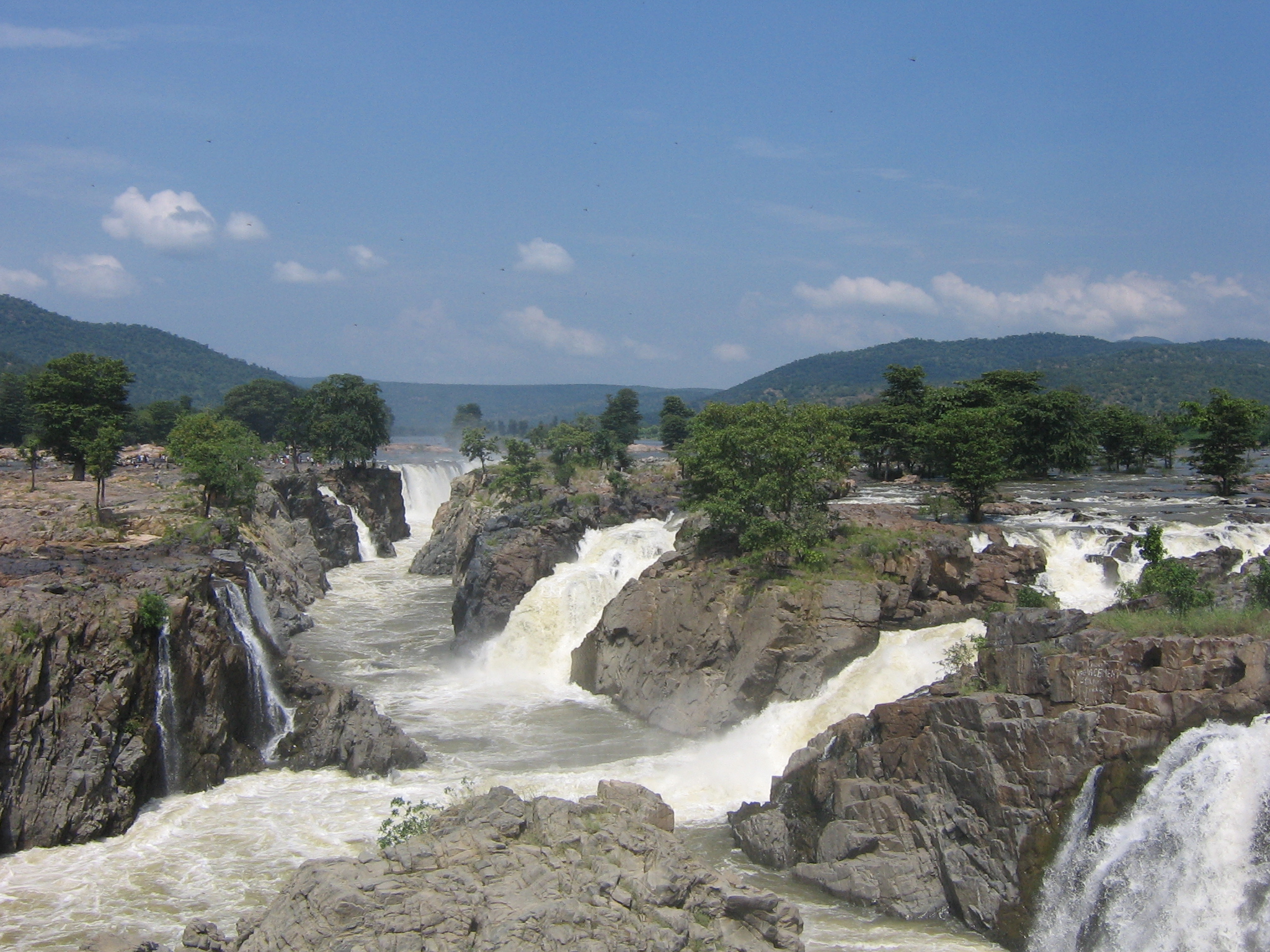
Dharmapuri district's main tourist attraction is Hogenekkal Water Falls. Other attractions are Theerthamalai Temple, Adiyaman Kottam, Thenkaraikottai, Subramaniya Siva Memorial, Sir Thomas Munro Pillar.
Hogenekkal Water Falls
Hogenakal is situated at the borders of Karnataka at 46 km from Dharmapuri. In Hogenakal the river Cauvery enters into Tamil Nadu as a big river with gushing water presentably as a natural falls. The name Hogenakal is derived from Kannada means 'Smoky Rocks'. The river when falls on the rock below, the gushing force of water resembles like smoke emanating from the rocks. At Hogenakal the water spreads for miles around and on these waters cruising on country made dinghies (PARISAL) is possible. Parisal ride will give an enthralling experience. Surrounding by hills at various heights Hogenakal offers the visitors a different ambience and refreshing relaxations. One could also take bath in the falls. Oil massaging by local people is a different experience. As the river flows throughout the year Hogenakal can be visited all days through the year. There are enough transport facility available from Dharmapuri & Krishnagiri.
Theerthamalai Temple
Theerthamalai is an important sacred place in Harur taluk of Dharmapuri District. Shri Theerthagirishwarar Temple is located at the top of a hillock. Chola and Vijayanagara Kings donated liberally to this temple. A lot of devotees throng the temple during the Mahashivarathiri. The Department of Tourism has a Guest Houses for the benefit of the devotees. Theerthamalai is declared as an important tourist spot in Dharmapuri District.
Adhiyamankottai
The capital of Adhiyamans, ancient rulers of Tagadur, was Adhiyamankottai which is situated on the Salem-Dharmapuri road at a distance of 7 km from Dharmapuri. The ruins of the roughly oval shaped fort is still there. The Chenraya Perumal temple is the biggest of the lot which is held as a protected monument which is believed to have been constructed both by the King Krishna Deva Raya and Hoysala Kings. There is a mandapam which leads to the sanctum sanctorium. There are paintings in the ceiling depicting scenes from the Mahabaratham, Viswarupa dharshan of Lord Krishna and some scenes from Ramayana and is still pleasing to the eye. All the paintings are belonging to 13 century.
Subramanya Siva Memorial –Pauparapatti
A monument built in memory of the great patriot Subramanya Siva in his samadhi at Papparapatti, Pennagaram Taluk.
Sir Thomas Munro Pillar at Dharmapuri
This pillar was erected by the government of Madras to mark the association of Dharmapuri with SIR THOMAS MUNRO who lived here from April 1792 to March 1799 as Assistant to the Superintendent of Revenue in the BARAMAHAL. His house and his favourite garden where few yards away from this place.
Places of Worship
- Vediyappan Temple, Adhikarapatti.
- C.S.I. Zion Church, Dharmapuri.
- Sacred Heart Cathedral,Near bus stand, Dharmapuri.
- Malligarjuna Swamy Temple, Dharmapuri.
- Paravasudevar Kovil, Dharmapuri.
- Theerthagiri Easwarar Temple, Theerthamalai.
- Hariharanathar Kovil, Dharmapuri.
- Raghavendra Swami Temple, Bharathipuram.
- Chennammal Koil, T. Ammapet.
- Singarathoppu Muniappan Koil, Morappur.
- Kollapuriamman Temple, Thippampatti.
- Venkataramanasami Temple, Mukkulam.
- Anjenayar Kovil, V. Muthampatti.
- Chenrayasamy Temple, Adiyaman Kottai.
- Kallur Vediappan temple,Sekkampatti (2 km From Harur)
- MarakaChelliamman Temple, Tamaleripatti.
- Mariamman Temple, Adikarapatti.
- Arasar Kottai, Thenkaraikottai.
- Salai Vinikayer Kovil, Dharmapuri.
- Radhakrishna Swamy Temple, Aatukarampatti.
- Bairavar kovil-Adhiyamankottai.
- Akkumariyamman Kovil, Sompalli.
- Mount Carmel Church, B.Pallipatti.
- Muniappan Swami Kovil, Palavadi.
- Thiru Vediappaswamy Thiru Kovil, Harur.
- Hazrath Syed Shah Vali Ulla Dragha
- Masjid-e- Azam, Palacode
- Madina Masjid, Palacode
- Jumma Masjid, Palacode
- Johar Masjid, Palacode
- Ashrafia Masjid, Palacode
- Sunnath Jamia Masjid, Palacode
- kaaniamman temple, Irulapatti
- End Time Zion Church, Dharmapuri
References
- ^ www.tn.gov.in
- ^ a b c d e f "District Census 2011". Census2011.co.in. 2011. http://www.census2011.co.in/district.php. Retrieved 2011-09-30.
- ^ US Directorate of Intelligence. "Country Comparison:Population". https://www.cia.gov/library/publications/the-world-factbook/rankorder/2119rank.html. Retrieved 2011-10-01. "Gabon 1,576,665"
- ^ "2010 Resident Population Data". U. S. Census Bureau. http://2010.census.gov/2010census/data/apportionment-pop-text.php. Retrieved 2011-09-30. "Hawaii 1,360,301"
External links

Krishnagiri district Tiruvannamalai district Chamarajanagar district, Karnataka 
 Dharmapuri district

Erode district Salem district Viluppuram district Dharmapuri district District Headquarters Dharmapuri
State Region Taluks Dharmapuri · Harur · Palacode · Pappireddipatti · Pennagaram
Blocks Dharmapuri · Harur · Karimangalam · Morappur · Nallampalli · Palakcode · Pappireddipatti · Pennagaram
Town panchayats Harur · Kadathur · Kariamangalam · Marandahalli · Palakkodu · Papparapatti · Pappireddipatti · Pennagaram · B. Mallapuram · Kambainallur ·
Places of interest Cities and towns · People · Villages
Categories:- Dharmapuri District
- Districts of Tamil Nadu
- 1965 establishments


Wikimedia Foundation. 2010.