- Northeast Kingdom
-
The Northeast Kingdom is a term used to describe the northeast corner of the U.S. state of Vermont, comprising Essex, Orleans and Caledonia Counties and having a population of 62,438. In Vermont, the written term "NEK" is often used. The term is attributed to the late George D. Aiken, former Governor of Vermont and a U.S. Senator at the time of a 1949 speech, the first recorded use of the term. The area is often referred to by Vermonters simply as "The Kingdom."
 Panoramic view of Willoughby Notch and Mount Pisgah.
Contents
Geography
The Northeast Kingdom is bisected by Interstate 91/U.S. 5. On the east it is bordered by the Connecticut River. The highest point is Jay Peak at 3,858 feet (1,176 m).[1]
The Kingdom encompasses 55 towns and gores, with a land area of 2,027 square miles (5,250 km2), about 21% of the state of Vermont.[2] The city of Newport is the single incorporated city in the tri-county area.
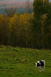
The area is a year-round recreation destination known for skiing, fall foliage viewing, and production of maple syrup .
As of 1997, 80% of the Northeast Kingdom was covered by forest.[3] 59% was northern hardwood, 29% spruce or fir.
The Northeast Kingdom has been listed in the North American and international editions of "1,000 Places to See Before You Die", the New York Times best-selling book by Patricia Schultz. In 2006, the National Geographic Society named the Northeast Kingdom as the most desirable place to visit in the country and the ninth most desirable place to visit in the world.[4]
Geology
The presence of Kame terraces in the counties are of interest in connection with the drift that gave the Northeast Kingdom its soil, and its surface stones and boulders. These terraces have beds of sand and clay from which bricks were once manufactured.[5]
Fauna
 .
.In 1996, the moose population totalled 2,000, about 1.75/mi² (0.676/km²). In 2005, the population was 5,000; 3.4/mi² (1.313/km²). State officials determined that the herd had become stressed due to overpopulation, and that the 1996 figure was more desirable. As a result, 1,260 hunting permits were issued in 2008 to cull the herd.[6] In 2009, state officials aimed for 1 moose per 1 square mile (2.6 km2).[7]
There are also black bear, deer, bobcat, coyote, fox, fisher cat, loon, wild turkey, and ruffed grouse.
Climate
The average growing season is about 123-130 frost-free days.[8]
On December 30, 1933 the lowest recorded temperature in the New England states was registered as -50.8 °F (-46 °C), at Bloomfield in Essex County.[9][10]
The 2007 Valentine's Day Blizzard brought 21.1 inches (540 mm) to the area over a two day period. This was nearly matched on March 6, 2011, when the area received 20.3 inches (520 mm) of snow.[11]
Government
As in the rest of New England, there is a strong state government. Town government often uses unpaid volunteers for its services. There is a superficial county government, all funded by the state. The three-county area each have sheriffs, judges, prosecutors, and other officers, all, except for judges, elected by the county, but funded by the state.
Recognizing the need for services on an intermediate level, the legislation created the Regional Planning Commissions (RPC), to aid the towns in land use issues and Economic Development Commissions (EDC), tasked with fostering economic development in their jurisdictions. These RPCs and EDCs report to the Vermont Agency of Commerce and Community Development they must also report to their boards, which are made up of representatives of each town in the commission. As with some state agencies there is provision for these commissions to also organize as nonprofit groups, yet still maintain status as government agencies. This method of organization permits RPCs and EDCs to augment their state and federal funding with other sources of income. This arrangement also allows the EDCs to own properties such as Industrial Parks and Business Incubator Facilities.
RPCs and EDCs have no taxing or regulatory authority. However RPCs do write a regional plan (as towns can have town plans.) Town plans can not run contrary to the regional plans. RPCs also have automatic party status to any ACT 250 applications. ACT 250 permits are the State’s Land Use Permit issued by the Land Use Panel of the Vermont Natural Resources Board. ACT 250 applications must be in compliance with the RPC’s Regional Plan. A copy of all ACT 250 permit applications must be submitted (by the applicants) to the RPCs for review.
The Northeast Kingdom is unique, as they have the only agency that is both the Economic Development Commission as well as the Regional Planning Commission, known as the Northeastern Vermont Development Association and Regional Planning Commission (NVDA). Under the legislators’ study to lower State spending, they have been looking to the Northeast Kingdom’s RPC/EDC as a model for possible consolidation of agencies throughout the state.
Municipalities are governed by an elected Board of Selectmen and managed by an elected town or city clerk.
Public health
Various organizations are tasked with aiding public health including the Northeast Kingdom Human Services.
Economy
Farming
In 2010 the largest dairy farmer in the state was in Orleans County with 5,000 head and 2,500 milkers, spread over 5 farms.[12]
NGOs
There are a number of non-profit, non-governmental agencies, that either offer services or promote business or housing. These include The Northern Community Investment Corporation, based in St. Johnsbury, and the Gilman Housing Trust.[13]
Transportation
 .
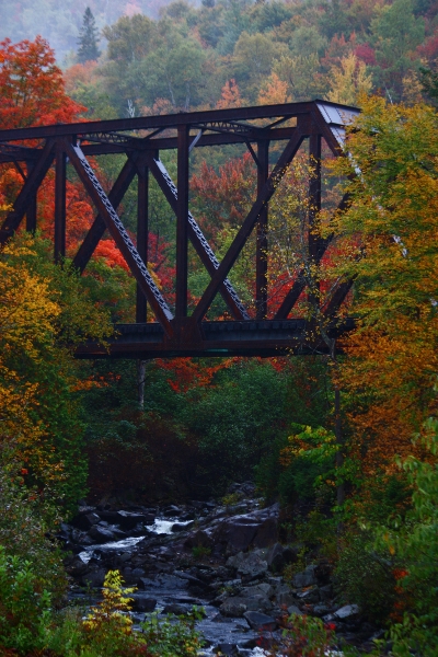
. The "Iron Bridge" in Brighton, just north of the village of Island Pond
In 2008, 74% of the roads were rated in poor or very poor condition. There were 480 bridges with spans of 20 feet or more. There were a number of bridges deemed structurally deficient. Sixty-three percent of those were municipally owned.[14]
Railroads
Two railroads traverse the Northeast Kingdom of Vermont:
Washington County Railroad (The Vermont Railway System) - WACR has just recently been awarded a 30 year contract to operate the track running from White River Junction North through St. Johnsbury and Newport.
The St. Lawrence and Atlantic Railroad - Six trips a day between Island Pond and Maine. Four trips a day between Island Pond and Canada. Lumber is the principal freight.[15]
Bus
Rural Community Transportation runs out of Saint Johnsbury and services Caledonia, Essex, Lamoille and Orleans Counties.
Airports
There are three state airports: Caledonia County State Airport in Lyndonville; Newport State Airport in Newport/Coventry and John H. Boylan State Airport in Island Pond. Light private and business aircraft land there.
History
Geologic
Two land masses collided at the end of the Ordovician Period about 466 million years ago. This collision first formed what are now the Green Mountains which extend into the westernmost part of the Northeast Kingdom.[16] It also created great pressure within the earth resulting in active volcanoes. The resultant eruptions produced igneous rock which became the granite often seen near the mountains and in the Connecticut River Valley.[17]
The remaining geology was created during the Silurian-Devonian Period, about 400 million years ago, and left behind slate, with some granite, schist, and limestone.[18][19]
An expansion of the polar glaciers resulted in an ice age which greatly affected the geology. A 1 mile (1.6 km) thick sheet of ice covered the Kingdom several times, over one million years, until 13,500 years ago.[20] It brought the many boulders seen in the area and created many prominent features, including Lakes Memphremagog, Willoughby, and Crystal Lake.[21]
The retreat of the Laurentide glacier allowed the Green Mountains again to arise, but much eroded.[22] A saltwater incursion resulting in the Champlain Sea from the Atlantic Ocean covered much of Vermont including what is now Lake Memphremagog. This incursion stopped 11,000 years ago and became fresh water. Forests later appeared after the water receded.
Early human history
The retreating glacier allowed the northern migration of early humans in 9300 BCE, descendants of Asian immigrants during the Ice Age. By 7300 BCE, people and a changing environment had eliminated large game from the area such as caribou and mastodons.[23]
From 1000 BCE to 1600 CE, Abenakis inhabited the Kingdom.[23]
Perhaps as many as a thousand Cowasuck Indians lived in Essex County near the Connecticut River in 1500. This tribe included all people from the Cahass, Cohassiac, Coos, Coosuc, and Koes tribes.[24] The Cowasucks were Abenakis, themselves members of the Wabanakis, the Algonquian pact of five tribes which banded together to combat Iroquois aggression perhaps about 1500, though the exact date of the Iroquois pact is unknown.[25][26]
European diseases, such as typhus, contracted from exposure to traders, killed many of the Cowasucks until only a few hundred were left in the Northeast Kingdom by 1600.[27]
Modern history
In 2010, Yankee magazine named the NEK as the second favorite romantic getaway and the third favorite family getaway in New England.[28]
Media
Author Howard Frank Mosher has written works of fiction set in the Northeast Kingdom, typically in the fictitious Kingdom County.
Archer Mayor's second "Joe Gunther" novel, Borderlines, was set in the fictitious village of Gannet, in Essex County.
Peacham, Vermont was used as the filming location for the 1993 movie Ethan Frome based on Edith Wharton's novel of the same name.[29]
Robert Frost wrote a poem with the Kingdom as its topic entitled A Servant to Servants.[30]
Newspapers
- The Caledonian-Record, the area's largest newspaper, is published daily in St. Johnsbury
- The Chronicle - published weekly in Barton
- The Newport Daily Express - published daily except Saturdays and Sundays in Newport. Owned by Horizon Publications out of Marion, IL. Printed in Canada
- The North Star Monthly - published monthly in Danville
- The Hardwick Gazette - published weekly in Hardwick
Radio
- WSTJ - 1340 AM; St. Johnsbury, VT - Standards
- WIKE - 1490 AM; Newport, VT - Country
- WVPA - 88.5 FM; St. Johnsbury, VT - Vermont Public Radio
- WCKJ - 90.5 FM; St. Johnsbury, VT - Religious - "The Light"
- WWLR - 91.5 FM; Lyndonville, VT - Lyndon State College - "Impulse 91.5"
- WMOO - 92.1 FM; Derby Center, VT - Hot Adult Contemporary - "Moo 92"[32]
- WJSY-LP - 96.1 FM; Newport, VT - Religious
- W243AE - 96.5 FM; Orleans, VT - Religious - "The Light"
- WGMT - 97.7 FM; Lyndon, VT - Hot Adult Contemporary - "Magic 97.7"
- WDER-LP - 98.3 FM; Derby, VT - TIS
- W257AU - 99.3 FM; St. Johnsbury, VT - Rebroadcast of WMOO
- WKXH - 105.5 FM; St. Johnsbury, VT - Country - "Kix 105.5"
- WDOT - 95.7 FM; Danville, VT - Adult Album Alternative - "The Point" (rebroadcasts WNCS/Montpelier)
- WVTI 106.9 FM broadcasts classical music from Island Pond, Vermont.[33]
- Radio Free Vermont - Online Radio; East St. Johnsbury, VT - [Vermont Independent Music] - "Radio Free Vermont"[34]
Television
- UHF Channel 20, WVTB (PBS), St. Johnsbury, Vermont Public Television
- Channel 14 W14CK Newport, ion, Rebroadcast of WWBI-LP
- Cable Channel 7, KATV, Kingdom Access Television, Lyndonville, Public-access television cable TV
See also
- Essex-Orleans Vermont Senate District, 2002-2012
References
- ^ Various Vermont Mountains
- ^ [1]
- ^ [2]
- ^ "The National Geographic Society Press Room". Northeast Kingdom Geotourism Mapguide Debuts at Vermont Travel Industry Conference. http://press.nationalgeographic.com/pressroom/index.jsp?pageID=pressReleases_detail&siteID=1&cid=1164733316076. Retrieved 2006-12-22.
- ^ Child, Hamilton. (May 1887). Gazetteer of Lamoille and Orleans Counties, VT.; 1883-1884. Hamilton Child.
- ^ Rathke, Lisa (October 17, 2008). State hopes moose season culls herd. Burlington Free Press.
- ^ Richard Creaser (2009-10-28). "Cow are giving birth to fewer offspring". the chronicle. Chris and Ellen Braithwaite. pp. 13.
- ^ Draft Environmental Assessment retrieved May 28, 2008
- ^ Though this was tied by Black River, Maine in 2009
- ^ Adams, Glenn (February 11, 2009). Maine ties Vt. for record low temperature. Burlington Free Press.
- ^ Starr, Tena (March 9, 2011). "Snowfall brought area to a halt". the Chronicle (Barton, Vermont): pp. 1.
- ^ Page, Candace (20 June 2010). "Potent Alliance". Burlington, Vermont: Burlington Free Press. pp. 1A, 4A.
- ^ The Chronicle, June 3, 2009, page 27, "Economic development debated in Barton". Joseph Cresser
- ^ Creaser, Richard (October 22, 2008). State transportation money is based on traffic. the Chronicle.
- ^ [3]
- ^ "Shelburne Geology". Geologic history of the Champlain Valley. http://www.uvm.edu/shelburnelandscape/nature/geology.html. Retrieved 2006-12-24.
- ^ "Digital Commons - Middlebury". Depth Constraints on the Origins of Northeast Kingdom Granites, Vermont. http://digitalcommons.middlebury.edu/cgi/viewcontent.cgi?article=1002&context=theses. Retrieved 2006-12-28.
- ^ "About Geology". Generalized Geologic Map of Vermont. http://geology.about.com/gi/dynamic/offsite.htm?zi=1/XJ/Ya&sdn=geology&cdn=education&tm=14&gps=79_7_796_432&f=20&su=p284.21.140.ip_&tt=14&bt=0&bts=0&zu=http%3A//www.anr.state.vt.us/dec/geo/images/geo5.JPG. Retrieved 2006-12-24.
- ^ "Geological Society of American Conference". Ordovician Sedimentary Breccia and Magnetite-Coticule Metasiltstone, Northeast Kingdom, Vermont. http://gsa.confex.com/gsa/2001NE/finalprogram/abstract_2396.htm. Retrieved 2006-12-24.
- ^ "The University of Vermont". A Brief History and Overview of Vermont's Physical Landscape. http://www.uvm.edu/place/analyze/history_vt.php. Retrieved 2006-12-24.
- ^ "America's Volcanic Past". Crystal Lake. http://vulcan.wr.usgs.gov/LivingWith/VolcanicPast/Places/volcanic_past_vermont.html. Retrieved 2006-12-24.
- ^ "The Mountains of Vermont". The Green Mountains. http://academics.smcvt.edu/vtgeographic/textbook/mountains/mountains_of_vermont.htm. Retrieved 2006-12-24.
- ^ a b "The Flow of History". Native Americans in Vermont. http://www.flowofhistory.org/themes/movement_settlement/abenaki.php. Retrieved 2006-12-24.
- ^ "First Nations Histories". Abenaki History. http://www.tolatsga.org/aben.html. Retrieved 2006-12-02.
- ^ "Native Languages". Wabanki Confederacy. http://www.native-languages.org/wabanaki.htm. Retrieved 2006-12-24.
- ^ "Native Languages". Iroquois Confederacy. http://www.native-languages.org/iroquois.htm. Retrieved 2006-12-24.
- ^ "Manataka American Indian Council". Abenaki History Part I. http://www.manataka.org/page380.html. Retrieved 2006-12-24.
- ^ "NEK establishments listed in Yankee's best of NE awards". Barton, Vermont: the Chronicle. 3 February 2010. pp. 7. http://www.yankeemagazine.com/issues/2010-01/interact/10things/readers-choice.
- ^ New York Times accessed February 1, 2008
- ^ New York Times retrieved June 29, 2008
- ^ List of Vermont Radio Stations
- ^ MOO 92 retrieved on May 13, 2007
- ^ VPR (October 28, 2008). VPR Classical broadcasts from I.P.. the Chronicle.
- ^ Radio Free Vermont
External links
 State of Vermont
Regions Champlain Valley · Green Mountains · Mount Mansfield · Northeast Kingdom
Counties Addison · Bennington · Caledonia · Chittenden · Essex · Franklin · Grand Isle · Lamoille · Orange · Orleans · Rutland · Washington · Windham · Windsor
Metropolitan areas Burlington-South Burlington metropolitan area
Cities Barre · Burlington · Montpelier · Newport · Rutland · St. Albans · South Burlington · Vergennes · Winooski
Festivals Vermont State Fair · Green Mountain Film Festival
Topics Delegations · Constitution · Culture · Geography · Government · History · Images · People · Politics · Towns · Villages · Visitor Attractions
Categories:- Regions of Vermont
- Vermont culture
- Northeast Kingdom, Vermont


Wikimedia Foundation. 2010.