- Becontree Heath
-
Coordinates: 51°33′49″N 0°09′09″E / 51.563595°N 0.152614°E
Becontree Heath 
 Becontree Heath
Becontree Heath shown within Greater LondonOS grid reference TQ493871 London borough Barking & Dagenham Ceremonial county Greater London Region London Country England Sovereign state United Kingdom Post town DAGENHAM Postcode district RM8 Dialling code 020 Police Metropolitan Fire London Ambulance London EU Parliament London UK Parliament Dagenham and Rainham London Assembly City and East List of places: UK • England • London Becontree Heath (also spelt Beacontree Heath) is an open space in the London Borough of Barking and Dagenham. The name has also been unofficially applied to the local area, in particular to the RM8 postal district.
It is the location, at the corner of Rainham Road North and Wood Lane of Barking and Dagenham Civic Centre, an imposing Grade II listed 1930s art deco building designed by Ernest Berry Webber[1] and the former town hall of Dagenham Borough Council.
Becontree Heath functioned as the ancient meeting place for Becontree hundred, which covered much of what is now East London. In 1465, the hundred lost territory in the east and the meeting place became located on its fringe.[2]
It is the location of a London Buses bus station with services to Chigwell, Canning Town, Romford, Beckton, Dagenham, Rainham, Chadwell Heath and Gallows Corner.[3] Crowlands Heath Golf Club[4] is located here.
Education
- Local education is listed on the London Borough of Barking and Dagenham article.
Gallery
-

Barking and Dagenham Civic Centre.
-

Close up of entrance.
-

Becontree Heath Bus Station.
-

Becontree Heath Bus Station with Barking and Dagenham Civic Centre in background.
References
- ^ Barking and Dagenham London Borough Council - Dagenham Civic Centre
- ^ The hundred of Becontree: Introduction', A History of the County of Essex: Volume 5 (1966). Date accessed: 11 January 2008.
- ^ Transport for London - Becontree Heath (PDF)
- ^ Crowlands Heath Golf Club - Crowlands Heath Golf Club
London Borough of Barking and Dagenham Districts Barking · Becontree · Becontree Heath · Castle Green · Chadwell Heath · Creekmouth · Dagenham · Dagenham Dock · Marks Gate · Rush Green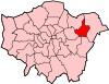
Attractions Barking Abbey · Barking Market · Eastbury Manor House (NT) · Valence House Museum · The Broadway · Victoria RoadParks and open spaces Barking Park · Central Park · Eastbrookend Country Park · Mayesbrook Park · Parsloes Park · Valence ParkConstituencies Tube and rail stations Other topics Parks and open spaces by London borough Barking and Dagenham · Barnet · Bexley · Brent · Bromley · Camden · Croydon · Ealing · Enfield · Greenwich · Hackney · Hammersmith and Fulham · Haringey · Harrow · Havering · Hillingdon · Hounslow · Islington · Kensington and Chelsea · Kingston · Lambeth · Lewisham · Merton · Newham · Redbridge · Richmond · Southwark · Sutton · Tower Hamlets · Waltham Forest · Wandsworth · Westminster
Categories:- Districts of London
- Parks and open spaces in Barking and Dagenham
- Districts of Barking and Dagenham
- London geography stubs


Wikimedia Foundation. 2010.