- National Register of Historic Places listings in Montgomery County, New York
-
 Location of Montgomery County in New York
List of the National Register of Historic Places listings in Montgomery County, New York
This is intended to be a complete list of properties and districts listed on the National Register of Historic Places in Montgomery County, New York. The locations of National Register properties and districts (at least for all showing latitude and longitude coordinates below) may be seen in a Google map by clicking on "Map of all coordinates".[1] Three properties, Fort Johnson, Fort Klock and the Erie Canal aqueduct over Schoharie Creek, are further designated National Historic Landmarks.
-
- This National Park Service list is complete through NPS recent listings posted November 18, 2011.[2]
Contents: Counties in New York Albany (Albany) – Allegany – Bronx – Broome – Cattaraugus – Cayuga – Chautauqua – Chemung – Chenango – Clinton – Columbia – Cortland – Delaware – Dutchess – Erie (Buffalo) – Essex – Franklin – Fulton – Genesee – Greene – Hamilton – Herkimer – Jefferson – Kings (Brooklyn) – Lewis – Livingston – Madison – Monroe (Rochester) – Montgomery – Nassau – New York (Manhattan – Below 14th Street, 14th to 59th Streets, 59th to 110th Streets, Above 110th Street, Islands) – Niagara – Oneida – Onondaga (Syracuse) – Ontario – Orange – Orleans – Oswego – Otsego – Putnam – Queens – Rensselaer – Richmond (Staten Island) – Rockland – Saratoga – Schenectady – Schoharie – Schuyler – Seneca – St. Lawrence – Steuben – Suffolk – Sullivan – Tioga – Tompkins – Ulster – Warren – Washington – Wayne – Westchester (New Rochelle, Peekskill, Yonkers) – Wyoming – Yates Listings county-wide
[3] Landmark name Image Date listed Location City or town Summary 1 Ames Academy Building 
January 24, 2002 611 Latimer Hill Rd.
42°50′13″N 74°36′00″W / 42.836944°N 74.6°WAmes 2 Amsterdam (46th Separate Company) Armory 
July 1, 1994 Jct. of Florida Ave. and Dewitt St., SW corner
42°55′58″N 74°11′59″W / 42.932778°N 74.199722°WAmsterdam 3 Amsterdam City Hall February 5, 2001 61 Church St.
42°56′21″N 74°15′45″W / 42.939167°N 74.2625°WAmsterdam 4 Bates-Englehardt Mansion 
December 7, 1989 19 Washington St.
42°59′59″N 74°40′38″W / 42.999722°N 74.677222°WSt. Johnsville 5 Bragdon-Lipe House October 5, 2005 17 Otsego St.
42°54′14″N 74°34′28″W / 42.903889°N 74.574444°WCanajoharie 6 Walter Butler Homestead June 23, 1976 NE of Fonda on Old Trail Rd.
42°57′43″N 74°21′17″W / 42.961944°N 74.354722°WFonda 7 Caughnawaga Indian Village Site 
August 28, 1973 Address Restricted
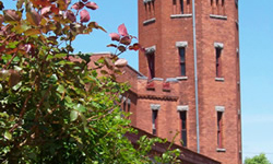
42°57′07″N 74°23′26″W / 42.95181°N 74.390551°WFonda 8 Chalmers Knitting Mills February 22, 2010 21-41 Bridge St.
42°57′07″N 74°23′26″W / 42.95181°N 74.390551°WAmsterdam vicinity 9 Ehle House Site 
June 14, 1982 Address Restricted Nelliston 10 Peter Ehle House September 27, 1980 E. Main St.
42°55′24″N 74°36′05″W / 42.923333°N 74.601389°WNelliston 11 Enlarged Double Lock No. 33 Old Erie Canal April 1, 2002 Towpath Rd.
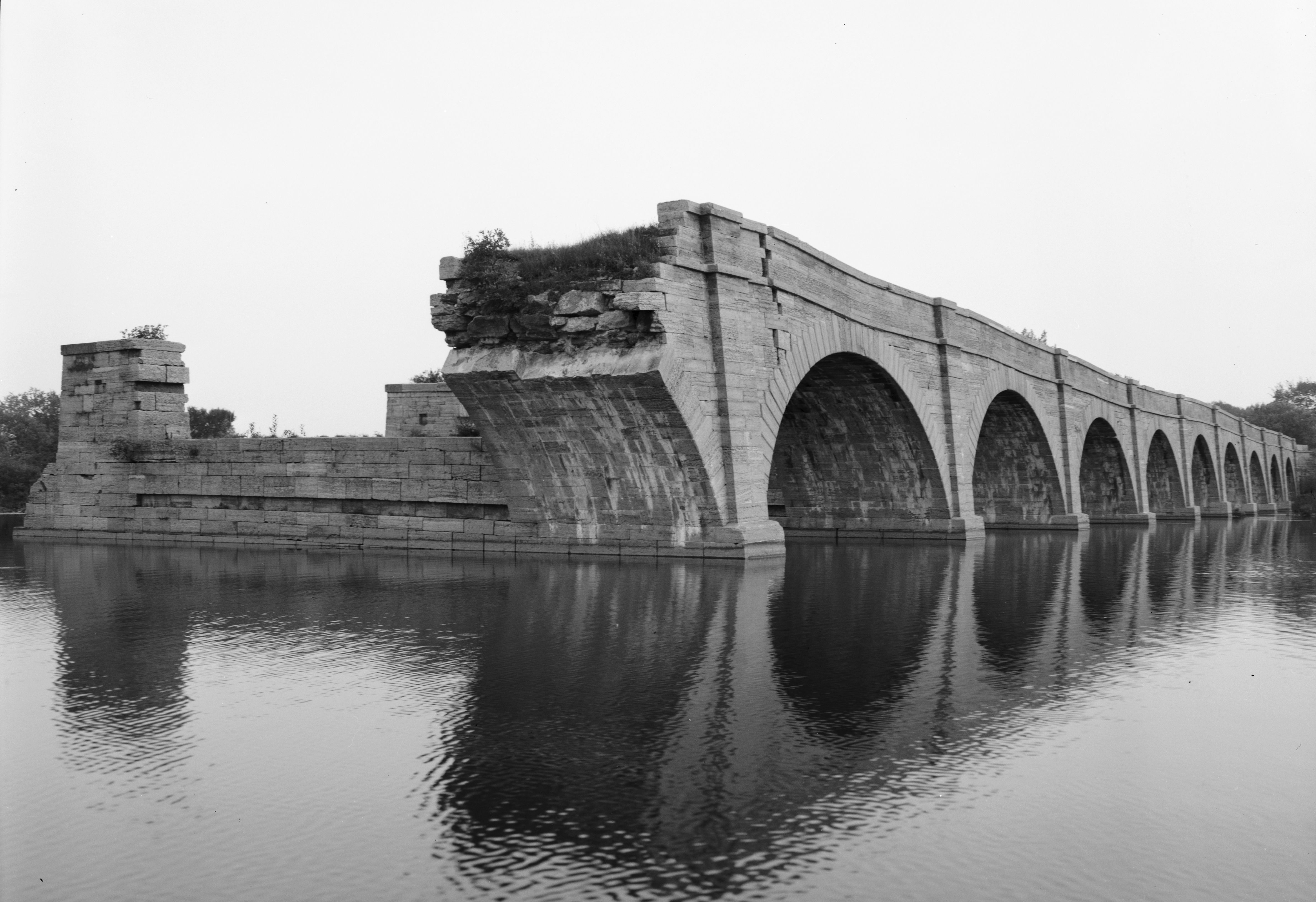
42°59′26″N 74°40′02″W / 42.990556°N 74.667222°WSt. Johnsville 12 Erie Canal 
October 15, 1966 6 mi. W of Amsterdam on NY 5S
42°56′38″N 74°16′02″W / 42.943889°N 74.267222°WFort Hunter Ruins of Erie Canal aqueduct over Schoharie Creek, and 3.5 mile segment of canal 13 First Baptist Church 
January 21, 1994 Polin Rd.
42°50′55″N 74°20′43″W / 42.848611°N 74.345278°WCharleston 14 Fort Johnson 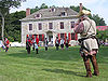
November 28, 1972 Jct. of NY 5 and 67
42°57′30″N 74°14′00″W / 42.958333°N 74.233333°WFort Johnson 15 Fort Klock 
November 28, 1972 2 mi. E of St. Johnsville on NY 5
42°59′06″N 74°39′01″W / 42.985°N 74.650278°WSt. Johnsville 16 Fort Plain Conservation Area November 15, 1979 Address Restricted Fort Plain 17 Frey House 
December 31, 2002 NY 5
42°54′43″N 74°35′04″W / 42.911944°N 74.584444°WPalatine Bridge 18 Caspar Getman Farmstead Caspar Getman FarmsteadAugust 30, 2010 1311 Stone Arabia Rd.
42°57′50″N 74°30′43″W / 42.963889°N 74.511944°WStone Arabia vicinity New listing; refnum 10000594 19 Glen Historic District 
August 8, 2001 NY 30A, NY 161 and Logtown Rd.
42°53′40″N 74°20′33″W / 42.894444°N 74.3425°WGlen 20 Gray-Jewett House October 5, 2005 80 Florida Ave.
42°56′01″N 74°12′00″W / 42.933611°N 74.2°WAmsterdam 21 Green Hill Cemetery March 15, 2005 Church and Cornell Sts.
42°56′16″N 74°11′05″W / 42.937778°N 74.184722°WAmsterdam 22 Greene Mansion December 31, 1979 92 Market St.
42°56′24″N 74°11′27″W / 42.94°N 74.190833°WAmsterdam 23 Guy Park 
February 6, 1973 W. Main St.
42°56′49″N 74°12′36″W / 42.946944°N 74.21°WAmsterdam 24 Guy Park Avenue School June 2, 1995 300 Guy Park Ave.
42°56′59″N 74°12′31″W / 42.949722°N 74.208611°WAmsterdam 25 Samuel and Johanna Jones Farm May 27, 1993 NY 67 W of jct. with NY 296
42°57′51″N 74°06′29″W / 42.964167°N 74.108056°WAmsterdam 26 Kilts Farmstead September 18, 2009 Address restricted Stone Arabia New listing; refnum 09000721 27 Lasher-Davis House September 27, 1980 U.S. 5
42°56′09″N 74°36′55″W / 42.935833°N 74.615278°WNelliston 28 Nellis Tavern May 10, 1990 SR 5
42°59′37″N 74°39′33″W / 42.993611°N 74.659167°WSt. Johnsville 29 Jacob Nellis Farmhouse September 27, 1980 Nellis St.
42°56′00″N 74°36′27″W / 42.933333°N 74.6075°WNelliston 30 Nelliston Historic District 
September 27, 1980 Prospect, River, Railroad and Berthoud Sts.
42°56′02″N 74°37′00″W / 42.933889°N 74.616667°WNelliston 31 Nelliston School December 31, 2002 Stone Arabia St.
42°56′08″N 74°36′49″W / 42.935556°N 74.613611°WNelliston 32 Palatine Bridge Freight House March 7, 1973 E of Palatine Bridge on NY 5
42°54′36″N 74°33′59″W / 42.91°N 74.566389°WPalatine Bridge 33 Palatine Church January 25, 1973 Mohawk Tpke.
42°58′08″N 74°37′44″W / 42.968889°N 74.628889°WPalatine 34 Pawling Hall November 15, 2002 86 Pawling St.
42°58′39″N 74°09′07″W / 42.9775°N 74.151944°WHagaman 35 Reformed Dutch Church of Stone Arabia 
September 14, 1977 E of Nelliston on NY 10
42°56′33″N 74°33′24″W / 42.9425°N 74.556667°WNelliston 36 Rice's Woods July 18, 1980 Address Restricted Canajoharie 37 Saint Stanislaus Roman Catholic Church Complex April 29, 1999 42, 46, 50 Cornell St., 73 Reid St.
42°56′39″N 74°10′58″W / 42.944167°N 74.182778°WAmsterdam 38 Stone Grist Mill Complex February 23, 1996 1679 Mill Rd.
43°00′17″N 74°41′47″W / 43.004722°N 74.696389°WSt. Johnsville 39 Samuel Sweet Canal Store September 19, 1989 65 Bridge St.
42°56′04″N 74°11′54″W / 42.934444°N 74.198333°WAmsterdam 40 Temple of Israel August 27, 1992 8 Mohawk Pl.
42°56′22″N 74°11′41″W / 42.939444°N 74.194722°WAmsterdam 41 Trinity Lutheran Church and Cemetery 
January 5, 2005 5430 NY 10
42°56′28″N 74°33′46″W / 42.941111°N 74.562778°WStone Arabia 42 US Post Office-Amsterdam 
November 17, 1988 12-16 Church St.
42°56′14″N 74°11′31″W / 42.937222°N 74.191944°WAmsterdam 43 US Post Office-Canajoharie November 17, 1988 50 W. Main St.
42°54′23″N 74°33′41″W / 42.906389°N 74.561389°WCanajoharie 44 US Post Office-Fort Plain 
May 11, 1989 41 River St.
42°55′54″N 74°37′23″W / 42.931667°N 74.623056°WFort Plain 45 US Post Office-St. Johnsville 
May 11, 1989 Main St.
42°59′55″N 74°40′42″W / 42.998611°N 74.678333°WSt. Johnsville 46 Van Alstyne House 
September 8, 1983 Moyer St.
42°54′12″N 74°34′22″W / 42.903333°N 74.572778°WCanajoharie 47 Van Wie Farmstead Van Wie FarmsteadJuly 14, 2011 269 Brower Rd.
42°54′10″N 74°31′31″W / 42.902778°N 74.525278°WMcKinley vicinity New listing; refnum 11000450 48 Vrooman Avenue School June 30, 1983 Vrooman Ave.
42°56′08″N 74°10′30″W / 42.935556°N 74.175°WAmsterdam 49 Webster Wagner House 
March 7, 1973 E. Grand St.
42°54′39″N 74°34′10″W / 42.910833°N 74.569444°WPalatine Bridge 50 Walrath-Van Horne House September 27, 1980 W. Main St.
42°56′29″N 74°37′08″W / 42.941389°N 74.618889°WNelliston 51 Waterman-Gramps House September 27, 1980 School St.
42°56′13″N 74°36′45″W / 42.936944°N 74.6125°WNelliston 52 West Hill School 
April 11, 2002 3 Otsego St.
42°54′17″N 74°34′25″W / 42.904722°N 74.573611°WCanajoharie 53 Windfall Dutch Barn November 22, 2000 Clinton Rd., jct. with Ripple Rd.
42°51′32″N 74°44′40″W / 42.858889°N 74.744444°WSalt Springville Similar Historic Site
- Fort Keyser in Stone Arabia, New York and/or Palatine was torn down in the 1840s. Fort Keyser, at New York State Military Museum and Veterans Center
See also
National Register of Historic Places listings in New York
References
- ^ The latitude and longitude information provided in this table was derived originally from the National Register Information System, which has been found to be fairly accurate for about 99% of listings. For about 1% of NRIS original coordinates, experience has shown that one or both coordinates are typos or otherwise extremely far off; some corrections may have been made. A more subtle problem causes many locations to be off by up to 150 yards, depending on location in the country: most NRIS coordinates were derived from tracing out latitude and longitudes off of USGS topographical quadrant maps created under North American Datum of 1927, which differs from the current, highly accurate GPS system used by Google maps. Chicago is about right, but NRIS longitudes in Washington are higher by about 4.5 seconds, and are lower by about 2.0 seconds in Maine. Latitudes differ by about 1.0 second in Florida. Some locations in this table may have been corrected to current GPS standards.
- ^ "National Register of Historic Places: Weekly List Actions". National Park Service, United States Department of the Interior. Retrieved on November 18, 2011.
- ^ Numbers represent an ordering by significant words. Various colorings, defined here, differentiate National Historic Landmark sites and National Register of Historic Places Districts from other NRHP buildings, structures, sites or objects.
Categories:- National Register of Historic Places in New York by county
- Montgomery County, New York
-


Wikimedia Foundation. 2010.