- National Register of Historic Places listings in Oswego County, New York
-
 Location of Oswego County in New York
List of the National Register of Historic Places listings in Oswego County, New York
This is intended to be a complete list of properties and districts listed on the National Register of Historic Places in Oswego County, New York. The locations of National Register properties and districts (at least for all showing latitude and longitude coordinates below) may be seen in a Google map by clicking on "Map of all coordinates".[1] One property, the Nash (tugboat) is further designated a National Historic Landmark of the United States.
-
- This National Park Service list is complete through NPS recent listings posted November 18, 2011.[2]
Contents: Counties in New York Albany (Albany) – Allegany – Bronx – Broome – Cattaraugus – Cayuga – Chautauqua – Chemung – Chenango – Clinton – Columbia – Cortland – Delaware – Dutchess – Erie (Buffalo) – Essex – Franklin – Fulton – Genesee – Greene – Hamilton – Herkimer – Jefferson – Kings (Brooklyn) – Lewis – Livingston – Madison – Monroe (Rochester) – Montgomery – Nassau – New York (Manhattan – Below 14th Street, 14th to 59th Streets, 59th to 110th Streets, Above 110th Street, Islands) – Niagara – Oneida – Onondaga (Syracuse) – Ontario – Orange – Orleans – Oswego – Otsego – Putnam – Queens – Rensselaer – Richmond (Staten Island) – Rockland – Saratoga – Schenectady – Schoharie – Schuyler – Seneca – St. Lawrence – Steuben – Suffolk – Sullivan – Tioga – Tompkins – Ulster – Warren – Washington – Wayne – Westchester (New Rochelle, Peekskill, Yonkers) – Wyoming – Yates Listings county-wide
[3] Landmark name Image Date listed Location City or town Summary 1 Leonard Ames Farmhouse November 14, 1991 5707 Main St.
43°27′38″N 76°14′30″W / 43.460556°N 76.241667°WMexico 2 Orson Ames House December 4, 2001 3339 Main St.
43°27′35″N 76°14′07″W / 43.459722°N 76.235278°WMexico 3 Arthur Tavern November 14, 1991 Jct. of Clarke Rd. and NY 16
43°29′42″N 76°14′57″W / 43.495°N 76.249167°WArthur 4 Smith H. Barlow House November 15, 1988 Harwood Dr.
43°38′36″N 76°04′30″W / 43.643333°N 76.075°WLacona 5 Brosemer Brewery Brosemer BreweryMarch 29, 2010 472 W. First St.
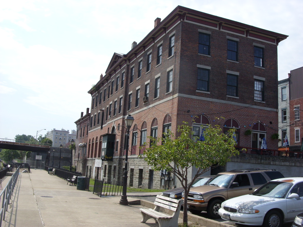
43°26′45″N 76°30′11″W / 43.445833°N 76.503056°WOswego New listing; refnum 10000102 6 Buckhout-Jones Building December 4, 2001 5-13 W. Bridge St.
43°27′24″N 76°30′41″W / 43.456667°N 76.511389°WOswego 7 Carley's Mills Schoolhouse January 5, 2005 Oswego Cty Rte 84
43°22′24″N 76°07′02″W / 43.373333°N 76.117222°WHastings 8 Chancellor (tugboat) February 18, 2000 Oswego R.
43°19′11″N 76°25′03″W / 43.319722°N 76.4175°WFulton 9 Peter Chandler House November 14, 1991 5897 Main St.
43°27′35″N 76°13′45″W / 43.459722°N 76.229167°WMexico 10 Starr Clark Tin Shop December 4, 2001 3250 Main St.
43°27′35″N 76°13′43″W / 43.459722°N 76.228611°WMexico 11 Edwin W. and Charlotte Clarke House February 26, 2002 80 E. Mohawk St.
43°27′24″N 76°30′02″W / 43.456667°N 76.500556°WOswego 12 Phineas Davis Farmstead June 20, 1991 5422 North Rd.
43°27′55″N 76°13′37″W / 43.465278°N 76.226944°WMexico 13 John B. and Lydia Edwards House December 4, 2001 144 E. Third St.
43°27′17″N 76°30′16″W / 43.454722°N 76.504444°WOswego 14 First Baptist Church November 15, 1988 Harwood Dr.
43°38′38″N 76°04′40″W / 43.643889°N 76.077778°WSandy Creek 15 First Congregational Church and Society of Volney June 29, 2001 NY 3
43°20′18″N 76°20′19″W / 43.338333°N 76.338611°WVolney 16 First National Bank of Lacona November 15, 1988 Harwood Dr. and Salina St.
43°38′36″N 76°04′10″W / 43.643333°N 76.069444°WLacona 17 Fort Brewerton March 7, 1973 State and Lansing Sts.
43°14′32″N 76°08′29″W / 43.242222°N 76.141389°WBrewerton 18 Fort Ontario Fort OntarioDecember 18, 1970 E. 7th St. and Lake Ontario
43°27′55″N 76°30′31″W / 43.465278°N 76.508611°WOswego 19 Fowler-Loomis House November 14, 1991 6022 Main St.
43°27′32″N 76°13′16″W / 43.458889°N 76.221111°WMexico 20 Franklin Square Historic District August 4, 1982 Roughly bounded by 3rd, 6th, Van Buren, and Bridge Sts.
43°27′25″N 76°30′59″W / 43.456944°N 76.516389°WOswego 21 Fulton Public Library January 15, 1999 160 S. First St.
43°19′10″N 76°24′59″W / 43.319444°N 76.416389°WFulton 22 Nathan and Clarissa Green House February 26, 2002 98 West Eight St.
43°27′22″N 76°31′13″W / 43.456111°N 76.520278°WOswego 23 Hamilton Farmstead November 18, 1991 5644 Hamilton St.
43°28′30″N 76°13′52″W / 43.475°N 76.231111°WMexico 24 Holyoke Cottage November 15, 1988 Seber Shore Rd.
43°38′45″N 76°09′56″W / 43.645833°N 76.165556°WSandy Creek 25 Hunter-Oliphant Block July 21, 1995 215-219 W. First St.
43°27′20″N 76°30′39″W / 43.455556°N 76.510833°WOswego 26 Kingsford House August 21, 1997 150 W. Third St.
43°27′16″N 76°30′47″W / 43.454444°N 76.513056°WOswego 27 Lacona Clock Tower November 15, 1988 Harwood Dr.
43°38′36″N 76°04′12″W / 43.643333°N 76.07°WLacona 28 Lacona Railroad Station and Depot January 24, 2002 11 Park Ave.
43°38′34″N 76°04′13″W / 43.642778°N 76.070278°WLacona 29 Hamilton and Rhoda Littlefield House February 26, 2002 44 E. Oneida St.
43°27′25″N 76°30′16″W / 43.456944°N 76.504444°WOswego 30 Market House 
June 20, 1974 Water St.
43°27′26″N 76°30′39″W / 43.457222°N 76.510833°WOswego 31 John and Harriet McKenzie House December 4, 2001 96 W. Eighth St.
43°27′23″N 76°31′13″W / 43.456389°N 76.520278°WOswego 32 Methodist Church November 15, 1988 Harwood Dr.
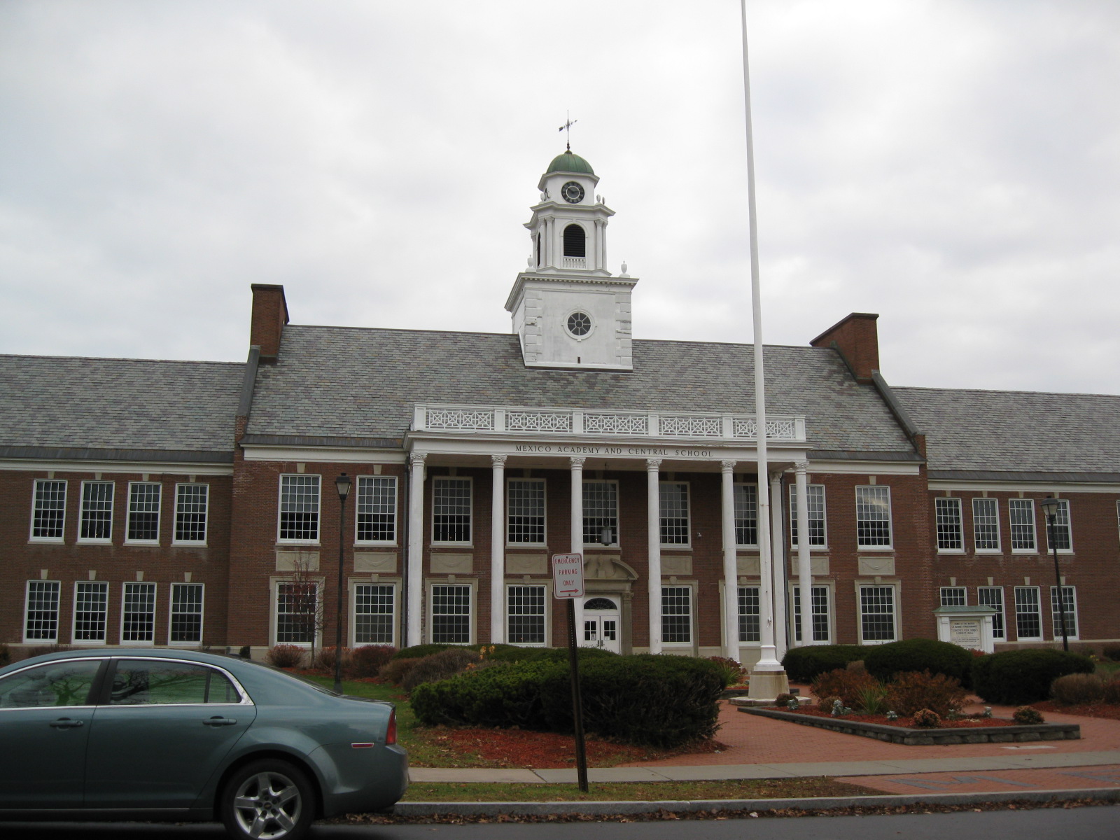
43°38′37″N 76°04′58″W / 43.643611°N 76.082778°WSandy Creek 33 Mexico Academy and Central School 
November 14, 1991 5805 Main St.
43°27′37″N 76°14′06″W / 43.460278°N 76.235°WMexico 34 Mexico Octagon Barn June 20, 1991 5276 Ames St.
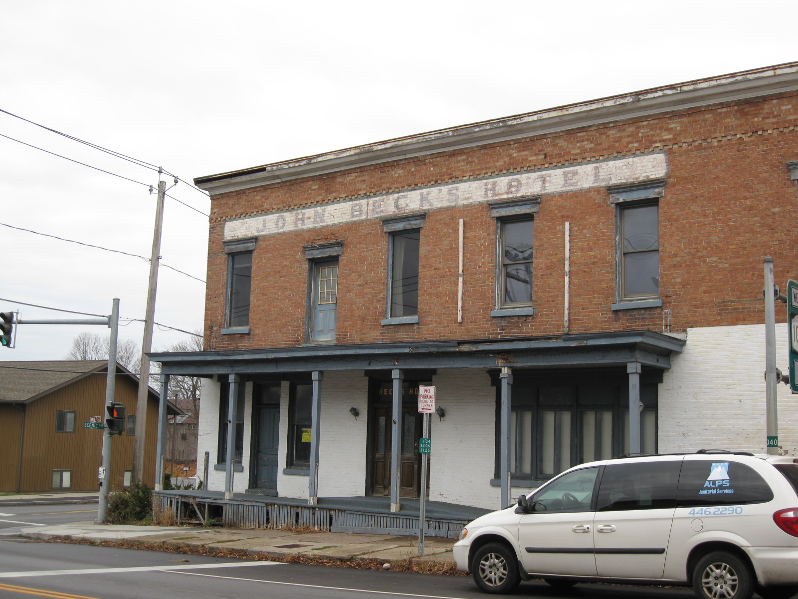
43°27′08″N 76°14′31″W / 43.452222°N 76.241944°WMexico 35 Mexico Railroad Depot June 20, 1991 5530 Scenic Ave.
43°28′09″N 76°13′57″W / 43.469167°N 76.2325°WMexico 36 The Mexico Stone Store The Mexico Stone StoreMarch 23, 2010 3201 Main St.
43°27′35″N 76°13′33″W / 43.459708°N 76.225836°WMexico New listing; refnum 10000103 37 Mexico Village Historic District 
June 20, 1991 Main, Jefferson, Church and Spring Sts.
43°27′29″N 76°13′46″W / 43.458056°N 76.229444°WMexico 38 Montcalm Park Historic District May 25, 2001 Roughly Montcalm St., W 6th St., W. Schuyler St., and Bronson St., vic. of Montcalm Park
43°27′35″N 76°31′11″W / 43.459722°N 76.519722°WOswego 39 Mount Adnah Cemetery February 2, 2001 706 East Broadway
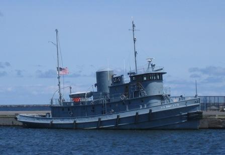
43°19′14″N 76°24′12″W / 43.320556°N 76.403333°WFulton 40 Nash (harbor tug) 
December 4, 1991 H. Lee White Marine Museum, West 1st Street Pier
43°27′52″N 76°30′58″W / 43.464536°N 76.51605°WOswego Last surviving Army ship which served at D-Day 41 Northrup-Gilbert House February 4, 2000 25 Church St.
43°13′43″N 76°17′49″W / 43.228611°N 76.296944°WPhoenix 42 Oak Street School July 3, 2003 205 Oak St.
43°18′43″N 76°25′07″W / 43.311944°N 76.418611°WFulton 43 Oswego Armory 
May 19, 1988 265 W. First St.
43°27′14″N 76°30′35″W / 43.453889°N 76.509722°WOswego 44 Oswego City Hall February 20, 1973 W. Oneida St.
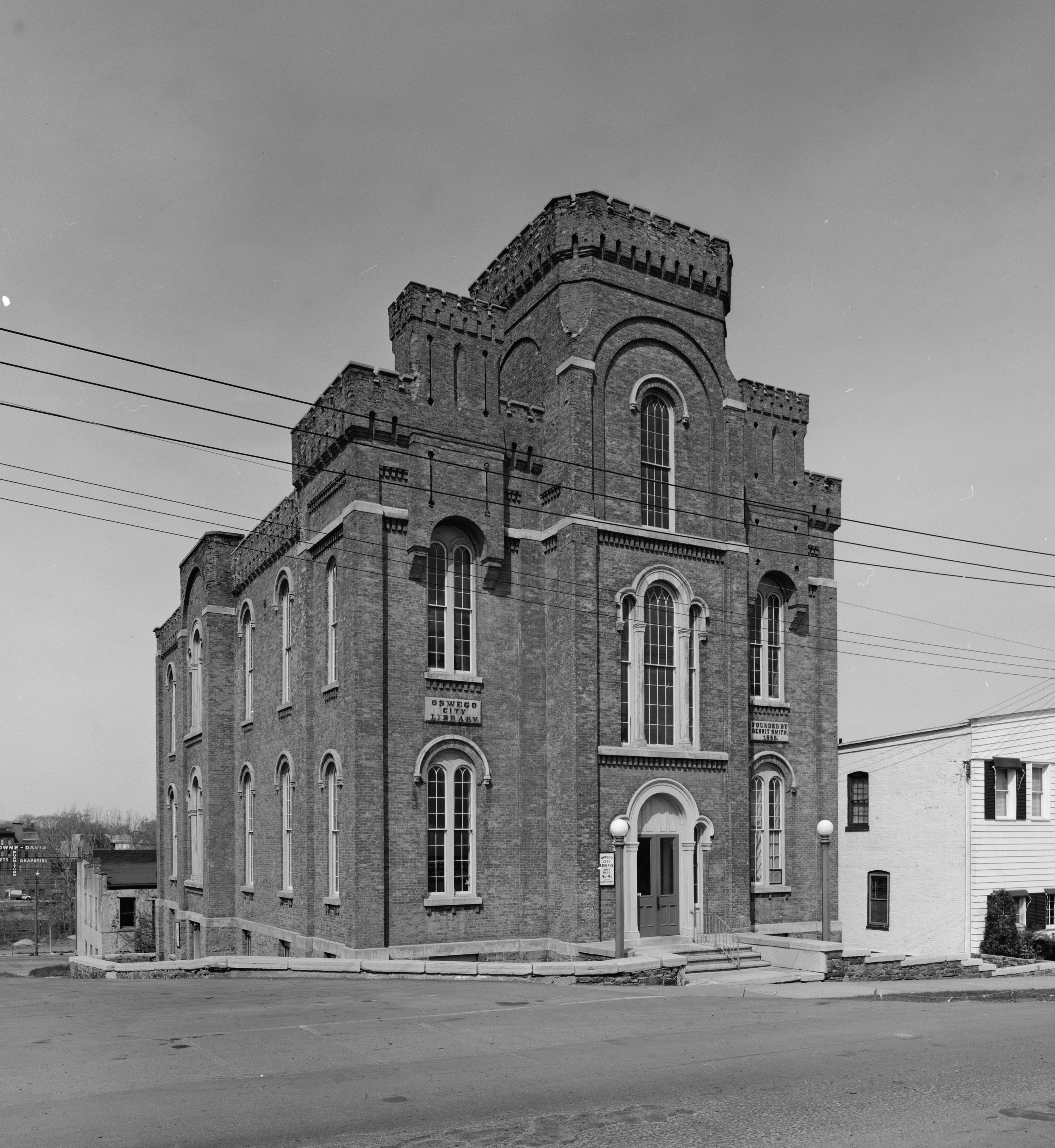
43°27′19″N 76°30′42″W / 43.455278°N 76.511667°WOswego 45 Oswego City Library 
September 22, 1971 120 E. 2nd St.
43°27′24″N 76°30′25″W / 43.456667°N 76.506944°WOswego 46 Oswego County Courthouse 
December 7, 2000 East Bridge St.
43°27′26″N 76°30′22″W / 43.457222°N 76.506111°WOswego 47 Oswego Theater September 19, 1988 138 W. Second St.
43°27′21″N 76°30′46″W / 43.455833°N 76.512778°WOswego 48 Oswego West Pierhead Lighthouse 
December 1, 2000 Lake Ontario, 0.5 mi. N of Oswego R.
43°28′24″N 76°31′02″W / 43.473333°N 76.517222°WOswego 49 Oswego Yacht Club Oswego Yacht ClubMarch 23, 2010 41 Lake St.
43°27′44″N 76°31′16″W / 43.462203°N 76.5212°WOswego New listing; refnum 10000105 50 Daniel and Miriam Pease House February 26, 2002 361 Cemetery Rd.
43°25′33″N 76°33′37″W / 43.425833°N 76.560278°WOswego 51 Newton M. Pitt House November 15, 1988 8114 Harwood Dr.
43°38′37″N 76°05′00″W / 43.643611°N 76.083333°WSandy Creek 52 Pleasant Lawn Cemetery October 5, 2005 NY 69A
43°24′08″N 76°08′31″W / 43.402222°N 76.141944°WParish 53 Pontiac Hotel July 21, 1983 W. 1st St.
43°26′14″N 76°30′37″W / 43.437222°N 76.510278°WOswego 54 John Wells Pratt House December 10, 1999 177 S. 1st St.
43°19′06″N 76°24′53″W / 43.318333°N 76.414722°WFulton 55 Pulaski Village Historic District September 8, 1983 Jefferson, Broad, Bridge, Hubbel and Lake Sts.
43°34′01″N 76°07′43″W / 43.566944°N 76.128611°WPulaski 56 Red Mill Farm November 14, 1991 7177 Red Mill Rd.
43°25′28″N 76°08′45″W / 43.424444°N 76.145833°WColosse 57 Richardson-Bates House September 5, 1975 135 E. 3rd St.
43°27′21″N 76°30′16″W / 43.455833°N 76.504444°WOswego 58 Riverside Cemetery August 19, 1993 E. River Rd. S of jct. with NY 57
43°25′24″N 76°28′34″W / 43.423333°N 76.476111°WOswego 59 Samuel Sadler House November 15, 1988 N. Main St.
43°38′55″N 76°05′07″W / 43.648611°N 76.085278°WSandy Creek 60 St. James' Church (Cleveland, New York) August 30, 1996 North St., jct. with Bridge St.
43°14′02″N 75°52′56″W / 43.233889°N 75.882222°WCleveland 61 St. John's Episcopal Church May 27, 1993 670 Main St.
43°13′53″N 76°18′04″W / 43.231389°N 76.301111°WPhoenix 62 Charles M. Salisbury House November 15, 1988 9089 Church St.
43°38′29″N 76°04′06″W / 43.641389°N 76.068333°WLacona 63 Sandy Creek Historic District November 15, 1988 Jct. of Lake Rd. and US 11
43°38′39″N 76°05′10″W / 43.644167°N 76.086111°WSandy Creek 64 Schroeppel House September 9, 1982 Morgan Rd.
43°12′20″N 76°13′08″W / 43.205556°N 76.218889°WSchroeppel 65 Selkirk Lighthouse 
March 30, 1979 W of Pulaski on Lake Rd.
43°34′28″N 76°12′07″W / 43.574444°N 76.201944°WPulaski 66 Sheldon Hall May 13, 1980 Washington Blvd.
43°27′16″N 76°32′12″W / 43.454444°N 76.536667°WOswego 67 Matthew Shoecraft House November 15, 1988 Ridge Rd. at Smartville Rd.
43°38′33″N 76°03′45″W / 43.6425°N 76.0625°WLacona 68 Timothy Skinner House June 20, 1991 5355 Scenic Ave.
43°27′40″N 76°13′57″W / 43.461111°N 76.2325°WMexico 69 Slack Farmstead November 14, 1991 5174 Row Rd.
43°27′07″N 76°11′07″W / 43.451944°N 76.185278°WMexico 70 George B. Sloan Estate August 11, 1988 107 W. Van Buren St.
43°27′35″N 76°31′17″W / 43.459722°N 76.521389°WOswego 71 Fred Smart House November 15, 1988 Salina St.
43°38′35″N 76°04′08″W / 43.643056°N 76.068889°WLacona 72 Standard Yarn Company Building May 15, 2008 317 W. 1st St.
43°27′08″N 76°30′30″W / 43.452222°N 76.508333°WOswego (new listing; refnum 08000410) 73 Stillman Farmstead June 20, 1991 NY 104 between Co. Rt. 58 and US 11
43°27′33″N 76°09′47″W / 43.459167°N 76.163056°WMexico 74 Stillwater Bridge November 7, 1997 Dam Rd. over Salmon R.
43°32′41″N 75°55′20″W / 43.544722°N 75.922222°WStillwater 75 Sweet Memorial Building April 26, 1990 821 Main St.
43°13′45″N 76°17′58″W / 43.229167°N 76.299444°WPhoenix 76 Tanner Block Tanner BlockDecember 25, 2009 175-177 W. First St.
43°27′25″N 76°30′41″W / 43.456922°N 76.511444°WOswego New listing; refnum 09001269 77 Thayer Farmstead November 14, 1991 5933 Church St.
43°27′11″N 76°13′35″W / 43.453056°N 76.226389°WMexico 78 Trinity Church 
October 29, 1982 NY 49
43°14′52″N 76°00′29″W / 43.247778°N 76.008056°WConstantia 79 Newman Tuttle House November 15, 1988 Harwood Dr. at Ridge Rd.
43°38′37″N 76°03′51″W / 43.643611°N 76.064167°WLacona 80 U.S. Customhouse November 21, 1976 W. Oneida St. between 1st and 2nd Sts.
43°27′17″N 76°30′40″W / 43.454722°N 76.511111°WOswego 81 US Post Office-Fulton May 11, 1989 214 S. First St.
43°19′03″N 76°24′53″W / 43.3175°N 76.414722°WFulton 82 David Van Buren House June 9, 1988 Van Buren Dr., W end at the Oswego River
43°21′37″N 76°25′45″W / 43.360278°N 76.429167°WFulton 83 John Van Buren Tavern November 3, 1988 NY 57 and Van Buren Dr.
43°21′35″N 76°25′45″W / 43.359722°N 76.429167°WFulton 84 Volkert Van Buren House October 7, 1988 NY 57 and Distin Rd.
43°22′01″N 76°25′34″W / 43.366944°N 76.426111°WFulton 85 Walton and Willett Stone Store May 24, 1976 1 Seneca St.
43°27′35″N 76°30′43″W / 43.459722°N 76.511944°WOswego 86 Washington Square Historic District Washington Square Historic DistrictDecember 25, 2009 E. 4th St., E. Oneida St., E. 3rd St.
43°27′26″N 76°30′16″W / 43.457117°N 76.504383°WOswego New listing; refnum 09001270 87 Asa and Caroline Wing House December 4, 2001 3392 NY 69
43°25′15″N 76°09′52″W / 43.420833°N 76.164444°WMexico 88 Woodruff Block April 20, 1995 17 W. Cayuga St.
43°27′28″N 76°30′46″W / 43.457778°N 76.512778°WOswego See also
References
- ^ The latitude and longitude information provided in this table was derived originally from the National Register Information System, which has been found to be fairly accurate for about 99% of listings. For about 1% of NRIS original coordinates, experience has shown that one or both coordinates are typos or otherwise extremely far off; some corrections may have been made. A more subtle problem causes many locations to be off by up to 150 yards, depending on location in the country: most NRIS coordinates were derived from tracing out latitude and longitudes off of USGS topographical quadrant maps created under the North American Datum of 1927, which differs from the current, highly accurate WGS84 GPS system used by Google maps. Chicago is about right, but NRIS longitudes in Washington are higher by about 4.5 seconds, and are lower by about 2.0 seconds in Maine. Latitudes differ by about 1.0 second in Florida. Some locations in this table may have been corrected to current GPS standards.
- ^ "National Register of Historic Places: Weekly List Actions". National Park Service, United States Department of the Interior. Retrieved on November 18, 2011.
- ^ Numbers represent an ordering by significant words. Various colorings, defined here, differentiate National Historic Landmark sites and National Register of Historic Places Districts from other NRHP buildings, structures, sites or objects.
Categories:- National Register of Historic Places in New York by county
- Buildings and structures in Oswego County, New York
-


Wikimedia Foundation. 2010.