- National Register of Historic Places listings in Queens County, New York
-
 Location of Queens County in New York
List of the National Register of Historic Places listings in Queens County, New York
This is intended to be a complete list of properties and districts listed on the National Register of Historic Places in Queens County, New York. The locations of National Register properties and districts (at least for all showing latitude and longitude coordinates below) may be seen in a Google map by clicking on "Map of all coordinates".[1] Four of the properties are further designated as U.S. National Historic Landmarks.
-
- This National Park Service list is complete through NPS recent listings posted November 18, 2011.[2]
Contents: Counties in New York Albany (Albany) – Allegany – Bronx – Broome – Cattaraugus – Cayuga – Chautauqua – Chemung – Chenango – Clinton – Columbia – Cortland – Delaware – Dutchess – Erie (Buffalo) – Essex – Franklin – Fulton – Genesee – Greene – Hamilton – Herkimer – Jefferson – Kings (Brooklyn) – Lewis – Livingston – Madison – Monroe (Rochester) – Montgomery – Nassau – New York (Manhattan – Below 14th Street, 14th to 59th Streets, 59th to 110th Streets, Above 110th Street, Islands) – Niagara – Oneida – Onondaga (Syracuse) – Ontario – Orange – Orleans – Oswego – Otsego – Putnam – Queens – Rensselaer – Richmond (Staten Island) – Rockland – Saratoga – Schenectady – Schoharie – Schuyler – Seneca – St. Lawrence – Steuben – Suffolk – Sullivan – Tioga – Tompkins – Ulster – Warren – Washington – Wayne – Westchester (New Rochelle, Peekskill, Yonkers) – Wyoming – Yates Listings county-wide
Landmark name Image Date listed Location City or Town Summary 1 1964-1965 New York World's Fair New York State Pavilion 
November 20, 2009 Flushing Meadows – Corona Park
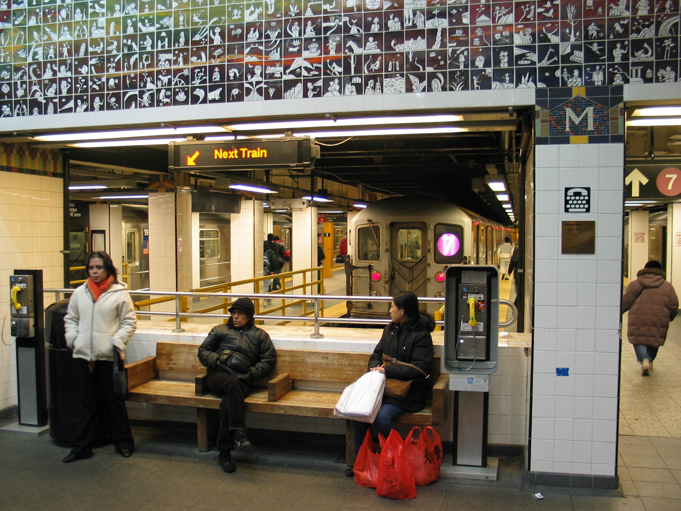
40°44′38.5″N 73°50′39.9″W / 40.744028°N 73.844417°WFlushing 2 45th Road – Court House Square Subway station (7 <7> trains) 
March 30, 2005 Above 23rd St. bet. 44th Dr. and 45ht Rd.
40°44′47″N 73°56′45″W / 40.74639°N 73.94583°WLong Island City 3 68th Avenue-64th Place Historic District September 30, 1983 Roughly 64th Pl. from Catalpa Ave. to 68th Ave. from 64th St. to 65th St.
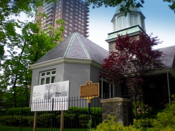
40°42′20″N 73°53′40″W / 40.70556°N 73.89444°WRidgewood 4 75th Avenue-61st Street Historic District September 30, 1983 Roughly bounded by St. Felix Ave., 60th Lane, 60th and 62nd Sts.
40°41′55″N 73°53′41″W / 40.69861°N 73.89472°WRidgewood 5 Allen-Beville House September 22, 1983 29 Center Dr.
40°46′22″N 73°45′3″W / 40.77278°N 73.75083°WDouglaston 6 Louis Armstrong House 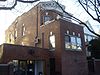
May 11, 1976 3456 107th St.
40°45′20″N 73°51′43″W / 40.75556°N 73.86194°WCorona 7 Astoria Center of Israel October 16, 2009 27-35 Crescent St.
40°46′12.79″N 73°55′25.58″W / 40.7702194°N 73.9237722°WAstoria 8 Bohemian Hall and Park 
March 23, 2001 29-19 24th Ave.
40°46′22″N 73°54′59″W / 40.77278°N 73.91639°WAstoria 9 John Bowne House 
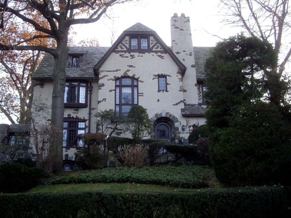
September 13, 1977 37-01 Bowne St.
40°45′46″N 73°49′32″W / 40.76278°N 73.82556°WFlushing 10 Broadway-Flushing Historic District May 12, 2006 Roughly bounded by 29th Ave., 163rd St., 32nd Ave., 192nd St., 154th and 153rd Sts.
40°46′0″N 73°48′5″W / 40.766667°N 73.80139°WFlushing 11 Ralph Bunche House 
May 11, 1976 115-125 Grosvenor Rd.
40°42′25″N 73°50′16″W / 40.70694°N 73.83778°WKew Gardens 12 Central Avenue Historic District September 30, 1983 Roughly bounded by Myrtle and 70th Ave., and 65th and 66th Sts.
40°42′10″N 73°53′25″W / 40.70278°N 73.89028°WRidgewood 13 Central Ridgewood Historic District September 30, 1983 Roughly bounded by Fresh Pond Rd., Putnam, 68th, Forest, Catalpa, Onderdonk, and 71st Aves.
40°42′10″N 73°53′57″W / 40.70278°N 73.89917°WRidgewood 14 The Church-in-the-Gardens December 11, 2009 50 Ascan Ave.
40°42′55.13″N 73°50′33.05″W / 40.7153139°N 73.8425139°WForest Hills New listing; refnum 09001086 15 Church of the Resurrection March 7, 2003 85-09 118th St.
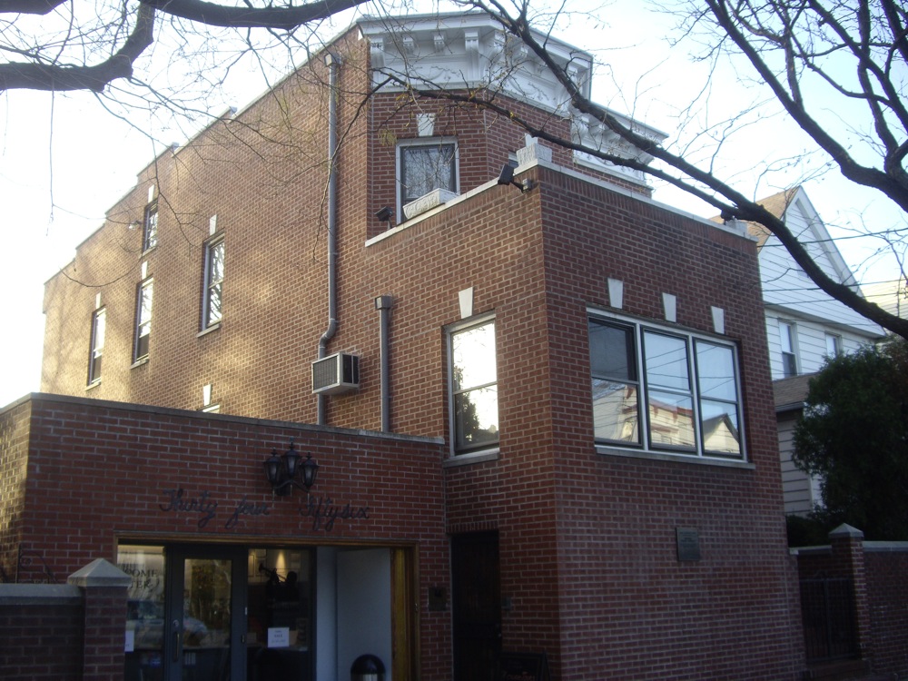
40°42′8.2476″N 73°49′56.7114″W / 40.702291°N 73.832419833°WKew Gardens/Richmond Hill 16 Congregation Tifereth Israel November 21, 2002 109-18 and 109-20 54th Ave.
40°44′32″N 73°51′12″W / 40.74222°N 73.85333°WCorona 17 Cooper Avenue Row Historic District September 30, 1983 6434-6446 Cooper Ave.
40°41′53″N 73°53′27″W / 40.69806°N 73.89083°WRidgewood 18 Cornelia-Putnam Historic District September 30, 1983 Roughly bounded by Jefferson St., Putnam, Wyckoff, and Myrtle Aves.
40°41′56″N 73°54′27″W / 40.69889°N 73.9075°WRidgewood 19 Cornell Farmhouse 
July 24, 1979 73-50 Little Neck Pkwy
40°44′54″N 73°43′14″W / 40.74833°N 73.72056°WFloral Park 20 Cypress Avenue East Historic District September 30, 1983 Roughly bounded by Linden and Cornelia Sts., Seneca and St. Nicholas Aves.
40°42′6″N 73°54′31″W / 40.70167°N 73.90861°WRidgewood 21 Cypress Avenue West Historic District September 30, 1983 Roughly bounded by St. Nicholas and Seneca Aves., Linden and Stockholm Sts.
40°42′6″N 73°54′15″W / 40.70167°N 73.90417°WRidgewood 22 Douglaston Hill Historic District August 31, 2000 Roughly bounded by Douglaston Pkwy., Northern Blvd., 244th St., 243rd St., and Long Island RR
40°46′3″N 73°44′43″W / 40.7675°N 73.74528°WDouglaston 23 Douglaston Historic District September 1, 2005 Roughly bounded by Shore Rd., Marinette St., Douglas Rd. and Cherry St.
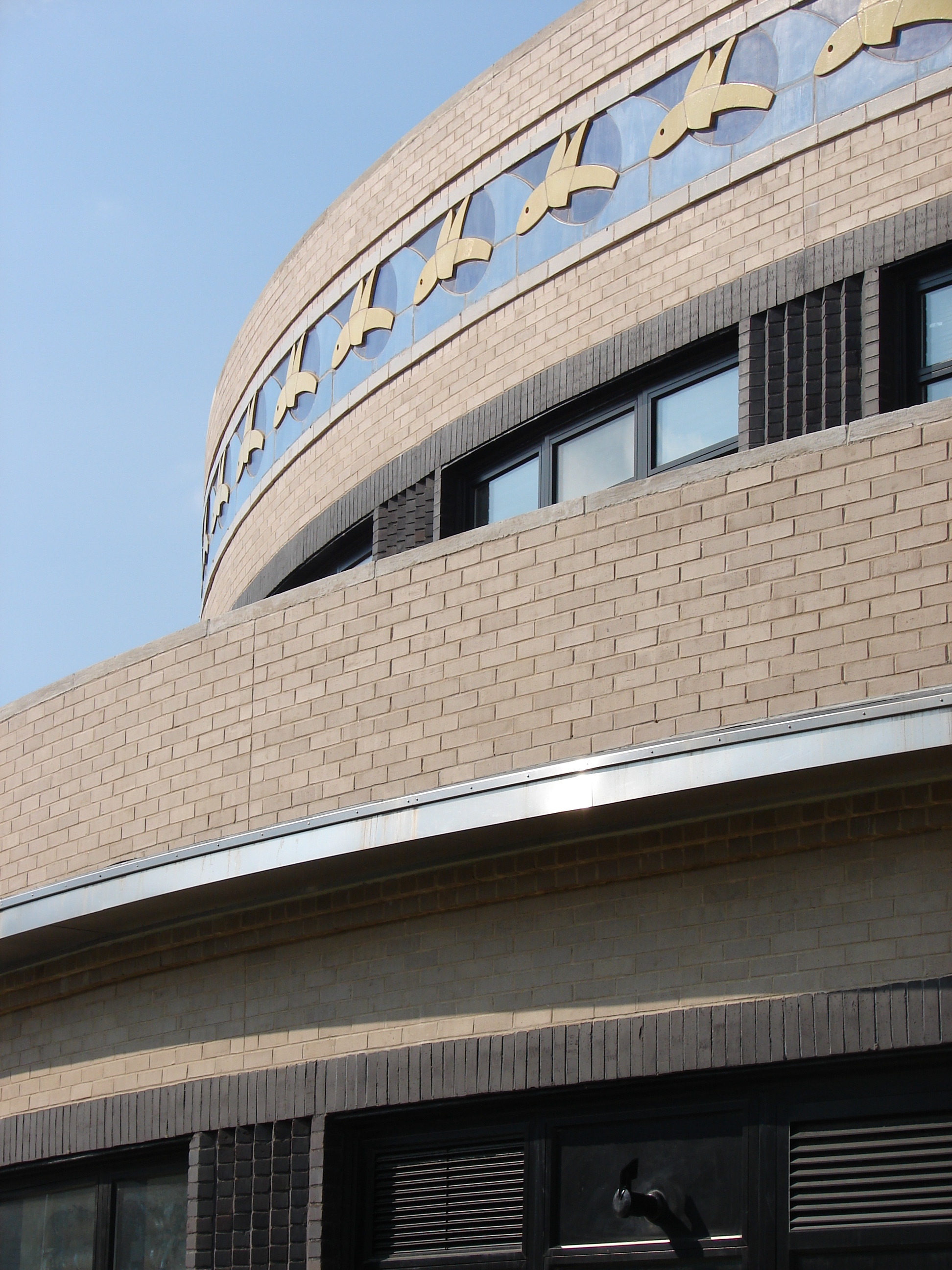
40°46′33″N 73°45′2″W / 40.77583°N 73.75056°WDouglaston 24 Elmhurst Avenue Subway station (E M R trains) 
July 6, 2005 Beneath Broadway at 82nd St. and 45th Ave. and Elmhurst Ave.
40°44′33″N 73°52′56″W / 40.7425°N 73.88222°WElmhurst 25 Evergreens Cemetery 
November 15, 2007 1629 Bushwick Ave.
40°41′2″N 73°54′4.31″W / 40.68389°N 73.9011972°WRidgewood 26 Firemen's Hall August 31, 2000 13-28 123rd St.
40°47′9″N 73°50′44″W / 40.78583°N 73.84556°WCollege Point 27 First Reformed Church 
April 16, 1980 153-10 Jamaica Ave.
40°42′9″N 73°48′8″W / 40.7025°N 73.80222°WJamaica 28 Flushing Armory 
March 23, 1995 137-58 Northern Boulevard
40°45′47″N 73°49′46″W / 40.76306°N 73.82944°WFlushing 29 Flushing High School 
February 10, 1992 35-01 Union St.
40°45′54″N 73°49′39″W / 40.765°N 73.8275°WFlushing 30 Flushing Town Hall 
March 16, 1972 137-35 Northern Blvd.
40°45′50″N 73°49′49″W / 40.76389°N 73.83028°WFlushing 1862, now Flushing Council on the Arts 31 Forest Park Carousel 
July 16, 2004 Woodhaven Blvd. and Myrtle Ave.
40°42′3″N 73°51′31″W / 40.70083°N 73.85861°WWoodhaven 32 Forest-Norman Historic District September 30, 1983 Forest Ave. from Summerfield to Stephen St. and Norman St. to Myrtle Ave.
40°41′59″N 73°53′58″W / 40.69972°N 73.89944°WMiddle Village 33 Fort Tilden Historic District 
April 20, 1984 Rockaway Beach Boulevard
40°33′50″N 73°53′28″W / 40.56389°N 73.89111°WRockaway 34 Fort Totten Officers' Club 
March 17, 1986 Totten and Murray Aves.
40°47′32″N 73°46′41″W / 40.79222°N 73.77806°WBayside 35 Free Synagogue of Flushing October 16, 2009 41-60 Kissena Blvd.
40°45′26.85″N 73°49′39.71″W / 40.7574583°N 73.8276972°WFlushing 36 Fresh Pond-Traffic Historic District September 30, 1983 Roughly bounded by Fresh Pond Rd., Traffic Ave., Woodbine and Linden Sts.
40°42′34″N 73°53′49″W / 40.70944°N 73.89694°WRidgewood 37 Grace Episcopal Church Complex 
September 8, 1983 15515 Jamaica Avenue
40°42′14″N 73°48′7″W / 40.70389°N 73.80194°WJamaica 38 Grove-Linden-St. John's Historic District September 30, 1983 Fairview Ave., St. John's Rd., Linden and Grove Sts.
40°42′23″N 73°54′26″W / 40.70639°N 73.90722°WMiddle Village 39 Hunters Point Historic District September 19, 1973 Along 45th Ave., between 21st and 23rd Sts.
40°44′49″N 73°56′48″W / 40.74694°N 73.94667°WLong Island City 40 Jackson Heights Historic District January 27, 1999 Bounded by Roosevelt Ave., Broadway, Leverich St., Northern Blvd., and 90th St.
40°45′5″N 73°53′13″W / 40.75139°N 73.88694°WJackson Heights 41 Jacob Riis Park Historic District June 17, 1981 Rockaway Beach Blvd.
40°34′3″N 73°52′24″W / 40.5675°N 73.87333°WRockaway Presumably including but larger than Jacob Riis Park 42 Jamaica Chamber of Commerce Building September 8, 1983 8931 161st St.
40°42′19″N 73°48′0″W / 40.70528°N 73.8°WJamaica 43 Jamaica Savings Bank May 19, 1983 161-02 Jamaica Ave.
40°42′14″N 73°47′57″W / 40.70389°N 73.79917°WJamaica 44 King Manor 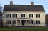
December 2, 1974 150th St. and Jamaica Ave.
40°42′11″N 73°51′43″W / 40.70306°N 73.86194°WJamaica 45 Kingsland Homestead May 31, 1972 37th St. and Parsons Blvd.
40°45′49″N 73°49′27″W / 40.76361°N 73.82417°WFlushing 46 J. Kurtz and Sons Store Building September 8, 1983 162-24 Jamaica Ave.
40°42′16″N 73°47′52″W / 40.70444°N 73.79778°WJamaica 47 La Casina March 1, 1990 90-33 160th St.
40°42′16″N 73°48′0″W / 40.70444°N 73.8°WJamaica 48 Lent Homestead and Cemetery February 2, 1984 78-03 19th Rd.
40°46′23″N 73°53′31″W / 40.77306°N 73.89194°WJackson Heights 49 Long Island City Courthouse Complex 
September 26, 1983 25-10 Court Sq.
40°44′45″N 73°56′36″W / 40.74583°N 73.94333°WLong Island City 50 Long Island Motor Parkway 
April 1, 2002 Roughly Alley Pond and Cunningham Parks, bet. Winchester Blvd. and Clearview Expressway, bet. 73rd Ave. and Peck Ave.
40°44′13″N 73°45′35″W / 40.73694°N 73.75972°WQueens 51 Madison-Putnam-60th Place Historic District September 30, 1983 Roughly bounded by Woodbine St., 60th Pl., 67th and Forest Aves.
40°42′21″N 73°54′6″W / 40.70583°N 73.90167°WRidgewood 52 Main Street Subway station (7 <7> trains) 
October 14, 2004 Near jct. of Roosevelt Ave. and Main St.
40°45′34″N 73°49′51″W / 40.75944°N 73.83083°WFlushing 53 Maple Grove Cemetery 
August 20, 2004 83-15 Kew Gardens Rd.
40°42′31″N 73°49′27″W / 40.70861°N 73.82417°WKew Gardens 54 Marine Air Terminal 
July 9, 1982 La Guardia Airport
40°46′25″N 73°53′10″W / 40.77361°N 73.88611°WLa Guardia Airport 55 Office of the Register January 3, 1980 161-04 Jamaica Ave.
40°42′13″N 73°47′57″W / 40.70361°N 73.79917°WJamaica 56 Old Quaker Meetinghouse 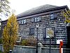
December 24, 1967 S side of Northern Blvd.
40°45′47″N 73°49′51″W / 40.76306°N 73.83083°WFlushing 57 Paramount Studios Complex 
November 14, 1978 35th Ave., 35th, 36th, and 37th Sts.
40°45′24″N 73°55′30″W / 40.75667°N 73.925°WAstoria Now Kaufman Astoria Studios 58 Poppenhusen Institute 
August 18, 1977 114-04 14th Rd.
40°47′4″N 73°51′13″W / 40.78444°N 73.85361°WCollege Point 59 Prospect Cemetery January 11, 2002 159th St. and Beaver Rd.
40°42′4″N 73°48′1″W / 40.70111°N 73.80028°WJamaica 60 Public School 66 August 28, 2003 85-11 102nd St.
40°41′52″N 73°50′47″W / 40.69778°N 73.84639°WRichmond Hill 61 Queens County Savings Bank 
June 16, 2005 75-44 Main St.
40°43′21″N 73°49′14″W / 40.7225°N 73.82056°WKew Gardens Hills 62 Queensboro Bridge 
December 20, 1978 59th St.
40°45′26″N 73°57′22″W / 40.75722°N 73.95611°WLong Island City 63 Reformed Church of Newtown Complex 
April 23, 1980 85-15 Broadway
40°44′23″N 73°52′42″W / 40.73972°N 73.87833°WElmhurst 64 Rego Park Jewish Center October 28, 2009 97-30 Queens Blvd.
40°43′41.49″N 73°51′33.7″W / 40.7281917°N 73.859361°WRego Park 65 RKO Keith's Theater (Flushing, New York) 
October 29, 1982 129-143 Northern Blvd.
40°45′48″N 73°49′57″W / 40.76333°N 73.8325°WFlushing 66 Russell Sage Memorial Church 
September 22, 1986 1324 Beach 12 St.
40°36′34″N 73°44′51″W / 40.60944°N 73.7475°WFar Rockaway Church designed by Ralph Adams Cram with Louis Tiffany windows, recently restored. 67 Saint Benedict Joseph Labre Parish January 25, 2007 94-40 118th St.
40°41′33″N 73°49′47″W / 40.6925°N 73.82972°WRichmond Hill 68 St. George's Church 
March 7, 2008 135-32 38th Ave.
40°45′37.38″N 73°49′55.02″W / 40.7603833°N 73.83195°WFlushing (new listing; refnum 08000143) 69 St. James Church, Elmhurst 
November 12, 1999 86-02 Broadway
40°44′18″N 73°52′41″W / 40.73833°N 73.87806°WElmhurst 70 St. Luke's Episcopal Church November 10, 2010 85 Greenway South
40°42′50″N 73°50′41″W / 40.71389°N 73.84472°WForest Hills New listing; refnum 10000900 71 St. Matthew's Episcopal Church 
May 25, 2001 85-45 96th St.
40°41′46″N 73°50′58″W / 40.69611°N 73.84944°WWoodhaven 72 St. Monica's Church 
April 9, 1980 94-20 160th St.
40°42′7″N 73°47′53″W / 40.70194°N 73.79806°WJamaica 73 Seneca Avenue East Historic District September 30, 1983 Roughly Seneca Ave. E. between Hancock and Summerfield Sts.
40°41′59″N 73°54′7″W / 40.69972°N 73.90194°WRidgewood 74 Seneca-Onderdonk-Woodward Historic District September 30, 1983 Roughly bounded by Woodward, Seneca, Catalpa Aves., and Woodbine St.
40°42′9″N 73°54′17″W / 40.7025°N 73.90472°WMiddle Village 75 Sidewalk Clock at 161-11 Jamaica Avenue, New York, NY 
April 18, 1985 161-11 Jamaica Ave.
40°42′15″N 73°47′56″W / 40.70417°N 73.79889°WJamaica 76 Steinway Mansion 
September 8, 1983 18-22 41st St.
40°46′42″N 73°53′52″W / 40.77833°N 73.89778°WAstoria 77 Stockholm-DeKalb-Hart Historic District September 30, 1983 Roughly DeKalb and Woodward Aves., Stockholm and Hart Sts.
40°42′32″N 73°54′52″W / 40.70889°N 73.91444°WRidgewood 78 Summerfield Street Row Historic District September 30, 1983 5912-5948 Summerfield St.
40°42′0.9252″N 73°53′48.3174″W / 40.700257°N 73.896754833°WRidgewood 79 Sunnyside Gardens Historic District September 7, 1984 Roughly bounded by Queens Blvd., 43rd and 52nd Sts. Barnett and Skillman Aves.
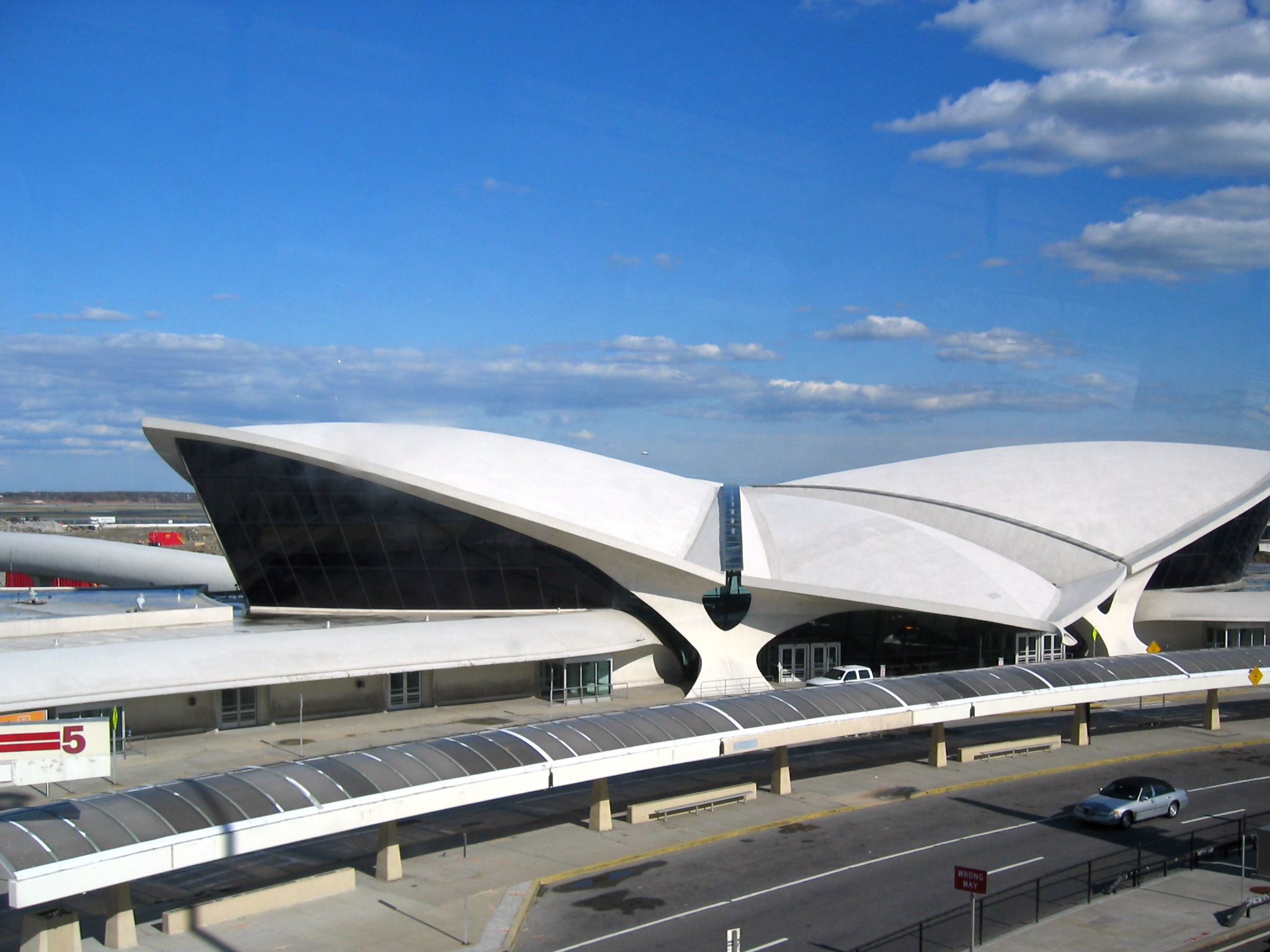
40°44′49″N 73°55′3″W / 40.74694°N 73.9175°WSunnyside Gardens 80 Trans World Airlines Flight Center 
September 7, 2005 John F. Kennedy International Airport
40°38′44.86″N 73°46′39.27″W / 40.6457944°N 73.777575°WJamaica Designed by Eero Saarinen 81 Trinity Chapel January 11, 2002 1874 Mott Avenue
40°36′13″N 73°45′5″W / 40.60361°N 73.75139°WFar Rockaway 82 Trinity Lutheran Church May 29, 2008 31-18 37th St.
40°45′42.31″N 73°55′9.2″W / 40.7617528°N 73.919222°WAstoria (new listing, refnum 08000471) 83 US Post Office-Far Rockaway November 17, 1988 18-36 Mott Avenue
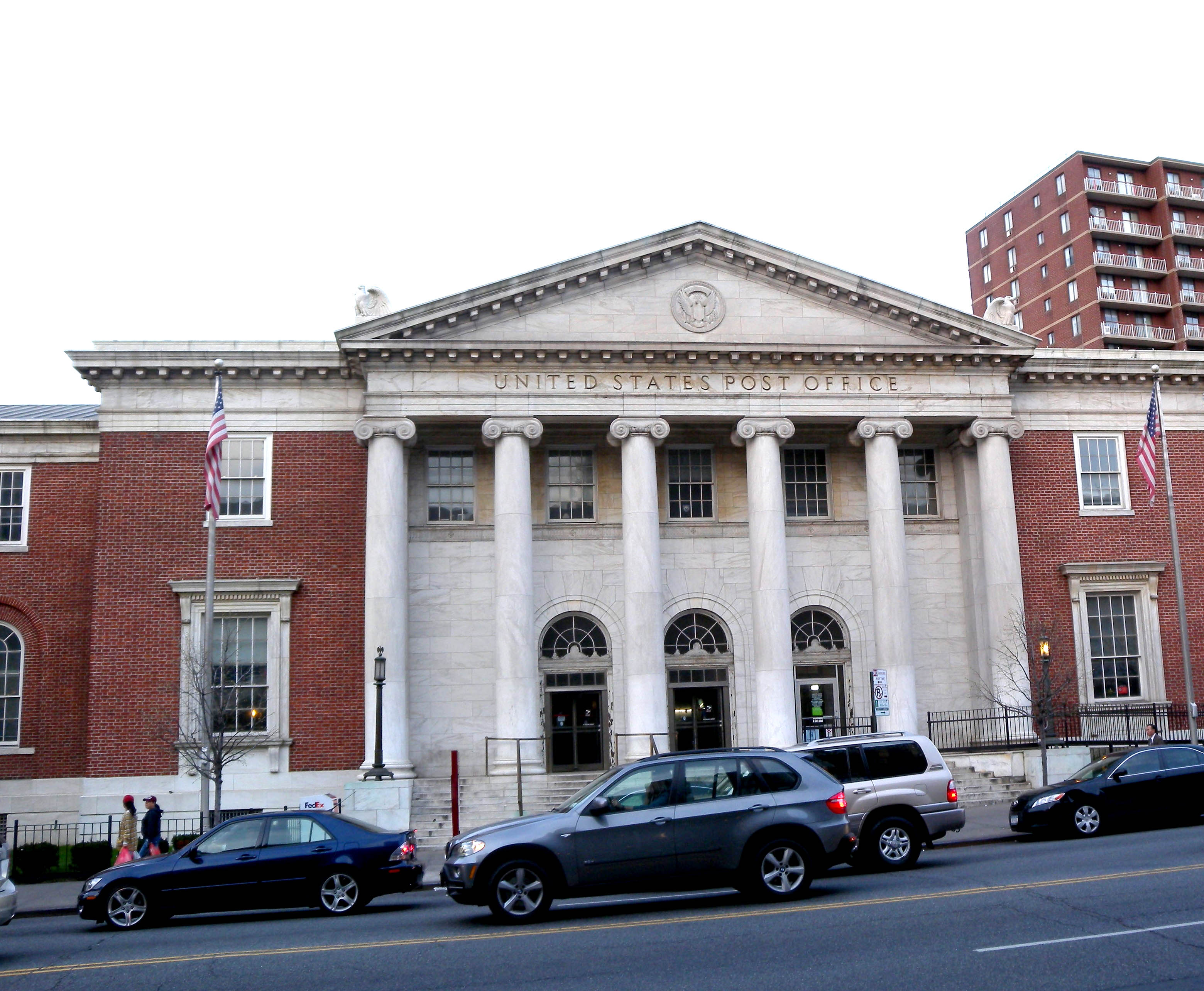
40°36′12″N 73°45′3″W / 40.60333°N 73.75083°WFar Rockaway 84 US Post Office-Flushing Main 
November 17, 1988 41-65 Main St.
40°45′33″N 73°49′43″W / 40.75917°N 73.82861°WFlushing 85 US Post Office-Forest Hills Station 
November 17, 1988 106-28 Queens Blvd.
40°43′18″N 73°50′50″W / 40.72167°N 73.84722°WForest Hills 86 US Post Office-Jackson Heights Station November 17, 1988 78-02 37th Ave.
40°44′57″N 73°53′16″W / 40.74917°N 73.88778°WJackson Heights 87 US Post Office-Jamaica Main November 17, 1988 88-40 164th St.
40°45′40″N 73°48′8″W / 40.76111°N 73.80222°WJamaica 88 US Post Office-Long Island City 
May 11, 1989 46-02 21st St.
40°44′44″N 73°56′57″W / 40.74556°N 73.94917°WLong Island City 89 Cornelius Van Wyck House October 6, 1983 37-04 Douglaston Parkway
40°46′23″N 73°45′12″W / 40.77306°N 73.75333°WDouglaston 90 Vander Ende-Onderdonk House Site 
January 31, 1977 1820 Flushing Ave.
40°42′40″N 73°55′12″W / 40.71111°N 73.92°WRidgewood 91 Woodbine-Palmetto-Gates Historic District September 30, 1983 Roughly bounded by Forest and Fairview Aves., Woodbine and Linden Sts.
40°42′25″N 73°54′15″W / 40.70694°N 73.90417°WMiddle Village 92 Wyckoff-Snediker Family Cemetery May 25, 2001 85-45 96th St.
40°41′46″N 73°50′57″W / 40.69611°N 73.84917°WWoodhaven notes having info to be merged into table above
- Neighborhoods reflected in earlier version here: capture the neighborhoods
- Roxbury
- Fort Tilden Historic District
- New York Avenue NY
See also
- Statewide: National Register of Historic Places listings in New York
- Citywide: Manhattan, Brooklyn, Staten Island, Bronx
- List of New York City Designated Landmarks in Queens
References
- ^ The latitude and longitude information provided in this table was derived originally from the National Register Information System, which has been found to be fairly accurate for about 99% of listings. For about 1% of NRIS original coordinates, experience has shown that one or both coordinates are typos or otherwise extremely far off; some corrections may have been made. A more subtle problem causes many locations to be off by up to 150 yards, depending on location in the country: most NRIS coordinates were derived from tracing out latitude and longitudes off of USGS topographical quadrant maps created under North American Datum of 1927, which differs from the current, highly accurate GPS system used by Google maps. Chicago is about right, but NRIS longitudes in Washington are higher by about 4.5 seconds, and are lower by about 2.0 seconds in Maine. Latitudes differ by about 1.0 second in Florida. Some locations in this table may have been corrected to current GPS standards.
- ^ "National Register of Historic Places: Weekly List Actions". National Park Service, United States Department of the Interior. Retrieved on November 18, 2011.
Neighborhoods in the New York City Borough of Queens Arverne · Astoria · Astoria Heights · Auburndale · Bayside · Bayswater · Bay Terrace · Beechhurst · Bellaire · Belle Harbor · Bellerose · Blissville · Boulevard Gardens · Breezy Point · Briarwood · Broad Channel · Broadway-Flushing · Cambria Heights · College Point · Corona · Ditmars · Douglaston · Dutch Kills · East Elmhurst · Edgemere · Electchester · Elmhurst · Far Rockaway · Floral Park · Flushing · Forest Hills · Forest Hills Gardens · Fresh Meadows · Fresh Pond · Glendale · Glen Oaks · Hamilton Beach · Hammels · Hillcrest · Hollis · Hollis Hills · Holliswood · Howard Beach · Howard Park · Hunters Point · Jackson Heights · Jamaica · Jamaica Estates · Jamaica Hills · Kew Gardens · Kew Gardens Hills · Laurelton · LeFrak City · Linden Hill · Lindenwood · Little Neck · Locust Manor · Long Island City · Malba · Maspeth · Meadowmere · Middle Village · Murray Hill · Neponsit · North Corona · North Shore Towers · Oakland Gardens · Old Howard Beach · Ozone Park · Pomonok · Queensboro Hill · Queensbridge · Queens Village · Ramblersville · Ravenswood · Rego Park · Richmond Hill · Ridgewood · Rochdale · Rockaway · Rockaway Beach · Rockaway Park · Rockwood Park · Rosedale · Roxbury · St. Albans · Seaside · South Jamaica · South Ozone Park · Springfield Gardens · Sunnyside · Sunnyside Gardens · Tudor Village · Utopia · Warnerville · Whitestone · Willets Point · Woodhaven · Woodside · Wyckoff Heights

Community Boards: 1 · 2 · 3 · 4 · 5 · 6 · 7 · 8 · 9 · 10 · 11 · 12 · 13 · 14 Categories:- National Register of Historic Places in New York by county
- National Register of Historic Places in New York City
- Buildings and structures in Queens
-


Wikimedia Foundation. 2010.