- Nantglyn
-
Nantglyn is a small village in Denbighshire, Wales. It is situated in a picturesque rural location about 4.5 miles (7.2 km) away from the nearest town, Denbigh. There are several other small villages in the area.
Amenities
While there are now no shops remaining in Nantglyn, it previously maintained a blacksmith's forge, a post office, a pub and a leather-craft shop that also sold candles (located in the old smithy). There was also a local infant / junior school, but a decline in the number of pupils led to its closure in the 1990s. A memorial to the fallen of the two World Wars sits at the centre of the village.
The parish church is dedicated to St James. It is probably quite old but was extensively renovated in 1777 and again in Victorian times. A notable feature of its churchyard is the "pulpit in a tree" built into an ancient yew. Tradition has it that it was used by John Wesley to preach from during the 18th century, although it would seem unlikely that a Methodist minister would be allowed to preach in an Anglican churchyard. There were also several Nonconformist chapels in the village, including Capel-y-Waen (Waen Nantglyn is a secondary settlement about a mile northwest of the main village), Capel Soar and Capel Salem.
Nantglyn is located on a small river, the Lliwen. This river and its parent, the Afon Ystrad, provided the water to power several corn and fulling mills in the parish. One of the corn mills, Segrwyd Mill, served the neighbourhood farmers until 1960.
Notable residents
Nantglyn has had several notable residents over the centuries, including David Samwell (1751–98), the ship's surgeon aboard the Discovery during Captain Cook's final voyage of exploration. Samwell kept a journal that provides a detailed record of the voyage, and he witnessed Cook's death at the hands of hostile natives in Hawaii in 1779. Dr. William Owen Pughe (1759–1835), a well-known literary figure who compiled a Welsh-English dictionary and a Welsh grammar, among other works, lived in the village for the last 10 years of his life, although he was not born there.
External links
Denbighshire Principal settlements 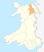
Towns and villages Aberwheeler · Berwyn · Betws Gwerfil Goch · Bodelwyddan · Bodfari · Bontuchel · Bryneglwys · Bylchau · Carrog · Castell · Cefnmeriadog · Cerrigydrudion · Clocaenog · Corwen · Crogen · Cwm · Cyffylliog · Cynwyd · Derwen · Druid · Dyserth · Efenechtyd · Gellifor · Gellioedd · Glasfryn · Glyndyfrdwy · Gronant · Gwaenysgor · Gwyddelwern · Henllan · Hirwaen · Llanarmon-yn-Iâl · Llanbedr-Dyffryn-Clwyd · Llandegla · Llandrillo · Llandyrnog · Llanefydd · Llanelidan · Llanferres · Llanfwrog · Llangar · Llangwyfan · Llangyhafal · Llanrhaeadr-yng-Nghinmeirch · Llansanffraid Glyndyfrdwy · Llantysilio · Llanychan · Llanynys · Llwynmawr · Maerdy · Meliden · Nantglyn · Prion · Pentrecelyn · Rhewl · Rhuallt · Saron · Tafarn Y Gelyn · Trefnant · Trelawnyd · Tremeirchion
Oldest inhabited location Moors Categories:- Villages in Denbighshire

Wikimedia Foundation. 2010.