- Corbridge
-
Coordinates: 54°58′30″N 2°01′01″W / 54.975°N 2.017°W
Corbridge 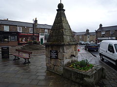
Market Place, Corbridge town centre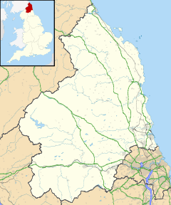
 Corbridge
Corbridge shown within NorthumberlandPopulation 3,500 OS grid reference NY990646 Shire county Northumberland Region North East Country England Sovereign state United Kingdom Post town CORBRIDGE Postcode district NE45 Dialling code 01434 Police Northumbria Fire Northumberland Ambulance North East EU Parliament North East England UK Parliament Hexham List of places: UK • England • Northumberland Not to be confused with Cobridge.Corbridge is a village in Northumberland, England, situated 16 miles (26 km) west of Newcastle and 4 miles (6 km) east of Hexham. Villages in the vicinity include Halton, Acomb, Aydon and Sandhoe.
Contents
History
Roman fort and town
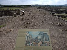 The Stanegate, Corbridge Roman Site
 Main article: Coria (Corbridge)
Known to the Romans as something like Corstopitum or Coriosopitum, wooden writing tablets found at Vindolanda suggest it was probably locally called Coria (meaning a tribal centre), it was the most northerly town in the Roman Empire, lying at the junction of Stanegate and Dere Street.
The first fort was established c. AD 85, although there was a slightly earlier base nearby at Beaufront Red House. By the middle of the 2nd century AD, the fort was replaced by a town with two walled military compounds, which were garrisoned until the end of the Roman occupation of the site. The best-known finds from the site include the stone Corbridge Lion and the Corbridge Hoard of armour and sundry other items. In Rudyard Kipling's Puck of Pook's Hill, the town of Hunno on the Wall, is probably based on Corstopitum.
Buildings
 St. Andrew's Church
The Church of England parish church of St. Andrew is thought to have been consecrated in 676. St Wilfrid is supposed to have built the church at the same time as Hexham Abbey was constructed. It has been altered several times throughout the centuries, with a Norman doorway still in evidence, as well as a lych gate constructed in memory of the soldiers killed in the First World War.
There are only three fortified vicarages in the county, and one of these is in Corbridge. Built in the 14th century, the Vicar's Pele is to be found in the south-east corner of the churchyard, and has walls 1.3 metres (4 ft) in thickness. The register for St. Andrews dates from 1657. Later on in the town's ecclesiastical history, Wesleyan, Primitive and Free Methodist chapels were all built too.
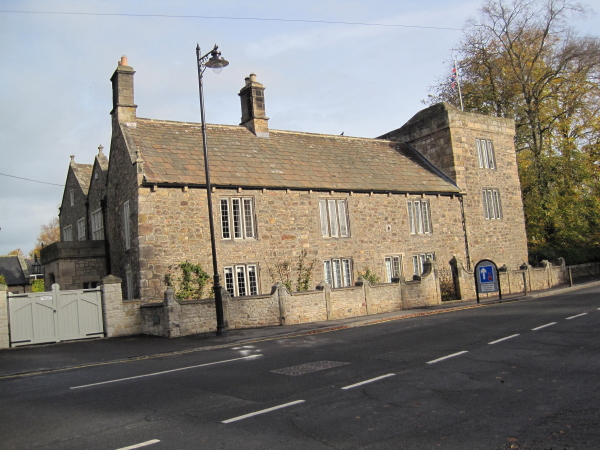
 Corbridge Low Hall
Even older than the Vicar's Pele is Corbridge Low Hall, dating from the late 13th or early 14th century with one end converted to a pele tower in the 15th century. The main block was remodelled in the 16th and 17th centuries, and the building restored c1890.[1]
Border warfare
Corbridge suffered, as did many other settlements in the county, from the border warfare which was particularly prevalent between 1300 and 1700. Raids were commonplace, and it was not unusual for the livestock to be brought into the town at night and a watch placed to guard either end of the street for marauders. A bridge over the Tyne was built in the 13th century, but this original has not survived. The present bridge, an impressive stone structure with seven arches, was erected in 1674.
Governance
Corbridge is in the parliamentary constituency of Hexham.
Transport
- Road
Corbridge is bypassed to the north by the A69 road, linking it to Newcastle and Carlisle. It is also linked to Newcastle and the A1 by the A695 which passes about 1 mile (1.6 km) away on the south side of the River Tyne.
- Railway
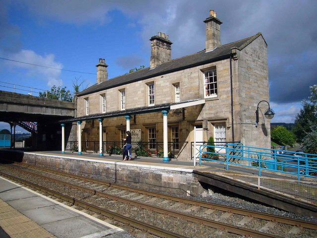
 Corbridge railway station
The town is served by Corbridge railway station on the Newcastle and Carlisle Railway, also known as the Tyne Valley Line. The line was opened in 1838, and links the city of Newcastle upon Tyne in Tyne and Wear with Carlisle in Cumbria. The line follows the course of the River Tyne through Northumberland.
Passenger services on the Tyne Valley Line are operated by Northern Rail and First ScotRail. The line is also heavily used for freight.
The railway station is about 1 mile (1.6 km) away on the south side of the River Tyne.
Fairs and shows
Stagshaw Bank Fair, traditionally held on 4 July, was one of the most famous of the country fairs. It included a huge sale of stock, and was proclaimed each year by the bailiff to the Duke of Northumberland. Today the Northumberland County Show, an agricultural event, is held in the fields outside Corbridge each year, a very popular rural event, drawing people from all over Northumberland as well as further afield.
Fastlane Show
The Fastlane show is a supercar show which exibis supercars from around the world.
Corbridge Steam Fair and Vintage Rally
The Corbridge Steam Fair and Vintage Rally is held every year in June to celebrate steam engines. There are also classic cars, trucks and tractors.
Notable people
- Ruth Ainsworth (1908–1984), children's writer of the Rufty Tufty Golliwog series
- John Blackburn (1923–1993), thriller writer
- Born at Corbridge
- Alan Brown (footballer) (1914–1996), professional footballer and manager
- Steve Bruce (born 1960), English football manager
- Resided at Corbridge
- Catherine Cookson (1906–1998), author
References
External links
- Vicar's Pele Tower
- Corbridge's river crossings
- Stagshaw Bank Fair
- Northumberland County Show
- Corstopitum
- Corbridge Parish Council
- GENUKI (Accessed: 10 November 2008)
- Northumberland Communities (Accessed: 10 November 2008)
- Roman empire.net article on Roman Corbridge
Unitary authorities Major settlements Alnwick · Amble · Ashington · Bedlington · Berwick-upon-Tweed · Blyth · Cramlington · Haltwhistle · Hexham · Morpeth · Newbiggin-by-the-Sea · Prudhoe · Rothbury · Wooler
See also: List of civil parishes in NorthumberlandTopics Categories:- Northumberland articles missing image alternative text
- Villages in Northumberland
- 80s establishments


Wikimedia Foundation. 2010.