California State Route 282
- California State Route 282
Infobox road
state=CA
type=SR
route=282
section=582
maint=Caltrans
length_mi=0.6
length_round=1
length_ref= [ [http://www.dot.ca.gov/hq/structur/strmaint/brlog2.htm January 1, 2006 California Log of Bridges on State Highways] ]
direction_a=West
terminus_a=NAS North Island
direction_b=East
terminus_b=jct|state=CA|SR|75 in Coronado
previous_type=SR
previous_route=281
next_type=SR
next_route=283
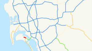
State Route 282 is a state highway within Coronado, California. It is a spur from State Route 75, connecting traffic from the Naval Air Station at North Island mainly towards the San Diego-Coronado Bay Bridge north on SR 75.
External links
* [http://www.dot.ca.gov/hq/roadinfo/sr282 Caltrans: Route 282 highway conditions]
* [http://cahighways.org/281-288.html#282 California Highways: Route 282]
* [http://www.westcoastroads.com/california/ca-282.html AARoads: State Route 282]
References
Wikimedia Foundation.
2010.
Look at other dictionaries:
California State Route 282 — Karte … Deutsch Wikipedia
California State Route 75 — Karte … Deutsch Wikipedia
California State Route 149 — State Route 149 Route information … Wikipedia
California State Route 70 — Infobox road state=CA type=SR route=70 section=370 maint=Caltrans length mi=178.528 length ref= length round=3 length notes=(plus about 0.5 mi (1 km) on SR 20) history=State highway in 1910 and 1931; became SR 24 in 1934, US 40A in 1954, and SR… … Wikipedia
California State Route 283 — Infobox road state=CA type=SR route=283 section=583 maint=Caltrans length mi=0.36 length ref= [ [http://www.dot.ca.gov/hq/structur/strmaint/brlog2.htm January 1, 2006 California Log of Bridges on State Highways] ] length round=2 established=1970… … Wikipedia
California State Route 75 — Infobox road state=CA type=SR route=75 section=375 maint=Caltrans length mi=13 length round=0 length ref= [http://www.dot.ca.gov/hq/structur/strmaint/brlog2.htm January 1, 2006 California Log of Bridges on State Highways] ] direction a=South… … Wikipedia
California State Route 281 — Infobox road state=CA type=SR route=281 section=581 maint=Caltrans length mi=17 length round=0 length ref= [ [http://www.dot.ca.gov/hq/structur/strmaint/brlog2.htm January 1, 2006 California Log of Bridges on State Highways] ] direction a=West… … Wikipedia
Nevada State Route 512 — State Route 512 Kings Canyon Road, King Street; Division Street, W. Fifth Street Route information Length: 2.282 mi … Wikipedia
California Freeway and Expressway System — The California Freeway and Expressway System is a system of existing or planned freeways and expressways in the U.S. state of California. It is defined by the Streets and Highways Code.List of roads in the system*State Route 1 (part) *State Route … Wikipedia
California's 1st congressional district — This page is about California s 1st congressional district. You may be looking for California State Route 1. Infobox U.S. congressional district state = California district number = 1 representative = Mike Thompson party = Democratic english area … Wikipedia
