- National Register of Historic Places listings in Allegheny County, Pennsylvania
-
 Location of Allegheny County in Pennsylvania
This is a list of the National Register of Historic Places listings in Allegheny County, Pennsylvania.
This is intended to be a complete list of the properties and districts on the National Register of Historic Places in Allegheny County, Pennsylvania, excluding the city of Pittsburgh. The locations of National Register properties and districts for which the latitude and longitude coordinates are included below, may be seen in a Google map.[1]
There are 212 properties and districts listed on the National Register in the county, including 10 National Historic Landmarks. Pittsburgh is the location of 152 of these properties and districts, including 5 National Historic Landmarks; they are listed separately. The 62 properties and districts elsewhere in the county, including 5 National Historic Landmarks, are listed here. Two properties are split between Pittsburgh and other parts of the county.
-
- This National Park Service list is complete through NPS recent listings posted November 10, 2011.[2]
Current listings
[3] Landmark name[4] Image Date listed Location Municipality Summary 1 Allegheny River Lock and Dam No. 3 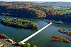
April 21, 2000 Approximately 1 mile (1.6 km) north of Barrington
40°32′18″N 79°48′13″W / 40.53833°N 79.80361°WHarmar Township and Plum 2 Allegheny River Lock and Dam No. 4 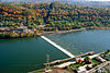
April 21, 2000 1 River Avenue
40°36′52″N 79°42′59″W / 40.61444°N 79.71639°WHarrison Township Extends into Lower Burrell in Westmoreland County 3 Beulah Presbyterian Church 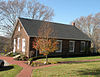
November 3, 1975 Beulah and McCrady Roads
40°26′49.2″N 79°50′53.92″W / 40.447°N 79.8483111°WChurchill 4 Bost Building 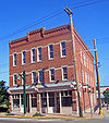
January 20, 1999 621–623 East 8th Avenue
40°24′32.8278″N 79°54′15.699″W / 40.409118833°N 79.90436083°WHomestead Headquarters of the Amalgamated Association of Iron and Steel Workers during the 1892 Homestead Strike 5 Bowman Homestead 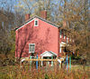
September 7, 1979 North of McKeesport at 3500 The Lane
40°22′14.1″N 79°49′30.56″W / 40.370583°N 79.8251556°WNorth Versailles Township 6 Boyce Station 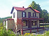
November 14, 1982 1050 Boyce Road
40°19′5″N 80°6′50″W / 40.31806°N 80.11389°WUpper St. Clair Township Intact example of turn-of-century train station that served as local commercial center 7 Bridge in Jefferson Borough 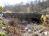
June 22, 1988 Cochran Mill Road over Lick Run
40°17′34.48″N 79°58′12.75″W / 40.2929111°N 79.9702083°WJefferson Hills and South Park Township 8 Bridge in Shaler Township 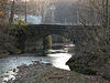
June 22, 1988 Birchfield Road over Pine Creek
40°32′42.03″N 79°57′45.49″W / 40.5450083°N 79.9626361°WShaler Township 9 Burtner Stone House 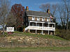
January 13, 1972 Northwest of Natrona Heights on Burtner Road
40°37′52.93″N 79°43′50.95″W / 40.6313694°N 79.7308194°WHarrison Township 10 Campbell Building 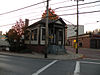
September 19, 1988 3 Crafton Square
40°26′8.16″N 80°3′54″W / 40.4356°N 80.065°WCrafton 11 Carnegie Free Library 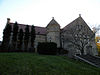
October 15, 1980 1507 Liberty Avenue
40°20′43.37″N 79°51′18.74″W / 40.3453806°N 79.8552056°WMcKeesport 12 Carnegie Free Library of Braddock 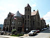
June 19, 1973 419 Library Street
40°24′6.73″N 79°51′55.53″W / 40.4018694°N 79.865425°WBraddock 13 Andrew Carnegie Free Library 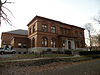
October 8, 1981 300 Beechwood Avenue
40°24′24.72″N 80°5′9.08″W / 40.4068667°N 80.0858556°WCarnegie 14 Carrie Blast Furnace Number 6 and 7 
September 20, 2006 Northern side of the Monongahela River, 0.5 miles (0.80 km) west of the Rankin Bridge
40°24′47.09″N 79°53′24.28″W / 40.4130806°N 79.8900778°WMunhall, Rankin, and Swissvale Only remainder of once-vast Homestead Steel Works 15 Rachel Carson House 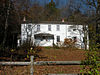
October 22, 1976 613 Marion Avenue
40°32′47.15″N 79°47′0.07″W / 40.5464306°N 79.7833528°WSpringdale Childhood home of author Rachel Carson 16 Coraopolis Armory 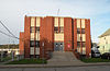
November 14, 1991 835 5th Avenue
40°31′10.0344″N 80°10′7.8204″W / 40.519454°N 80.168839°WCoraopolis 17 Coraopolis Bridge 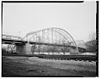
January 7, 1986 Ohio River Back Channel at Ferree Street and Grand Avenue
40°30′58″N 80°9′7″W / 40.51611°N 80.15194°WCoraopolis and Neville Township 18 Coraopolis Railroad Station 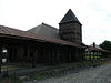
April 20, 1979 Neville Avenue and Mill Street
40°31′8.04″N 80°9′49.32″W / 40.5189°N 80.1637°WCoraopolis 19 Davis Island Lock and Dam Site 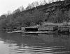
August 29, 1980 Off Pennsylvania Route 65
40°29′35″N 80°3′56″W / 40.49306°N 80.06556°WAvalon 20 Elmridge 
May 10, 2005 Beaver Road at Camp Meeting Road
40°33′49.49″N 80°12′15.2″W / 40.5637472°N 80.204222°WLeetsdale 21 Evergreen Hamlet 
September 17, 1974 Evergreen Hamlet Road
40°30′29.41″N 79°59′39.23″W / 40.5081694°N 79.9942306°WRoss Township 22 Experimental Mine, U.S. Bureau of Mines 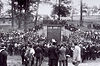
October 18, 1974 South of Bruceton off Cochran Mill Road
40°18′18.08″N 79°58′51.49″W / 40.3050222°N 79.9809694°WSouth Park Township 23 Fortieth Street Bridge 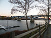
June 22, 1988 40th Street over the Allegheny River
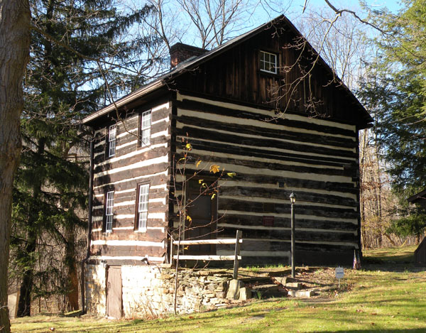
40°28′25″N 79°58′12″W / 40.47361°N 79.97°WMillvale Extends into Pittsburgh 24 Fulton Log House 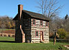
December 6, 1975 Southwest of Pittsburgh on Clifton–Bridgeville Road off U.S. Route 19
40°19′58.8″N 80°4′14.36″W / 40.333°N 80.0706556°WUpper St. Clair Township 25 Gardner-Bailey House 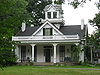
October 1, 1974 124 West Swissvale Avenue
40°25′55″N 79°53′12″W / 40.43194°N 79.88667°WEdgewood 26 Gilfillan Farm 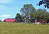
November 20, 1979 1950 Washington Road
40°20′32″N 80°3′52″W / 40.34222°N 80.06444°WUpper St. Clair Township Mid-19th century farm still working amid modern suburban development (now partially a county park); main house shows transition between Greek Revival and Victorian architectural styles 27 Hamnett Historic District 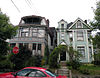
June 28, 2010 Roughly bounded by Rebecca Ave., rear property lines on the east side of Center St., Sewer Way, Lytle Way, and the Norfolk Southern RR right-of-way
40°26′23″N 79°53′1″W / 40.43972°N 79.88361°WWilkinsburg 28 Homestead Historic District 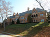
May 10, 1990 8th Avenue area roughly bounded by Mesta, 6th, Andrew, 11th, and Walnut Streets and Doyle and 7th Avenues
40°24′17″N 79°54′27″W / 40.40472°N 79.9075°WHomestead, Munhall, and West Homestead 29 Homestead Pennsylvania Railroad Station 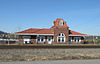
December 26, 1985 Amity Street
40°24′28.76″N 79°54′44.82″W / 40.4079889°N 79.91245°WHomestead 30 Hutchinson Farm 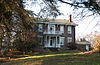
February 19, 1986 Round Hill Road at Pennsylvania Route 51
40°14′23.05″N 79°51′53.86″W / 40.2397361°N 79.8649611°WElizabeth Township 31 Jerome Street Bridge 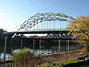
June 22, 1988 5th Avenue over the Youghiogheny River
40°21′1.8″N 79°52′11.84″W / 40.3505°N 79.8699556°WMcKeesport[5] 32 Kennywood Park 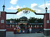
February 27, 1987 4800 Kennywood Boulevard
40°23′15″N 79°51′48″W / 40.3875°N 79.86333°WWest Mifflin Only large remaining U.S. "trolley" amusement park 33 Dr. Thomas R. Kerr House and Office 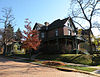
September 2, 2003 438 4th Street
40°31′2″N 79°50′26″W / 40.51722°N 79.84056°WOakmont 34 Lehner Grain-and-Cider Mill and House 
October 24, 1996 548 and 560 Penn Street
40°30′13.2″N 79°50′45.5″W / 40.503667°N 79.845972°W[6]Verona 35 Isaac Lightner House 
April 20, 1978 2407 Mt. Royal Boulevard
40°32′15″N 79°58′21.65″W / 40.5375°N 79.9726806°WShaler Township 36 Lobb's Cemetery and Yohogania County Courthouse Site 
November 12, 1992 Calamity Hollow Road at Lobb's Run
40°15′46.41″N 79°54′57.77″W / 40.2628917°N 79.9160472°WJefferson Hills 37 Logans Ferry Powder Works Historic District 
May 7, 1998 Barking Road
40°32′17.35″N 79°45′55.9″W / 40.5381528°N 79.765528°WPlum 38 Longfellow School 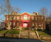
June 28, 1984 Monroe Street and McClure Avenue
40°25′20.11″N 79°53′30.2″W / 40.4222528°N 79.891722°WSwissvale 39 Longue Vue Club and Golf Course 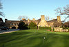
May 10, 2005 400 Longue Vue Drive, Verona
40°28′51.92″N 79°51′31.1″W / 40.4810889°N 79.858639°WPenn Hills Township 40 McKees Rocks Bridge 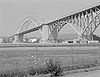
November 14, 1988 Legislative Route 76, Spur 2, over the Ohio River at McKees Rocks
40°28′37.344″N 80°2′56.04″W / 40.47704°N 80.0489°WMcKees Rocks and Stowe Township Extends into Pittsburgh 41 McKeesport National Bank 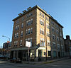
August 29, 1980 5th Avenue and Sinclair Street
40°21′3.83″N 79°51′42.84″W / 40.3510639°N 79.8619°WMcKeesport 42 James Miller House 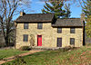
January 17, 1975 East of Bethel on Manse Drive
40°19′12.29″N 80°0′23.47″W / 40.3200806°N 80.0065194°WSouth Park Township On the site of the Oliver Miller Homestead, first settled in 1772. In 1794, the first fired gunshots of the Whiskey Rebellion occurred on the property. In 1830, the log house was replaced with a large stone section, making it the "Stone Manse" house as it stands today. 43 MISSISSIPPI III 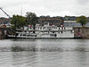
September 21, 1983 Neville Island
40°30′44″N 80°7′12″W / 40.51222°N 80.12°WNeville Township The last of the Texas-deck sternwheelers, Showboat Becky Thatcher relocated from Marietta, Ohio, in October 2009.[7] On the night of February 19, 2010, the Becky Thatcher sank at its mooring on Neville Island in the Ohio River.[8] Demolition of the boat began on Monday, March 8, 2010.[9] 44 Oakdale Public School 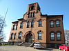
March 28, 1997 33 Hastings Street
40°23′53.88″N 80°10′59.88″W / 40.3983°N 80.1833°WOakdale 45 Oakmont Country Club Historic District 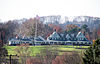
August 17, 1984 Hulton Road
40°31′32.73″N 79°49′36.35″W / 40.5257583°N 79.8267639°WPlum Oldest top-ranked golf course in the United States, designed by Henry Fownes and Edward Stotz in 1903 46 Pennsalt Historic District 
July 18, 1985 Roughly bounded by Federal, Penn, and Pond Streets, and Philadelphia and Blue Ridge Avenues, in Natrona
40°36′52.9″N 79°43′16.72″W / 40.614694°N 79.7213111°WHarrison Township Former company town of the Pennsylvania Salt Manufacturing Company 47 Pennsylvania Railroad Station-Wilkinsburg 
July 18, 1985 Hay Street at Ross Avenue
40°26′35″N 79°53′17″W / 40.44306°N 79.88806°WWilkinsburg 48 Reed Hall 
November 28, 1980 West of Emsworth on Huntington Road
40°30′57″N 80°6′44″W / 40.51583°N 80.11222°WKilbuck Township Reed Hall was part of the former Dixmont State Hospital, which opened in 1862. Architect: Joseph W. Kerr (1815–1888).[10] The entire hospital, including Reed Hall, was demolished in 2006.[10] 49 St. Nicholas Croatian Church 
May 6, 1980 24 Maryland Avenue
40°28′37.36″N 79°58′10.88″W / 40.4770444°N 79.9696889°WMillvale 50 Sauer Buildings Historic District 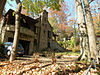
September 11, 1985 607–717 Center Avenue
40°29′41.28″N 79°54′12.71″W / 40.4948°N 79.9035306°WAspinwall The buildings in this district were designed by Frederick C. Sauer (1860–1942), from around 1900 until his death in 1942. 51 David Shields House 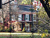
October 29, 1975 Shields Lane
40°33′25.34″N 80°11′59.14″W / 40.5570389°N 80.1997611°WEdgeworth 52 John F. Singer House 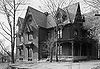
November 13, 1974 1318 Singer Place
40°26′48″N 79°52′56″W / 40.44667°N 79.88222°WWilkinsburg 53 Sperling Building 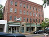
May 10, 2005 1007–1013 Penn Avenue
40°26′38″N 79°52′45″W / 40.44389°N 79.87917°WWilkinsburg 54 Thornburg Historic District 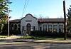
December 8, 1982 Off Pennsylvania Route 60
40°25′56.97″N 80°4′59.76″W / 40.4324917°N 80.0832667°WThornburg 55 Turtle Creek High School 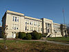
August 30, 2007 126 Monroeville Avenue
40°24′18″N 79°49′26″W / 40.405°N 79.82389°WTurtle Creek 56 Van Kirk Farm 
February 19, 1986 Round Hill Road at Scenery Drive
40°14′27.7″N 79°51′43.09″W / 40.241028°N 79.8619694°WElizabeth Township 57 Walker-Ewing Log House 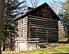
January 30, 1976 Northeast of Oakdale on Noblestown Road
40°24′40.29″N 80°9′36.39″W / 40.4111917°N 80.1601083°WCollier Township Log house built circa 1790 58 Nicholas Way House 
September 13, 1978 108 Beaver Road
40°32′51.07″N 80°11′18.64″W / 40.5475194°N 80.1885111°WEdgeworth 59 Westinghouse Air Brake Company General Office Building 
March 6, 1987 Marguerite and Bluff Streets
40°23′31.64″N 79°48′26.64″W / 40.3921222°N 79.8074°WWilmerding Built in 1890, this building contained the offices of the Westinghouse Air Brake Company, founded by George Westinghouse. 60 George Westinghouse Memorial Bridge 
March 28, 1977 U.S. Route 30 at Turtle Creek
40°23′38″N 79°50′16″W / 40.39389°N 79.83778°WEast Pittsburgh and North Versailles Township 61 Wilpen Hall April 20, 2011 889–895 Blackburn Road and 201 Scaife Road
40°32′52″N 80°9′5″W / 40.54778°N 80.15139°WSewickley Heights 62 Woodville 
February 5, 1974 South of Heidelberg on Pennsylvania Route 50
40°22′47″N 80°5′47″W / 40.37972°N 80.09639°WCollier Township 1785 home of John Neville, tax collector targeted by the Whiskey Rebels. Preserved and restored to near-original condition; today one of the oldest houses in the county. Former listing
[3] Landmark name[4] Image Date delisted Location City or Town Summary 1 Linden Grove 
January 20, 2000 Grove Road at Library Road and Willow Avenue Castle Shannon See also
- National Register of Historic Places listings in Pennsylvania
- National Register of Historic Places listings in Pittsburgh, Pennsylvania
- List of National Historic Landmarks in Pennsylvania
- List of City of Pittsburgh historic designations
- List of Pittsburgh History and Landmarks Foundation Historic Landmarks
- List of Pennsylvania state historical markers in Allegheny County
References
- ^ The latitude and longitude information provided in this table was derived originally from the National Register Information System, which has been found to be fairly accurate for about 99% of listings. For about 1% of NRIS original coordinates, experience has shown that one or both coordinates are typos or otherwise extremely far off; some corrections may have been made. A more subtle problem causes many locations to be off by up to 150 yards, depending on location in the country: most NRIS coordinates were derived from tracing out latitude and longitudes off of USGS topographical quadrant maps created under North American Datum of 1927, which differs from the current, highly accurate GPS system used by Google maps. Chicago is about right, but NRIS longitudes in Washington are higher by about 4.5 seconds, and are lower by about 2.0 seconds in Maine. Latitudes differ by about 1.0 second in Florida. Some locations in this table may have been corrected to current GPS standards.
- ^ "National Register of Historic Places: Weekly List Actions". National Park Service, United States Department of the Interior. Retrieved on November 10, 2011.
- ^ a b Numbers represent an ordering by significant words. Various colorings, defined here, differentiate National Historic Landmark sites and National Register of Historic Places Districts from other NRHP buildings, structures, sites or objects.
- ^ a b "NPS Focus". National Register of Historic Places. National Park Service. http://nrhp.focus.nps.gov. Retrieved November 20, 2009.
- ^ Both sides of the Jerome Street Bridge touch down in McKeesport, PA, and not in Glassport according to the Allegheny County Municipal Map
- ^ Location derived from its NRHP nomination form; the NRIS lists the site as "Address Restricted"
- ^ Majors, Dan (October 14, 2009). "Riverboat owner to float restaurant idea on river here". Pittsburgh, Pennsylvania: Pittsburgh Post-Gazette. http://www.post-gazette.com/pg/09287/1005260-455.stm. Retrieved October 20, 2009.
- ^ "Sunk!: Reason Becky Thatcher took on water not known". Parkersburg News and Sentinel 2010-02-22. http://www.newsandsentinel.com/page/content.detail/id/526900.html?nav=5061.
- ^ Dennis B. Roddy, "Crews begin demolishing historic ship on Ohio River", Pittsburgh Post-Gazette, Tuesday, March 09, 2010.
- ^ a b Sewickley Valley Historical Society Signals, XXXIII, Number 5, February 2006. Architect J. W. Kerr Leaves His Mark: Western Pennsylvania's Prolific Architect, W. Brewster Cockrell. Retrieved on November 19, 2009.
Municipalities and communities of Allegheny County, Pennsylvania Cities Clairton | Duquesne | McKeesport | Pittsburgh

Boroughs Aspinwall | Avalon | Baldwin | Bell Acres | Bellevue | Ben Avon | Ben Avon Heights | Bethel Park | Blawnox | Brackenridge | Braddock | Braddock Hills | Bradford Woods | Brentwood | Bridgeville | Carnegie | Castle Shannon | Chalfant | Cheswick | Churchill | Coraopolis | Crafton | Dormont | Dravosburg | East McKeesport | East Pittsburgh | Edgewood | Edgeworth | Elizabeth | Emsworth | Etna | Forest Hills | Fox Chapel | Franklin Park | Glassport | Glen Osborne | Glenfield | Green Tree | Haysville | Heidelberg | Homestead | Ingram | Jefferson Hills | Leetsdale | Liberty | Lincoln | McDonald‡ | McKees Rocks | Millvale | Monroeville | Mount Oliver | Munhall | North Braddock | Oakdale | Oakmont | Pennsbury Village | Pitcairn | Pleasant Hills | Plum | Port Vue | Rankin | Rosslyn Farms | Sewickley | Sewickley Heights | Sewickley Hills | Sharpsburg | Springdale | Swissvale | Tarentum | Thornburg | Trafford‡ | Turtle Creek | Verona | Versailles | Wall | West Elizabeth | West Homestead | West Mifflin | West View | Whitaker | White Oak | Whitehall | Wilkinsburg | Wilmerding
Townships Aleppo | Baldwin | Collier | Crescent | East Deer | Elizabeth | Fawn | Findlay | Forward | Frazer | Hampton | Harmar | Harrison | Indiana | Kennedy | Kilbuck | Leet | Marshall | McCandless | Moon | Mt. Lebanon | Neville | North Fayette | North Versailles | O'Hara | Ohio | Penn Hills | Pine | Reserve | Richland | Robinson | Ross | Scott | Shaler | South Fayette | South Park | South Versailles | Springdale | Stowe | Upper St. Clair | West Deer | Wilkins
CDPs Allison Park | Bairdford | Bakerstown | Carnot-Moon | Clinton | Curtisville | Enlow | Gibsonia | Glenshaw | Harwick | Imperial | Noblestown | Rennerdale | Russellton | Sturgeon
Unincorporated
communitiesAcmetonia | Blackridge | Blanchard | Broughton | Bruceton | Buena Vista | Creighton | Dorseyville | Elfinwild | Harmarville | Hickory Heights | Karns | Keown Station | Natrona | Natrona Heights | Warrendale | Wexford | Wildwood
Footnotes ‡This populated place also has portions in an adjacent county or counties
Categories:- Allegheny County, Pennsylvania
- National Register of Historic Places in Pennsylvania by county
-


Wikimedia Foundation. 2010.