- Dnieper River
-
For other uses, see Dnieper (disambiguation) .
Dnieper Russian: Днепр (Dnepr)
Belarusian: Дняпро (Dniapro)
Ukrainian: Дніпро (Dnipro)River 
Countries Russia, Belarus, Ukraine Tributaries - left Sozh, Desna, Trubizh, Supiy, Sula, Psel, Vorskla, Samara, Konka, Bilozerka - right Drut, Berezina, Prypiat, Teteriv, Irpin, Stuhna, Ros, Tiasmyn, Bazavluk, Inhulets Cities Dorogobuzh, Smolensk, Mahilyow, Kiev, Cherkasy, Dnipropetrovsk Source - location Valdai Hills, Russia - elevation 220 m (722 ft) - coordinates 55°52′00″N 33°41′00″E / 55.8666667°N 33.6833333°E Mouth Dnieper Delta - coordinates 46°30′00″N 32°20′00″E / 46.5°N 32.3333333°E Length 2,290 km (1,423 mi) Basin 516,300 km2 (199,345 sq mi) Discharge for Kherson - average 1,670 m3/s (58,975 cu ft/s)  Dnieper River drainage basin
The Dnieper River (English pronunciation: /ˈniːpər/) is one of the major rivers of Europe (fourth by length) that flows from Russia, through Belarus and Ukraine, to the Black Sea. The total length is 2,285 kilometres (1,420 mi) and has a drainage basin of 504,000 square kilometres (195,000 sq mi). The river is noted for its dams and hydroelectric stations. The Dnieper is an important navigable waterway for the economy of Ukraine and is connected via the Dnieper-Bug Canal to other waterways in Europe.
In antiquity, the river was known to the Greeks as the Borysthenes and was part of the Amber Road. Arheimar, a capital of the Goths, was located on the Dnieper, according to the Hervarar saga.
Contents
Etymology
The name Dnieper is derived from Iranic Sarmatian Dānu apara "the river on the far side".[1] (By contrast, the Dniester derives from "the close river".)
In the three countries through which it flows it has essentially the same name, albeit pronounced differently:
- Russian: Днепр (Dnepr, [dnʲɛpr])
- Belarusian: Дняпро (Dniapro, [dnʲaˈpro])
- Ukrainian: Днiпро (Dnipro, [dnʲiˈpro])
The river is mentioned by the Ancient Greek historian Herodotus in the 5th century BC as Borysthenes (Βορυσθένης), as well as by Strabo; this name is Scythian (cf. Iranian *varu-stāna) and meant "wide land", referring most likely to the Ukrainian steppe.[citation needed] The late Greek and Roman authors called it Δάναπρις - Danapris and Danaper respectively - (dana in Old Persian meant "river"); The name Dnieper probably derives from that Greek word.[citation needed] Its Old East Slavic name used at the time of Kievan Rus' was Slavuta or Slavutych, the Huns called it Var,[2] and Bulgars - Buri-Chai.[citation needed] The name in Crimean Tatar: Özü.[3]
Geography
The total length of the river is 2,285 kilometres (1,420 mi), of which 485 km (301 mi) is within Russia, 595 km (370 mi) is within Belarus, and 1,095 km (680 mi) is within Ukraine. Its basin covers 504,000 square kilometres (195,000 sq mi), of which 289,000 km2 (112,000 sq mi) are within Ukraine.[4]
The source of the Dnieper is the turf swamps of the Valdai Hills in central Russia, at an elevation of 220 m (720 ft).[4] For 115 km (71 mi) of its length, it serves as the border between Belarus and Ukraine. It is connected with the Bug River by the Dnieper–Bug Canal. Its estuary, or liman, used to be defended by the strong fortress of Ochakiv.[citation needed]
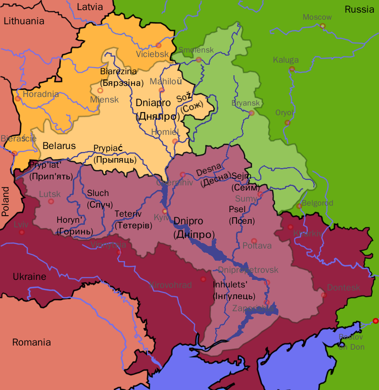
Tributaries of the Dnieper
The Dnieper has many tributaries. The main ones, in orographic sequence, are:
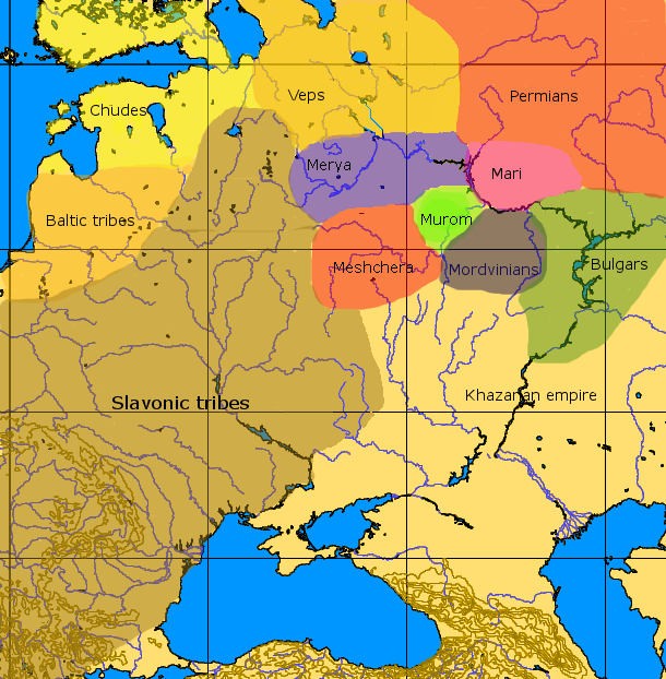
 Dnieper basin showing peoples in the ninth century
- Irpin (R)
- Desna (L)
- Stuhna (R)
- Trubizh (L)
- Ros (R)
- Tiasmyn (R)
- Supiy (L)
- Sula (L)
- Psyol (L)
- Vorskla (L)
- Samara (L)
- Konka (L)
- Bilozerka (L)
- Bazavluk (R)
- Inhulets (R)
Many small direct tributaries also exist, such as, in the Kiev area, the Syrets (right bank) in the north of the city, the historically significant Lybid (right bank) passing west of the centre, and the Borshagovka (right bank) to the south.
Fauna
The river is part of the Quagga mussel's native range.[citation needed] The mussel has been accidentally introduced around the world where it has become an invasive species.[citation needed]
Reservoirs and Hydroelectric power
The river is noted for its dams and hydroelectric stations.
The most noted was the Dnieper Hydroelectric Station or (DniproHES) near Zaporizhia, built in 1927-1932 with an output of 558 MW.[citation needed] It was destroyed during Second World War, and rebuilt in 1948 with an output of 750 MW.[citation needed]
The others are: Kremenchuk (1954–60), Kiev (1960–64), Dniprodzerzhynsk (1956–64), Kaniv (1963–75).[citation needed]
Those dams that used to generate hydroelectric power of ten percent of Ukraine's total electricity, form water reservoirs.
The reservoirs are named as Kiev (922 km2 or 356 sq mi), Kaniv (675 km2 or 261 sq mi), Kremenchuk (2,250 km2 or 870 sq mi), Dniprodzerzhynsk (567 km2 or 219 sq mi), Dnipro (420 km2 or 160 sq mi), and Kakhovka (2,155 km2 or 832 sq mi).[citation needed]
Cities and towns on the Dnieper
 Satellite image of the Dnieper and its tributaries.
Cities and towns located on the Dnieper are listed in order from the river's source (in Russia) to its mouth (in Ukraine):
- Cherkasy, Ukraine
- Kremenchuk, Ukraine
- Dniprodzerzhynsk, Ukraine
- Dnipropetrovsk, Ukraine
- Zaporizhia, Ukraine
- Marhanets, Ukraine
- Nikopol, Ukraine
- Enerhodar, Ukraine
- Kamianka-Dniprovska, Ukraine
- Nova Kakhovka, Ukraine
- Kherson, Ukraine
Arheimar, a capital of the Goths, was located on the Dnieper, according to the Hervarar saga.[citation needed]
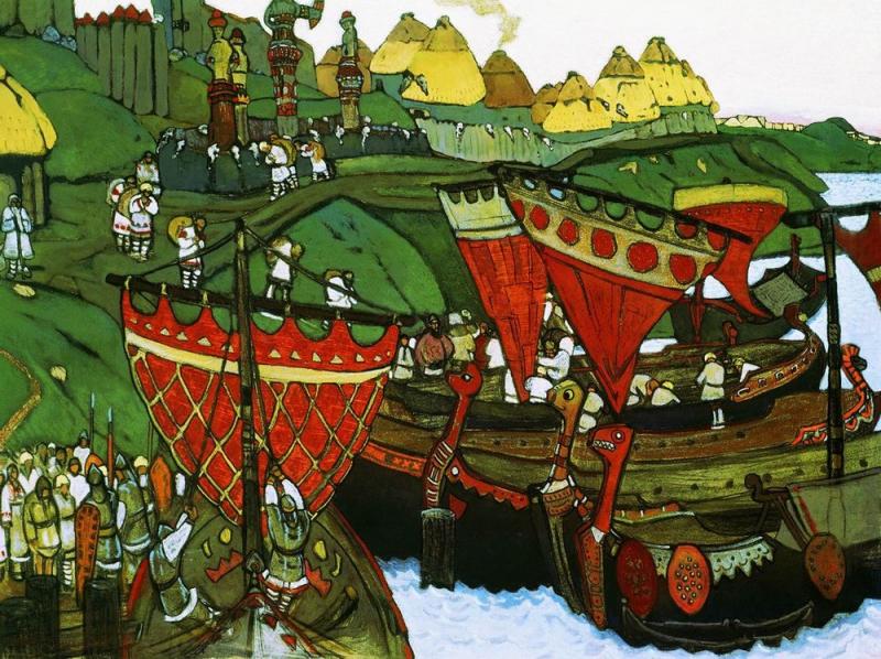
 Ships on the Dnieper by Nicholas Roerich
The Dnieper is important for the transport and economy of Ukraine[citation needed]: its reservoirs have large ship locks, allowing vessels of up to 270 by 18 metres (890 × 59 ft) to access as far as the port of Kiev and thus create an important transport corridor.[citation needed] The river is used by passenger vessels as well. Inland cruises on the rivers Danube and Dnieper have been a growing market in recent decades.
Upstream from Kiev, the Dnieper receives the water of the Pripyat River. This navigable river connects to the Dnieper-Bug canal, the link with the Bug River river. Historically, a connection with the Western European waterways was possible, but a weir without a ship lock near the town of Brest has interrupted this international waterway. Poor political relations between Western Europe and Belarus mean there is little likelihood of re-opening this waterway in the near future.[5]
Navigation is interrupted each year by freezing in winter, and severe winter storms.
Popular culture
- The river is one of the symbols of Ukrainian statehood.[citation needed]
- Some of the cities on its banks -- Dnipropetrovsk, Dniprorudne, Kamianka-Dniprovska -- are named after the river.
- The Zaporozhian Cossacks lived on the lower Dniepr and their name refers to their location "beyond the cataracts."[6]
- Folk metal band Turisas have a song called "The Dnieper Rapids" on their 2007 album The Varangian Way.[citation needed]
- Leon Bolier featured a track called "Dnipro" in his debut 2CD album Pictures. The track is said to be inspired by his visit to Kiev in May 2008.[citation needed]
- The river is described in the works of Taras Shevchenko as Dnipro (He roars and groans the Dnipro wide) and mentioned in the National anthem of Ukraine.[citation needed]
- The river is referred to as Dnipro, in the song Hey, Dnipro, Dnipro.[7]
See also

- Threat of the Dnieper reservoirs
- List of rivers of Russia
- List of rivers of Ukraine
- Trade route from the Varangians to the Greeks
References and footnotes
- ^ Mallory, J.P. and Victor H. Mair. The Tarim Mummies: Ancient China and the Mystery of the Earliest Peoples from the West. London: Thames and Hudson, 2000. p. 106
- ^ Jordanes, Getica 269.
- ^ http://crh.wikipedia.org/wiki/%C3%96z%C3%BC_%C3%B6zeni
- ^ a b Kubiyovych, Volodymyr; Ivan Teslia. "Dnieper River". Encyclopedia of Ukraine. http://www.encyclopediaofukraine.com/display.asp?AddButton=pages\D\N\DnieperRiver.htm. Retrieved January 19, 2007.
- ^ NoorderSoft Waterways Database
- ^ "...the Zaporohjans whose name meant 'those who live beyond the cataracts'...", Henryk Sienkiewicz, With Fire and Sword, chap. 7
- ^ Hey, Dnipro, Dnipro (youtube)
External links
- Dnieper River at the Encyclopedia of Ukraine
- 1911 Encyclopædia Britannica — Dnieper
- Brockhaus and Efron Encyclopedic Dictionary — Dnepr
- Site about Dnieper — objects over the river, photos, facts
- Charts river Dnieper — Charts river Dnieper
Dnieper River Tributaries1 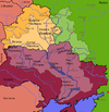
Reservoirs Hydroelectric
stations1 Italics indicate left tributariesCategories:- Dnieper River system
- International rivers of Europe
- Rivers of Smolensk Oblast
- Rivers of Homiel Voblast
- Rivers of Mahilyow Voblast
- Rivers of Vitsebsk Voblast
- Belarus–Ukraine border
- Zaporizhia Oblast
- Kiev
- Poltava Oblast
- Cherkasy Oblast
- Dnipropetrovsk Oblast
- Kherson Oblast
- Rivers of Ukraine


Wikimedia Foundation. 2010.