- Menai Strait
-
The Menai Strait (Welsh: Afon Menai, the "River Menai") is a narrow stretch of shallow tidal water about 25 km (16 mi)[1] long, which separates the island of Anglesey from the mainland of Wales.
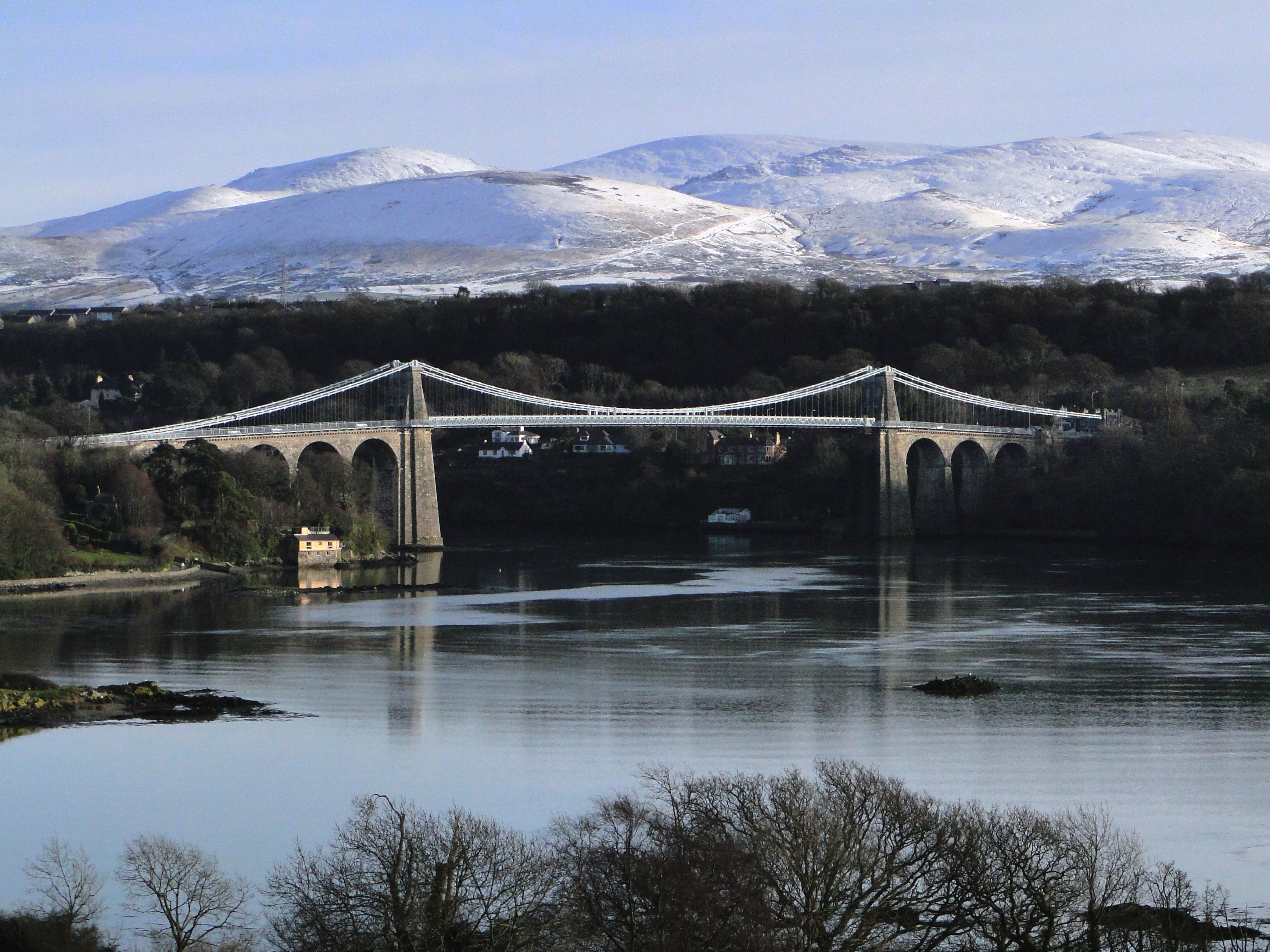
The strait is bridged in two places - the main A5 road is carried over the strait by Thomas Telford's elegant iron suspension bridge, the first of its kind, opened in January 1826, and adjacent to this is Robert Stephenson's 1850 Britannia Tubular Bridge. Originally this carried rail traffic in two wrought-iron rectangular box spans, but after a disastrous fire in 1970, which left only the limestone pillars remaining, it was rebuilt as a steel box girder bridge, and now carries both rail and road traffic. Between the two bridge crossings there is a small island in the middle of the strait, Ynys Gorad Goch, on which are built a house and outbuildings and around which are the significant remains of fish traps, no longer used.
 Menai Strait west of Britannia Bridge showing the memorial to Admiral Lord Nelson
The strait varies in width from 400 metres (1,300 ft) from Fort Belan to Aber Menai Point to 1,100 metres (3,600 ft) from Traeth Gwyllt to Caernarfon Castle. It then narrows to about 500 metres (1,600 ft) in the middle reaches (Y Felinheli and Menai Bridge) and then it broadens again. At Bangor Pier it is 900 metres (3,000 ft) wide. It then widens out, and the distance from Puffin Island to Penmaenmawr is about 7.5 kilometres (4.7 mi).[1] The differential tides at the two ends of the strait cause very strong currents to flow in both directions through the strait at different times, creating dangerous conditions. One of the most dangerous areas of the strait is known as the Swellies (or Swillies – Welsh Pwll Ceris) between the two bridges. Here rocks near the surface cause over-falls and local whirlpools, which can be of considerable danger in themselves and cause small boats to founder on the rocks. This was the site of the loss of the training ship HMS Conway in 1953. Entering the strait at the Caernarfon end is also hazardous because of the frequently shifting sand banks that make up Caernarfon bar. On the mainland side at this point is Fort Belan, an 18th-century defensive fort built in the times of the American War of Independence.
Contents
Origins
The present day channel is a result of erosion by successive ice-sheets during the series of Pleistocene glaciations. Ice moved from northeast to southwest across Anglesey and neighbouring Arfon scouring the bedrock, the grain of which also runs in this direction. The result was a series of linear bedrock hollows across the region, the deepest of which was flooded by the sea as world ocean levels rose at the end of the last ice age.
Tidal effects
 Glyn Garth flats on the banks of the Menai Strait opposite Upper Bangor
The tidal effects observed along the banks of the strait can also be confusing. A rising tide approaches from the south-west causes the water in the strait to flow north-eastwards as the level rises. The tide also flows around Anglesey until, after a few hours, it starts to flow into the strait in a south-westerly direction from Beaumaris. By the time this happens the tidal flow from the Caernarfon end is weakening and the tide continues to rise in height but the direction of tidal flow is reversed. A similar sequence is seen in reverse on a falling tide. This means that slack water between the bridges tends to occur approximately one hour before high tide or low tide.
Theoretically it is possible to ford the strait in the Swellies at low water, spring tides when the depth may fall to less than 0.5 metres (1.6 ft). However, at these times a strong current of around 9 kilometres per hour (5.6 mph) is running, making the passage extremely difficult. Elsewhere in the strait the minimum depth is never less than 2 metres (6.6 ft) until the great sand flats at Lavan sands are reached beyond Bangor.
Ecology
 A crab wearing a sponge suit seen underwater below the Menai Suspension Bridge
Marine
Because the strait has such unusual tidal conditions, coupled with very low wave heights because of its sheltered position, it presents a unique and diverse benthic ecology.
The depth of the channel reaches 15m in places, and the current can exceed 7 knots. It is very rich in sponges.
The existence of this unique ecology was a major factor in the establishment of the School of Ocean Sciences at Menai Bridge, part of the University of Wales, Bangor as well as its status as a special area of conservation with marine components.[2] The waters are also a proposed Marine Nature Reserve.[citation needed]
Land
The same unique ecology and geomorphology has let to a number of designations of SSSIs along the strait including Glannau Porthaethwy, the ivy - oak - ash woodland on the southern shore (Coedydd Afon Menai) and Lavan Sands (Traeth Lafan).
Much of the land on Anglesey at the eastern end of the strait is designated as an area of outstanding natural beauty.[citation needed]
Places on the Strait

- Beaumaris
- Bangor
- Caernarfon
- Menai Bridge
- Y Felinheli (formerly Port Dinorwic in English)
Just north of the rail bridge on Anglesey is the famously named Llanfairpwllgwyngyllgogerychwyrndrobwllllantysiliogogogoch.
Famous people
History
According to Heimskringla, the 11th Century Norse-Gael ruler Echmarcach mac Ragnaill plundered in Wales with his friend, the viking Guttorm Gunnhildsson. However they started quarreling over the plunder and fought a battle at Menai Strait. Guttorm won the battle by praying to Saint Olaf and Echmarcach was killed.
In the 12th Century, a later Viking raid and battle in the Menai Strait are recounted in the Orkneyinga Saga as playing an important role in the life of Magnus Erlendsson, Earl of Orkney - the future Saint Magnus. He had a reputation for piety and gentleness, and refusing to fight in the raid on Anglesey stayed on board his ship, singing psalms.
This incident is recounted at length in the 1973 novel Magnus by Orcadian author George Mackay Brown, and in the 1977 opera, The Martyrdom of St Magnus by Peter Maxwell Davies. The first of the opera's nine parts is called "The Battle of Menai Strait".
External links
- Menai Bridge Website Menai Bridge Town Partnership Website with details on the news, council, events and businesses of Menai Bridge
- Prosiect Menai A community celebrating the two bridges along the Menai Strait
- Wakeboarding on the Menai Strait
- Scuba diving the Menai Strait
- Live Webcam of the Menai Strait
References
- ^ a b http://www.glaucus.org.uk/Menai.htm
- ^ John Shaw MP (5 December 2007). "Seas and Oceans: environmental protection". Hansard. http://www.theyworkforyou.com/wrans/?id=2007-12-05f.170889.h&s=menai+strait#g170889.r0.
Coordinates: 53°10′50″N 4°14′00″W / 53.18056°N 4.2333333°W


Wikimedia Foundation. 2010.