- Metropolitan Borough of Battersea
-
Battersea
St MaryMotto: Non Mihi Non Tibi Sed Nobis
(Not for me, not for thee, but for us)
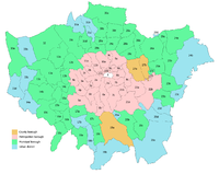
Battersea within the County of LondonGeography Status Civil parish (until 1965)
Metropolitan borough (1900—1965)1831 area 3,020 acres (12.2 km2)[1] 1851 area 2,343 acres (9.48 km2)[1] 1901 area 2,161 acres (8.75 km2)[1] HQ Municipal Buildings, Lavender Hill History Origin Ancient parish Abolished 1965 Succeeded by London Borough of Wandsworth Demography 1801 population 3,365[1] 1851 population
- 1851 density10,560[1]
4.5/acre1901 population
- 1901 density168,907[1]
78/acrePolitics Governance Vestry of the Parish of Battersea (1888—1900)
Battersea Borough Council (1900—1965)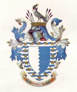
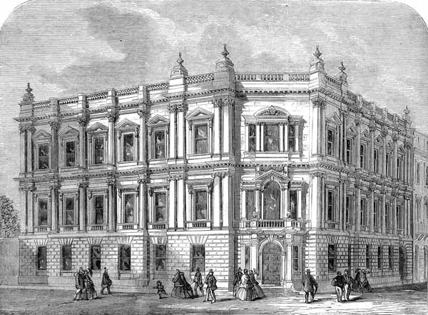
Coat of arms of the borough councilBattersea was a civil parish and metropolitan borough in the County of London, England. In 1965 the borough was abolished and its area combined with parts of the Metropolitan Borough of Wandsworth to form the London Borough of Wandsworth. The borough was administered from Battersea Town Hall on Lavender Hill and the building is now Battersea Arts Centre.
Contents
Ancient parish
As an ancient parish, Battersea was part of the Hundred of Brixton and County of Surrey. It included the exclave of Penge.
Parish in the Metropolis
In 1855, under the Metropolis Management Act 1855 the civil responsibilities of the parish were passed to the Metropolitan Board of Works. The two parts of the parish were assigned to different districts by the act establishing the MBW: Battersea was included in the area of the Wandsworth District Board of Works and the hamlet of Penge in that of Lewisham District Board of Works. Penge became a civil parish in its own right in 1866.
On 25 March 1888, a separate vestry was formed as a local authority for The parish of Saint Mary Battersea excluding Penge.[2] In 1889 the Local Government Act 1888 reconstituted the area of the Metropolitan Board of Works as the County of London, and Battersea was transferred from Surrey to the new county.[3]
The population of the parish in 1896 was 165,115 and it had adopted the Public Libraries Act 1850 immediately on obtaining local independence in 1888, with its own vestry. For electoral purposes the parish was divided into four wards and had 120 elected vestrymen.
Metropolitan borough
In 1900 the London Government Act 1899 divided the County of London into twenty-eight metropolitan boroughs, and the vestries and district boards were dissolved. The parish became the Metropolitan Borough of Battersea, with the borough council replacing the civil vestry.
The Metropolitan Borough included within its bounds Battersea, Battersea Park, Clapham Junction and parts of Wandsworth Common and Clapham Common.
In 1913 John Archer became mayor of the borough and the first black mayor in the country.[4]
Coat of arms
In 1901 the borough adopted an unofficial coat of arms, consisting of a shield vertically divided blue and white, the division line being indented. This design was taken from a flag dating from 1803. On top of the shield was a dove bearing an olive branch. The Latin motto was Non Mihi, Non Tibi, Sed Nobis, or "Neither for myself, nor for yourself, but for us".
In 1955 the borough received an official grant from the College of Arms, based on the old device. The colours in the shield were reversed, and a bordure or heraldic border added. The bordure consisted of silver and blue waves, representative of the River Thames, and bore sixteen gold stars for the sixteen wards of the borough. The new crest on top of the helm was the dove of the 1901 design, with the addition of sprigs of lavender, for the old lavender fields of the area, and Lavender Hill, the main road of Battersea. The old motto was retained.
Area and population
The area of the Borough was 2,163 acres (8.8 km2). The population recorded in the Census was:
Civil Parish 1801-1899
Year[5] 1801 1811 1821 1831 1841 1851 1861 1871 1881 1891 Population 3,365[6] 4,409[6] 4,764 5,311 6,617 10,560 19,600 54,016 107,262 150,558 Metropolitan Borough 1900-1961
Year[7] 1901 1911 1921 1931 1941 1951 1961 Population 168,907 167,743 167,739 159,552 [8] 117,140 105,870 Politics
The first election to the council was on 1 November 1900, with the Progressive Party taking control of the new borough. They retained power until 1909, when the Municipal Reform Party (allied to the Conservatives) gained a majority. The Progressives regained the council in 1912, holding power until 1919 when the Labour Party gained control. In 1931 the borough come under Municipal Reform control again. Labour regained power in 1934, retaining it for the rest of the borough's existence.
Elections of the whole council were held every three years. Elections were cancelled during the two world wars (1914-1918 and 1939-1945). The 1952 election was postponed for a year so that it did not clash with elections to the London County Council. The number of councillors returned at each election was as follows:.[9]
- Local elections
Year 1900 1903 1906 1909 1912 1919 1922 1925 1928 1931 1934 1937 1945 Progressives 37 38 29 2 29 Municipal Alliance 17 16 25 Municipal Reform 52 25 11 21 25 22 31 18 15 5 Labour 41 33 29 33 23 37 40 50 Discharged servicemen 2 No Municipal Reform candidates were nominated after 1946, and Conservative candidates were nominated at local elections for the first time.
Year 1949 1953 1956 1959 1962 Labour 34 37 46 34 40 Conservative 21 18 18 21 12 Liberal 3 Wards
From 1900 to 1949 the borough was divided into nine wards, returning either three, six or nine councillors:
- Bolingbroke (6 councillors)
- Broomwood (6)
- Church (6)
- Latchmere (6)
- Nine Elms (9)
- Park (6)
- St John (3)
- Shaftesbury (6)
- Winstanley (6)
In 1949 the wards were redrawn, with fourteen wards returning three to five councillors each:
- Bolingbroke (3)
- Broomwood (3)
- Church (4)
- Latchmere (4)
- Lavender (3)
- Newtown (3)
- Nightingale (5)
- Nine Elms (3)
- Park (4)
- Queenstown (4)
- St John (4)
- Shaftesbury (3)
- Stormont (3)
- Thornton (3)
- Vicarage (3)
- Winstanley (3)
The latest ward to be redrawn was Fairfield ward, with three councillors.
Parliamentary constituencies
For elections to parliament the borough was originally part of the parliamentary borough of Battersea and Clapham, which consisted of two divisions, Battersea and Clapham.
In 1918 the metropolitan borough was divided into two constituencies:
- Battersea North (Church, Latchmere, Nine Elms and Park wards) and
- Battersea South (Bolingbroke, Broomwood, St John, Shaftesbury and Winstanley wards)
The boundaries of the two constituencies were adjusted in 1949 to reflect the redrawn borough wards:
- Battersea North (Church, Latchmere, Newtown, Nine Elms, Park, Queenstown, Vicarage and Winstanley wards)
- Battersea South (Bolingbroke, Broomwood, Lavender, Nightingale, St John, Shaftesbury, Stormont and Thornton wards)
The constituencies continued unchanged until 1970.[10] when the Battersea constituency largely succeeded these two. The current MP is Conservative Jane Ellison.[11]
References
- Notes
- ^ a b c d e f Vision of Britain - Battersea population (area and density)
- ^ Metropolis Management (Battersea and Westminster) Act 1887 (50 & 51 Vict. C.17)
- ^ Local Government Act, 1888 (51 & 52 Vict. C. 41), s.40
- ^ John Archer biography (Black History) accessed 14 Jan 2008
- ^ Statistical Abstract for London, 1901 (Vol. IV); Census tables for Metropolitan Borough of Battersea
- ^ a b (probably including Penge)
- ^ Battersea MetB: Census Tables accessed 19 Jun 2007
- ^ The census was suspended for World War II
- ^ Election results as reported in The Times, 3 November, 1900; 4 November 1903; November 3, 1906; November 2, 1909; November 2, 1912; November 4, 1919; November 4, 1925; November 3, 1928; November 4, 1931; November 3, 1934; November 3, 1937; November 2, 1945; May 7, 1949; May 7, 1953; May 11, 1956; May 8, 1959; May 12, 1962
- ^ F.A. Youngs, Guide to the Local Administrative Units of England, Volume 1, 1979
- ^ [1] MPs in the UK Parliament
- Bibliography
- "The London Manual 1899-1900" edited by Robert Donald (Edward Lloyd Ltd., 1899)
Local government districts abolished or transferred by the London Government Act 1963 London · CC Battersea · Bermondsey · Bethnal Green · Camberwell · Chelsea · Deptford · Finsbury · Fulham · Greenwich · Hackney · Hammersmith · Hampstead · Holborn · Islington · Kensington · Lambeth · Lewisham · Paddington · Poplar · Shoreditch · Southwark · St. Marylebone · St. Pancras · Stepney · Stoke Newington · Wandsworth · Westminster · Woolwich
Constituent parts of Greater LondonEssex Barking · Chigwell (part) · Chingford · Dagenham · East Ham · Hornchurch · Ilford · Leyton · Romford · Walthamstow · Wanstead and Woodford · West Ham
Hertfordshire Middlesex · CC Acton · Brentford and Chiswick · Ealing · Edmonton · Enfield · Feltham · Finchley · Friern Barnet · Harrow · Hayes and Harlington · Hendon · Heston and Isleworth · Hornsey · Ruislip-Northwood · Southall · Southgate · Tottenham · Twickenham · Uxbridge · Wembley · Willesden · Wood Green · Yiewsley and West Drayton
Kent Surrey Transfers Metropolitan Board of Works Districts Fulham · Greenwich · Hackney · Holborn · Lee/Plumstead · Lewisham · Limehouse · Poplar · St Giles · St Olave · St Saviour's · Strand · Wandsworth · Westminster · Whitechapel
Headquarters at Spring GardensIncorporated vestries Battersea · Bermondsey · Bethnal Green · Camberwell · Chelsea · Clerkenwell · Fulham · Hackney · Hammersmith · Hampstead · Islington · Kensington · Lambeth · Mile End Old Town · Newington · Paddington · Plumstead · Rotherhithe · St George Hanover Square · St George in the East · St Luke Middlesex · St Martin in the Fields · St Marylebone · St Pancras · Stoke Newington · Shoreditch · Southwark St George the Martyr · Westminster St Margaret and St John · Westminster St James · WoolwichUndertakings Major works Legislation Royal Commission on the City of London · Metropolis Management Act 1855 · Metropolis Toll Bridges Act 1877 · Metropolitan Board of Works (Money) Act 1885 · Metropolis Management Amendment Act 1885 · Local Government Act 1888 · London Government Act 1899People Categories:- Metropolitan boroughs of the County of London
- History of Wandsworth
- Parishes governed by vestries (Metropolis)
- Parishes united into districts (Metropolis)
- Former civil parishes in England
- 1900 establishments in the United Kingdom
- 1965 disestablishments


Wikimedia Foundation. 2010.