- Duxford
-
This article is about the village in Cambridgeshire, England. For the village in Oxfordshire, see Duxford, Oxfordshire.For the branch of the Imperial War Museum located in the village, see Imperial War Museum Duxford.
Coordinates: 52°05′32″N 0°09′34″E / 52.09226°N 0.15944°E
Duxford 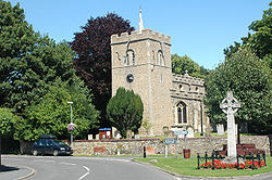
 Duxford
Duxford shown within CambridgeshirePopulation 1,836 [1] OS grid reference TL481461 District South Cambridgeshire Shire county Cambridgeshire Region East Country England Sovereign state United Kingdom Post town Cambridge Postcode district CB22 Dialling code 01223 Police Cambridgeshire Fire Cambridgeshire Ambulance East of England EU Parliament East of England UK Parliament South Cambridgeshire List of places: UK • England • Cambridgeshire Duxford is a village in Cambridgeshire, England, some ten miles south of Cambridge.
Contents
History
The village formed on the banks of the River Cam, a little below its emergence from the hills of north Essex. One of the more populous settlements in its hundred it was split into two ecclesiastical parishes in medieval times until they were united in 1874. [2]
Originally known as Duxworth and listed as Dukeswrthe in the 10th century, and Dochesuuorde in the Domesday Book the village's name comes from "Worth (enclosure) of a man called Duc".[3]
Churches
 St John's church
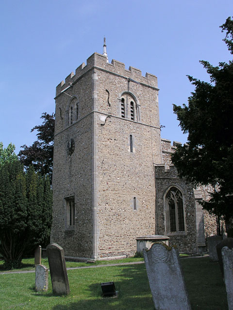
From medieval times the village was unusual in possessing two parish churches, each with a separate incumbent.
Main article: St John's Church, DuxfordThe church of St John the Baptist, as it's been known since at least 1260, consists of a chancel and north chapel, a central tower, and a nave with north aisle and south porch. The chancel, nave, and lower part of the tower were all built in the 12th century, with the tower raised in the 13th century. By the 1860s the building was in disrepair and after the parishes were merged in 1874, the church fell into disuse, and became increasingly delapidated over the course of the 20th century, though received a new roof and stone floor in the 1960s. Since 1979 it has been run by the Churches Conservation Trust.[2]
 St Peter's church
The southerly church has been dedicated to St Peter since at least 1275, and serves as Duxford's present parish church. Built with a chancel, an aisled and clerestoried nave, and a west tower, it too was originally built in the 12th century, and the tower and part of the chancel remain from this period. The nave was rebuilt in the 14th or 15th century. In 1728 the tower had the existing tall spire removed and replaced with the present shorter one. By the time the parishes were merged, the building was also in a poor state, and had to be extensively repaired in the 1880s.[2]
Main article: Duxford ChapelTo the north of the village close to the Royston to Newmarket road lies Duxford Chapel, a 14th century chantry chapel that was probably part of the Hospital of St John.[4]
A Congregational chapel was built in the late 18th century and licensed in 1794, and at its peak in 1850 had a weekly congregation of 350. The chapel was still active in 1970 but is now closed.[2]
Airfield
Duxford gives its name to RAF Duxford, a former Royal Air Force airfield that was used as a sector station during the Battle of Britain. Duxford Aerodrome was the home of Douglas Bader's Big Wing during that battle. Duxford airfield later became a fighter airfield for the United States Army Air Forces operating P47 Thunderbolt aircraft. In 1972 the Ministry of Defence began to house historically important aircraft in the hangars, which became the Imperial War Museum Duxford.
The airfield was used in the motion picture The Battle of Britain. During that production one of the hangars was blown up to simulate a Luftwaffe bombing raid.
Village life
The village has two remaining pubs – the John Barleycorn and The Wheatsheaf. Former pubs include The Three Horseshoes, first recorded in 1786, and The King's Head and the Plough which both opened in the mid-19th century.[2]
References
- ^ 2001 Census
- ^ a b c d e A History of the County of Cambridge and the Isle of Ely. 6. Victoria County History. 1978. pp. 201–220. http://www.british-history.ac.uk/report.aspx?compid=66724.
- ^ A. D. Mills (2003). "A Dictionary of British Place-Names". http://www.encyclopedia.com/doc/1O40-Duxford.html.
- ^ Duxford Chapel
See also
External links
Categories:- Villages in Cambridgeshire
- Civil parishes in Cambridgeshire


Wikimedia Foundation. 2010.