- Drumoak
-
Coordinates: 57°05′10″N 2°20′18″W / 57.08622°N 2.338277°W
Drumoak 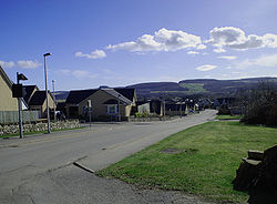
Drumoak Village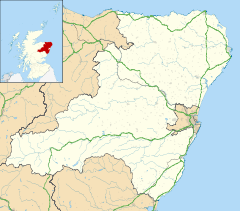
 Drumoak
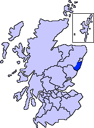
Drumoak shown within AberdeenshirePopulation 810 (2006) [1] OS grid reference NO7999 Council area Aberdeenshire Lieutenancy area Kincardineshire Country Scotland Sovereign state United Kingdom Postcode district AB31 5xx Dialling code 01330 811 xxx Police Grampian Fire Grampian Ambulance Scottish EU Parliament Scotland UK Parliament West Aberdeenshire and Kincardine Scottish Parliament West Aberdeenshire and Kincardine List of places: UK • Scotland •  Drumoak and district bowling green
Drumoak (Scottish Gaelic: Druim M'Aodhaig, the ridge of St Aodhag) is a village situated between Peterculter and Banchory in North Deeside, Aberdeenshire, Scotland.[1] Drumoak is proximate to the River Dee, with Park Bridge, named for the local Park Estate, being a local crossing; Park Estate,[2] was formerly owned by the railway engineer Sir Robert Williams;[3] Sir Robert is interred at Drumoak.
There is a church, small shop, bowling green and the Irvine Arms restaurant (after the family that owned 13 century Drum Castle). Drum Castle is run by the National Trust and is open to visitors. Relics and portraits of the Irvine family are kept here, and it was conferred by Robert the Bruce onto William de Irvine. There are a number of housing developments progressing; a small primary school with about 100 pupils serves Drumoak. The Dee River gravels also attract gravel extraction on both sides of the river.
Drumoak Manse in 1638 was the birthplace of James Gregory (astronomer and mathematician),[4] discoverer of diffraction gratings a year after Newton's prism experiments, and inventor of the Gregorian telescope design in 1663. The design is still used today in telescopes such as the Arecibo Radio Telescope upgraded to a Gregorian design in 1997 giving Arecibo a flexibility it had not previously possessed.
Between Drumoak and Peterculter is the site of a Roman encampment Normandykes
History
A history of Drumoak was commissioned by the Kirk Session of Drumoak Parish Church in 2000 in order to commemorate the second millennium. It was entitled The Parish of Drumoak and was written by Robin Jackson. Copies of the book can be obtained from the Aberdeen and North East of Scotland Family History Society, 164 King Street, Aberdeen, AB24 5BD. http://www.anesfhs.org.uk
 Drumoak Church
See also
References
- ^ AA Touring Guide to Scotland (1978)
- ^ "http://www.georgegoldsmith.com/estates/detail.html?id=49"
- ^ Robert Clarke Hutchinson, George MartelliRobert's People: The Life of Sir Robert Williams, Chatto and Windus, 1971
- ^ http://www-history.mcs.st-andrews.ac.uk/Biographies/Gregory.html
Settlements and places of interest in Kincardine and Mearns, Aberdeenshire Primary settlements Auchenblae · Drumoak · Fettercairn · Gourdon · Inverbervie · Johnshaven · Laurencekirk · Newtonhill · Portlethen · St Cyrus · Stonehaven
Other settlements Arbuthnott · Banchory-Devenick · Bridge of Muchalls · Cammachmore · Catterline · Cookney · Downies · Drumlithie · Findon · Fordoun · Glenbervie · Kinneff · Kirkton of Durris · Maryculter · Marykirk · Muchalls · Netherley · Portlethen Village
Places of interest Causey Mounth · Crawton · Drum Castle · Dunnottar Castle · Fetteresso Castle · Fowlsheugh Nature Reserve (Craiglethy) · Monboddo House · Muchalls Castle · Normandykes · Portlethen Moss · Raedykes · Stonehaven Open Air Pool · Stonehaven Tolbooth
Areas and primary settlements in Aberdeenshire
(see also: Aberdeen City)in Banff and Buchan Aberchirder · Banff · Fraserburgh · Gardenstown · Inverallochy and Cairnbulg · Macduff · Portsoy · Rosehearty · Sandhaven · Whitehills
in Buchan Boddam · Crimond · Cruden Bay · Fetterangus · Hatton · Longside · Maud · Mintlaw · New Deer · New Pitsligo · Peterhead · St Combs · St Fergus · Strichen · Stuartfield
in Formartine Balmedie · Cuminestown · Ellon · Fyvie · Newburgh · Oldmeldrum · Pitmedden · Potterton · Rothienorman · Tarves · Turriff
in Garioch in Kincardine and Mearns Drumoak · Fettercairn · Gourdon · Inverbervie · Johnshaven · Laurencekirk · Newtonhill · Portlethen · St Cyrus · Stonehaven
in Marr Categories:- Aberdeenshire geography stubs
- Villages in Aberdeenshire


Wikimedia Foundation. 2010.