- Brisbane central business district
-
Brisbane CBD
Brisbane, Queensland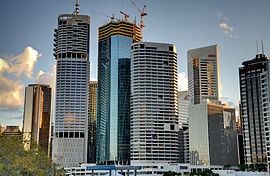
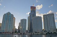
Brisbane CBD from Kangaroo PointPopulation: 12,800 (2009)[1] Postcode: 4000 Area: 0.7 km² (0.3 sq mi) LGA: Brisbane City Council, Central Ward County: Stanley Parish: North Brisbane State District: Brisbane Central Federal Division: Brisbane Suburbs around Brisbane CBD: Red Hill and Paddington Spring Hill Fortitude Valley Petrie Terrace Brisbane CBD New Farm South Brisbane Woolloongabba Kangaroo Point  Map of the CBD
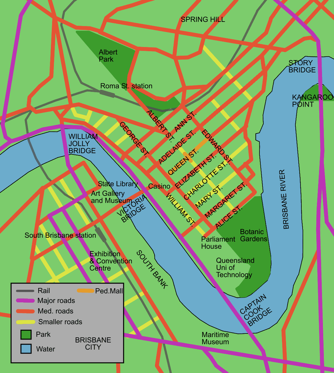
The Brisbane central business district (CBD), sometimes referred to as the city, is a suburb of Brisbane, Queensland, Australia and is located on a point on the northern bank of the Brisbane River. The triangular shaped area is bounded by the Brisbane River to the east, south and west. The point, known at its tip as Gardens Point, slopes upward to the north-west where the city is bounded by parkland and the inner city suburb of Spring Hill to the north. The CBD is bounded to the north-east by the suburb of Fortitude Valley. To the west the CBD is bounded by Petrie Terrace, which in 2010 was reinstated as a suburb (after being made a locality of Brisbane City in the 1970s).
Contents
Geography
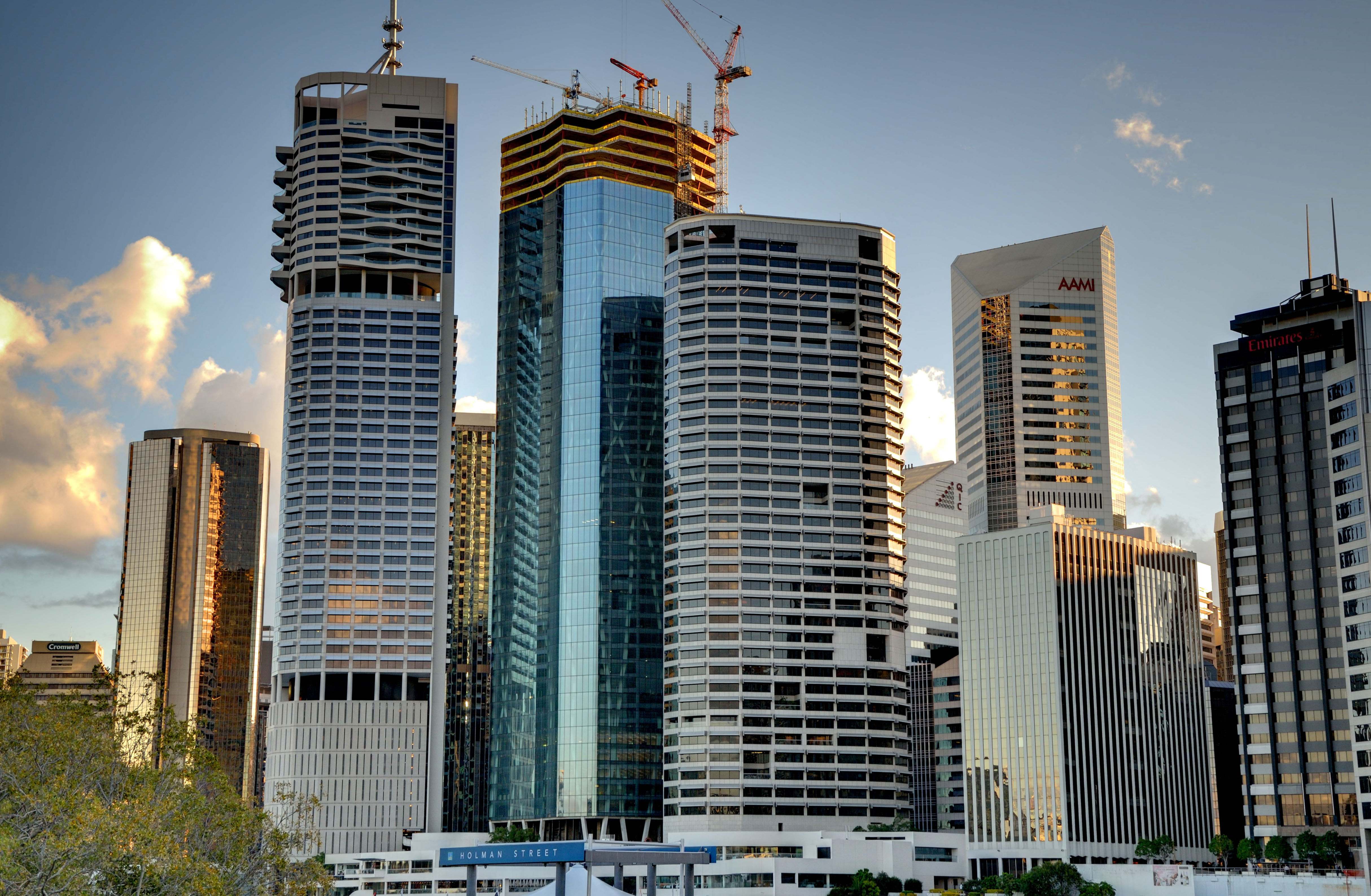
 Soleil building under construction
 Aerial view of the central business district (top) from the east.
The Brisbane CBD is an area of densely concentrated skyscrapers and other buildings, interspersed by several parks such as Roma Street Parklands, City Botanic Gardens and Wickham Park. The City is laid out according to a grid pattern surveyed during the city's early colonial days, a feature typical of most Australian street patterns. As a general rule, the streets aligned northwest-south east are named after male members of the House of Hanover, while the northeast-south west aligned streets are named after female members.[citation needed] Queen Street was the central roadway, that was turned into a pedestrian mall. It forms the pivotal axis for the grid of roads within the district.
The Brisbane central business district was built on a spur of the Taylor Range with the highest spot in the suburb being Wickham Terrace.[2] North Quay is an area in the CBD that was a landing point during the first European exploration of the Brisbane River.
Petries Bight
Petries Bight, also known as Petrie Bight, is a small pocket of land centered on the area under the Story Bridge's northern point, around the Brisbane River to Admiralty Towers II. The location was originally known as Petrie Gardens and was an early settlement farm, one of two that provided food for the colony.[3] The site was named after Andrew Petrie and has been the base for water police and in earlier times wharves.[4] The location of Customs House and the preference for wharves was due to site being directly downstream from the central business district.[4]
Buildings and precincts
See also: List of tallest buildings in BrisbaneUp until 1964, a Brisbane City Council regulation limited building heights to 132 ft (40 m).[5] Some of the first skyscrapers built in the CBD include the SGIO building (now Suncorp Plaza) in 1970 and AMP Place in 1977.
In the last few decades the number of apartment buildings that have been constructed has increased substantially. Brisbane is home to several of Australia's tallest buildings. Brisbane's tallest buildings are Soleil at 243 metres, Aurora Tower at 207 metres, Riparian Plaza at 200 metres, One One One Eagle Street at 195 metres, and Infinity, at 249 metres, which is currently under construction.[6]
The Brisbane CBD is one of the major business hubs in Australia.[7] The City contains many tall office buildings occupied by organisations, businesses and all three levels of government that have emerged into a number of precincts. The areas around the Queen Street Mall and Adelaide Street is primarily a retail precinct. A legal precinct exists around the various court buildings located around the intersections of George Street and Adelaide and Ann Streets.
The government precinct is an area centered around the Executive Building that includes a many Queensland Government offices. 111 George Street, Mineral House, Education House and the Neville Bonner building in William Street are also located here.
The Brisbane CBD has only one third the number of premium hotel rooms that either Sydney or Melbourne's central business districts have.[8]
Schools
The city is serviced by a number of schools in the surrounding suburbs including the Petrie Terrace State School in Paddington and The Albert Park Flexi School in Petrie Terrace.
Rental prices
Like most other Australian capital cities Brisbane has experienced dramatic rises in rental prices for residential and office space before the global financial crisis. At the beginning of 2008, the Brisbane central business district contained 1.7 million square metres of office space.[9] High demand in the office market had pushed vacancy rates in the Brisbane CBD to 0.7% by January 2008, the lowest in Australia.[9] Premium grade office space was even less vacant with an occupancy rate of 99.9%. By the end of 2009 the situation had reversed. Brisbane now has the highest CBD vacancy rate for office space in the country.[10]
Attractions

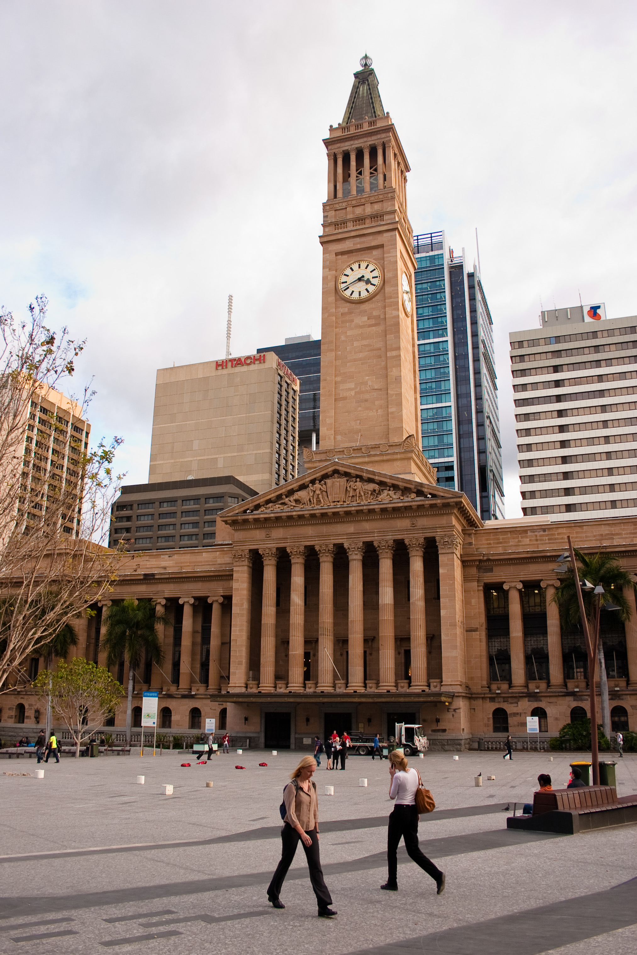
In the CBD there many attractions; Queensland's Parliament House, The Pancake Manor, The Masonic Memorial Centre, the Queensland University of Technology Gardens Point Campus and the Brisbane City Hall. The Queens Gardens, Post Office Square, King George Square and Brisbane City Botanic Gardens are open public spaces located here.
Transport
See also: Transport in BrisbaneBy road, four road bridges connect the CBD with the southern bank of the Brisbane River: the Captain Cook Bridge, the Victoria Bridge, the William Jolly Bridge and the Go Between Bridge. The Story Bridge connects Fortitude Valley with Kangaroo Point and provides access to the city from the southern bank. The Captain Cook Bridge connects the Pacific Motorway, south of the river, with the Riverside Expressway which runs along the south western edge of the city. Heading under and bypassing the CBD is the Clem Jones Tunnel.
By bicycle and foot, the Goodwill Bridge allows cross river access to South Bank.
The Brisbane central business district is the central hub for all public transport services in Brisbane. Bus services are centred on the Queen Street Bus Station and King George Square bus station. Suburban train services pass through Central railway station, and Roma Street railway station. Roma Street also serves as the terminus for long distance and country services. The central business district is served by various city ferries. Brisbane's CityCat high speed ferry service, popular with tourists and commuters, operates services along the Brisbane River between the University of Queensland and Brett's Wharf, stopping at several CBD wharves.
The Brisbane Riverwalk, a pedestrian and cyclist pathway adjoins the central business district along the river bank.[11]
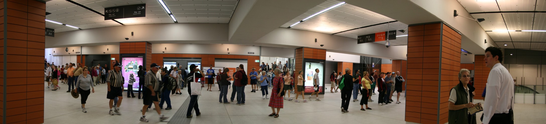
 King George Square Busway Station, an underground bus station
In popular culture
The Brisbane CBD has featured in a number of films, including:
- Inspector Gadget 2, the sequel to Inspector Gadget, featured many scenes showing the Brisbane CBD, South Bank and Kangaroo Point.
- The Marine, a film featuring John Cena, featured the Golden Triangle district of the CBD, during a scene in which an explosion occurred.
- Fool's Gold, a 2008 film featured the CBD primarily the Botanic Gardens throughout the beginning of the film.
- One of Jackie Chan's films, Jackie Chan's First Strike, featured the city in many scenes to the end of the film from Fortitude Valley, east of the CBD.
- The Brisbane CBD was used in Powerfinger's 2009 music video "All of the Dreamers".
- The 2009 vampire film Daybreakers was filmed in Brisbane.
See also
References
- ^ Tony Moore (5 November 2010). "CBD bulges as more move in". Brisbane Times (Fairfax Media). http://www.brisbanetimes.com.au/business/property/cbd-bulges-as-more-move-in-20101104-17fon.html. Retrieved 30 November 2010.
- ^ Gregory, Helen (2007). Brisbane Then and Now. Wingfield, South Australia: Salamander Books. p. 60. ISBN 9781741730111.
- ^ "Brisbane - Then and Now - The Centenary of Federation". Australian Broadcasting Corporation. 2001-04-24. http://www.abc.net.au/queensland/federation/stories/s281845.htm. Retrieved 2009-08-21.
- ^ a b Gregory, Helen (2007). Brisbane Then and Now. Wingfield, South Australia: Salamander Books. p. 20. ISBN 9781741730111.
- ^ McBride, Frank; et al (2009). Brisbane 150 Stories. Brisbane City Council Publication. pp. 284–285. ISBN 978-1-875091-60-6.
- ^ http://buildingdb.ctbuh.org/?do=create>
- ^ "Brisbane business visitor numbers skyrocket". Brisbane Marketing Convention Bureau. e-Travel Blackboard. 3 January 2008. http://www.etravelblackboard.com/index.asp?id=73027&nav=13. Retrieved 2008-01-13.
- ^ Tony Moore (30 November 2010). "New 32-storey hotel planned for CBD". Brisbane Times (Fairfax Media). http://www.brisbanetimes.com.au/business/property/new-32storey-hotel-planned-for-cbd-20101129-18e1i.html. Retrieved 30 November 2010.
- ^ a b "Business boom leaves Brisbane without office space". news.com.au (News Limited). http://www.news.com.au/story/0,23599,23170498-421,00.html. Retrieved 2008-11-25.[dead link]
- ^ Bridget Carter (1 October 2009). "Brisbane office glut to persist for five years". The Australian (News Limited). http://www.theaustralian.com.au/business/property/brisbane-office-glut-to-persist-for-five-years/story-e6frg9gx-1225781340498. Retrieved 2 June 2010.
- ^ "About RiverWalk". Brisbane City Council. Archived from the original on September 16, 2006. http://web.archive.org/web/20060916142104/http://www.brisbane.qld.gov.au/BCC:STANDARD::pc=PC_1217. Retrieved 2008-01-05.
Further reading
- Petrie-Terrace Brisbane 1858-1988 - Its ups and downs, R. Fisher, Boolarong, 1988 ISBN 0-86439-050-5
External links
- Brisbane central business district is at coordinates 27°27′45″S 153°01′28″E / 27.46251°S 153.02432°ECoordinates: 27°27′45″S 153°01′28″E / 27.46251°S 153.02432°E
- BRISbites: Suburban Sites (History)
Categories:- Suburbs of Brisbane
- Central business districts in Australia


Wikimedia Foundation. 2010.