- Chalfont St Peter
-
Coordinates: 51°36′25″N 0°33′18″W / 51.607°N 0.555°W
Chalfont St Peter 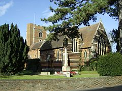
St. Peter's parish church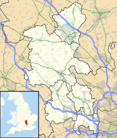
 Chalfont St Peter
Chalfont St Peter shown within BuckinghamshirePopulation 12,937 [1] OS grid reference TQ0090 Parish Chalfont St. Peter District Chiltern Shire county Buckinghamshire Region South East Country England Sovereign state United Kingdom Post town Gerrards Cross Postcode district SL9 Dialling code 01753/01494 Police Thames Valley Fire Buckinghamshire Ambulance South Central EU Parliament South East England UK Parliament Chesham and Amersham Website Chalfont St Peter List of places: UK • England • Buckinghamshire Chalfont St Peter is a village and civil parish in Chiltern district in south-east Buckinghamshire, England. It is in a group of villages called The Chalfonts which also includes Chalfont St Giles and Little Chalfont. The villages lie between High Wycombe and Rickmansworth. Chalfont St Peter is one of the largest villages in the UK with nearly 13,000 residents. The urban population for Chalfont St Peter and Gerrards Cross is 19,622,[2] the two villages being considered a single area by the Office for National Statistics.
Gerrards Cross was once a hamlet in the parish of Chalfont St Peter, but it is now a village and civil parish in its own right.
Gerrards Cross and Chalfont St Peter have a reputation for being upmarket and exclusive, with house prices being considerably higher than average.
Many celebrities[who?] reside there due to the close proximity to central London (15 miles), Pinewood and Elstree film studios, private schools, the countryside, Heathrow Airport and the motorway network (M25, M40, M1 and M4).
Contents
History
Early history
At the time of the Anglo-Saxon Chronicle in 949 there was no distinction made between the three separate villages: the whole area was known as Ceadeles funtan, which is Anglo-Saxon meaning Caedele's Spring. The villages were however separated by 1237 when in manorial rolls Chalfont St Peter was referred to as Chalfund Sancti Petri. The suffix St Peter is taken from the dedication of the church in the village. Chalfont St Peter was described in 1806 in Magna Britannia as follows:
- "Chalfont St Peter, in the hundred and deanery of Burnham, lies about five miles from Amersham, on the road to London, and nearly six miles from Uxbridge in Middlesex. The manor, which belonged to Missenden Abbey, was granted in 1536 to Robert Drury esq. whose descendants sold it in 1626 to the Bulstrodes: in 1646 it was conveyed to Thomas Gower esq. of whom, in 1650, it was purchased by Mr. Richard Whitchurch, ancestor of Mrs. Anne Whitchurch, the present proprietor.
- "An ancient manor in this parish takes its name from the family of Brudenell, (collateral ancestors of the Earl of Cardigan), who formerly possessed it; from them it descended by female heirs to the Drurys and Osbornes. It afterwards came into the Duke of Portland's family, of whom it was purchased by Charles Churchill esq. the late proprietor; it is now the property of Thomas Hibbert esq. Mr. Hibbert's seat, which is called Chalfont-house, was a distinct property; and before it came into Mr. Churchill's hands, was in the families of Wilkins and Selman.
- "Newlands, in this parish, the seat of Sir Henry Thomas Gott, was purchased by its present possessor about the year 1770, of Mr. Croke of Beaconsfield: it had been formerly in the family of Saunders, and was sold by Sir John Saunders to Mr. Hopkins, of whom it was purchased by Mr. Croke.
 An old photo of Chalfont St Peter Church of England Church
- "In the church are memorials for the family of Whitchurch. The advowson and impropriation which belonged formerly to Missenden abbey, and afterwards to the Drurys, was given by Sir Thomas Allen to the president and scholars of St. John's college in Oxford, who present the vicar and grant him a lease of the great tithes.
- "The Earl of Portland built a school at Gerrard's Cross, in this parish, adjoining the road from London to High Wycombe. It has no endowment, but has always been supported by the Portland family: the duke appoints the master, and allows him a salary for teaching a number of boys of this and some of the neighbouring parishes.
- "William Courtnay, who died in 1770, gave a loaf of bread weekly to each of eleven unmarried poor women of this parish, and one to the clerk."
Modern history
Today, Chalfont St Peter is one of the largest villages in the United Kingdom partly due to the proximity to Gerrards Cross railway station which lies between London Marylebone and Birmingham Snow Hill on the Chiltern Main Line. Modern buildings and urbanisation now dominate the village centre and very little historic architecture remains. The first major development of the village were rows of Georgian shops (some of which still remain). Much larger developments came in the late 1920s and these shops that run up the main street towards Gold Hill common now comprise most of the village centre. Modernisation and urbanisation continued up until the 1960s when most of the Georgian shops were demolished in favour of a concrete development of flats, offices and shops fronts surrounding a central car park.
 Gold Hill Common
Popularity
The population boom
Since the building of Gerrards Cross railway station in the late 19th century, the population of Chalfont St Peter has risen dramatically. From 1801 to 1901, the populations of the village only saw a 700 person rise – giving a population of 1700. But from 1901 to the present, it has become one of the largest villages in the United Kingdom, with nearly 13,000 inhabitants.
Tourist attractions
Chalfont St Peter is often described as the Gateway to the Chiltern Hills. It is not a major tourist centre but has many places to stay the most notable being The Greyhound, (former local court house where hangings took place) which is situated at the foot of the village on the banks of the River Misbourne. While there are no tourist attractions within the village, it is well-placed for easy access to London (which only takes 30 minutes) and easy access to all of the tourist attractions within the Chiltern Hills. Nearby there are several manor houses of note, as well as many museums, cottages and parks. Milton's Cottage in Chalfont St Giles, Colne Valley Regional Park, Bekonscot Model Village, Chenies Manor House, Chiltern Open Air Museum, Odds Farm Park, Cliveden, Dorney Court, Harrow Museum & Heritage Centre, Royal Windsor Racecourse and Hughenden Manor are the nearest attractions to the village itself.
Education
 Chalfonts Community College
- Robertswood Combined and Nursery School
- Chalfont St Peter Infant School
- Chalfont St. Peter Church of England School
- St. Joseph's Combined Catholic School
- Chalfonts Community College
- Gayhurst School – Private Boys
- Holy Cross Convent – Private Girls (Closed summer 2006)
- Maltman's Green School — Private Girls
The headquarters of Bradt Travel Guides founded by Hilary Bradt in 1974 is also located in Chalfont.
Churches
Hamlets
Hamlets in Chaflont St Peter include:
- Austenwood
- Chalfont Common
- Gravel Hill
- Layters Green
Transport
Many bus routes run through the main town and the more suburban areas. These bus routes include connections with Slough, Amersham, Berkhamsted and Uxbridge. It is also close to Gerrards Cross railway station which has links to Marylebone and High Wycombe and Birmingham.
Other institutions
Notable residents
- Comedy Dave – a member of the Chris Moyles Show team on BBC Radio 1
- Sarah Harding - singer with the pop group Girls Aloud
- John Laurie (1897–1980) - Scottish actor, best known for his role as Private James Frazer, in the BBC sitcom Dad's Army
- Patrick O'Brian (1914–2000) - author of the Aubrey-Maturin series of novels was born here
- Dame Margaret Rutherford (1892-1972) - English actress, best known for her role as Miss Marple in several films loosely based on Agatha Christie's novels
- Len Worley, amateur footballer
References
Further reading
- "A History of Chalfont St Peter and Gerrards Cross", C G Edmonds, 1964 and "The History of Bulstrode", A. M. Baker, 2003 published as one book by Colin Smythe Ltd, 2003
External links
Chiltern District Towns
(Component Areas
and Hamlets)Amersham (Woodrow) • Chesham (Botley, Chesham Vale, Chessmount, Codmore, Great Hivings, Hilltop, Lye Green, Newtown, Orchard Leigh, Pednormead End, Pond Park, Waterside)
Other Civil Parishes
(Component Villages
and Hamlets)Ashley Green (Ashley Green, Whelpley Hill) • Chenies • Chalfont St Giles (Bottrells Close, Chalfont Grove, Chalfont St Giles, Jordans, Stratton Chase) • Chalfont St Peter (Austenwood, Chalfont Common, Gravel Hill, Layters Green) • Chartridge (Asheridge, Bellingdon, Chartridge, Hundridge, Pednor, Pednor Bottom) • Chesham Bois • Cholesbury-cum-St Leonards (Buckland Common, Cholesbury, Hawridge, St Leonards) • Coleshill • Great Missenden (Ballinger, Ballinger Bottom, Ballinger Common, Bryant's Bottom, Frith-hill, Great Missenden, Heath End, Hotley Bottom, Hyde End, Little Wood Corner, Mobwell, Prestwood, South Heath) • Latimer (Latimer, Ley Hill, Tyler's Hill) • Little Chalfont • Little Missenden (Beamond End, Holmer Green, Hyde Heath, Little Kingshill, Little Missenden, Mantles Green, Mop End, Spurlands End) • Penn (Beacon Hill, Forty Green, Knotty Green, Penn, Penn Bottom, Penn Street, Winchmore Hill) • Seer Green • The Lee (Lee Clump, Lee Common, Lee Gate, Hunt's Green, Swan Bottom, The Lee)Former Districts
and BoroughsFormer
ConstituenciesCategories:- Villages in Buckinghamshire
- Civil parishes in Buckinghamshire


Wikimedia Foundation. 2010.