- Cribyn
-
For the mountain in the Brecon Beacons, see Cribyn (hill).
Coordinates: 52°08′20″N 4°09′43″W / 52.139°N 4.162°W
Cribyn 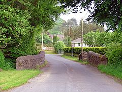
Small bridge over Nant Fudr-fach, Cribyn, Ceredigion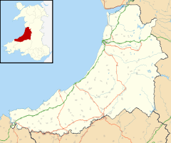
 Cribyn
Cribyn shown within CeredigionOS grid reference SN521511 - Cardiff 90 mi (140 km) SE Principal area Ceredigion Ceremonial county Dyfed Country Wales Sovereign state United Kingdom Post town Lampeter Postcode district SA48 Dialling code 01570 Police Dyfed-Powys Fire Mid and West Wales Ambulance Welsh EU Parliament Wales UK Parliament Ceredigion Welsh Assembly Ceredigion List of places: UK • Wales • Ceredigion Cribyn is a small village in Ceredigion, Wales, about 7 miles north of Lampeter and with the villages of Troed y Rhiw, Mydroilyn and Dihewyd to the north.
History and amenities
Once a thriving community with two pubs, a garage and a post office, it is now largely reduced to a dormitory town or commuter village for Lampeter.
The primary school in the village, founded by local hero Gwilym Butler-Wilkins, has maintained its status as primarily Welsh speaking since its establishment in 1876.
Cribyn has one of the few Unitarian chapels in Ceredigion, which was established in 1790 by Dafydd Davis Castellhywel and Evan Davies, Cwmbedw. There was an old cottage next to the Nonconformist chapel which was older than the chapel, and a school was held here for many years until the primary school was founded.
Four parishes meet in Cribyn, and most parishioners went to the parish church in Llanfihangel Ystrad until the present church was established at the end of the 19th century.
Capel Sant Silin on the road from Cribyn to Gorsgoch is the oldest part of the village. St Silin built a small church here in the 6th or 7th century. A horse fair was held here until the 1930s and the village used to come to a standstill when the fair was on. A small stone-built building on the corner by Penlancapel was used as a kitchen during the fair and food was sold from here. Penlancapel is the oldest dwelling in the village apart from the old corn mill. Felin Hafodwen was part of the estate of the abbey at Ystrad Fflur, Strata Florida Abbey. It was still milling corn in the twentieth century.
On the road to Mydroilyn, there was a woollen mill and the cottage near the coarse fishing ponds was the fuller's cottage, Pandy.
Opposite the school, on the road to Temple Bar, is Cae Hir. The farmhouse and outbuildings were one long row with a passage separating the living quarters from the livestock. These days it is the reception area for Cae Hir Gardens and Tea Room.
References
External links
Ceredigion Principal settlements 
Towns and villages Aberarth · Aberbanc · Aberffrwd · Aberlerry · Abermagwr · Aber-meurig · Aberporth · Alltyblacca · Betws Ifan · Beulah · Blaencelyn · Borth · Bow Street · Caemorgan · Caerwedros · Capel Bangor · Capel Dewi · Ciliau Aeron · Comins Coch · Cribyn · Cwmann · Cwmystwyth · Devil's Bridge · Dôl-y-bont · Eisteddfa Gurig · Eglwys Fach · Elerch · Ffostrasol · Furnace · Glandyfi · Gorsgoch · Gwbert · Llanarth · Llanbadarn Fawr · Llanddewi Brefi · Llandre (Llanfihangel Genau'r Glyn) · Llandyfriog · Llandygwydd · Llanfarian · Llanfihangel-y-Creuddyn · Llanfihangel Ystrad · Llangeitho · Llangoedmor · Llangrannog · Llangybi · Llangynfelyn · Llanilar · Llanon · Llanrhystud · Llansantffraed · Llanwenog · Llechryd · Lledrod · Lovesgrove · Melindwr · Mwnt · Oakford · Penbryn · Penparc · Penparcau · Penrhyn-coch · Penuwch · Peny-y-garn · Ponterwyd · Pontrhydfendigaid · Pontrhydygroes · Pont-Siân · Rhydowen · Rhydypennau · Salem · Silian · Talgarreg · Tal-y-bont · Tirymynach · Trefeurig · Tregaron · Tresaith · Tre-Taliesin · Tre'r Ddôl · Troed y Rhiw · Troedyraur · Upper Borth · Waunfawr · Y Faenor · Y Ferwig · Ynyslas · Ysbyty Ystwyth · Ystrad Aeron · Ystrad Meurig · Ystumtuen
Universities Aberystwyth University · University of Wales, Trinity Saint DavidRivers Castles Islands Categories:- Villages in Ceredigion
- Ceredigion geography stubs


Wikimedia Foundation. 2010.